Geography Assignment: Answers, Hazard Analysis, and References
VerifiedAdded on 2023/01/18
|11
|1623
|24
Homework Assignment
AI Summary
This geography assignment provides detailed answers to questions on various environmental hazards. The assignment explores topics such as the impact of solid bedrock versus loose soil on earthquake wave amplification, factors contributing to slope failures, and the potential for landslides and debris flows. It analyzes the effects of road construction on hazard occurrence, the role of forest cover in soil stability, and safe locations for construction. The assignment also examines methods for slope stabilization, the influence of water infiltration on landslides, and the assessment of volcanic hazards, including lahars and pyroclastic flows, with a comparison between Hawaiian and Mt. St. Helens volcanoes. Furthermore, it discusses the risks faced by cities near volcanoes and the responsibilities of scientists and the public in hazard prediction and response. The document includes figures and references to support the answers.
0
GEOGRAPHY ASSIGNMENT ANSWERS.
.
GEOGRAPHY ASSIGNMENT ANSWERS
Name of Student
Institution Affiliation
GEOGRAPHY ASSIGNMENT ANSWERS.
.
GEOGRAPHY ASSIGNMENT ANSWERS
Name of Student
Institution Affiliation
Paraphrase This Document
Need a fresh take? Get an instant paraphrase of this document with our AI Paraphraser
1
GEOGRAPHY ASSIGNMENT ANSWERS.
Contents
Answers.......................................................................................................................................................1
References...................................................................................................................................................9
2
GEOGRAPHY ASSIGNMENT ANSWERS.
Answers.
17) Solid bedrocks cause the least amplification of earthquake waves. Loose, water-saturated soil
amplifies shear waves. This shows that solid bedrocks are better than loose water-saturated soils
whenever earthquakes happen.
The safest place during an earthquake is that with solid bedrocks, unlike loose water-saturated
soils.
This is because solid rocks cause less wave amplification whereas the loose water-saturated soils
amplify them.
18) The geometry of the rocks on the slope was too steep to sustain and hold the soil in place
causing it to weaken. With the triggers of natural factors such as rain and the poor geometry of
the rocks the leading to the collapse of the slope. This was the reason for the slope to fail.
19)In future, the possibility of a landslide and debris flow down the stream will be inevitable.
This is due to the pressure building up in the lake with the daily increase in water volume. This
can be prevented by creating an outlet for the lake or pumping out of the water to ease the
pressure on the rocks and debris blocking the river.
20) There is a possibility of a landslide to occur; this is due to the decreased stability of the soil
and the influence of water from the lake to the surrounding area.
21) There would be no landslides on the opposite side of the river in the same way. This is
because of the flat topography of the area.
⊘ This is a preview!⊘
Do you want full access?
Subscribe today to unlock all pages.
Trusted by 1+ million students worldwide
3
GEOGRAPHY ASSIGNMENT ANSWERS.
22) Putting a road in shades region is risking encountering with debris flows or landslide.
23) Placing the road on the hill crest is unlikely to trigger debris slide and it is the safest for a
road. Building a road on the crest of the hill means that the foundation will be laid on the rock on
top of the hill free of loose ground surface and soil. This makes it the perfect
24.) There is little the eastern side of the hill compared to the western side of the hill. This is
attributed to the presence of a forest cover. The forest holds the debris in place and gives the soil
self-retain ability this holding it in place to prevent hazard occurrence. The road however still
poses a risk since it is situated on ground that is unstable.
25) The hill crest is the safest place for road construction. This is because; Building a road on the
crest of the hill means that the foundation will be laid on the rock on top of the hill free of loose
ground surface and soil. This makes it the safest.
26) Some of the options available for the engineers include, building walls along the slope to
prevent to hold the soil in place and prevent debris and soil from falling into the road.
Planting trees and revegetating the slope. Trees and vegetation help in holding soil in place.
Planting them on the slope is a cheap method for slope stabilization.
27)
November
December
January
February
28)
Paraphrase This Document
Need a fresh take? Get an instant paraphrase of this document with our AI Paraphraser
4
GEOGRAPHY ASSIGNMENT ANSWERS.
November
December
January
February
29)
November
December
30) This is because after sometime much of the water has already seeped into the soil and a large
amount of it is so much unstable. This gives the landslide time and makes the landslide to happen
later after the peak rainfall activity.
31
5
GEOGRAPHY ASSIGNMENT ANSWERS.
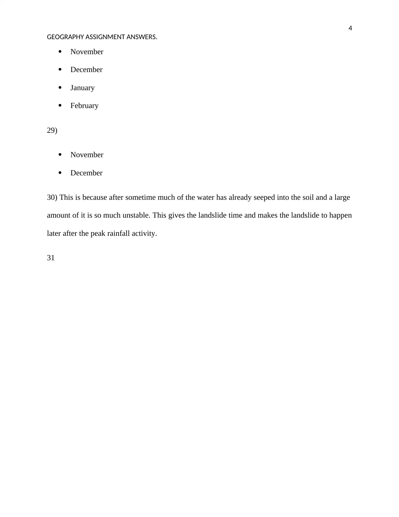
Fig 1.Areas marked with red indicate where movement took place and the road marked by green.
33) The crack on the ground may have enabled water to seep into the ground. This infiltrated
the soil and increased ground water levels which lowered the stability of the slope. Construction
of the road involved burrowing along the slope and removing a big portion of the soil, this left
the slope bare without any supporting soil. (Davies, 2014)
34) The mass wasting could be prevented by terracing the slope to reduce the steepness.
Planting trees and vegetation on the slope. Trees and vegetation help prevent mass wasting by
anchoring the soil alone the cliff. (Zaruba, 2014)
GEOGRAPHY ASSIGNMENT ANSWERS.
Fig 1.Areas marked with red indicate where movement took place and the road marked by green.
33) The crack on the ground may have enabled water to seep into the ground. This infiltrated
the soil and increased ground water levels which lowered the stability of the slope. Construction
of the road involved burrowing along the slope and removing a big portion of the soil, this left
the slope bare without any supporting soil. (Davies, 2014)
34) The mass wasting could be prevented by terracing the slope to reduce the steepness.
Planting trees and vegetation on the slope. Trees and vegetation help prevent mass wasting by
anchoring the soil alone the cliff. (Zaruba, 2014)
⊘ This is a preview!⊘
Do you want full access?
Subscribe today to unlock all pages.
Trusted by 1+ million students worldwide
6
GEOGRAPHY ASSIGNMENT ANSWERS.
35.) The slide was caused by excessive infiltration of water into the ground which increased
ground water levels. This was the main trigger that may have caused the land slide.in figure 16
water is seen issuing from the base of the main scarp after the land slide which proves presence
of excessive amounts of water in the ground. (Rex L.Baum, 2008)
36) The slope area of la conchita should be heavily reforested this anchors the slope ensuring its
protection, there should be terraces in the area to slow down movement of water down slope. The
wall erected to prevent the land slide material should be made taller and have stronger
reinforcements to prevent the land slide.
37)The region of the rock slide seems to have been excessively weathered with exposed and
deep fissures in the rocks on the left side behind the house. This meant that the rocks were
loosely held together before the rock fall hazard. The home in the picture was located at the foot
of the slope which contained the loosely held rocks making it the most vulnerable and its
occupants the first potential victims of a rock fall. (Zaruba, 2014)
38) The area is sloppy comprising of little soil and many rocks. The home is situated at the
bottom of the slope.
39) The boulders that fell on the house fell from the left side of the slope behind the house. This
is evident by the crushed structure and the absence of the tree in the left side adjacent to the
house. This is the damage that was caused by the boulders as they fell.
Paraphrase This Document
Need a fresh take? Get an instant paraphrase of this document with our AI Paraphraser
7
GEOGRAPHY ASSIGNMENT ANSWERS.
40) The area is still considered a high risk for the hazards. This is because the area is still sloppy
and contains loose rocks and large fissures these still pose a potential threat and future hazards
are inevitable without correct control measures.
41
In the pre picture
42)
Landslide and debris avalanche.
Lahars.
Pyroclastic flows. (Walker, 2007)
43
The Hawaiian has a low viscosity while the Mt St Helen has a high viscosity.
44
a) The lava that flows from Mt St Helen has a very high viscosity which makes it to flow slowly.
(P.poland, 2014)
b) High viscosity causes the lava to flow slowly down the mountain. This affects the shape of the
mountain by making it steeper.
c) The lava domes built up by the activity of Mt St Helen are unstable and can erupt violently
when pressure builds within the mountain.
d) If there is an unstable magma chamber below a lava dome acting like a cork and it fails, that
means that the pressure build-up within the chamber will cause a violent explosive eruption.
8
GEOGRAPHY ASSIGNMENT ANSWERS.
45) Putting into consideration that Mt Rainer is bigger than Mt St Helens it poses far more threat
of causing hazards worse than Mt St Helens. The numerous glaciers on its slopes and the can
easily get melted during volcanic eruptions and start flowing down the slope of the mountain.
This is called a lahar and is considered one of the worst volcanic hazards.
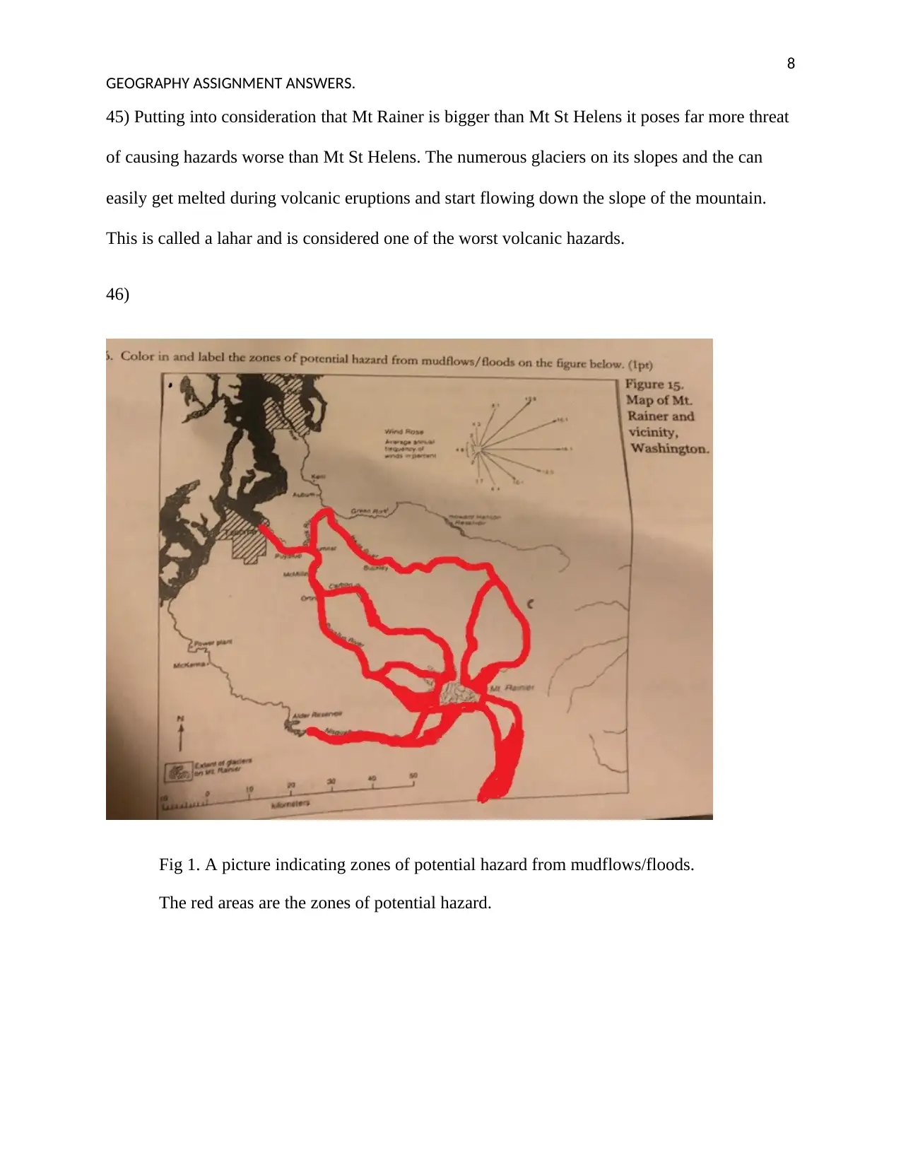
46)
Fig 1. A picture indicating zones of potential hazard from mudflows/floods.
The red areas are the zones of potential hazard.
GEOGRAPHY ASSIGNMENT ANSWERS.
45) Putting into consideration that Mt Rainer is bigger than Mt St Helens it poses far more threat
of causing hazards worse than Mt St Helens. The numerous glaciers on its slopes and the can
easily get melted during volcanic eruptions and start flowing down the slope of the mountain.
This is called a lahar and is considered one of the worst volcanic hazards.
46)
Fig 1. A picture indicating zones of potential hazard from mudflows/floods.
The red areas are the zones of potential hazard.
⊘ This is a preview!⊘
Do you want full access?
Subscribe today to unlock all pages.
Trusted by 1+ million students worldwide
9
GEOGRAPHY ASSIGNMENT ANSWERS.
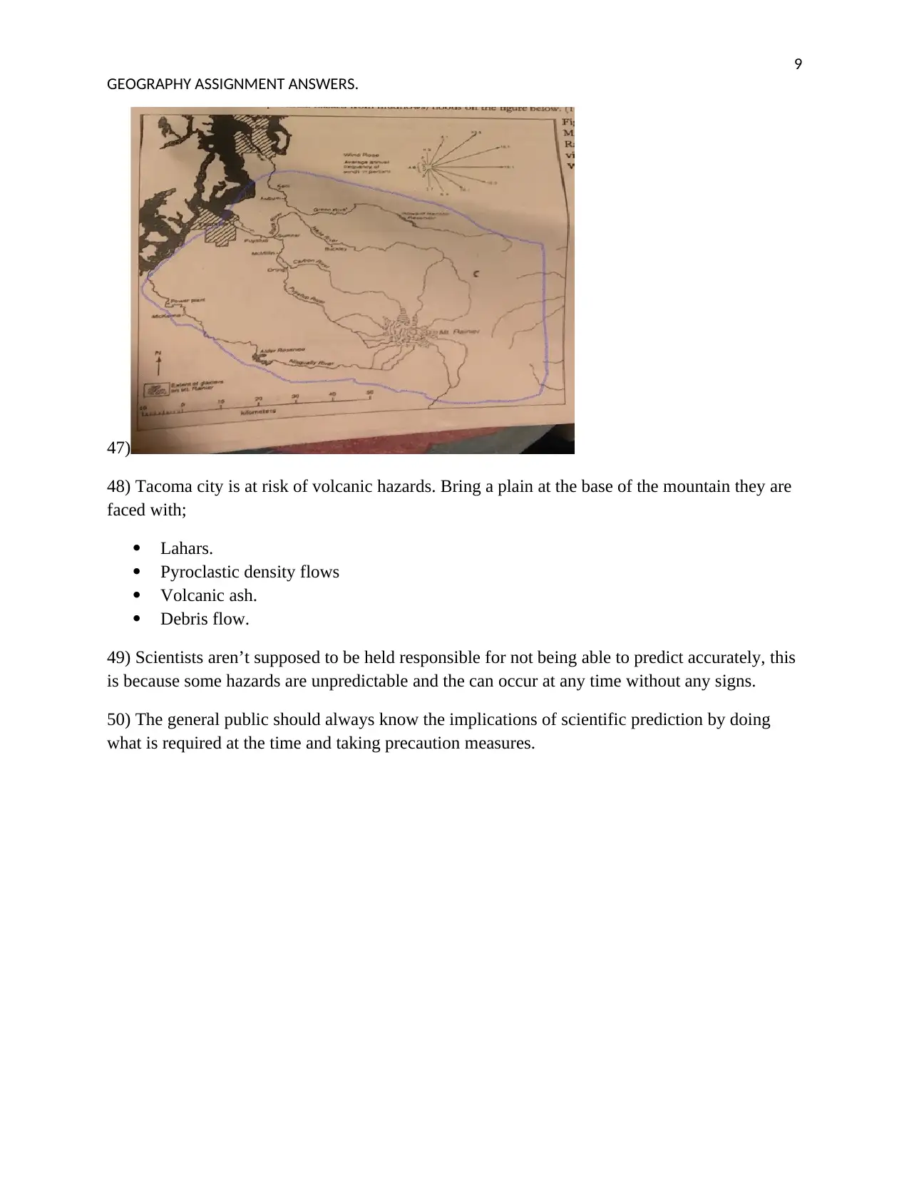
47)
48) Tacoma city is at risk of volcanic hazards. Bring a plain at the base of the mountain they are
faced with;
Lahars.
Pyroclastic density flows
Volcanic ash.
Debris flow.
49) Scientists aren’t supposed to be held responsible for not being able to predict accurately, this
is because some hazards are unpredictable and the can occur at any time without any signs.
50) The general public should always know the implications of scientific prediction by doing
what is required at the time and taking precaution measures.
GEOGRAPHY ASSIGNMENT ANSWERS.
47)
48) Tacoma city is at risk of volcanic hazards. Bring a plain at the base of the mountain they are
faced with;
Lahars.
Pyroclastic density flows
Volcanic ash.
Debris flow.
49) Scientists aren’t supposed to be held responsible for not being able to predict accurately, this
is because some hazards are unpredictable and the can occur at any time without any signs.
50) The general public should always know the implications of scientific prediction by doing
what is required at the time and taking precaution measures.
Paraphrase This Document
Need a fresh take? Get an instant paraphrase of this document with our AI Paraphraser
10
GEOGRAPHY ASSIGNMENT ANSWERS.
References
Davies, T. (2014). Landslide Hazards, Risks, and Disasters. Academic Press.
P.poland, M. (2014). Characteristics of Hawaiian Volcanoes. Government Printing Office.
Peter W. Lipman, J. N. (2009). Hawaiian Volcanoes: Deep Underwater Perspectives, Volume 1. California:
Wiley.
Rex L.Baum, L. H. (2008). Landslides and Engineering Geology of the Seattle, Washington, Area. Seattle:
Geological Society of America.
Walker, S. M. (2007). Volcanoes. Lerner Publications.
Zaruba, Q. (2014). Landslides And Their Control. Elsevier.
1 out of 11