Exploring C. Perry's Neighbourhood Unit Theory and Pune City Evolution
VerifiedAdded on 2022/01/23
|14
|5205
|230
Essay
AI Summary
This essay examines the enduring relevance of C. Perry's neighborhood unit theory in contemporary urban planning, highlighting its impact on housing block and city design while acknowledging its limitations and adaptations over time. It also delves into the evolution of Pune city, tracing its transformation from a small village to a major urban agglomeration, shaped by historical phases, economic liberalization, and migration patterns. The analysis covers Pune's spatial growth, climate, connectivity, administrative setup, and the pressures on its land and water resources due to rapid urbanization, providing a comprehensive overview of the city's development and its challenges.
1- RELEVENCE OF NEIGHBOURHOOD UNIT
BY C. PERRY IN TODAY’S ERA
BY JASNEET SINGH NARU
▪ It is true that Perry's theory has acted as a major paradigm in the field of housing block and
city planning since it was introduced.
▪ However, as planners became aware of the side effects, academic studies and premeditated
practices on housing blocks and life zones in city plans were continuously made.
▪ In housing block plans, the spatial configuration of buildings and facilities have been
continuously changing, which proves that there have been various planned trials.
▪ Some quantitatively analysed the changes in spatial configuration in apartment blocks.
▪ They analysed the placement of the complex entrance, retail shops, residential buildings, the
playground, exercise facility, park and recreation facility, and the school and changes that
occurred in accessibility.
▪ They found that there was a big change in the location of local shops, as they were relocated
from the centre of the block to the boundary.
▪ The Blocks, where Perry's neighbourhood unit theory was reflected faithfully, were
reconstructed, maintaining the location of the school. After the reconstruction, it was
confirmed that the facilities were relocated from the centre to the boundary of the block.
▪ Such changes support pedestrian activity in the boundary streets, but fail to overcome the
exclusivity of the apartment sites.
▪ Additionally, as underground parking lots became common, outdoor space planning including
landscaping became important.
▪ In the 21st century, the trend of high-end apartments emerged. Specifically, construction
companies made their own apartment brands and plans of convenient facilities and outdoor
space became differentiated by brand.
▪ This is the result of a combination of well-being practices and the increased demand from
residents concerning living environments.
▪ This trend resulted in solidifying the exclusiveness of apartments, while various planning
strategies were used for the internal pedestrian spaces and amenities.
▪ Conclusively, the neighbourhood unit theory still suggests basic design principles to various
fields from housing block planning to life zone planning and it is proved to be still useful.
▪ Although there was a time when Perry's theory was applied uniformly despite the social and
economic changes, there were efforts to overcome such uniformity.
▪ Apartment cases were studied focusing on the pedestrian environment in and around the
apartment sites. What is interesting is that new community concepts have been created in the
trend of apartment Complex plans that is different from that proposed in the original theory
and that a new trend has been introduced in the configuration of residents' convenience
facilities.
▪ Specifically, criticisms that the theory only considers physical perspective and excludes social
perspectives and that it composes a self-contained and closed community, have been resolved
through fresh trials such as street oriented spatial configuration and the utilization of
underground space.
Paraphrase This Document
Need a fresh take? Get an instant paraphrase of this document with our AI Paraphraser
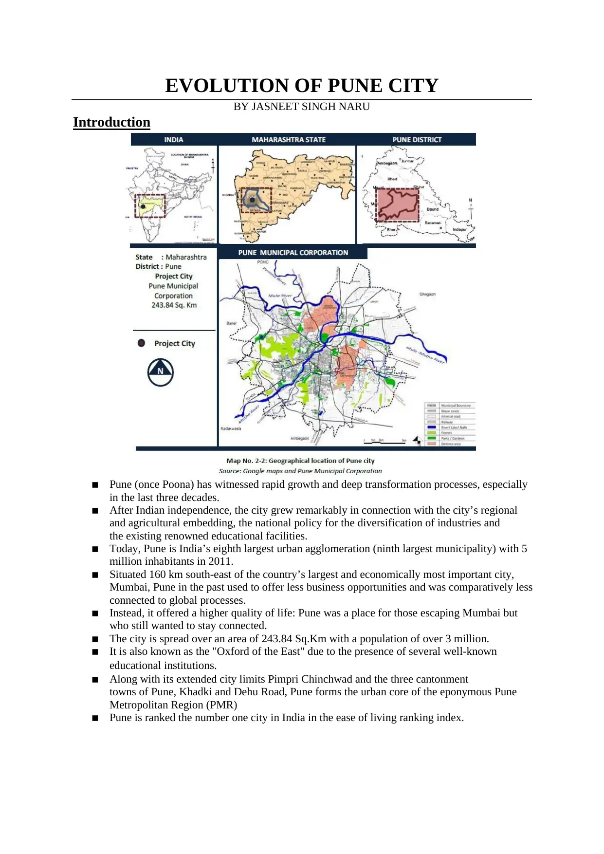
EVOLUTION OF PUNE CITY
BY JASNEET SINGH NARU
Introduction
▪ Pune (once Poona) has witnessed rapid growth and deep transformation processes, especially
in the last three decades.
▪ After Indian independence, the city grew remarkably in connection with the city’s regional
and agricultural embedding, the national policy for the diversification of industries and
the existing renowned educational facilities.
▪ Today, Pune is India’s eighth largest urban agglomeration (ninth largest municipality) with 5
million inhabitants in 2011.
▪ Situated 160 km south-east of the country’s largest and economically most important city,
Mumbai, Pune in the past used to offer less business opportunities and was comparatively less
connected to global processes.
▪ Instead, it offered a higher quality of life: Pune was a place for those escaping Mumbai but
who still wanted to stay connected.
▪ The city is spread over an area of 243.84 Sq.Km with a population of over 3 million.
▪ It is also known as the "Oxford of the East" due to the presence of several well-known
educational institutions.
▪ Along with its extended city limits Pimpri Chinchwad and the three cantonment
towns of Pune, Khadki and Dehu Road, Pune forms the urban core of the eponymous Pune
Metropolitan Region (PMR)
▪ Pune is ranked the number one city in India in the ease of living ranking index.
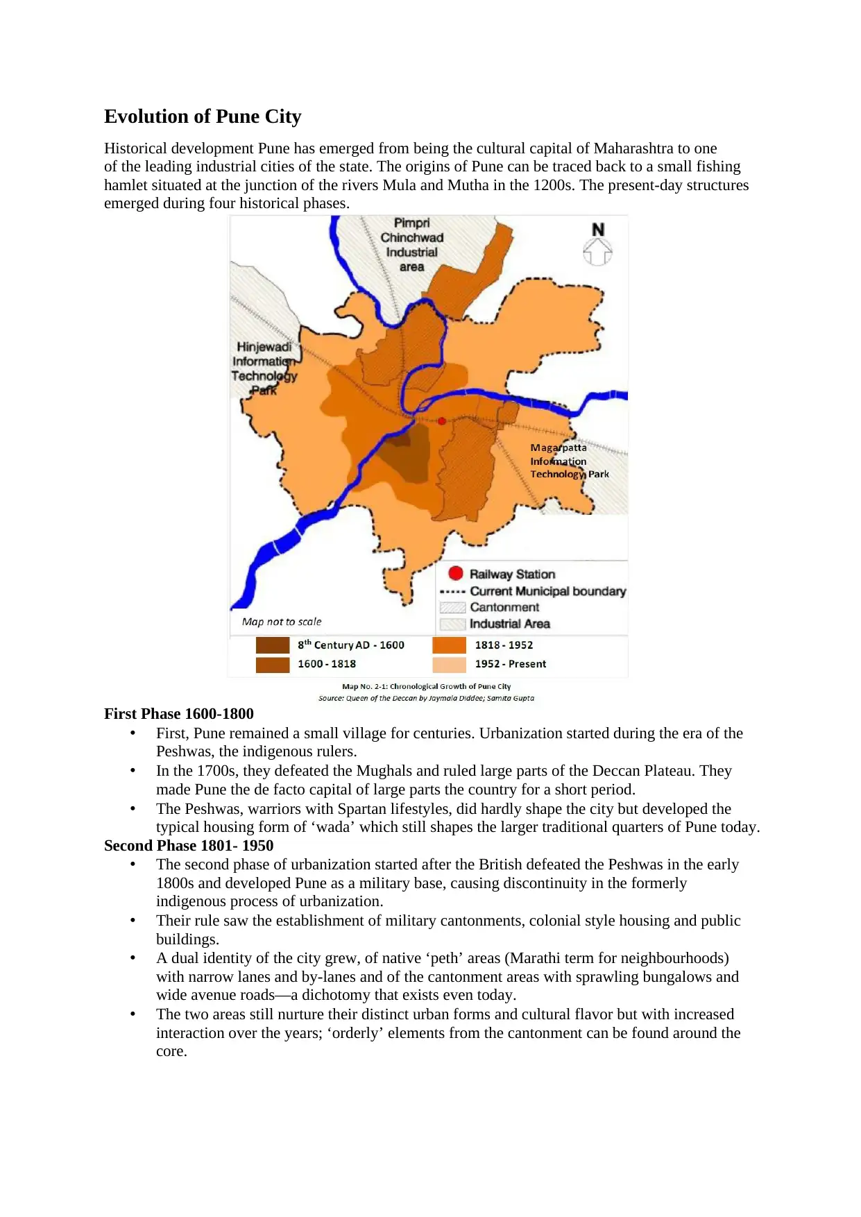
Evolution of Pune City
Historical development Pune has emerged from being the cultural capital of Maharashtra to one
of the leading industrial cities of the state. The origins of Pune can be traced back to a small fishing
hamlet situated at the junction of the rivers Mula and Mutha in the 1200s. The present-day structures
emerged during four historical phases.
First Phase 1600-1800
• First, Pune remained a small village for centuries. Urbanization started during the era of the
Peshwas, the indigenous rulers.
• In the 1700s, they defeated the Mughals and ruled large parts of the Deccan Plateau. They
made Pune the de facto capital of large parts the country for a short period.
• The Peshwas, warriors with Spartan lifestyles, did hardly shape the city but developed the
typical housing form of ‘wada’ which still shapes the larger traditional quarters of Pune today.
Second Phase 1801- 1950
• The second phase of urbanization started after the British defeated the Peshwas in the early
1800s and developed Pune as a military base, causing discontinuity in the formerly
indigenous process of urbanization.
• Their rule saw the establishment of military cantonments, colonial style housing and public
buildings.
• A dual identity of the city grew, of native ‘peth’ areas (Marathi term for neighbourhoods)
with narrow lanes and by-lanes and of the cantonment areas with sprawling bungalows and
wide avenue roads—a dichotomy that exists even today.
• The two areas still nurture their distinct urban forms and cultural flavor but with increased
interaction over the years; ‘orderly’ elements from the cantonment can be found around the
core.
⊘ This is a preview!⊘
Do you want full access?
Subscribe today to unlock all pages.
Trusted by 1+ million students worldwide
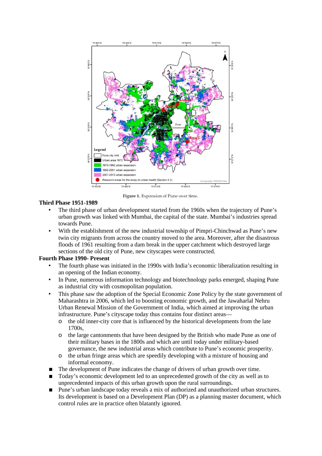
Third Phase 1951-1989
• The third phase of urban development started from the 1960s when the trajectory of Pune’s
urban growth was linked with Mumbai, the capital of the state. Mumbai’s industries spread
towards Pune.
• With the establishment of the new industrial township of Pimpri-Chinchwad as Pune’s new
twin city migrants from across the country moved to the area. Moreover, after the disastrous
floods of 1961 resulting from a dam break in the upper catchment which destroyed large
sections of the old city of Pune, new cityscapes were constructed.
Fourth Phase 1990- Present
• The fourth phase was initiated in the 1990s with India’s economic liberalization resulting in
an opening of the Indian economy.
• In Pune, numerous information technology and biotechnology parks emerged, shaping Pune
as industrial city with cosmopolitan population.
• This phase saw the adoption of the Special Economic Zone Policy by the state government of
Maharashtra in 2006, which led to boosting economic growth, and the Jawaharlal Nehru
Urban Renewal Mission of the Government of India, which aimed at improving the urban
infrastructure. Pune’s cityscape today thus contains four distinct areas—
o the old inner-city core that is influenced by the historical developments from the late
1700s,
o the large cantonments that have been designed by the British who made Pune as one of
their military bases in the 1800s and which are until today under military-based
governance, the new industrial areas which contribute to Pune’s economic prosperity.
o the urban fringe areas which are speedily developing with a mixture of housing and
informal economy.
▪ The development of Pune indicates the change of drivers of urban growth over time.
▪ Today’s economic development led to an unprecedented growth of the city as well as to
unprecedented impacts of this urban growth upon the rural surroundings.
▪ Pune’s urban landscape today reveals a mix of authorized and unauthorized urban structures.
Its development is based on a Development Plan (DP) as a planning master document, which
control rules are in practice often blatantly ignored.
Paraphrase This Document
Need a fresh take? Get an instant paraphrase of this document with our AI Paraphraser
Pune Growth due to migration: -
▪ Pune’s growth is related to significant in-migration: In 1941, Pune had 375,000 inhabitants, in
2011, the population of the urban agglomeration—consisting of the Pune Municipal
Corporation, the cantonments Pune and Khadki, the Pimpri Chinchwad Municipal
Corporation (PCMC) and to the North Dehu Road and Dehu—crossed the threshold of five
million inhabitants.
▪ The population of the PMC reached 3.1 million.
▪ Migrant population was at 20%, from which two third came from the state Of Maharashtra.
▪ Most of the inter-state migrants came from the neighbouring states Andhra Pradesh (before its
bifurcation) and Karnataka.
▪ Pune Municipal Corporation estimates that the population growth rate will slow down from
3.39% (2007–2012) to 2.13% (2022–2027).
▪ However, PMC expects the population to grow to 5.7 million by 2027. The World
Urbanisation Prospects predict that the whole Pune urban agglomeration will reach 8.1
million inhabitants by 2030.
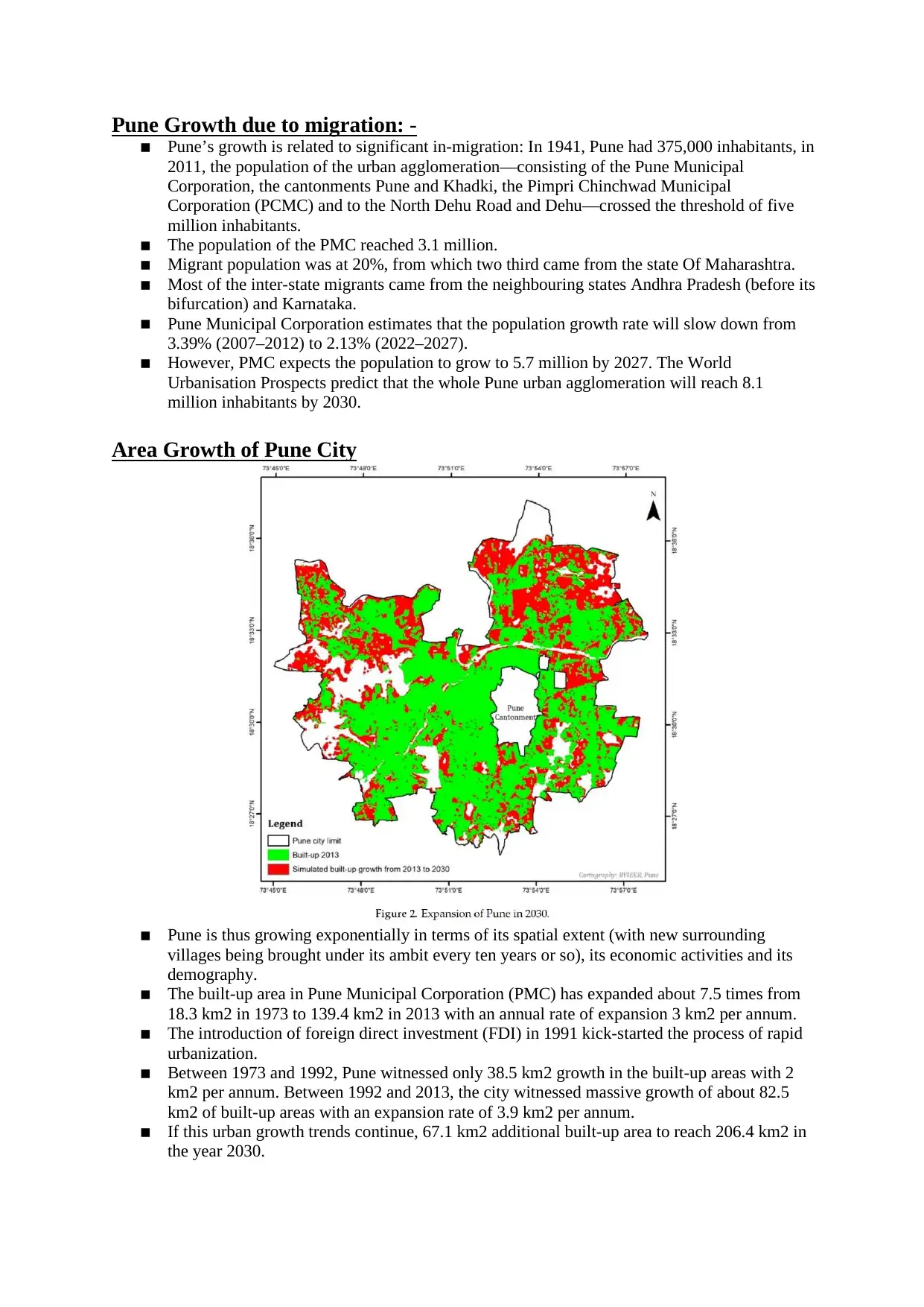
Area Growth of Pune City
▪ Pune is thus growing exponentially in terms of its spatial extent (with new surrounding
villages being brought under its ambit every ten years or so), its economic activities and its
demography.
▪ The built-up area in Pune Municipal Corporation (PMC) has expanded about 7.5 times from
18.3 km2 in 1973 to 139.4 km2 in 2013 with an annual rate of expansion 3 km2 per annum.
▪ The introduction of foreign direct investment (FDI) in 1991 kick-started the process of rapid
urbanization.
▪ Between 1973 and 1992, Pune witnessed only 38.5 km2 growth in the built-up areas with 2
km2 per annum. Between 1992 and 2013, the city witnessed massive growth of about 82.5
km2 of built-up areas with an expansion rate of 3.9 km2 per annum.
▪ If this urban growth trends continue, 67.1 km2 additional built-up area to reach 206.4 km2 in
the year 2030.
▪ Pune’s growth is related to significant in-migration: In 1941, Pune had 375,000 inhabitants, in
2011, the population of the urban agglomeration—consisting of the Pune Municipal
Corporation, the cantonments Pune and Khadki, the Pimpri Chinchwad Municipal
Corporation (PCMC) and to the North Dehu Road and Dehu—crossed the threshold of five
million inhabitants.
▪ The population of the PMC reached 3.1 million.
▪ Migrant population was at 20%, from which two third came from the state Of Maharashtra.
▪ Most of the inter-state migrants came from the neighbouring states Andhra Pradesh (before its
bifurcation) and Karnataka.
▪ Pune Municipal Corporation estimates that the population growth rate will slow down from
3.39% (2007–2012) to 2.13% (2022–2027).
▪ However, PMC expects the population to grow to 5.7 million by 2027. The World
Urbanisation Prospects predict that the whole Pune urban agglomeration will reach 8.1
million inhabitants by 2030.
Area Growth of Pune City
▪ Pune is thus growing exponentially in terms of its spatial extent (with new surrounding
villages being brought under its ambit every ten years or so), its economic activities and its
demography.
▪ The built-up area in Pune Municipal Corporation (PMC) has expanded about 7.5 times from
18.3 km2 in 1973 to 139.4 km2 in 2013 with an annual rate of expansion 3 km2 per annum.
▪ The introduction of foreign direct investment (FDI) in 1991 kick-started the process of rapid
urbanization.
▪ Between 1973 and 1992, Pune witnessed only 38.5 km2 growth in the built-up areas with 2
km2 per annum. Between 1992 and 2013, the city witnessed massive growth of about 82.5
km2 of built-up areas with an expansion rate of 3.9 km2 per annum.
▪ If this urban growth trends continue, 67.1 km2 additional built-up area to reach 206.4 km2 in
the year 2030.
Climate
Pune has a tropical wet and dry climate, with three distinct seasons- summer, rains and mild winter.
The height above sea level and the leeward location with reference to the Western Ghats have made
the city climate moderate and salubrious.
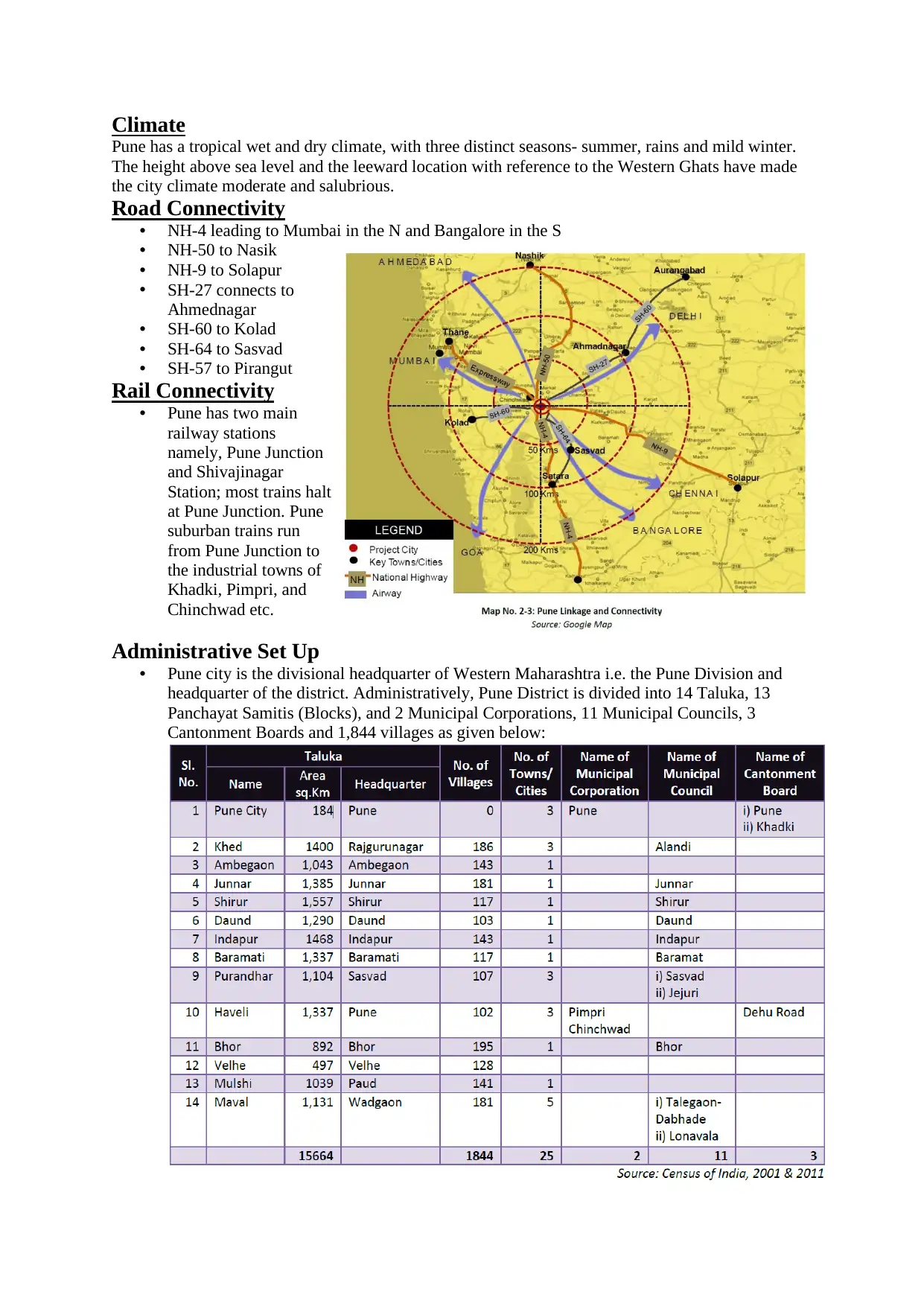
Road Connectivity
• NH-4 leading to Mumbai in the N and Bangalore in the S
• NH-50 to Nasik
• NH-9 to Solapur
• SH-27 connects to
Ahmednagar
• SH-60 to Kolad
• SH-64 to Sasvad
• SH-57 to Pirangut
Rail Connectivity
• Pune has two main
railway stations
namely, Pune Junction
and Shivajinagar
Station; most trains halt
at Pune Junction. Pune
suburban trains run
from Pune Junction to
the industrial towns of
Khadki, Pimpri, and
Chinchwad etc.
Administrative Set Up
• Pune city is the divisional headquarter of Western Maharashtra i.e. the Pune Division and
headquarter of the district. Administratively, Pune District is divided into 14 Taluka, 13
Panchayat Samitis (Blocks), and 2 Municipal Corporations, 11 Municipal Councils, 3
Cantonment Boards and 1,844 villages as given below:
Pune has a tropical wet and dry climate, with three distinct seasons- summer, rains and mild winter.
The height above sea level and the leeward location with reference to the Western Ghats have made
the city climate moderate and salubrious.
Road Connectivity
• NH-4 leading to Mumbai in the N and Bangalore in the S
• NH-50 to Nasik
• NH-9 to Solapur
• SH-27 connects to
Ahmednagar
• SH-60 to Kolad
• SH-64 to Sasvad
• SH-57 to Pirangut
Rail Connectivity
• Pune has two main
railway stations
namely, Pune Junction
and Shivajinagar
Station; most trains halt
at Pune Junction. Pune
suburban trains run
from Pune Junction to
the industrial towns of
Khadki, Pimpri, and
Chinchwad etc.
Administrative Set Up
• Pune city is the divisional headquarter of Western Maharashtra i.e. the Pune Division and
headquarter of the district. Administratively, Pune District is divided into 14 Taluka, 13
Panchayat Samitis (Blocks), and 2 Municipal Corporations, 11 Municipal Councils, 3
Cantonment Boards and 1,844 villages as given below:
⊘ This is a preview!⊘
Do you want full access?
Subscribe today to unlock all pages.
Trusted by 1+ million students worldwide
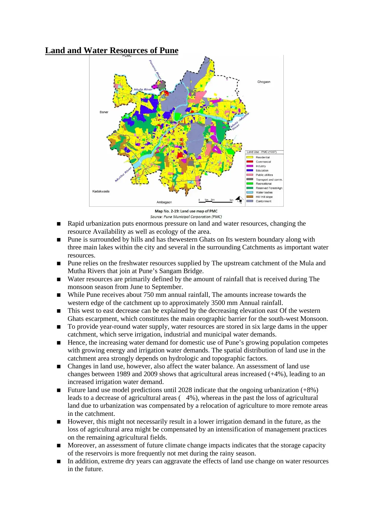
Land and Water Resources of Pune
▪ Rapid urbanization puts enormous pressure on land and water resources, changing the
resource Availability as well as ecology of the area.
▪ Pune is surrounded by hills and has thewestern Ghats on Its western boundary along with
three main lakes within the city and several in the surrounding Catchments as important water
resources.
▪ Pune relies on the freshwater resources supplied by The upstream catchment of the Mula and
Mutha Rivers that join at Pune’s Sangam Bridge.
▪ Water resources are primarily defined by the amount of rainfall that is received during The
monsoon season from June to September.
▪ While Pune receives about 750 mm annual rainfall, The amounts increase towards the
western edge of the catchment up to approximately 3500 mm Annual rainfall.
▪ This west to east decrease can be explained by the decreasing elevation east Of the western
Ghats escarpment, which constitutes the main orographic barrier for the south-west Monsoon.
▪ To provide year-round water supply, water resources are stored in six large dams in the upper
catchment, which serve irrigation, industrial and municipal water demands.
▪ Hence, the increasing water demand for domestic use of Pune’s growing population competes
with growing energy and irrigation water demands. The spatial distribution of land use in the
catchment area strongly depends on hydrologic and topographic factors.
▪ Changes in land use, however, also affect the water balance. An assessment of land use
changes between 1989 and 2009 shows that agricultural areas increased (+4%), leading to an
increased irrigation water demand.
▪ Future land use model predictions until 2028 indicate that the ongoing urbanization (+8%)
leads to a decrease of agricultural areas (4%), whereas in the past the loss of agricultural
land due to urbanization was compensated by a relocation of agriculture to more remote areas
in the catchment.
▪ However, this might not necessarily result in a lower irrigation demand in the future, as the
loss of agricultural area might be compensated by an intensification of management practices
on the remaining agricultural fields.
▪ Moreover, an assessment of future climate change impacts indicates that the storage capacity
of the reservoirs is more frequently not met during the rainy season.
▪ In addition, extreme dry years can aggravate the effects of land use change on water resources
in the future.
Paraphrase This Document
Need a fresh take? Get an instant paraphrase of this document with our AI Paraphraser
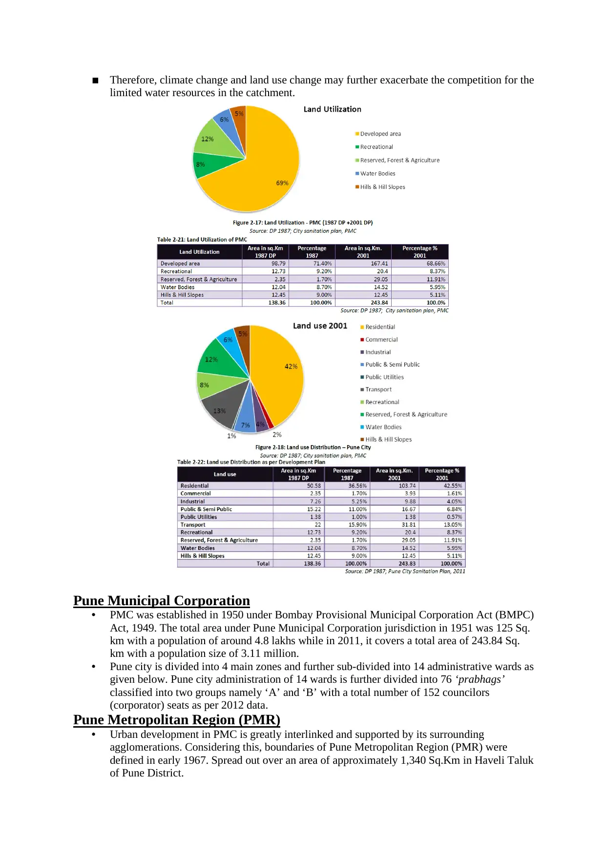
▪ Therefore, climate change and land use change may further exacerbate the competition for the
limited water resources in the catchment.
Pune Municipal Corporation
• PMC was established in 1950 under Bombay Provisional Municipal Corporation Act (BMPC)
Act, 1949. The total area under Pune Municipal Corporation jurisdiction in 1951 was 125 Sq.
km with a population of around 4.8 lakhs while in 2011, it covers a total area of 243.84 Sq.
km with a population size of 3.11 million.
• Pune city is divided into 4 main zones and further sub-divided into 14 administrative wards as
given below. Pune city administration of 14 wards is further divided into 76 ‘prabhags’
classified into two groups namely ‘A’ and ‘B’ with a total number of 152 councilors
(corporator) seats as per 2012 data.
Pune Metropolitan Region (PMR)
• Urban development in PMC is greatly interlinked and supported by its surrounding
agglomerations. Considering this, boundaries of Pune Metropolitan Region (PMR) were
defined in early 1967. Spread out over an area of approximately 1,340 Sq.Km in Haveli Taluk
of Pune District.
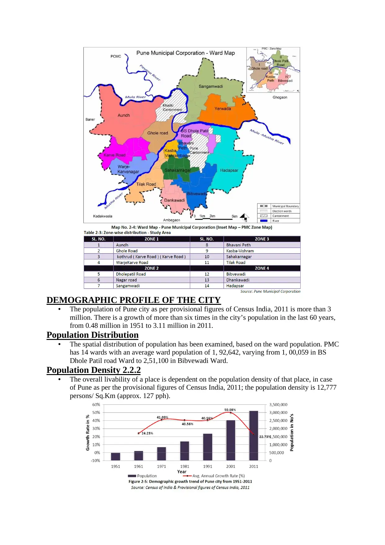
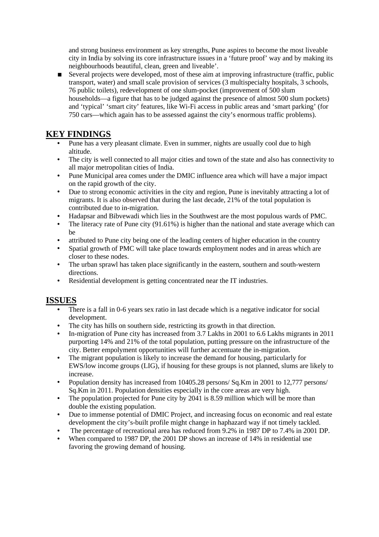
DEMOGRAPHIC PROFILE OF THE CITY
• The population of Pune city as per provisional figures of Census India, 2011 is more than 3
million. There is a growth of more than six times in the city’s population in the last 60 years,
from 0.48 million in 1951 to 3.11 million in 2011.
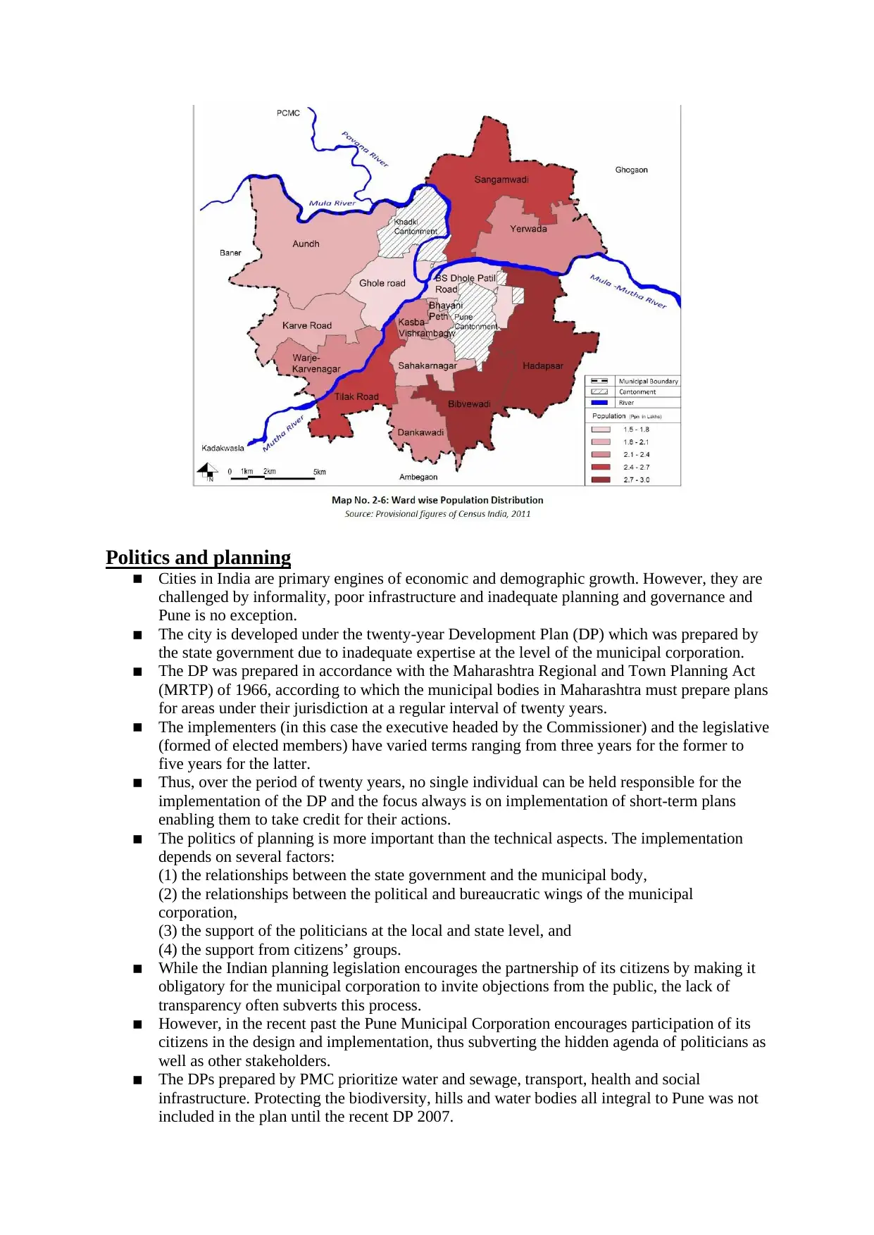
Population Distribution
• The spatial distribution of population has been examined, based on the ward population. PMC
has 14 wards with an average ward population of 1, 92,642, varying from 1, 00,059 in BS
Dhole Patil road Ward to 2,51,100 in Bibvewadi Ward.
Population Density 2.2.2
• The overall livability of a place is dependent on the population density of that place, in case
of Pune as per the provisional figures of Census India, 2011; the population density is 12,777
persons/ Sq.Km (approx. 127 pph).
• The population of Pune city as per provisional figures of Census India, 2011 is more than 3
million. There is a growth of more than six times in the city’s population in the last 60 years,
from 0.48 million in 1951 to 3.11 million in 2011.
Population Distribution
• The spatial distribution of population has been examined, based on the ward population. PMC
has 14 wards with an average ward population of 1, 92,642, varying from 1, 00,059 in BS
Dhole Patil road Ward to 2,51,100 in Bibvewadi Ward.
Population Density 2.2.2
• The overall livability of a place is dependent on the population density of that place, in case
of Pune as per the provisional figures of Census India, 2011; the population density is 12,777
persons/ Sq.Km (approx. 127 pph).
⊘ This is a preview!⊘
Do you want full access?
Subscribe today to unlock all pages.
Trusted by 1+ million students worldwide
Politics and planning
▪ Cities in India are primary engines of economic and demographic growth. However, they are
challenged by informality, poor infrastructure and inadequate planning and governance and
Pune is no exception.
▪ The city is developed under the twenty-year Development Plan (DP) which was prepared by
the state government due to inadequate expertise at the level of the municipal corporation.
▪ The DP was prepared in accordance with the Maharashtra Regional and Town Planning Act
(MRTP) of 1966, according to which the municipal bodies in Maharashtra must prepare plans
for areas under their jurisdiction at a regular interval of twenty years.
▪ The implementers (in this case the executive headed by the Commissioner) and the legislative
(formed of elected members) have varied terms ranging from three years for the former to
five years for the latter.
▪ Thus, over the period of twenty years, no single individual can be held responsible for the
implementation of the DP and the focus always is on implementation of short-term plans
enabling them to take credit for their actions.
▪ The politics of planning is more important than the technical aspects. The implementation
depends on several factors:
(1) the relationships between the state government and the municipal body,
(2) the relationships between the political and bureaucratic wings of the municipal
corporation,
(3) the support of the politicians at the local and state level, and
(4) the support from citizens’ groups.
▪ While the Indian planning legislation encourages the partnership of its citizens by making it
obligatory for the municipal corporation to invite objections from the public, the lack of
transparency often subverts this process.
▪ However, in the recent past the Pune Municipal Corporation encourages participation of its
citizens in the design and implementation, thus subverting the hidden agenda of politicians as
well as other stakeholders.
▪ The DPs prepared by PMC prioritize water and sewage, transport, health and social
infrastructure. Protecting the biodiversity, hills and water bodies all integral to Pune was not
included in the plan until the recent DP 2007.
Paraphrase This Document
Need a fresh take? Get an instant paraphrase of this document with our AI Paraphraser
▪ Another example for new pathways in the planning process is the development of the
Magarpatta City Township.
▪ This new settlement for 100,000 people was built as a city within a city through public private
partnerships.
▪ The basis was the pooling of land by 120 farming families for this new urban development
pattern to enable citizens to escape from the informalities of the present city development
process.
▪ This model has been replicated in Amonara, a similar township and Nanded City, a venture
similar to Magarpatta.
▪ It is no surprise that given the high degree of informality, unstructured processes and
duplication of responsibilities, Pune as a city lags behind in the development of infrastructure
and other services needed to serve its large urban population in its quest to be a ‘world class
city’.
▪ Thus, in the face of increasing urbanization and a growing backlog in infrastructure
investments, the Jawaharlal Nehru Urban Renewal Mission (JNNURM) was launched in
2005. The key goal was to develop cities as engines of economic growth by incentivizing
urban reforms at state and city level through the provision of grants to fast track infrastructure
development.
▪ The Mission follows on from the 14th Constitutional Amendment Act, 1992 that strengthened
decentralization of the management of cities under urban local bodies (ULB).
▪ The two phases over which JNNURM was implemented were only moderately successful due
to its ineffective urban land acquisition processes and funding delays.
▪ The performance audit of the Mission by the Comptroller and Auditor General (CAG),
showed huge deficiencies.
▪ The CAG report stated that only 22 of the 1517 projects approved in 2005 and 231 of 1298
approved in 2011 were completed as of 31 March 2011.
▪ While housing and urban infrastructure projects were implemented, the process of bringing in
institutional, financial and governance structures to make the ULBs efficient, accountable and
transparent was not achieved.
▪ This was thus the genesis of the Smart City Mission (SCM) that is presently being
implemented.
▪ The ‘Smart City’ phase was introduced by the present central government in 2016. While the
definition of ‘smart cities’ is ambiguous world over, the goal of the Smart City Mission in
India is to create cities with smart physical, social, institutional and economic infrastructure
including clean technology use, widespread information and communication technology
reliance, financing via public private partnerships and private sector investments, improved
citizen consultation and ‘smart’ or e-governance initiatives.
▪ Pune was one of the ninety-eight cities to be selected in the first phase of the SCM. Plans
require following an area-based approach, such that certain areas within a city would be the
focus of being made ‘smart’, either by upgrading areas in existing cities through retrofitting or
redevelopment or developing new green spaces of more than 250 acres within the geographic
limits of the ULB or Urban Development Authority (UDA).
▪ Moreover, cities are required to implement a pan-city approach to improve city-wide
infrastructure in one or more sectors. The SCM guidelines call for extensive citizen and
stakeholder consultation.
▪ In Pune, the development began in late 2015 with the help of consultancy or ‘hand-holding’
agencies to assist in the conceptualization and development of area-based and pan-city
projects.
▪ For Pune a ‘Special Purpose Vehicle’ (SPV) has been instituted to oversee and implement the
smart city plan. The SPV is a pre-requisite for disbursement of money announced by the
Central government and is a 50:50 partnership between the State government and Pune
Municipal Corporation with 15 board members.
▪ A smart city strategy for Pune was developed in 2015. The municipal corporation claims to
have involved 50% of the citizens in the development of this strategy [8]. The strategy is
guided by the vision: ‘Leveraging its rich cultural and natural heritage, strong human capital
and strong business environment as key strengths, Pune aspires to become the most liveable
city in India by solving its core infrastructure issues in a ‘future proof’ way and by making its
neighbourhoods beautiful, clean, green and liveable’.
▪ Several projects were developed, most of these aim at improving infrastructure (traffic, public
transport, water) and small scale provision of services (3 multispecialty hospitals, 3 schools,
76 public toilets), redevelopment of one slum-pocket (improvement of 500 slum
households—a figure that has to be judged against the presence of almost 500 slum pockets)
and ‘typical’ ‘smart city’ features, like Wi-Fi access in public areas and ‘smart parking’ (for
750 cars—which again has to be assessed against the city’s enormous traffic problems).
KEY FINDINGS
• Pune has a very pleasant climate. Even in summer, nights are usually cool due to high
altitude.
• The city is well connected to all major cities and town of the state and also has connectivity to
all major metropolitan cities of India.
• Pune Municipal area comes under the DMIC influence area which will have a major impact
on the rapid growth of the city.
• Due to strong economic activities in the city and region, Pune is inevitably attracting a lot of
migrants. It is also observed that during the last decade, 21% of the total population is
contributed due to in-migration.
• Hadapsar and Bibvewadi which lies in the Southwest are the most populous wards of PMC.
• The literacy rate of Pune city (91.61%) is higher than the national and state average which can
be
• attributed to Pune city being one of the leading centers of higher education in the country
• Spatial growth of PMC will take place towards employment nodes and in areas which are
closer to these nodes.
• The urban sprawl has taken place significantly in the eastern, southern and south-western
directions.
• Residential development is getting concentrated near the IT industries.
ISSUES
• There is a fall in 0-6 years sex ratio in last decade which is a negative indicator for social
development.
• The city has hills on southern side, restricting its growth in that direction.
• In-migration of Pune city has increased from 3.7 Lakhs in 2001 to 6.6 Lakhs migrants in 2011
purporting 14% and 21% of the total population, putting pressure on the infrastructure of the
city. Better empolyment opportunities will further accentuate the in-migration.
• The migrant population is likely to increase the demand for housing, particularly for
EWS/low income groups (LIG), if housing for these groups is not planned, slums are likely to
increase.
• Population density has increased from 10405.28 persons/ Sq.Km in 2001 to 12,777 persons/
Sq.Km in 2011. Population densities especially in the core areas are very high.
• The population projected for Pune city by 2041 is 8.59 million which will be more than
double the existing population.
• Due to immense potential of DMIC Project, and increasing focus on economic and real estate
development the city’s-built profile might change in haphazard way if not timely tackled.
• The percentage of recreational area has reduced from 9.2% in 1987 DP to 7.4% in 2001 DP.
• When compared to 1987 DP, the 2001 DP shows an increase of 14% in residential use
favoring the growing demand of housing.
⊘ This is a preview!⊘
Do you want full access?
Subscribe today to unlock all pages.
Trusted by 1+ million students worldwide
1 out of 14
Your All-in-One AI-Powered Toolkit for Academic Success.
+13062052269
info@desklib.com
Available 24*7 on WhatsApp / Email
![[object Object]](/_next/static/media/star-bottom.7253800d.svg)
Unlock your academic potential
Copyright © 2020–2026 A2Z Services. All Rights Reserved. Developed and managed by ZUCOL.