Introduction to Geoscience Assignment 2022
VerifiedAdded on 2022/08/25
|13
|2998
|20
Assignment
AI Summary
Contribute Materials
Your contribution can guide someone’s learning journey. Share your
documents today.
GEOL 1011: Introduction to Geoscience 1
Assignment 5
This assignment is worth 12% of your total course mark. Please type your
answers directly into this document and submit the assignment to your
Open Learning Faculty Member.
Part A: Short-Answer Questions (20 points in total)
Answer the following questions as succinctly as you can. None of the
answers should be more than a couple of sentences (100 words or less).
1. List the various factors that govern the wavelength and
amplitude of wind waves. (2 points)
Velocity of the wave
Frequency of the wave
2. Explain why waves get refracted in near-shore areas and
describe some of the implications of this refraction. (3
points)
Waves in the deep waters bend as they approach the shore so as to be
parallel with the shore line. The friction created between the
continental shelf and the water carrying waves slows down the waves
at that point causing the waves to bend. This causes the waves to face
the shoreline directly which results to the wave crest bending.
3. Explain the mechanism that has resulted in the presence of
post-glacial aged marine deposits tens of metres above
present-day sea level at numerous locations along the
British Columbia coast. (2 points)
This is the post glacial rebound (PGR). It brings about the ascent of the
large landmasses after the lifting period of the tremendous loads of the
ice sheets during the last glacial time frame. The huge load of the ice
sheets had caused isostatic depression. Both of these, PGR and
isostatic depression, are periods of cold isostasy which is the twisting
of the Earth's outer layer from the modifications in ice mass changes
and dissemination.
Now in glacial phase when the ice sheets that are a few kilometers
thick push down the Earth's outer layer to produce a depression. When
the glacier retreats, the loss of the weight results to the land elevation
and mantle material return simply under the deglaciated area. This is
why we have marine deposits tens of meters above the existing sea
level along the coast of British Columbia.
TRU Open Learning
Secure Best Marks with AI Grader
Need help grading? Try our AI Grader for instant feedback on your assignments.
2 Assignment 5
4. Describe the property of greenhouse gases that enables
them to trap heat within the atmosphere. (2 points)
A greenhouse gas has three basic properties associated with them,
which are, the wavelength of the energy which the gas absorbs from
sun’s radiation, how much energy it absorbs from the radiation, and
how long the gas molecules stays intact in the atmosphere without
disintegrating. In the infrared region of the light spectrum is where the
greenhouse gas molecules absorb the energy. This region is usually
associate with heat.
5. Explain the role of albedo in the Earth’s climate and give an
example of an albedo change that is a positive feedback
mechanism. (3 points)
Albedo is a function of the reflectivity of the surface of the Earth. Ice-
albedo feedback is a clear positive response to the climate system.
Hotter temperatures result to ice masses on the poles (North and
South) and high elevated areas such as mountain peaks to melt. This
ice mases are useful because they reflect a percentage the solar energy
back to space.
Ice–albedo feedback is a positive feedback climate process. This means
the change in the surface area of ice masses on the planet will alter
accordingly the albedo and the surface temperature of the entire
planet. For example, global warming tends to decrease the ice surface
area of the earth which leads to less sun’s radiation being reflected to
the space which lead to more global warming.
6. Summarize the main human activities that contribute to climate
change.
(2 points)
Clearing of forests, burning of fossil fuels and the green gases
produced from industrial activities that cause air pollution contribute
to climate change.
7. Describe the geological origins of the Appalachian fold belt of
eastern North America. (2 points)
At about 350 Ma, the fragment of Gondwana currently Africa smashed
into North America's eastern coast, pushing volcanic islands and
sedimentary layers far inland to form the Appalachian crease belt.
During the Devonian the Appalachian Mountains would have been
TRU Open Learning
GEOL 1011: Introduction to Geoscience 3
equal in degree and height to the Himalayas.
8. Which of the individual terranes of the Intermontane Super terrane
(listed in Figure 21.14 in your textbook) do you think might have
reached North America first? Explain your answer. (2 points)
The Quesnel terrane of the intermontane outstanding terrane is
reached at North America due to the fact it is moving with excessive
speed from Mesozoic time towards the North American plate.
9. Explain what makes the Queen Charlotte Fault a transform fault.
(2 points)
The fault has been the source of large, very large, and great
earthquakes.
Part B: Exercises (45 points in total)
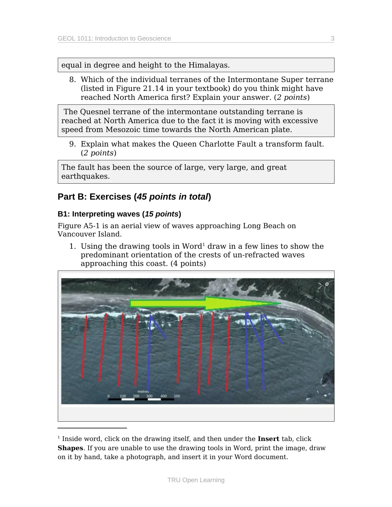
B1: Interpreting waves (15 points)
Figure A5-1 is an aerial view of waves approaching Long Beach on
Vancouver Island.
1. Using the drawing tools in Word1 draw in a few lines to show the
predominant orientation of the crests of un-refracted waves
approaching this coast. (4 points)
1 Inside word, click on the drawing itself, and then under the Insert tab, click
Shapes. If you are unable to use the drawing tools in Word, print the image, draw
on it by hand, take a photograph, and insert it in your Word document.
TRU Open Learning
equal in degree and height to the Himalayas.
8. Which of the individual terranes of the Intermontane Super terrane
(listed in Figure 21.14 in your textbook) do you think might have
reached North America first? Explain your answer. (2 points)
The Quesnel terrane of the intermontane outstanding terrane is
reached at North America due to the fact it is moving with excessive
speed from Mesozoic time towards the North American plate.
9. Explain what makes the Queen Charlotte Fault a transform fault.
(2 points)
The fault has been the source of large, very large, and great
earthquakes.
Part B: Exercises (45 points in total)
B1: Interpreting waves (15 points)
Figure A5-1 is an aerial view of waves approaching Long Beach on
Vancouver Island.
1. Using the drawing tools in Word1 draw in a few lines to show the
predominant orientation of the crests of un-refracted waves
approaching this coast. (4 points)
1 Inside word, click on the drawing itself, and then under the Insert tab, click
Shapes. If you are unable to use the drawing tools in Word, print the image, draw
on it by hand, take a photograph, and insert it in your Word document.
TRU Open Learning
4 Assignment 5
The red lines show the direction of crest and for the un-refracted waves
crest would be aligned orthogonally to the shores.
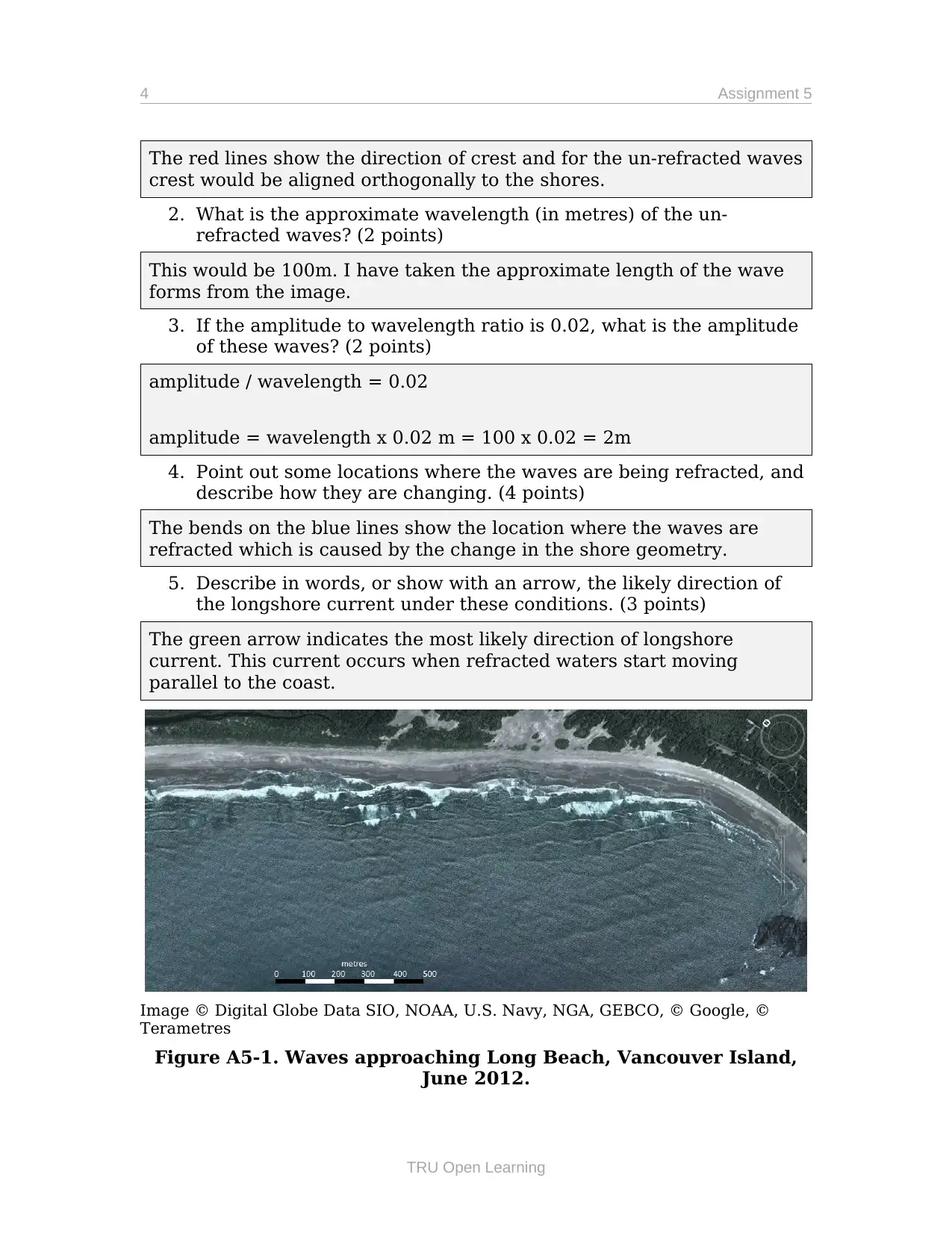
2. What is the approximate wavelength (in metres) of the un-
refracted waves? (2 points)
This would be 100m. I have taken the approximate length of the wave
forms from the image.
3. If the amplitude to wavelength ratio is 0.02, what is the amplitude
of these waves? (2 points)
amplitude / wavelength = 0.02
amplitude = wavelength x 0.02 m = 100 x 0.02 = 2m
4. Point out some locations where the waves are being refracted, and
describe how they are changing. (4 points)
The bends on the blue lines show the location where the waves are
refracted which is caused by the change in the shore geometry.
5. Describe in words, or show with an arrow, the likely direction of
the longshore current under these conditions. (3 points)
The green arrow indicates the most likely direction of longshore
current. This current occurs when refracted waters start moving
parallel to the coast.
Image © Digital Globe Data SIO, NOAA, U.S. Navy, NGA, GEBCO, © Google, ©
Terametres
Figure A5-1. Waves approaching Long Beach, Vancouver Island,
June 2012.
TRU Open Learning
The red lines show the direction of crest and for the un-refracted waves
crest would be aligned orthogonally to the shores.
2. What is the approximate wavelength (in metres) of the un-
refracted waves? (2 points)
This would be 100m. I have taken the approximate length of the wave
forms from the image.
3. If the amplitude to wavelength ratio is 0.02, what is the amplitude
of these waves? (2 points)
amplitude / wavelength = 0.02
amplitude = wavelength x 0.02 m = 100 x 0.02 = 2m
4. Point out some locations where the waves are being refracted, and
describe how they are changing. (4 points)
The bends on the blue lines show the location where the waves are
refracted which is caused by the change in the shore geometry.
5. Describe in words, or show with an arrow, the likely direction of
the longshore current under these conditions. (3 points)
The green arrow indicates the most likely direction of longshore
current. This current occurs when refracted waters start moving
parallel to the coast.
Image © Digital Globe Data SIO, NOAA, U.S. Navy, NGA, GEBCO, © Google, ©
Terametres
Figure A5-1. Waves approaching Long Beach, Vancouver Island,
June 2012.
TRU Open Learning
Secure Best Marks with AI Grader
Need help grading? Try our AI Grader for instant feedback on your assignments.
GEOL 1011: Introduction to Geoscience 5
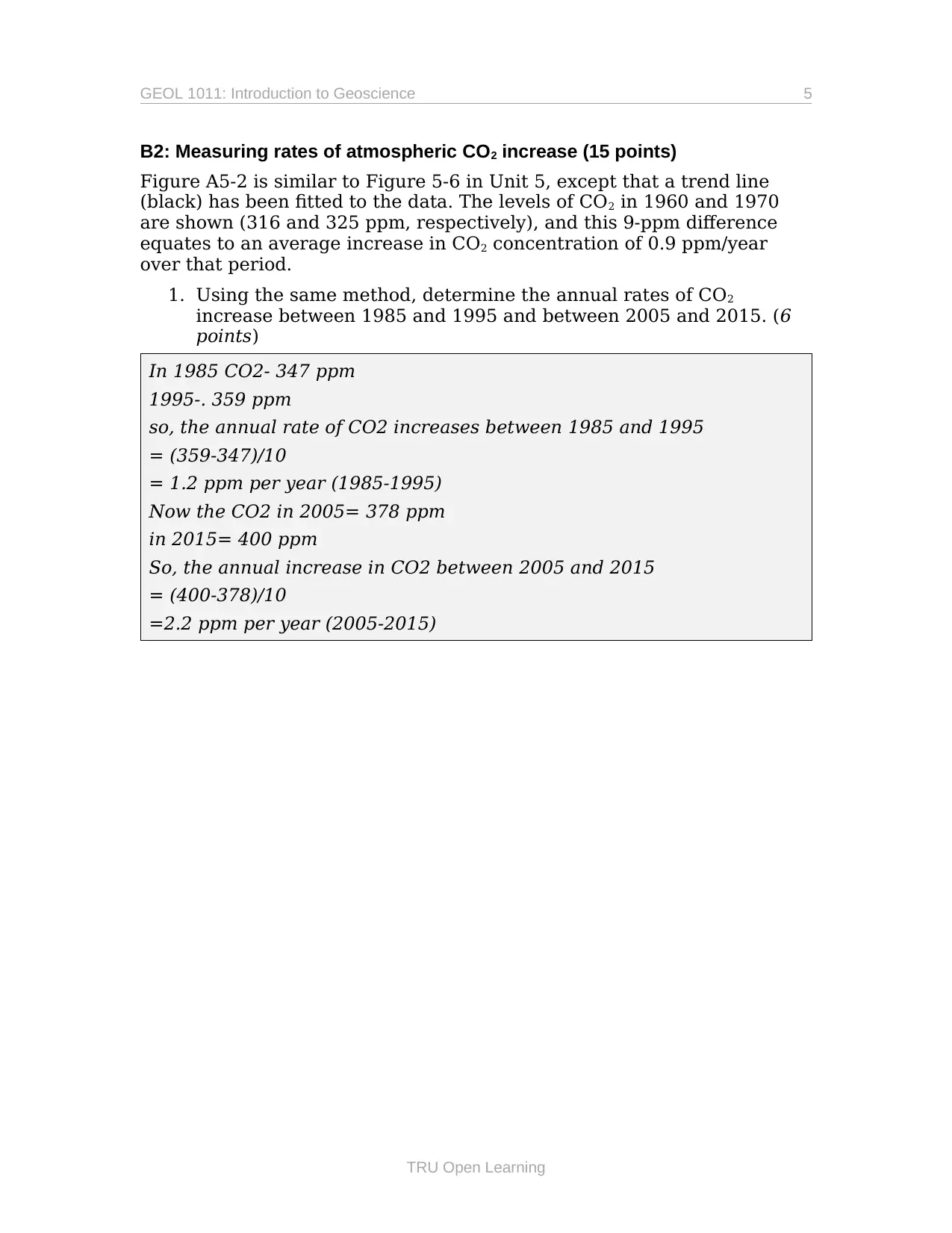
B2: Measuring rates of atmospheric CO2 increase (15 points)
Figure A5-2 is similar to Figure 5-6 in Unit 5, except that a trend line
(black) has been fitted to the data. The levels of CO2 in 1960 and 1970
are shown (316 and 325 ppm, respectively), and this 9-ppm difference
equates to an average increase in CO2 concentration of 0.9 ppm/year
over that period.
1. Using the same method, determine the annual rates of CO2
increase between 1985 and 1995 and between 2005 and 2015. (6
points)
In 1985 CO2- 347 ppm
1995-. 359 ppm
so, the annual rate of CO2 increases between 1985 and 1995
= (359-347)/10
= 1.2 ppm per year (1985-1995)
Now the CO2 in 2005= 378 ppm
in 2015= 400 ppm
So, the annual increase in CO2 between 2005 and 2015
= (400-378)/10
=2.2 ppm per year (2005-2015)
TRU Open Learning
6 Assignment 5
by Steven Earle from data at https://scripps.ucsd.edu/programs/keelingcurve/
Figure A5-2. Atmospheric CO2 concentrations as measured at the
Keeling Lab on Mauna Loa, Hawaii
2. In 1992, countries around the world (including Canada)
signed the Kyoto Protocol and committed to reducing their
CO2 emission levels. Comment on what the data in Figure
A5-2 tells us about the collective success of these
commitments. (4 points)
From the figure, the protocol failed miserably. There was a slight
change on the year but on the long run the CO2 levels have steadily
increase over time meaning the emission levels are still high and
increasing.
3. What accounts for the saw-tooth nature of the Earth’s CO2
curve (the pink line on the graph)? It may help to refer to
the inset showing the data for 1998 and 1999 in detail. (5
points)
The jagged red line is as a result of plant growth cycles which
oscillates by nature.
Human activities, such as burning of fossil fuel, creates the increases
overtime curve. The graph of Keeling's data from Mauna Loa is known
TRU Open Learning

GEOL 1011: Introduction to Geoscience 7
as the Keeling Curve.
TRU Open Learning
as the Keeling Curve.
TRU Open Learning
Paraphrase This Document
Need a fresh take? Get an instant paraphrase of this document with our AI Paraphraser
8 Assignment 5
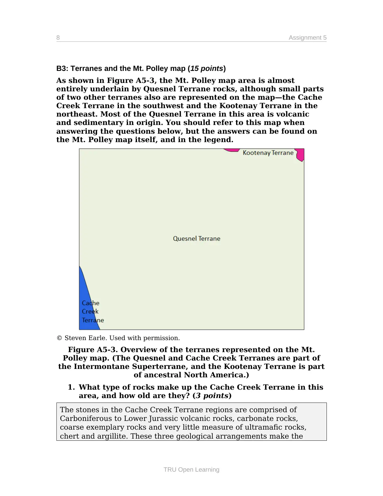
B3: Terranes and the Mt. Polley map (15 points)
As shown in Figure A5-3, the Mt. Polley map area is almost
entirely underlain by Quesnel Terrane rocks, although small parts
of two other terranes also are represented on the map—the Cache
Creek Terrane in the southwest and the Kootenay Terrane in the
northeast. Most of the Quesnel Terrane in this area is volcanic
and sedimentary in origin. You should refer to this map when
answering the questions below, but the answers can be found on
the Mt. Polley map itself, and in the legend.
© Steven Earle. Used with permission.
Figure A5-3. Overview of the terranes represented on the Mt.
Polley map. (The Quesnel and Cache Creek Terranes are part of
the Intermontane Superterrane, and the Kootenay Terrane is part
of ancestral North America.)
1. What type of rocks make up the Cache Creek Terrane in this
area, and how old are they? (3 points)
The stones in the Cache Creek Terrane regions are comprised of
Carboniferous to Lower Jurassic volcanic rocks, carbonate rocks,
coarse exemplary rocks and very little measure of ultramafic rocks,
chert and argillite. These three geological arrangements make the
TRU Open Learning
GEOL 1011: Introduction to Geoscience 9
Cache Creek Terrane complex.
The age is considered as from late Permian to early Trissac length and
has a yielded age approx. 251 Ma.
2. What type of rocks make up the Kootenay Terrane in this
area, and how old are they? (3 points)
The Kootenay rock formation is comprised of, sedimentary, mafic,
ultramafic and volcanic rocks.
Kootenay rock formation are as 1.5 billion years old, the most
established sedimentary rocks and the belt of shale, lime stone and
sand stone are considered to be 700 to 300 million years of age.
3. When the Quesnel Terrane was accreted onto North America
in the early Jurassic (at around 185 Ma), it already included
some intrusive igneous rocks, but other intrusions appeared
later. Identify the post-accretion intrusive igneous rock(s)
and indicate their age(s). (3 points)
The component petrochemistry had been resolved at 46 late Triassic to
early Jurassic rocks demonstrating the Mt Milligan and Chuchi
porphyry copper and gold stores, a few periods of Hogem Batholith and
takla bunch volcanic rocks. Monzonites and lattices of Mt Milligan
stores have solid potassium, K-feilspar and biotite.
4. Some sedimentary and volcanic rocks and some still-
unconsolidated sediments were deposited in this region after
the early Jurassic terrane accretion event. Identify these
units, and indicate their ages and the types of materials. (6
points)
TRU Open Learning
10 Assignment 5
Part C: Longer Questions (35 points in total)
Please answer the following questions. Write as much as you think
is necessary to address each question, but be as concise and clear
as possible. Feel free to use point-form or a table rather than
standard essay format. You do not need to reference the text or
the material in the Course Units (excluding images and
quotations), but if you use any outside sources, provide in-text
citations. Use any referencing style that you are comfortable with.
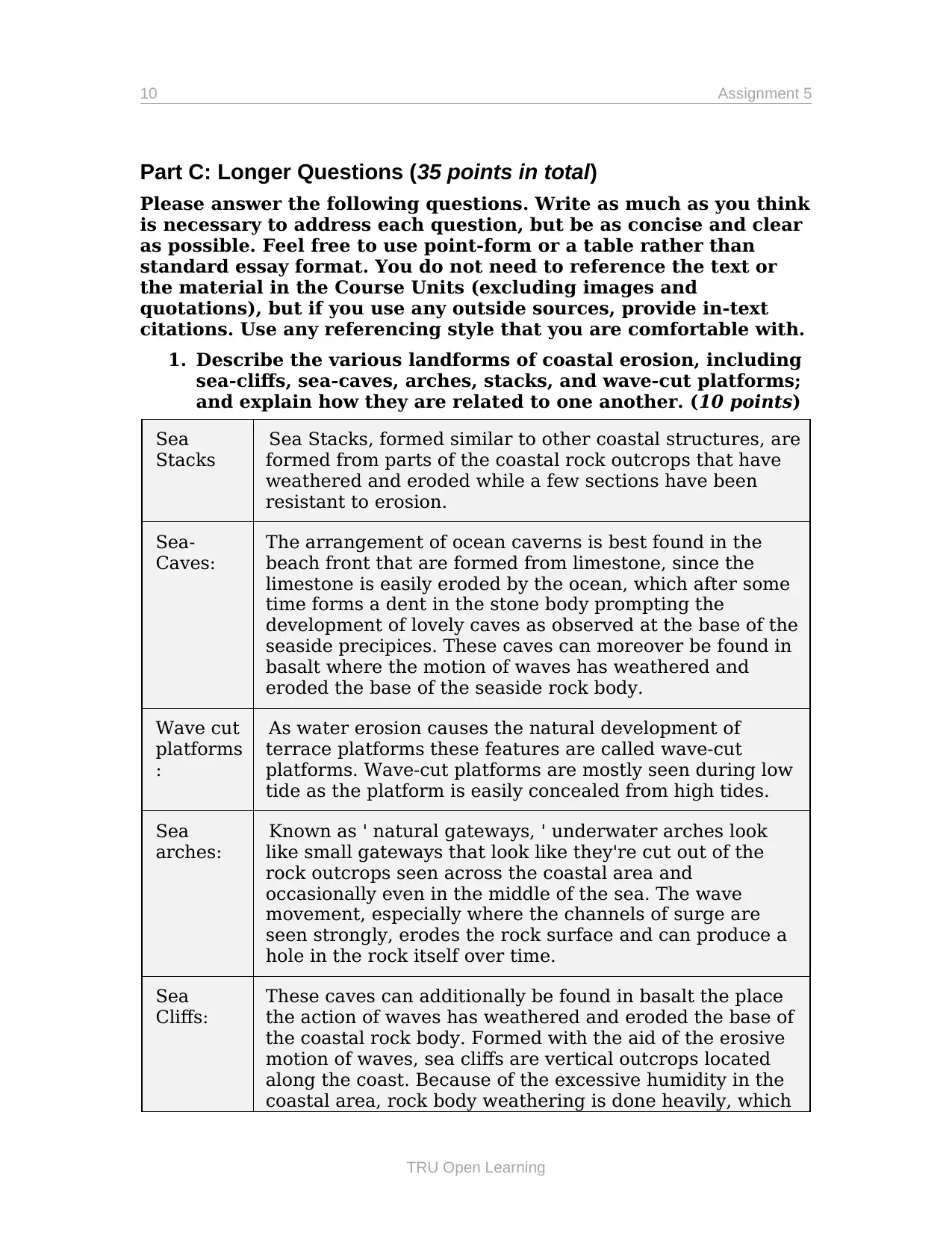
1. Describe the various landforms of coastal erosion, including
sea-cliffs, sea-caves, arches, stacks, and wave-cut platforms;
and explain how they are related to one another. (10 points)
Sea
Stacks
Sea Stacks, formed similar to other coastal structures, are
formed from parts of the coastal rock outcrops that have
weathered and eroded while a few sections have been
resistant to erosion.
Sea-
Caves:
The arrangement of ocean caverns is best found in the
beach front that are formed from limestone, since the
limestone is easily eroded by the ocean, which after some
time forms a dent in the stone body prompting the
development of lovely caves as observed at the base of the
seaside precipices. These caves can moreover be found in
basalt where the motion of waves has weathered and
eroded the base of the seaside rock body.
Wave cut
platforms
:
As water erosion causes the natural development of
terrace platforms these features are called wave-cut
platforms. Wave-cut platforms are mostly seen during low
tide as the platform is easily concealed from high tides.
Sea
arches:
Known as ' natural gateways, ' underwater arches look
like small gateways that look like they're cut out of the
rock outcrops seen across the coastal area and
occasionally even in the middle of the sea. The wave
movement, especially where the channels of surge are
seen strongly, erodes the rock surface and can produce a
hole in the rock itself over time.
Sea
Cliffs:
These caves can additionally be found in basalt the place
the action of waves has weathered and eroded the base of
the coastal rock body. Formed with the aid of the erosive
motion of waves, sea cliffs are vertical outcrops located
along the coast. Because of the excessive humidity in the
coastal area, rock body weathering is done heavily, which
TRU Open Learning
Part C: Longer Questions (35 points in total)
Please answer the following questions. Write as much as you think
is necessary to address each question, but be as concise and clear
as possible. Feel free to use point-form or a table rather than
standard essay format. You do not need to reference the text or
the material in the Course Units (excluding images and
quotations), but if you use any outside sources, provide in-text
citations. Use any referencing style that you are comfortable with.
1. Describe the various landforms of coastal erosion, including
sea-cliffs, sea-caves, arches, stacks, and wave-cut platforms;
and explain how they are related to one another. (10 points)
Sea
Stacks
Sea Stacks, formed similar to other coastal structures, are
formed from parts of the coastal rock outcrops that have
weathered and eroded while a few sections have been
resistant to erosion.
Sea-
Caves:
The arrangement of ocean caverns is best found in the
beach front that are formed from limestone, since the
limestone is easily eroded by the ocean, which after some
time forms a dent in the stone body prompting the
development of lovely caves as observed at the base of the
seaside precipices. These caves can moreover be found in
basalt where the motion of waves has weathered and
eroded the base of the seaside rock body.
Wave cut
platforms
:
As water erosion causes the natural development of
terrace platforms these features are called wave-cut
platforms. Wave-cut platforms are mostly seen during low
tide as the platform is easily concealed from high tides.
Sea
arches:
Known as ' natural gateways, ' underwater arches look
like small gateways that look like they're cut out of the
rock outcrops seen across the coastal area and
occasionally even in the middle of the sea. The wave
movement, especially where the channels of surge are
seen strongly, erodes the rock surface and can produce a
hole in the rock itself over time.
Sea
Cliffs:
These caves can additionally be found in basalt the place
the action of waves has weathered and eroded the base of
the coastal rock body. Formed with the aid of the erosive
motion of waves, sea cliffs are vertical outcrops located
along the coast. Because of the excessive humidity in the
coastal area, rock body weathering is done heavily, which
TRU Open Learning
Secure Best Marks with AI Grader
Need help grading? Try our AI Grader for instant feedback on your assignments.
GEOL 1011: Introduction to Geoscience 11
makes the uncovered rock brittle. Over time, this segment
is observed through the erosion of the weathered rock by
the motion of waves and wind, resulting in uncovered
vertical faces of the coastal rock called sea cliffs.
2. Describe how changes in ocean currents have contributed
to climate change in the past, and how climate change
might contribute to changes in ocean currents in the
future. (10 points)
There's a connection between the oceans and the atmosphere. The
sunlight that hits the earth is absorbed by the oceans, and some of it is
reflected back. The absorbed heat makes the water warm, and then the
water moves to a cold place.
This way, the water spreads the heat around the globe. These oceans
also help to maintain the levels of oxygen on Earth.
There is no pollution or global warming in the past and all is perfect.
So, the oceanic currents took the heat and dispersed the leaves of heat
and oxygen rich levels were maintained.
Many of the marine species have migrated and preserved a healthy
ecological cycle. So, the warm air evaporated on the atmosphere, and
the clouds were formed to produce enough rain.
The energy that the ocean currents bring has influenced the
atmosphere, and vice versa.
The oceanic currents and the atmospheric conditions will not be
strictly comparable in the future. It is because the two primary causes
are pollution and population.
Global warming is melting the ice, and rising sea level. The amount of
oxygen is getting depleted. The marine species die because the air is
not circulating adequately in the oceans.
All the clouds turn into acids and these are irregularly driven to the
globe. The acid rains from the atmosphere ruin the oceanic
environment at the same time. The plants are dying, more pollution to
the ocean water.
The climatic conditions will be severe in the future, and they will make
the oceanic currents more severe.
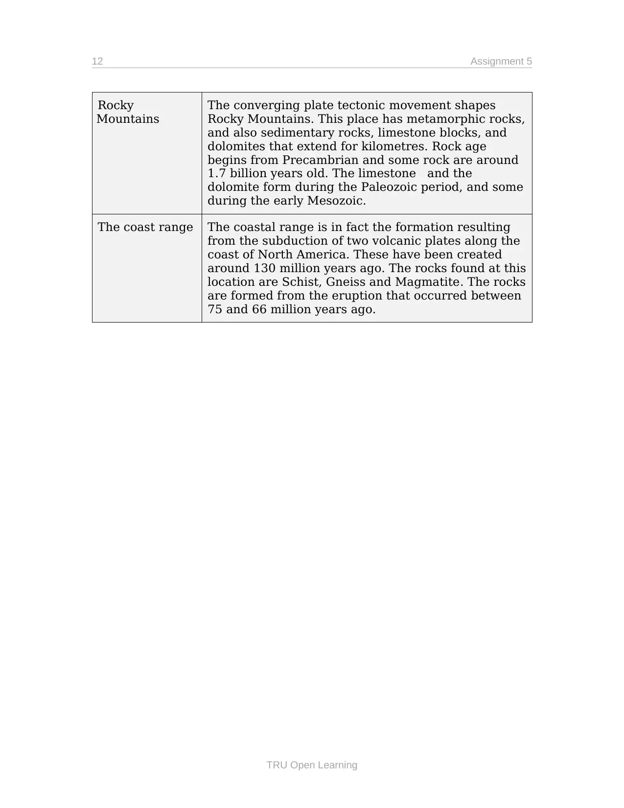
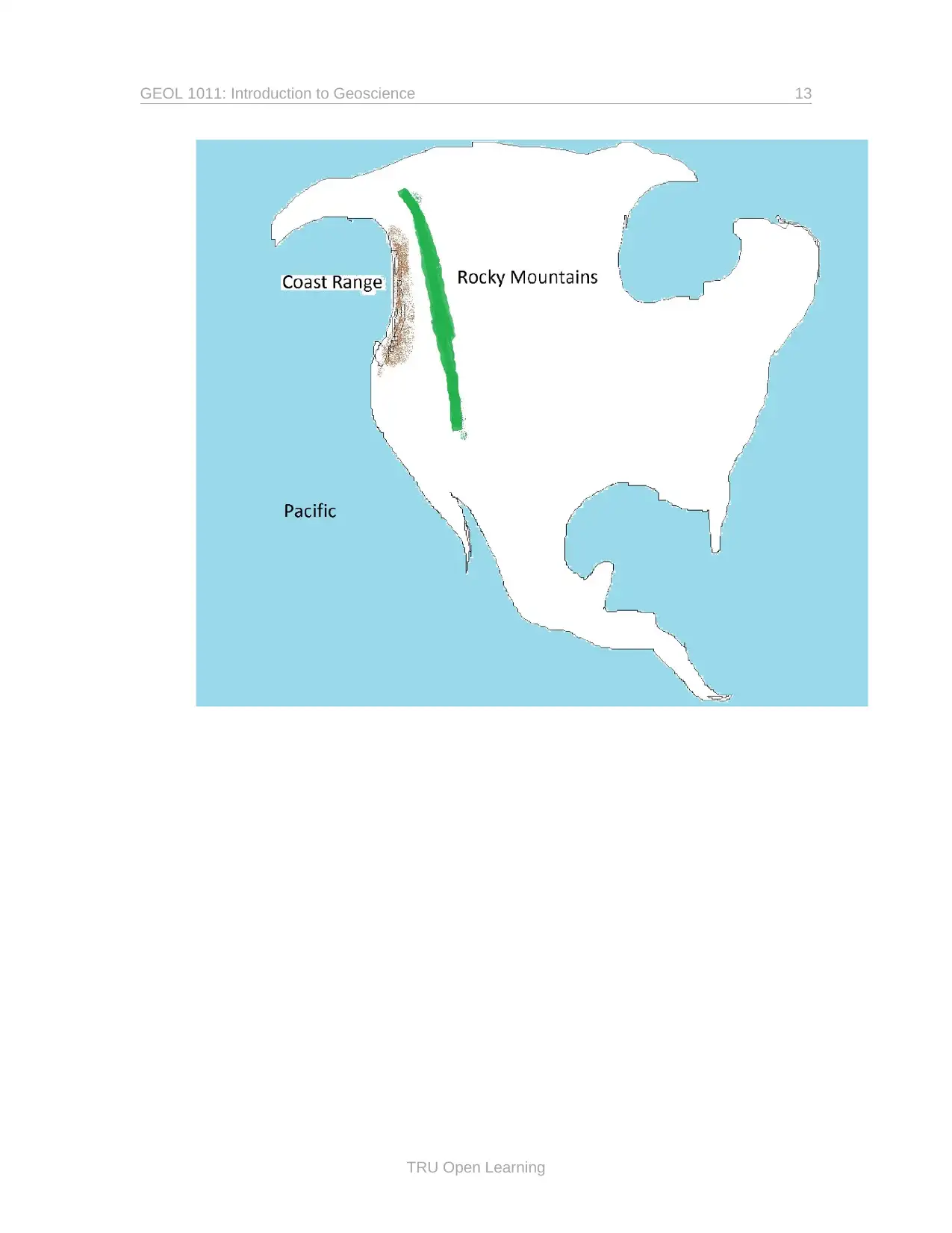
3. Western Canada’s two main mountain ranges are the Rocky
Mountains and the Coast Range. Compare these two ranges
from the perspective of their geological (tectonic) origins,
major rock types, and age. Show the approximates extents of
the Rocky Mountains and the Coast Range on the map
below. (15 points)
TRU Open Learning
makes the uncovered rock brittle. Over time, this segment
is observed through the erosion of the weathered rock by
the motion of waves and wind, resulting in uncovered
vertical faces of the coastal rock called sea cliffs.
2. Describe how changes in ocean currents have contributed
to climate change in the past, and how climate change
might contribute to changes in ocean currents in the
future. (10 points)
There's a connection between the oceans and the atmosphere. The
sunlight that hits the earth is absorbed by the oceans, and some of it is
reflected back. The absorbed heat makes the water warm, and then the
water moves to a cold place.
This way, the water spreads the heat around the globe. These oceans
also help to maintain the levels of oxygen on Earth.
There is no pollution or global warming in the past and all is perfect.
So, the oceanic currents took the heat and dispersed the leaves of heat
and oxygen rich levels were maintained.
Many of the marine species have migrated and preserved a healthy
ecological cycle. So, the warm air evaporated on the atmosphere, and
the clouds were formed to produce enough rain.
The energy that the ocean currents bring has influenced the
atmosphere, and vice versa.
The oceanic currents and the atmospheric conditions will not be
strictly comparable in the future. It is because the two primary causes
are pollution and population.
Global warming is melting the ice, and rising sea level. The amount of
oxygen is getting depleted. The marine species die because the air is
not circulating adequately in the oceans.
All the clouds turn into acids and these are irregularly driven to the
globe. The acid rains from the atmosphere ruin the oceanic
environment at the same time. The plants are dying, more pollution to
the ocean water.
The climatic conditions will be severe in the future, and they will make
the oceanic currents more severe.
3. Western Canada’s two main mountain ranges are the Rocky
Mountains and the Coast Range. Compare these two ranges
from the perspective of their geological (tectonic) origins,
major rock types, and age. Show the approximates extents of
the Rocky Mountains and the Coast Range on the map
below. (15 points)
TRU Open Learning
12 Assignment 5
Rocky
Mountains
The converging plate tectonic movement shapes
Rocky Mountains. This place has metamorphic rocks,
and also sedimentary rocks, limestone blocks, and
dolomites that extend for kilometres. Rock age
begins from Precambrian and some rock are around
1.7 billion years old. The limestone and the
dolomite form during the Paleozoic period, and some
during the early Mesozoic.
The coast range The coastal range is in fact the formation resulting
from the subduction of two volcanic plates along the
coast of North America. These have been created
around 130 million years ago. The rocks found at this
location are Schist, Gneiss and Magmatite. The rocks
are formed from the eruption that occurred between
75 and 66 million years ago.
TRU Open Learning
GEOL 1011: Introduction to Geoscience 13
TRU Open Learning
TRU Open Learning
1 out of 13
Your All-in-One AI-Powered Toolkit for Academic Success.
+13062052269
info@desklib.com
Available 24*7 on WhatsApp / Email
![[object Object]](/_next/static/media/star-bottom.7253800d.svg)
Unlock your academic potential
© 2024 | Zucol Services PVT LTD | All rights reserved.