Atmospheric Environment: Weather Forecasting Analysis and Report
VerifiedAdded on 2022/11/11
|9
|1998
|189
Report
AI Summary
This report presents an analysis of weather forecasting data for a selected region, focusing on rainfall and temperature predictions. The study examines seven rounds of the AMOS Weather Tipping Contest, comparing forecasts with actual weather data. The analysis delves into the accuracy of the forecasts, considering factors such as low-pressure systems, cloud cover, and wind patterns. The report highlights the correlation between predicted and actual weather conditions, identifying instances of accurate predictions and discrepancies. The study also explores the influence of atmospheric conditions on temperature and rainfall, providing explanations for the observed weather patterns. The conclusion summarizes the reliability of the weather forecasting skills and suggests areas for improvement in forecasting techniques. The report references relevant literature to support the analysis and conclusions.

ATMOSPHERIC ENVIRONMENT
By Name
Course
Instructor
Institution
Location
Date
By Name
Course
Instructor
Institution
Location
Date
Paraphrase This Document
Need a fresh take? Get an instant paraphrase of this document with our AI Paraphraser
Introduction
Weather forecasting starts by continuously taking note of the state of the atmosphere, surface of
the land as well as the ocean. A framework is provided by the World Meteorological
Organization for an ever changing worldwide suit of systems of observations for instance radars,
surface weather as well as satellite observations that assist with monitoring of such conditions. In
as much as extensive research challenges are still dominant; scientists have made significant
progress with regard to development of mathematical strategies used in the integration of such
observations into snapshots of atmospheric states as well as on the land surface at any provided
time (Bendre, Thool and Thool, 2015). Such analyses act as the foundation for prediction of
weather on scales from each of the clouds to regional severe weather events as well as global
patterns. Analysis of the past as well as prevailing weather is in support of numerous diverse
environmental applications such as fundamental scientific investigations of the climate system.
This study is aimed at presentation of the weather forecasting data regarding the rainfall and
temperature for a selected region and providing the possible explanations for the derived
forecasts based on available literature and various sources of data on the region (Jung and
Matsueda, 2016).
Summary of the rounds
Round 1
Week 1-
Townsvill
e
Min Max Rain Explain
Sat 1 /
23
1/30 Very
Heavy
Low pressure system as well as associated low
pressure trough after the remnants the sea breeze
still show rainfall around the region.Sun 1/24 3/32 Very
Heavy
Round 2
Week 2-
Dubbo
Min Max Rain Explain
Sat 0/0 0/0 No rain High pressure system is associated with no clouds
and nice calm weather. Relatively stable. Winds
coming across water bodies from the low will
result in cooler winds, hence limiting gains in
temperature.
Sun 3/13 0/0 No rain
Round 3
Week 3-
Halls
Creek
Airport
Min Max Rain Explain
Sat 3/16 2/38 No rain No cloud linked with top part of low pressure
system, suggests no cloud cover/precipitation in
this area.
Sun 1/19 0/37 No rain
⊘ This is a preview!⊘
Do you want full access?
Subscribe today to unlock all pages.

Trusted by 1+ million students worldwide
Round 4
Week 4-
Port
Lincoln
Airport
Min Max Rain Explain
Sat 7/12 1/32 Heavy Low pressure system as well as associated low
pressure trough after the remnants the sea breeze
still show rainfall around the region.
Sun 3/8 1/20 Heavy
Round 5
Week 5-
Mildura
Min Max Rain Explain
Sat 3/6 0/19 No rain No cloud linked with top part of low pressure
system, indicates no cloud cover or precipitation
in this area.
Sun 0/5 1/22 No rain
Round 6
Week 6-
Victoria
River
Downs
Min Max Rain Explain
Sat 3/21 0/35 No rain No cloud linked with top part of low pressure
system, indicates no cloud cover or precipitation
in this area.
Sun 7/14 1/32 No rain
Round 7
Week 7-
St. George
Min Max Rain Explain
Sat 1/3 0/18 No rain No cloud linked with top part of low pressure
system, indicates no cloud cover or precipitation
in this area.
Sun 4/8 0/21 No rain
Analysis
The rounds chosen for the analysis are rounds 1 and round 7. The two rounds are quite distinct in
their feature in which observations made in round 1 depicted the possibility of heavy rainfalls in
the region alongside very low temperatures. Round 7 on the other hand gave a prediction of no
rains even though with low temperatures just as was the case with round 1.
Paraphrase This Document
Need a fresh take? Get an instant paraphrase of this document with our AI Paraphraser
Round 1
Week 1-
Townsvill
e
Min Max Rain Explain
Sat 1 /
23
1/30 Very
Heavy
Low pressure system as well as associated low
pressure trough after the remnants the sea breeze
still show rainfall around the region.Sun 1/24 3/32 Very
Heavy
The rate of rainfall may be described as either light, moderate or heavy in which the prediction in
round 1 depicted heavy rainfall. Heavy rainfall as per this forecast defined rainfall which was
expected to be more than 0.3 inches for every hour. The increase in the temperature in the region
as well as enhanced moisture in the atmosphere was the basis of the forecast that the region was
likely to experience heavy downpours. At high moisture content in the atmopshres, the rain
bearing clouds tends to collect at a very high rate hence resulting in the forecast heavy rains.
Still, the weather looked quite with minimal movement of winds that resulted in signficnt
stability. This ensured the clouds are not spread apart as well as ensuring the temperatures are
maintained at relatively constant values (Falconer et al., 2017).
The stable winds as well ensured minimal disturbance on the surrounding temperature and hence
a forecast that the temperatures would remain quite low during the two days that were forecast.
The accuracy of the prediction against the actual weather data of the forecast days of the region
showed a correlation in the case of rainfall but minimal correlation if any for the case of the
maximum and minimum temperatures. This means that the basis of making the forecast with
regard to temperature was not accurate (Grover, Kapoor and Horvitz, 2015). The actual
minimum and maximum temperatures indicated that the region would receive relatively high
temperatures as opposed to the forecast of very low temperatures. For the case of forecast on the
rainfall, the parameters of the forecast were seemingly providing the same results as the actual
findings of the station (Schalkwijk et al., 2015). The Low pressure system as well as associated
low pressure trough after the remnants the sea breeze still show rainfall around the region as the
prediction was seemingly accurate.
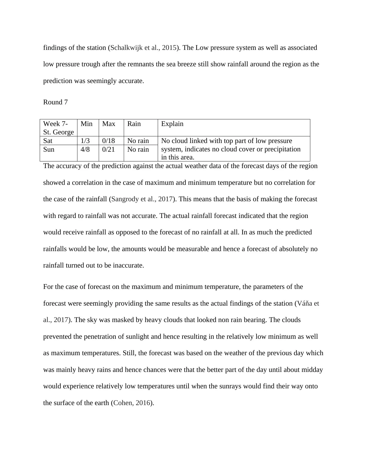
Round 7
Week 7-
St. George
Min Max Rain Explain
Sat 1/3 0/18 No rain No cloud linked with top part of low pressure
system, indicates no cloud cover or precipitation
in this area.
Sun 4/8 0/21 No rain
The accuracy of the prediction against the actual weather data of the forecast days of the region
showed a correlation in the case of maximum and minimum temperature but no correlation for
the case of the rainfall (Sangrody et al., 2017). This means that the basis of making the forecast
with regard to rainfall was not accurate. The actual rainfall forecast indicated that the region
would receive rainfall as opposed to the forecast of no rainfall at all. In as much the predicted
rainfalls would be low, the amounts would be measurable and hence a forecast of absolutely no
rainfall turned out to be inaccurate.
For the case of forecast on the maximum and minimum temperature, the parameters of the
forecast were seemingly providing the same results as the actual findings of the station (Váňa et
al., 2017). The sky was masked by heavy clouds that looked non rain bearing. The clouds
prevented the penetration of sunlight and hence resulting in the relatively low minimum as well
as maximum temperatures. Still, the forecast was based on the weather of the previous day which
was mainly heavy rains and hence chances were that the better part of the day until about midday
would experience relatively low temperatures until when the sunrays would find their way onto
the surface of the earth (Cohen, 2016).
⊘ This is a preview!⊘
Do you want full access?
Subscribe today to unlock all pages.

Trusted by 1+ million students worldwide
Light rainfall as per this forecast defined rainfall which was expected to be less than 0.1 inches
for each hour. The low in the temperature in the region as well as low moisture in the atmosphere
was the basis of the forecast that the region was likely to experience no rains. At the very low
temperatures, there is no evaporation of moisture taking place in the various water bodies hence
the relative humidity of the atmosphere tends to be reduced. At low moisture content in the
atmosphere, the sky tends to be clear or covered by clouds which are not rain bearing. Still, the
weather looked quite with minimal movement of winds that resulted in significant stability. This
ensured the clouds are not spread apart as well as ensuring the temperatures are maintained at
relatively constant values (Buehner et al., 2015). The stable winds as well ensured minimal
disturbance on the surrounding temperature and hence a forecast that the temperatures would
remain quite low during the two days that were forecast.
Conclusion
The weather forecast skills deployed in this study provided results that are partly reliable and
party inaccurate as determined by the actual weather of the various stations. While the forecast
predicted very low minimum and maximum temperatures in as well as heavy rainfalls for round
one, the actual results showed high minimum and maximum temperatures and heavy downpours
making the rainfall forecasting bit accurate and reliable. Round 7 forecast were low temperatures
(minimum and maximum) as well no rainfalls due to predicted low rate of evaporation of eater
from the water bodies. The actual conditions of the station were low minimum and maximum
temperatures and no rainfalls. The rainfall forecast bit for this round was hence inaccurate and
required enhancement in the forecasting skills.
Paraphrase This Document
Need a fresh take? Get an instant paraphrase of this document with our AI Paraphraser
References
Bendre, M.R., Thool, R.C. and Thool, V.R., 2015, September. Big data in precision agriculture:
Weather forecasting for future farming. In 2015 1st International Conference on Next
Generation Computing Technologies (NGCT) (pp. 744-750). IEEE
Buehner, M., McTaggart-Cowan, R., Beaulne, A., Charette, C., Garand, L., Heilliette, S.,
Lapalme, E., Laroche, S., Macpherson, S.R., Morneau, J. and Zadra, A., 2015. Implementation
of deterministic weather forecasting systems based on ensemble–variational data assimilation at
Environment Canada. Part I: The global system. Monthly Weather Review, 143(7), pp.2532-2559
Cohen, J., 2016. Weather forecasting: El Nino dons winter disguise as La
Nina. Nature, 533(7602), p.179
Falconer, D., Barghouty, N., Zavodsky, B. and Khazanov, I., 2017. An All-Clear Space Weather
Forecasting System Based on Near Real Time Magnetograms
Grover, A., Kapoor, A. and Horvitz, E., 2015, August. A deep hybrid model for weather
forecasting. In Proceedings of the 21th ACM SIGKDD International Conference on Knowledge
Discovery and Data Mining (pp. 379-386). ACM
Jung, T. and Matsueda, M., 2016. Verification of global numerical weather forecasting systems
in polar regions using TIGGE data. Quarterly Journal of the Royal Meteorological
Society, 142(695), pp.574-582
Sangrody, H., Sarailoo, M., Zhou, N., Tran, N., Motalleb, M. and Foruzan, E., 2017. Weather
forecasting error in solar energy forecasting. IET Renewable Power Generation, 11(10),
pp.1274-1280
Schalkwijk, J., Jonker, H.J., Siebesma, A.P. and Van Meijgaard, E., 2015. Weather forecasting
using GPU-based large-eddy simulations. Bulletin of the American Meteorological
Society, 96(5), pp.715-723
Váňa, F., Düben, P., Lang, S., Palmer, T., Leutbecher, M., Salmond, D. and Carver, G., 2017.
Single precision in weather forecasting models: An evaluation with the IFS. Monthly Weather
Review, 145(2), pp.495-502
⊘ This is a preview!⊘
Do you want full access?
Subscribe today to unlock all pages.

Trusted by 1+ million students worldwide
1 out of 9
Your All-in-One AI-Powered Toolkit for Academic Success.
+13062052269
info@desklib.com
Available 24*7 on WhatsApp / Email
![[object Object]](/_next/static/media/star-bottom.7253800d.svg)
Unlock your academic potential
Copyright © 2020–2026 A2Z Services. All Rights Reserved. Developed and managed by ZUCOL.