Comparative Geography: Analysis of Richmond and Surrey Sub-areas
Added on 2023-06-03
14 Pages2686 Words75 Views
Surname 1
Name
Instructor
Human Geography
October 16, 2018
Comparative Geography:
Introduction
The City of Vancouver is a waterfront, seaport city on the terrain of British Columbia.
Situated on the western portion of the Burrard Peninsula, Vancouver is limited toward the north
by English Bay and the Burrard Inlet and toward the south by the Fraser River. Bone (73) stated
that, Metro Vancouver city comprises of a confederacy of 22 cities, one electoral area and one
treaty first nation. Some of these cities include; Abbotsford, Surrey, city of Vancouver, village of
Lions Bay, Langley, Coquitlam, maple Ridge, Burnaby, Richmond, corporation of Delta, Bowen
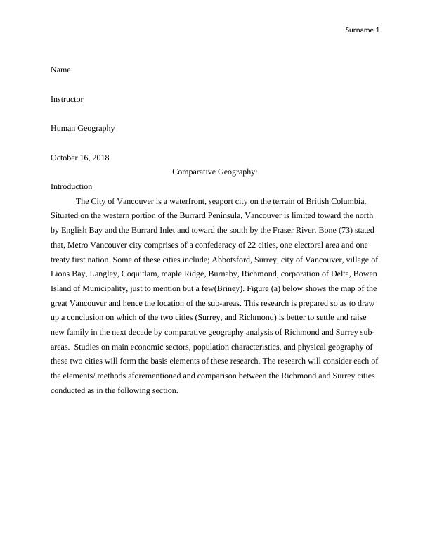
Island of Municipality, just to mention but a few(Briney). Figure (a) below shows the map of the
great Vancouver and hence the location of the sub-areas. This research is prepared so as to draw
up a conclusion on which of the two cities (Surrey, and Richmond) is better to settle and raise
new family in the next decade by comparative geography analysis of Richmond and Surrey sub-
areas. Studies on main economic sectors, population characteristics, and physical geography of
these two cities will form the basis elements of these research. The research will consider each of
the elements/ methods aforementioned and comparison between the Richmond and Surrey cities
conducted as in the following section.
Name
Instructor
Human Geography
October 16, 2018
Comparative Geography:
Introduction
The City of Vancouver is a waterfront, seaport city on the terrain of British Columbia.
Situated on the western portion of the Burrard Peninsula, Vancouver is limited toward the north
by English Bay and the Burrard Inlet and toward the south by the Fraser River. Bone (73) stated
that, Metro Vancouver city comprises of a confederacy of 22 cities, one electoral area and one
treaty first nation. Some of these cities include; Abbotsford, Surrey, city of Vancouver, village of
Lions Bay, Langley, Coquitlam, maple Ridge, Burnaby, Richmond, corporation of Delta, Bowen
Island of Municipality, just to mention but a few(Briney). Figure (a) below shows the map of the
great Vancouver and hence the location of the sub-areas. This research is prepared so as to draw
up a conclusion on which of the two cities (Surrey, and Richmond) is better to settle and raise
new family in the next decade by comparative geography analysis of Richmond and Surrey sub-
areas. Studies on main economic sectors, population characteristics, and physical geography of
these two cities will form the basis elements of these research. The research will consider each of
the elements/ methods aforementioned and comparison between the Richmond and Surrey cities
conducted as in the following section.
Surname 2
Figure (a) Greater Vancouver, Canada.
Methods 1:
Physical geography
In "Physical Geography | Geography 250", physical geography is defined as the sub-
branch of Geography which entails the study of the spatial characteristics of the various natural
phenomena occurring on the earth; patterns and processes of natural environment. Physical
geography manifestations includes hydrological cycle, occurrence of seasons, soils, climate
zones, streams and rivers, coastal terrain ecosystem etc. these features of physical geography
tend to define civilizations and settlement characteristics. Lefringhausen and Marshall (50)
records that civilizations around places with mountains, hike spots, swimming and fishing waters
attract individuals keen on recreational activities and alike such as hiking, mountain climbing,
fishing etc. On the other hand civilization of people inhabiting flat terrain and flat fertile soil
regions tend to lean towards agriculture and farming, commerce etc.
Results
Richmond is positioned at the head of the passable part of the James River sandwiched
between Virginia's coastal plains and the Piedmont, beyond which are the Blue Ridge
Mountains. It covers an area of 62.55 square miles and occurs at 312 feet above the seal level
Surname 3
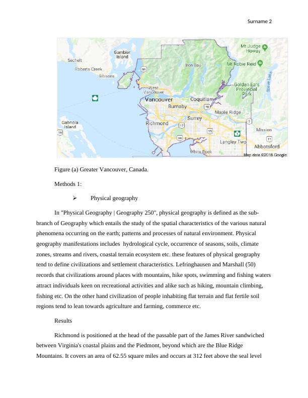
with average temperatures 36.6 Farads in January, 77.9 Farads in July and an annual average
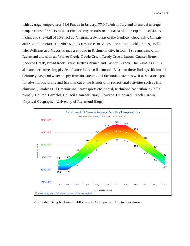
temperatures of 57.7 Farads. Richmond city records an annual rainfall precipitation of 43.13
inches and snowfall of 16.9 inches (Virginia. a Synopsis of the Geology, Geography, Climate
and Soil of the State, Together with Its Resources of Mines, Forests and Fields, Etc. 9). Belle
Isle, Williams and Mayos Islands are found in Richmond city. In total, 8 streams pass within
Richmond city such as; Walker Creek, Goode Creek, Reedy Creek, Bacons Quarter Branch,
Shockoe Creek, Broad Rock Creek, Jordans Branch and Cannon Branch. The Gambles Hill is
also another interesting physical feature found in Richmond. Based on these findings, Richmond
definitely has good water supply from the streams and the Jordan River as well as vacation spots
for adventurous family and fun time out at the Islands or in recreational activities such as Hill
climbing (Gambles Hill), swimming, water sports etc.in total, Richmond has within it 7 hills
namely: Church, Gambles, Council Chamber, Navy, Shockoe, Union and French Garden
(Physical Geography - University of Richmond Blogs).
Figure depicting Richmond Hill Canada Average monthly temperatures
with average temperatures 36.6 Farads in January, 77.9 Farads in July and an annual average
temperatures of 57.7 Farads. Richmond city records an annual rainfall precipitation of 43.13
inches and snowfall of 16.9 inches (Virginia. a Synopsis of the Geology, Geography, Climate
and Soil of the State, Together with Its Resources of Mines, Forests and Fields, Etc. 9). Belle
Isle, Williams and Mayos Islands are found in Richmond city. In total, 8 streams pass within
Richmond city such as; Walker Creek, Goode Creek, Reedy Creek, Bacons Quarter Branch,
Shockoe Creek, Broad Rock Creek, Jordans Branch and Cannon Branch. The Gambles Hill is
also another interesting physical feature found in Richmond. Based on these findings, Richmond
definitely has good water supply from the streams and the Jordan River as well as vacation spots
for adventurous family and fun time out at the Islands or in recreational activities such as Hill
climbing (Gambles Hill), swimming, water sports etc.in total, Richmond has within it 7 hills
namely: Church, Gambles, Council Chamber, Navy, Shockoe, Union and French Garden
(Physical Geography - University of Richmond Blogs).
Figure depicting Richmond Hill Canada Average monthly temperatures
Surname 4
Figure showing average monthly rainfall in Richmond.
Surrey is bordered by a number of communities such as Langley to the East, Delta to the
West, and to the south lies the White Rock. Surrey is bounded by notably the longest river in
British Columbia, the Fraser River. Two hour drive southwards from Surrey borders lies Seattle
(major city in America). Approximately 6000 acres of land in surrey are designated parklands.
According to Briney, A lot of green space is available in Surrey compared to any sub area with
the metro Vancouver community. Surrey comprises of beaches, plenty of land for agriculture, a
number forest covers and the terrain is relatively flat. Also, Serpentine River and Nicomekl
Rivers runs through Surrey. Surrey is located in coastal temperature rainforest zone with average
temperatures of 22/72 farads during summer and 5/41 Farads in winter and an estimated average
temperature of 41 inches (Virginia. a Synopsis of the Geology, Geography, Climate and Soil of
the State, Together with Its Resources of Mines, Forests and Fields, Etc. 14). Surrey hence
provides a suitable destination for family homes and open environment with suitable climate
characteristics. Its proximity to Seattle makes in accessible and the extensive green space in quite
inviting.
End of preview
Want to access all the pages? Upload your documents or become a member.