Survey of Wireless Sensor Network Infrastructure in Agriculture
VerifiedAdded on 2022/10/01
|6
|6431
|5
Report
AI Summary
This paper presents a survey on wireless sensor network (WSN) infrastructure for agriculture. It introduces the concept of a hybrid WSN, which combines terrestrial WSNs with wireless underground sensor networks (WUSNs). The paper details the architecture, deployment, and operation of such hybrid systems. Experimental results are presented, focusing on the impact of soil moisture and signal frequency on radio signal path loss in WUSNs, determining optimal node deployment depths for effective data transmission. The survey explores existing WSN techniques in agricultural environments, covering applications like irrigation, crop monitoring, and fertilizer management. It also addresses the challenges and potential of WUSNs, emphasizing their potential in various fields. The paper includes a review of related works, discussing various WSN applications in agriculture and the importance of WUSNs for underground monitoring.
A survey on wireless sensor network infrastructure for agriculture
Xiaoqing Yua,
⁎, Pute Wu a, b, c
, Wenting Hana, b, c
, Zenglin Zhanga, c
a Northwest Agriculture and Forestry University,Shaanxi,Yangling,712100,China
b National Engineering Research Center for Water Saving Irrigation at Yangling, Institute of Soil and Water Conservation of Chinese Academy of Sciences, Shaanxi, Yangling,
c Research Institute of Water-saving Agriculture of Arid Regions of China,Shaanxi,Yangling,712100,China
a b s t r a c ta r t i c l e i n f o
Article history:
Received 26 February 2012
Accepted 11 May 2012
Available online 18 May 2012
Keywords:
Hybrid wireless sensor network
Information collection
Agriculture
Wireless underground sensor network
Monitoring
The hybrid wireless sensor network is a promising application of wireless sensor networking techniques. The
main difference between a hybrid WSN and a terrestrial wireless sensor network is the wireless undergroun
sensor network, which communicates in the soil. In this paper, a hybrid wireless sensor network architecture
is introduced.The framework to deploy and operate a hybrid WSN is developed.Experiments were con-
ducted using a soil that was 50% sand, 35% silt, and 15% clay; it had a bulk density of 1.5 g/cm3 and a specific
density of 2.6 cm−3 . The experiment was conducted for several soil moistures (5,10, 15, 20 and 25%) and
three signal frequencies (433, 868 and 915 MHz). The results show that the radio signal path loss is smalles
for low frequency signals and low moisture soils.Furthermore,the node deployment depth affected signal
attenuation for the 433 MHz signal. The best node deployment depth for effective transmission in a wireless
underground sensor network was determined.
© 2012 Elsevier B.V.All rights reserved.
1. Introduction
The environmentalparameters ofsoil can be viewed as a type
of spatial and three-dimensionalnetwork information.Developing
methods to gather, process, integrate and apply environmental
information is the focus of agricultural environment information
technology and contemporary international agricultural science and
technology research.Because agriculturalregions are scattered and
thus the terrains and environmentalconditions vary significantly,
methods to collect crop growth environment variable information ac-
curately and rapidly are one of the primary problems for agricultural
environment information technology research [1].
Wireless sensor network (WSN) technology has emerged as the
technical means to solve the problem.A wireless sensor network in
an agriculturalenvironment comprises integrated sensors deployed
in the area of the farmland. These sensors cooperate with each
other to perceive and monitor real-time soil and weather infor-
mation.The information is processed intelligently by an embedded
system. Moreover, the information is transmitted to a diagnosis deci-
sion center by a random self-organized wireless communication net-
work, which provides remote monitoring and management ofthe
agriculturalenvironment.Recently,wireless sensor networks have
been extensively developed for agricultural environments [2,3].The
networks have been used for irrigation, cultivation, fertilizer manage-
ment, etc.
Most wireless sensor networks developed for agricultural applica-
tions that involve soil monitoring are terrestrial wireless sensor net-
work systems.To avoid transmitting information through the soil,
the wireless sensor network is often connected by cables to data ac-
cess and wireless transceiver devices on the ground.These devices
are exposed and thus influence farming activities.In addition,trans-
mission from wireless nodes can be affected by natural geographical
and meteorologicalfactors.Wireless underground sensor networks
(WUSN) provide a new method for underground monitoring [4–6]
and have become a new topic for research in the field of agricultural
environment information technology.
Wireless underground sensor networks are sensor networks that
comprise wireless underground sensor devices,which send and re-
ceive functional modules in the soil. These devices are located at spe-
cific soil depths and wirelessly transmit data.When the induction
module perceives data,the sensor network completes the process of
data perception and collection. The sensor network has several
merits: strong concealment,ease of deployment,timeliness of data,
reliability, and potential for coverage density. In addition to monitor-
ing static parameters ofthe soil, the wireless underground sensor
network can monitor soil motion such as landslides, earthquakes, de-
bris flow, movement of underground ice and volcanic eruptions [3].
Therefore, wireless underground sensor networks have the potential
for wide application in fields such as agriculture, military, transporta-
tion, structural engineering, and earth science [7,8].
Terrestrial wireless sensor networks in irrigation control systems
have been extensively developed and researched.However, the
wireless underground sensor network is a new research area without
definitive results [9,10].In a hybrid WSN, a WSN and a WUSN are
Computer Standards & Interfaces 35 (2013) 59–64
⁎ Corresponding author.
E-mail address: yuxiaoqing115@gmail.com (X.Yu).
0920-5489/$ – see front matter © 2012 Elsevier B.V.All rights reserved.
doi:10.1016/j.csi.2012.05.001
Contents lists available at SciVerse ScienceDirect
Computer Standards & Interfaces
j o u r n a lh o m e p a g e : w w w . e l s e v i e r . c o m / l o c a t e / c s i
Paraphrase This Document
Need a fresh take? Get an instant paraphrase of this document with our AI Paraphraser
combined to form a WSN of mixed structure.The application of
hybrid WSNs to the monitoring of agriculture information is a novel
research topic.
The remainder of the paper is organized as follows. We provide an
overview of existing wireless sensor network techniques in Section 2.
The system architecture for the hybrid wireless sensor network is
presented in Section 3. In Section 4, the deployment and connectivity
of nodes are discussed.The experimentalsetup of a WUSN and its
analysis are described in Section 5.Finally,the paper is concluded in
Section 6.
2. Existing wireless sensor network techniques
2.1.Wireless sensor networks that monitor agricultural environments
Recently, wireless sensor networks have been deployed in agricul-
tural environments.Applications include the management of water
resources and productstorage facilities,the determination of the
optimal time for crop harvest,the characterization ofcrop growth
and the prediction of fertilizer requirements.
In [11], a wireless sensor network was deployed to monitor the
water content,temperature and salinity of soil at a cabbage farm lo-
cated in Murcia, a semi-arid region of Spain. The wireless sensor net-
work deployed four types of structure nodes:soil, environmental,
water and gateway.The software and hardware components of each
node were fully described.The management and monitoring of the
system were performed by a central processing computer located in
the farm's management office.The system was tested in two stages:
a laboratory test and a field test.The purpose of the laboratory test
was to analyze the functionality of the system devices and to measure
the network's performance and energy consumption.The field test
assessed the range,robustness and reliability of the system.
In [12], the temperatures at various positions in a feed warehouse
were monitored using a wireless sensor network. The communication
frequency of the sensor nodes was 433 MHz,and the transmission
power was 10 mW. The results showed that temperature sensor
nodes buried at depths of 25 and 50 cm reliably transmitted temper-
ature signals to the gateway node; between 98.9% and 99.4% of the
signals were received by the gateway node.The data obtained from
monitoring were used to develop a model of the temperature at dif-
ferent positions in the feed storehouse; the accuracy ofthe model
predictions is between 90.0% and 94.3%.
The energy limitations of wireless sensor networks were the focus
of [13].The number of nodes and the characteristics of the regional
distribution were used to determine reasonable clusters and the
communication's energy model.A theoretical analysis of the optimi-
zation of the number of clusters according to the different levels of
clusters was performed and experimentally verified.A wireless sen-
sor network was deployed to monitor a greenhouse environment in
[14].The control terminal of the system was designed based on the
ARM9 and an embedded Linux operating system,which was used
for data receiving, real-time display and data storage. The control ter-
minal communicated with the remote managementcenter using
GPRS. The wireless sensor network acquired the greenhouse environ-
ment data. The sensor network measured temperature, humidity, CO2
content,light intensity,substrate temperature and the humidity of
the greenhouse using 6 channels.
A greenhouse wireless monitoring system was designed in [15]
using a wireless sensor network based on ZigBee. A dynamic wireless
sensor network with a star topology was proposed according to the
structure characteristics ofthe greenhouse.This low cost and low
power consumption design shortens the peer-to-peer communica-
tion distance by using mobile sink nodes to form a subnet with
child nodes based on time and frequency hopping methods.A com-
plex communication network based on the low power radio frequen-
cy chip NRF2401A was developed using the method of frame
expansion.The communication algorithmsof the sensor, control
node and sink node were given.An energy consumption analysis of
the network child nodes was conducted using different working
states of the sink node.
A node system designed for the collection of farmland information
using a WSN was presented in [16].This study combined wireless
sensor network nodes and sink nodes with an embedded processor
system. The network nodes were distributed regularly over the mon-
itored region and collected soil moisture data. The nodes formed the
network and transmitted the information to the sink nodes for dy-
namic display and storage.Severalpossible node antenna heights
were considered: 0.5,1.0,1.5 and 2.0 m.To study the transmission
distance of the radio signal in different growth periods,experiments
were conducted during three typical growth periods of wheat:
seeding, jointing and heading. The relationship between the effective
transmission distance of the radio signal in different growth periods
of wheat and the optimal antenna height was found.The results of
this research provide technical support for the application of wireless
sensor networks in agriculture.
A wireless sensor network was applied to water-saving irrigation
systems in [17].A two-layer wireless sensor network was designed
based on irrigation needs and the characteristics of a fixed pipeline
spray irrigation system.An expression for the minimum number of
sensors required to cover the field was obtained using the relation-
ship between the sensing radius of each sensor and the range of the
shower nozzle. The data transmission method, the network structure
and the division of nodes were given. The reliability of the data trans-
mission was ensured using a layered fault diagnosis method.
2.2.Wireless underground sensor networks
Wireless underground sensor networks are a new research area.
At present,such networks are in the experimental study phase,and
no mature products are in the market.Little information has been
published on wireless underground sensor networks in agricultural
environments.The present work studies the dependence of path
loss, bit error rate and maximum transmission distance of the electro-
magnetic wave on factors such as soil type, volumetric water content
of the soil, deployment depth of nodes, internodes distance, the range
of frequency, etc.
A network system structure for a wireless underground sensor
network system designed as an intelligent transportation system for
the maintenance of the near surface soil(such as golf courses and
football fields) was designed in [13]. The software and hardware sys-
tems of the nodes were also designed.The collection nodes used a
low performance microcontroller. The receiving nodes on the ground
used a high performance microcontroller. However, development and
testing of the network system were not carried out.In addition,[13]
studied the performance of wireless underground sensor networks
that are influenced by the propagation of electromagnetic waves in
soil using the underground channel model,electrical characteristics
of soil and deployed solutions of wireless underground sensor net-
work nodes. Mathematical simulations were performed using
MATLAB for a system given as follows: 400 MHz signals, a sensor de-
ployment depth of 0.5 m, horizontal spacing between sensors of 1 m,
conductivity setto 0.1 and a dielectric constantof 10 under. The
transmission parameters of electromagnetic waves and energy losses
for different volumetric water contents of the soil and different sand
and clay soil compositions were studied.
In the laboratory of [18],wireless signal attenuation of a ZigBee
wireless transceiver module (Soilnet) with a 2.44 GHz carrier fre-
quency was researched using soilcolumns of different soil types
and water contents.Experimentalresults showed that increases in
the soil column depth and volumetric water content of the soilin-
creased the signal attenuation.The relationship was expressed using
60 X. Yu et al./ Computer Standards & Interfaces 35 (2013) 59–64
a linear model,and the correlation coefficient,R2, was greater than
0.90.
The near surface wireless underground sensor network system
used for golf courses was developed and the acquisition nodes,relay
nodes and gateway node were designed in [19].Each underground
acquisition node comprises a soil moisture sensor, controller, wireless
transceiver (Nordic NRF905,frequency 868 MHz),antenna,memory
unit and battery power module.Each collection node can connect
with several moisture sensors.Sink nodes are acquisition nodes
with no sensors that collect the data from acquisition nodes.Sink
nodes can communicate with other sink nodes and gateway nodes
in the routing algorithm. Gateway nodes controldata storage and
the transmission of sink nodes and connect with a computer or
GPRS module using a RS232 interface.A gateway node can connect
with 31 sink nodes simultaneously, and it can be controlled remotely
and visited through DDI as sink nodes. Experimental results indicated
that the system operated normally, and soil moisture data at the dif-
ferent depths were transmitted to the centralcomputer stably and
accurately.
In [20],Agnelo R and Silva studied how the communication per-
formance between terrestrial and underground nodes was impacted
by factors such as the antenna bandwidth of the WSN nodes in the
433 MHz frequency,the depth at which nodes are buried in the soil
(15 and 35 cm) and the water content of the soil (volumetric water
content was 9.5% and 37.3%).The field experiment showed that the
ultra-wideband antenna increased the communication range of the
original antennas by more than 350%.The transmission distance
dropped by 70% when the volumetric water content increased from
9.5% to 37.3%.When the deployment depth ofthe nodes changed
from 35 cm to 15 cm,the transmission distance of the signal for the
terrestrial nodes to the underground nodes (downlink transmission)
increased three times, and the transmission distance of the signal for
the underground nodes to the terrestrial nodes (uplink transmission)
only increased 0.4 times.
A center pivot sprayer was combined with wireless sensor net-
work nodes with a commercial full-wave 433 MHz magnetic antenna
for the precise irrigation of corn in [20]. Eight underground sensor ac-
quisition nodes (at a depth of 35–40 cm) were deployed circularly
within the operationalrange of the sprayer,and a signal receiving
node (2.5 m from the ground level) was installed in the sprayer.In
this paper,the influence of ground cover,corn canopy and the rota-
tion speed of the sprayer on receiving information was analyzed.
In [21], distortion of the acquisition signal of the soil's moisture
was greatly impacted by rainfall and stormy weather conditions,
soil compactness,soil density,vegetation cover,topology structure
parameters ofthe wireless underground sensor network,sampling
time and sampling density.
Mehmet C.Vuran studied the channelmodel of wireless sensor
network electromagnetic wave transmission in soil in [21].He ana-
lyzed path loss,bit error ratio,maximum transmission distance and
the water content test error ofelectromagnetic wave transmission
under variable conditions,such as the composition of the soil,volu-
metric water content of the soil (5%–25%),node deployment depth
(0.1 m–2 m), internode distance (0.5 m–5 m), and frequency
(300 MHz–900 MHz). The signal attenuation and antenna size results
showed that frequencies between 300 MHz and 400 MHz were more
suitable for wireless underground sensor networks. Because the
transmission distance was influenced by the deployment depth,no
one frequency is the optimum, and WUSNs based on many frequency
cognitive radio techniquesare more adaptable to environmental
changes.For networks that have shallow nodes, the double path
channelmodel can be used.The single path channelmodel can be
used for networks that have deeply buried nodes. The topology struc-
ture of the sensor networks can be designed according to the node
deploymentdepth. The maximum transmission distance was 5 m
under the 300 MHz–400 MHz frequency.Therefore,multiple hop
transmissions are suitable in the WUSN. Soil water content had a sig-
nificant influence on the performance ofthe networks.The WUSN
must be more robust to changes in water content to be suitable for
monitoring soil parameters.The performance of the wireless sensor
network was also affected by seasonalenvironment changes; cross
layer communication methods might solve this problem.
3. System architecture
An information collection system uses sensors to collect soil infor-
mation,including temperature and water content.To collect soil in-
formation,the WSN uses the CC2430 wireless transceiver module
based on the ZigBee agreement. The WUSN uses the nRF905 wireless
chip to collect and transmit information.
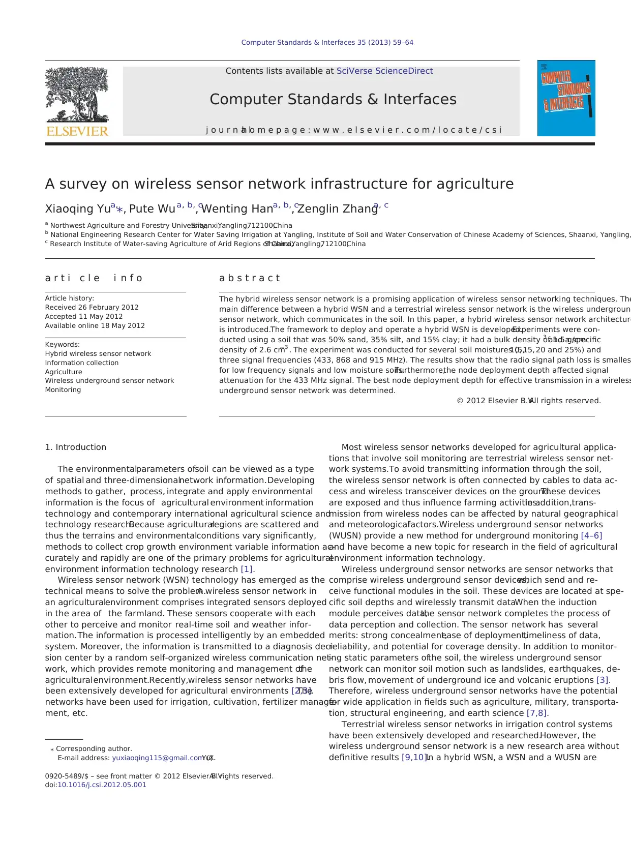
The wireless sensor node was designed using a modular design
method.The architecture of the terrestrialWSN is shown in Fig. 1.
The WUSN uses a nRF905 wireless chip instead of a CC2430 RF chip.
Each node comprises a sensor module,processor module,wireless
communication module and energy supply module.
The network topology structure is the foundation of the network.
A good network topology structure should consider the specific appli-
cation and have a simple, reliable and effective implementation
[22–24]. The proposed design combines the terrestrialand under-
ground wireless sensor network structures.A traditional WSN is
adopted above depths of 40 cm, and a WUSN is adopted below depths
of 40 cm.The sink node of the WUSN is on the ground.All nodes in
the WUSN will transmit data to the terrestrial sink node, which better
conceals the network.The location of a WUSN node depends on the
specific application. It can be located at the same depth, at a different
depth or as a different layer.The sink node can be fixed or movable
but must remain in the range of communication.The topological
structure is shown in Fig. 2.
4. Deployment and connectivity of nodes
To monitor the water content of the soil in real time, signal acqui-
sition nodes are buried in and below the cultivate layer.The hybrid
wireless sensor network node and sensor are deployed as shown in
Fig. 3.
The unique channelcharacteristics and heterogeneous network
architecture ofthe WUSN complicate the connectivity analysis.In
particular, there are three communication channels, based on the lo-
cations of the transmitter and the receiver, in a WUSN: underground-
to-underground,underground-to-aboveground,and aboveground-
to-underground.
As shown in Fig. 4, a WUSN comprises underground sensors
deployed in the sensing field, fixed aboveground data sinks set around
Various
sensors AD/
DA
CC2430
/nRF905
RF chip
CPU
Storage
Sensing Model
Processing Model Communication model
Network
MAC
Power Model
Fig. 1. Architecture of the wireless sensor network node.
61X. Yu et al./ Computer Standards & Interfaces 35 (2013) 59–64
0.90.
The near surface wireless underground sensor network system
used for golf courses was developed and the acquisition nodes,relay
nodes and gateway node were designed in [19].Each underground
acquisition node comprises a soil moisture sensor, controller, wireless
transceiver (Nordic NRF905,frequency 868 MHz),antenna,memory
unit and battery power module.Each collection node can connect
with several moisture sensors.Sink nodes are acquisition nodes
with no sensors that collect the data from acquisition nodes.Sink
nodes can communicate with other sink nodes and gateway nodes
in the routing algorithm. Gateway nodes controldata storage and
the transmission of sink nodes and connect with a computer or
GPRS module using a RS232 interface.A gateway node can connect
with 31 sink nodes simultaneously, and it can be controlled remotely
and visited through DDI as sink nodes. Experimental results indicated
that the system operated normally, and soil moisture data at the dif-
ferent depths were transmitted to the centralcomputer stably and
accurately.
In [20],Agnelo R and Silva studied how the communication per-
formance between terrestrial and underground nodes was impacted
by factors such as the antenna bandwidth of the WSN nodes in the
433 MHz frequency,the depth at which nodes are buried in the soil
(15 and 35 cm) and the water content of the soil (volumetric water
content was 9.5% and 37.3%).The field experiment showed that the
ultra-wideband antenna increased the communication range of the
original antennas by more than 350%.The transmission distance
dropped by 70% when the volumetric water content increased from
9.5% to 37.3%.When the deployment depth ofthe nodes changed
from 35 cm to 15 cm,the transmission distance of the signal for the
terrestrial nodes to the underground nodes (downlink transmission)
increased three times, and the transmission distance of the signal for
the underground nodes to the terrestrial nodes (uplink transmission)
only increased 0.4 times.
A center pivot sprayer was combined with wireless sensor net-
work nodes with a commercial full-wave 433 MHz magnetic antenna
for the precise irrigation of corn in [20]. Eight underground sensor ac-
quisition nodes (at a depth of 35–40 cm) were deployed circularly
within the operationalrange of the sprayer,and a signal receiving
node (2.5 m from the ground level) was installed in the sprayer.In
this paper,the influence of ground cover,corn canopy and the rota-
tion speed of the sprayer on receiving information was analyzed.
In [21], distortion of the acquisition signal of the soil's moisture
was greatly impacted by rainfall and stormy weather conditions,
soil compactness,soil density,vegetation cover,topology structure
parameters ofthe wireless underground sensor network,sampling
time and sampling density.
Mehmet C.Vuran studied the channelmodel of wireless sensor
network electromagnetic wave transmission in soil in [21].He ana-
lyzed path loss,bit error ratio,maximum transmission distance and
the water content test error ofelectromagnetic wave transmission
under variable conditions,such as the composition of the soil,volu-
metric water content of the soil (5%–25%),node deployment depth
(0.1 m–2 m), internode distance (0.5 m–5 m), and frequency
(300 MHz–900 MHz). The signal attenuation and antenna size results
showed that frequencies between 300 MHz and 400 MHz were more
suitable for wireless underground sensor networks. Because the
transmission distance was influenced by the deployment depth,no
one frequency is the optimum, and WUSNs based on many frequency
cognitive radio techniquesare more adaptable to environmental
changes.For networks that have shallow nodes, the double path
channelmodel can be used.The single path channelmodel can be
used for networks that have deeply buried nodes. The topology struc-
ture of the sensor networks can be designed according to the node
deploymentdepth. The maximum transmission distance was 5 m
under the 300 MHz–400 MHz frequency.Therefore,multiple hop
transmissions are suitable in the WUSN. Soil water content had a sig-
nificant influence on the performance ofthe networks.The WUSN
must be more robust to changes in water content to be suitable for
monitoring soil parameters.The performance of the wireless sensor
network was also affected by seasonalenvironment changes; cross
layer communication methods might solve this problem.
3. System architecture
An information collection system uses sensors to collect soil infor-
mation,including temperature and water content.To collect soil in-
formation,the WSN uses the CC2430 wireless transceiver module
based on the ZigBee agreement. The WUSN uses the nRF905 wireless
chip to collect and transmit information.
The wireless sensor node was designed using a modular design
method.The architecture of the terrestrialWSN is shown in Fig. 1.
The WUSN uses a nRF905 wireless chip instead of a CC2430 RF chip.
Each node comprises a sensor module,processor module,wireless
communication module and energy supply module.
The network topology structure is the foundation of the network.
A good network topology structure should consider the specific appli-
cation and have a simple, reliable and effective implementation
[22–24]. The proposed design combines the terrestrialand under-
ground wireless sensor network structures.A traditional WSN is
adopted above depths of 40 cm, and a WUSN is adopted below depths
of 40 cm.The sink node of the WUSN is on the ground.All nodes in
the WUSN will transmit data to the terrestrial sink node, which better
conceals the network.The location of a WUSN node depends on the
specific application. It can be located at the same depth, at a different
depth or as a different layer.The sink node can be fixed or movable
but must remain in the range of communication.The topological
structure is shown in Fig. 2.
4. Deployment and connectivity of nodes
To monitor the water content of the soil in real time, signal acqui-
sition nodes are buried in and below the cultivate layer.The hybrid
wireless sensor network node and sensor are deployed as shown in
Fig. 3.
The unique channelcharacteristics and heterogeneous network
architecture ofthe WUSN complicate the connectivity analysis.In
particular, there are three communication channels, based on the lo-
cations of the transmitter and the receiver, in a WUSN: underground-
to-underground,underground-to-aboveground,and aboveground-
to-underground.
As shown in Fig. 4, a WUSN comprises underground sensors
deployed in the sensing field, fixed aboveground data sinks set around
Various
sensors AD/
DA
CC2430
/nRF905
RF chip
CPU
Storage
Sensing Model
Processing Model Communication model
Network
MAC
Power Model
Fig. 1. Architecture of the wireless sensor network node.
61X. Yu et al./ Computer Standards & Interfaces 35 (2013) 59–64
⊘ This is a preview!⊘
Do you want full access?
Subscribe today to unlock all pages.
Trusted by 1+ million students worldwide
the sensing field,and mobile data sinks carried by people or ma-
chineries inside the sensing field.
5. Experiments and analysis
5.1.Experimental setup of a WUSN
Because of the diverse terrain and environmental conditions en-
countered in agriculture, a permanent WUSN solution must be adapt-
able and well sheltered from the environment. A wireless
underground sensor network that is designed to provide quick and
accurate information about the water content of soil at several depths
is investigated. This study provides some technical details on the de-
ployment of a remote real-time monitor network for agricultural
environments.
When WUSN nodes are buried,there are two means by which
electromagnetic waves are propagated.One is by direct penetration
of the soil, and the other is the transmission method of the communi-
cation between WUSN nodes.
By modeling,designing and testing the WUSN node,this paper
studies the impact of soil parameters,node depth,signal frequency
and attenuation on the process of transmission.It is expected that
this information will be of great help in the development of a wireless
underground sensor network system.The main test model is shown
in Fig. 5.
When wireless underground sensor network nodes transmit soil
information,reflection,scattering and diffraction can occur simulta-
neously in the soil and at the interface between the soil and air.
The frequency of the electromagnetic signals is influenced.In ad-
dition, the agricultural environment changesconstantly,and the
water content of soil has a significant effect on path loss.When un-
derground sensor nodes are deployed, a depth that is both economi-
cal and minimizes the signal path loss must be determined.
The Peplinski principle [25] defines the complex propagation con-
stant of an EM wave in soil as γ = α + jβ with
α ¼ ω
ffiffiffiffiffiffiffiffiffiffiffiffiffiffiffiffiffiffiffiffiffiffiffiffiffiffiffiffiffiffiffiffiffiffiffi
με ′
2
ffiffiffiffiffiffiffiffiffiffiffiffiffiffiffiffiffiffiffiffiffiffiffi
1 þ ε ″
ε ′
2
s
−1
2
4
3
5
v
u
u
u
t ;
β ¼ ω
ffiffiffiffiffiffiffiffiffiffiffiffiffiffiffiffiffiffiffiffiffiffiffiffiffiffiffiffiffiffiffiffiffiffiffi
με ′
2
ffiffiffiffiffiffiffiffiffiffiffiffiffiffiffiffiffiffiffiffiffiffiffi
1 þ ε ″
ε ′
2
s
þ 1
2
4
3
5
v
u
u
u
t ;
where ω = 2πf is the angular frequency, μ is the magnetic permeabil-
ity, and ε′ and ε″ are the real and imaginary parts of the dielectric con-
stant, respectively.
From the above equation, the complex propagation constant of an
EM wave in soil depends on the operating frequency,the sand and
clay fractions of the soil, the bulk density, and the soil moisture or vol-
umetric water content.Consequently,the path loss also depends on
these parameters.
In the experiment, we assumed that the soil composition was 15%
clay, 35% silt, and 50% sand particles. The bulk density was 1.5 g/cm3,
and the solid soil particle density was 2.6/cm3 unless otherwise
noted. Three different frequencies of RF module nRF905 were consid-
ered.The attenuation of signal strength and the bit error rate were
measured in soils of different volumetric water contents (VWCs): 5,
10, 15, 20 and 25%.For each frequency,the path loss was measured
Fixed sinkMovable sink
40 cm
Fig. 2. Topology structure of a wireless sensor network.
Fig. 3. Scheme for WUSN nodes and sensor deployment.
Fig. 4. Connectivity in hybrid wireless sensor networks.
Fig. 5. The test model.
62 X. Yu et al./ Computer Standards & Interfaces 35 (2013) 59–64
Paraphrase This Document
Need a fresh take? Get an instant paraphrase of this document with our AI Paraphraser
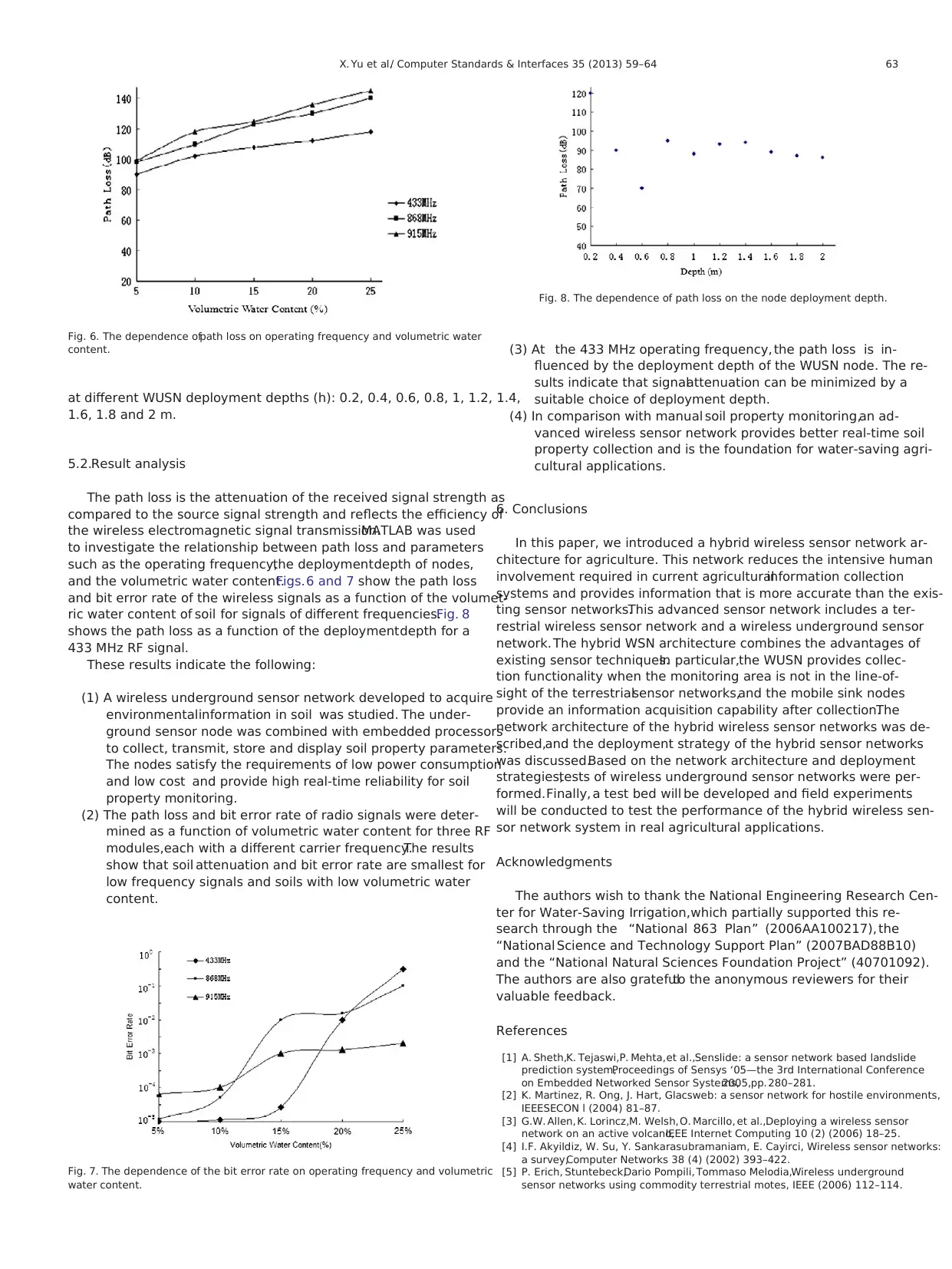
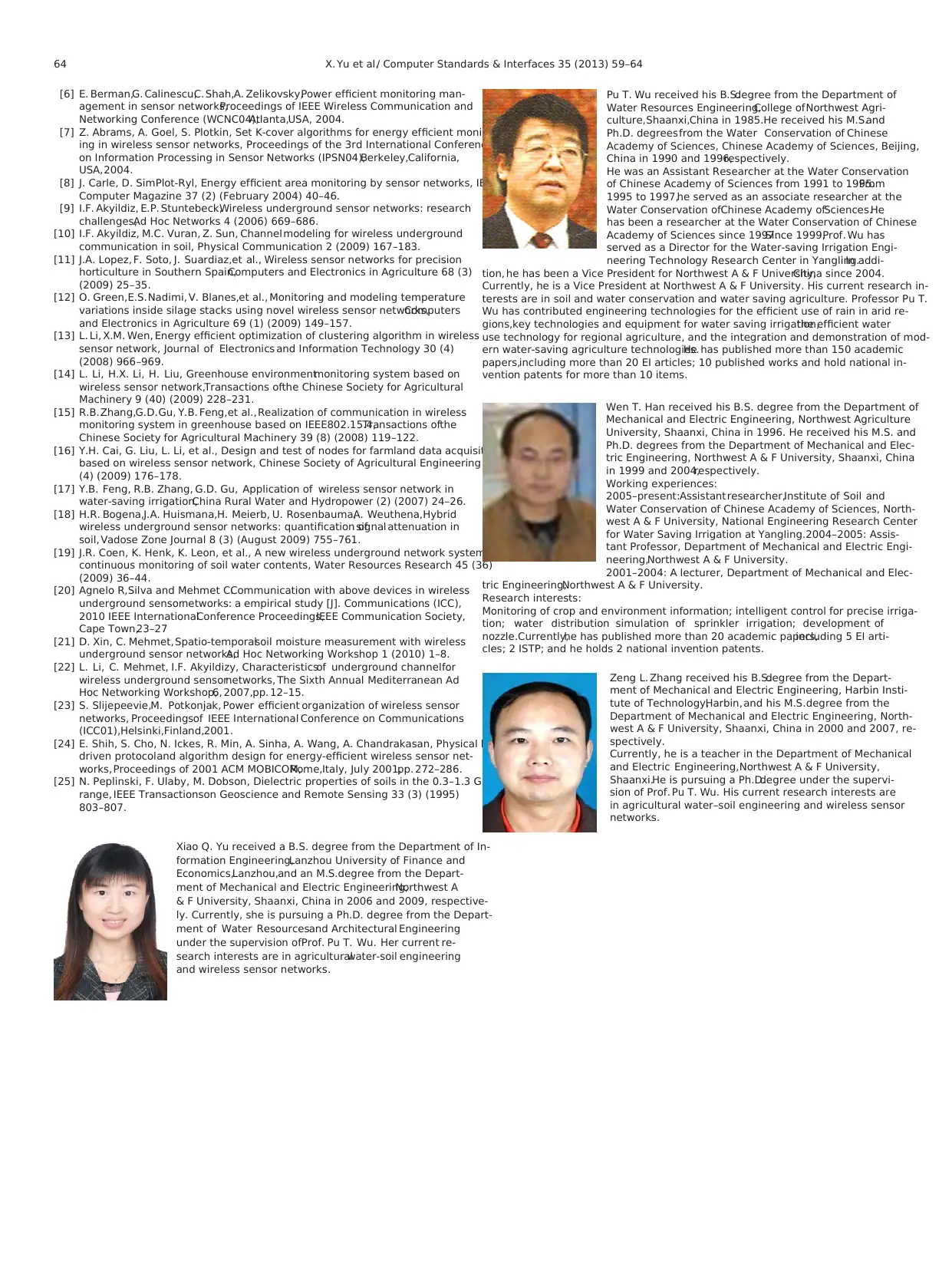
at different WUSN deployment depths (h): 0.2, 0.4, 0.6, 0.8, 1, 1.2, 1.4,
1.6, 1.8 and 2 m.
5.2.Result analysis
The path loss is the attenuation of the received signal strength as
compared to the source signal strength and reflects the efficiency of
the wireless electromagnetic signal transmission.MATLAB was used
to investigate the relationship between path loss and parameters
such as the operating frequency,the deploymentdepth of nodes,
and the volumetric water content.Figs.6 and 7 show the path loss
and bit error rate of the wireless signals as a function of the volumet-
ric water content of soil for signals of different frequencies.Fig. 8
shows the path loss as a function of the deploymentdepth for a
433 MHz RF signal.
These results indicate the following:
(1) A wireless underground sensor network developed to acquire
environmentalinformation in soil was studied. The under-
ground sensor node was combined with embedded processors
to collect, transmit, store and display soil property parameters.
The nodes satisfy the requirements of low power consumption
and low cost and provide high real-time reliability for soil
property monitoring.
(2) The path loss and bit error rate of radio signals were deter-
mined as a function of volumetric water content for three RF
modules,each with a different carrier frequency.The results
show that soil attenuation and bit error rate are smallest for
low frequency signals and soils with low volumetric water
content.
(3) At the 433 MHz operating frequency, the path loss is in-
fluenced by the deployment depth of the WUSN node. The re-
sults indicate that signalattenuation can be minimized by a
suitable choice of deployment depth.
(4) In comparison with manual soil property monitoring,an ad-
vanced wireless sensor network provides better real-time soil
property collection and is the foundation for water-saving agri-
cultural applications.
6. Conclusions
In this paper, we introduced a hybrid wireless sensor network ar-
chitecture for agriculture. This network reduces the intensive human
involvement required in current agriculturalinformation collection
systems and provides information that is more accurate than the exis-
ting sensor networks.This advanced sensor network includes a ter-
restrial wireless sensor network and a wireless underground sensor
network. The hybrid WSN architecture combines the advantages of
existing sensor techniques.In particular,the WUSN provides collec-
tion functionality when the monitoring area is not in the line-of-
sight of the terrestrialsensor networks,and the mobile sink nodes
provide an information acquisition capability after collection.The
network architecture of the hybrid wireless sensor networks was de-
scribed,and the deployment strategy of the hybrid sensor networks
was discussed.Based on the network architecture and deployment
strategies,tests of wireless underground sensor networks were per-
formed.Finally, a test bed will be developed and field experiments
will be conducted to test the performance of the hybrid wireless sen-
sor network system in real agricultural applications.
Acknowledgments
The authors wish to thank the National Engineering Research Cen-
ter for Water-Saving Irrigation,which partially supported this re-
search through the “National 863 Plan” (2006AA100217), the
“National Science and Technology Support Plan” (2007BAD88B10)
and the “National Natural Sciences Foundation Project” (40701092).
The authors are also gratefulto the anonymous reviewers for their
valuable feedback.
References
[1] A. Sheth,K. Tejaswi,P. Mehta,et al.,Senslide: a sensor network based landslide
prediction system,Proceedings of Sensys ‘05—the 3rd International Conference
on Embedded Networked Sensor Systems,2005,pp. 280–281.
[2] K. Martinez, R. Ong, J. Hart, Glacsweb: a sensor network for hostile environments,
IEEESECON l (2004) 81–87.
[3] G.W. Allen, K. Lorincz,M. Welsh, O. Marcillo, et al.,Deploying a wireless sensor
network on an active volcano,IEEE Internet Computing 10 (2) (2006) 18–25.
[4] I.F. Akyildiz, W. Su, Y. Sankarasubramaniam, E. Cayirci, Wireless sensor networks:
a survey,Computer Networks 38 (4) (2002) 393–422.
[5] P. Erich, Stuntebeck,Dario Pompili, Tommaso Melodia,Wireless underground
sensor networks using commodity terrestrial motes, IEEE (2006) 112–114.
Fig. 6. The dependence ofpath loss on operating frequency and volumetric water
content.
Fig. 7. The dependence of the bit error rate on operating frequency and volumetric
water content.
Fig. 8. The dependence of path loss on the node deployment depth.
63X. Yu et al./ Computer Standards & Interfaces 35 (2013) 59–64
[6] E. Berman,G. Calinescu,C. Shah,A. Zelikovsky,Power efficient monitoring man-
agement in sensor networks,Proceedings of IEEE Wireless Communication and
Networking Conference (WCNC04),Atlanta,USA, 2004.
[7] Z. Abrams, A. Goel, S. Plotkin, Set K-cover algorithms for energy efficient monitor-
ing in wireless sensor networks, Proceedings of the 3rd International Conference
on Information Processing in Sensor Networks (IPSN04),Berkeley,California,
USA,2004.
[8] J. Carle, D. SimPlot-Ryl, Energy efficient area monitoring by sensor networks, IEEE
Computer Magazine 37 (2) (February 2004) 40–46.
[9] I.F. Akyildiz, E.P. Stuntebeck,Wireless underground sensor networks: research
challenges,Ad Hoc Networks 4 (2006) 669–686.
[10] I.F. Akyildiz, M.C. Vuran, Z. Sun, Channelmodeling for wireless underground
communication in soil, Physical Communication 2 (2009) 167–183.
[11] J.A. Lopez, F. Soto, J. Suardiaz,et al., Wireless sensor networks for precision
horticulture in Southern Spain,Computers and Electronics in Agriculture 68 (3)
(2009) 25–35.
[12] O. Green,E.S.Nadimi, V. Blanes,et al., Monitoring and modeling temperature
variations inside silage stacks using novel wireless sensor networks,Computers
and Electronics in Agriculture 69 (1) (2009) 149–157.
[13] L. Li, X.M. Wen, Energy efficient optimization of clustering algorithm in wireless
sensor network, Journal of Electronics and Information Technology 30 (4)
(2008) 966–969.
[14] L. Li, H.X. Li, H. Liu, Greenhouse environmentmonitoring system based on
wireless sensor network,Transactions ofthe Chinese Society for Agricultural
Machinery 9 (40) (2009) 228–231.
[15] R.B.Zhang,G.D.Gu, Y.B. Feng,et al.,Realization of communication in wireless
monitoring system in greenhouse based on IEEE802.15.4,Transactions ofthe
Chinese Society for Agricultural Machinery 39 (8) (2008) 119–122.
[16] Y.H. Cai, G. Liu, L. Li, et al., Design and test of nodes for farmland data acquisition
based on wireless sensor network, Chinese Society of Agricultural Engineering 25
(4) (2009) 176–178.
[17] Y.B. Feng, R.B. Zhang, G.D. Gu, Application of wireless sensor network in
water-saving irrigation,China Rural Water and Hydropower (2) (2007) 24–26.
[18] H.R. Bogena,J.A. Huismana,H. Meierb, U. Rosenbauma,A. Weuthena,Hybrid
wireless underground sensor networks: quantification ofsignal attenuation in
soil, Vadose Zone Journal 8 (3) (August 2009) 755–761.
[19] J.R. Coen, K. Henk, K. Leon, et al., A new wireless underground network system for
continuous monitoring of soil water contents, Water Resources Research 45 (36)
(2009) 36–44.
[20] Agnelo R,Silva and Mehmet C.Communication with above devices in wireless
underground sensornetworks: a empirical study [J]. Communications (ICC),
2010 IEEE InternationalConference Proceedings,IEEE Communication Society,
Cape Town,23–27
[21] D. Xin, C. Mehmet,Spatio-temporalsoil moisture measurement with wireless
underground sensor networks,Ad Hoc Networking Workshop 1 (2010) 1–8.
[22] L. Li, C. Mehmet, I.F. Akyildizy, Characteristicsof underground channelfor
wireless underground sensornetworks, The Sixth Annual Mediterranean Ad
Hoc Networking Workshop,6, 2007,pp. 12–15.
[23] S. Slijepeevie,M. Potkonjak, Power efficient organization of wireless sensor
networks, Proceedingsof IEEE International Conference on Communications
(ICC01),Helsinki,Finland,2001.
[24] E. Shih, S. Cho, N. Ickes, R. Min, A. Sinha, A. Wang, A. Chandrakasan, Physical layer
driven protocoland algorithm design for energy-efficient wireless sensor net-
works, Proceedings of 2001 ACM MOBICOM,Rome,Italy, July 2001,pp. 272–286.
[25] N. Peplinski, F. Ulaby, M. Dobson, Dielectric properties of soils in the 0.3–1.3 GHz
range, IEEE Transactionson Geoscience and Remote Sensing 33 (3) (1995)
803–807.
Xiao Q. Yu received a B.S. degree from the Department of In-
formation Engineering,Lanzhou University of Finance and
Economics,Lanzhou,and an M.S.degree from the Depart-
ment of Mechanical and Electric Engineering,Northwest A
& F University, Shaanxi, China in 2006 and 2009, respective-
ly. Currently, she is pursuing a Ph.D. degree from the Depart-
ment of Water Resourcesand Architectural Engineering
under the supervision ofProf. Pu T. Wu. Her current re-
search interests are in agriculturalwater-soil engineering
and wireless sensor networks.
Pu T. Wu received his B.S.degree from the Department of
Water Resources Engineering,College ofNorthwest Agri-
culture,Shaanxi,China in 1985.He received his M.S.and
Ph.D. degreesfrom the Water Conservation of Chinese
Academy of Sciences, Chinese Academy of Sciences, Beijing,
China in 1990 and 1996,respectively.
He was an Assistant Researcher at the Water Conservation
of Chinese Academy of Sciences from 1991 to 1995.From
1995 to 1997,he served as an associate researcher at the
Water Conservation ofChinese Academy ofSciences.He
has been a researcher at the Water Conservation of Chinese
Academy of Sciences since 1997.Since 1999,Prof. Wu has
served as a Director for the Water-saving Irrigation Engi-
neering Technology Research Center in Yangling.In addi-
tion, he has been a Vice President for Northwest A & F University,China since 2004.
Currently, he is a Vice President at Northwest A & F University. His current research in-
terests are in soil and water conservation and water saving agriculture. Professor Pu T.
Wu has contributed engineering technologies for the efficient use of rain in arid re-
gions,key technologies and equipment for water saving irrigation,the efficient water
use technology for regional agriculture, and the integration and demonstration of mod-
ern water-saving agriculture technologies.He has published more than 150 academic
papers,including more than 20 EI articles; 10 published works and hold national in-
vention patents for more than 10 items.
Wen T. Han received his B.S. degree from the Department of
Mechanical and Electric Engineering, Northwest Agriculture
University, Shaanxi, China in 1996. He received his M.S. and
Ph.D. degrees from the Department of Mechanical and Elec-
tric Engineering, Northwest A & F University, Shaanxi, China
in 1999 and 2004,respectively.
Working experiences:
2005–present:Assistantresearcher,Institute of Soil and
Water Conservation of Chinese Academy of Sciences, North-
west A & F University, National Engineering Research Center
for Water Saving Irrigation at Yangling.2004–2005: Assis-
tant Professor, Department of Mechanical and Electric Engi-
neering,Northwest A & F University.
2001–2004: A lecturer, Department of Mechanical and Elec-
tric Engineering,Northwest A & F University.
Research interests:
Monitoring of crop and environment information; intelligent control for precise irriga-
tion; water distribution simulation of sprinkler irrigation; development of
nozzle.Currently,he has published more than 20 academic papers,including 5 EI arti-
cles; 2 ISTP; and he holds 2 national invention patents.
Zeng L. Zhang received his B.S.degree from the Depart-
ment of Mechanical and Electric Engineering, Harbin Insti-
tute of Technology,Harbin, and his M.S.degree from the
Department of Mechanical and Electric Engineering, North-
west A & F University, Shaanxi, China in 2000 and 2007, re-
spectively.
Currently, he is a teacher in the Department of Mechanical
and Electric Engineering,Northwest A & F University,
Shaanxi.He is pursuing a Ph.D.degree under the supervi-
sion of Prof. Pu T. Wu. His current research interests are
in agricultural water–soil engineering and wireless sensor
networks.
64 X. Yu et al./ Computer Standards & Interfaces 35 (2013) 59–64
⊘ This is a preview!⊘
Do you want full access?
Subscribe today to unlock all pages.
Trusted by 1+ million students worldwide
1 out of 6


Your All-in-One AI-Powered Toolkit for Academic Success.
+13062052269
info@desklib.com
Available 24*7 on WhatsApp / Email
![[object Object]](/_next/static/media/star-bottom.7253800d.svg)
Unlock your academic potential
Copyright © 2020–2026 A2Z Services. All Rights Reserved. Developed and managed by ZUCOL.