Literature Survey on GPS for ELE4ACS/5PMC: 2019 Project Overview
VerifiedAdded on 2022/11/10
|8
|1768
|172
Report
AI Summary
This report presents a comprehensive literature survey on the Global Positioning System (GPS), a crucial technology for accurate location measurement. The survey delves into various aspects, starting with the satellite radio navigation system and its vulnerabilities. It explores the infrastructure of satellite systems, highlighting the roles of base stations and mobility management. The report examines GPS antennas, including patch antennas and hemi spiral designs. It also covers GPS frequencies, modulation techniques, and link budget calculations. Furthermore, the survey discusses the integration of artificial intelligence to improve the accuracy of the GPS system for land vehicle navigation. The report concludes with a summary of the key findings and references relevant literature, providing a solid foundation for understanding the GPS technology and its applications.

Running head: ELE4ACS/5PMC
ELE4ACS/5PMC
Name of the Student
Name of the University
Author Note
ELE4ACS/5PMC
Name of the Student
Name of the University
Author Note
Paraphrase This Document
Need a fresh take? Get an instant paraphrase of this document with our AI Paraphraser
1ELE4ACS/5PMC
Introduction:
The Global Positioning System or the GPS system which is originally known as the
NAVSTAR GPS, is actually a radionavigation system which works based on the satellites [7].
Currently this system is owned by the U.S. Government while it is operated by the Air Force of
the U.S. This is actually a global navigation satellite system which is used for fetching time
information and geo-location directly to a GPS receiver at any place in the earth [8]. In this
document a literature survey will be done on this GPS. Important knowledge will be delivered
through this literature survey.
Literature Review:
According to the authors Dempster and Cetin (2016), global navigation satellite systems
(GNSS) or the global positioning system (GPS) is currently ubiquitous in the perspective of
critical safety infrastructure. Currently, in the satellite radio navigation system one of the
growing concern is the vulnerability in the GNSS to the radio frequency interface (RFI). As per
the authors this type of vulnerability occurs within the system due to some unintentional or
intentional sources. Due to this fact the GNSS has become a critical type of infrastructure that
must be protected properly. In most of the cases the sources of these RFI are unknown for which
a passive localization system is required [1]. For this reason difficulty occurs in this system when
it is compared with the transmitter location system. Thus, a proper solution is required for this
case, which is leading to sensor network techniques which is consisting spatially distributed
sensor nodes. In this paper the author has successfully provided an overview of the current
existing system and has compared different techniques of interface geo-localization.
2ELE4ACS/5PMC
As per the authors Murray et al. (2019), regional networks of the GNSS cover
volcanically and seismically active areas in the whole United States. Data gathered from this
networks is mainly utilized for producing three component, high precision velocity field which is
capable of covering a wide geographic region. In this aspect the authors has also discussed the
infrastructure of satellite system. As per the authors there are several of groups, which works
together so that a satellite infrastructure can be functional [2]. This infrastructure of the satellite
system establishes the communication by utilizing a LOS beam, where the satellites can be
controlled by the base stations. In the overall infrastructure of the system base stations for the
communication is considered as the heart of the overall system. In this infrastructure for the
mobility management of the satellite the pair of HLR-VLR is utilized in this case. In this
infrastructure for noting the location of the satellites a satellite user mapping register is utilized.
As per the authors these are the main infrastructure of the satellite systems. The author has also
identified that the real time GNSS also aid in the aspects of ionosphere disturbances.
As per the authors Dubé, Bernard and Gertsvolf (2017), the link budget calculation can
be considered as accounting of all types of losses and gains from a transmitter, through a
medium which includes cable, free space, fibre, web guide etc. These gain and losses goes
directly to a receiver within a telecommunication system. Here, the authors has reported results
of a recent measurement of the absolute frequency of the 5 s2 S1
2
−4 d2 D5
2 transition of the 88SR+
ion [3]. The authors has also provided a proper type of GPS link budget calculation method in
this article. Using this method the link budget calculation is done for GPS satellite to GPS
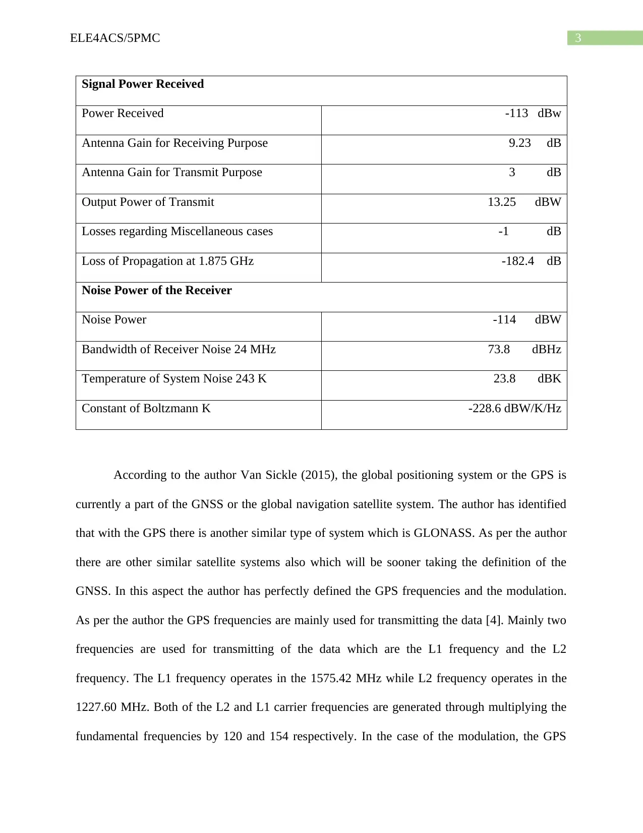
receiver. In the following table this link budget is demonstrated.
⊘ This is a preview!⊘
Do you want full access?
Subscribe today to unlock all pages.

Trusted by 1+ million students worldwide
3ELE4ACS/5PMC
Signal Power Received
Power Received ‐113 dBw
Antenna Gain for Receiving Purpose 9.23 dB
Antenna Gain for Transmit Purpose 3 dB
Output Power of Transmit 13.25 dBW
Losses regarding Miscellaneous cases ‐1 dB
Loss of Propagation at 1.875 GHz ‐182.4 dB
Noise Power of the Receiver
Noise Power ‐114 dBW
Bandwidth of Receiver Noise 24 MHz 73.8 dBHz
Temperature of System Noise 243 K 23.8 dBK
Constant of Boltzmann K ‐228.6 dBW/K/Hz
According to the author Van Sickle (2015), the global positioning system or the GPS is
currently a part of the GNSS or the global navigation satellite system. The author has identified
that with the GPS there is another similar type of system which is GLONASS. As per the author
there are other similar satellite systems also which will be sooner taking the definition of the
GNSS. In this aspect the author has perfectly defined the GPS frequencies and the modulation.
As per the author the GPS frequencies are mainly used for transmitting the data [4]. Mainly two
frequencies are used for transmitting of the data which are the L1 frequency and the L2
frequency. The L1 frequency operates in the 1575.42 MHz while L2 frequency operates in the
1227.60 MHz. Both of the L2 and L1 carrier frequencies are generated through multiplying the
fundamental frequencies by 120 and 154 respectively. In the case of the modulation, the GPS
Paraphrase This Document
Need a fresh take? Get an instant paraphrase of this document with our AI Paraphraser
4ELE4ACS/5PMC
carriers uses the phase modulation transferring the information. In this case it has been assessed
that in the aspect the carrier can be modulated in several of ways. Also, in the case of GPS the
carriers can be modulated in several of ways for carrying the binary codes. Both of the frequency
and amplitude modulation is omitted in this case. Only thee phase modulation is utilized in this
case as it allow to carry the binary codes from the satellites to the carriers.
According to the authors Kataria, Gao and Bernhard (2019), hemi spiral antenna design is
one of the useful antenna designs which can be used for the GPS systems. As per the authors this
design of the GPS antenna is one of the important antenna designs as the distinct radiation
pattern of it, provides the capability to the receivers to determine the angular directions of the
signals which are incoming [5]. The whole process is done in the noise without utilization of any
type of array. In this aspect the authors have defined that most common type of GPS antenna is
the patch antenna. The patch antenna is flat in nature. This type of GPS antenna is having a metal
and a ceramic body and the whole body is mounted metal base plate.
The authors Li et al. (2017), has defined that the accuracy of the GPS system for the land
vehicle navigation can be improved further by integrating artificial intelligence within it. To
perform this the GPS system, need to be integrated with the Strapdown Inertial Navigation
System or the SINS. Thus, the author has proposed ensemble learning algorithm rather than the
traditional type of neural network. Authors has used this for the scenario so that all the
limitations regarding dynamic and complex data ceased by the irregular movement of the vehicle
can be resolved [6]. The authors have verified the performance of their proposed algorithm by
using the SINS and GPS data of the different trajectories which have been collected from the
same type of land vehicle navigation tests.
5ELE4ACS/5PMC
Conclusion:
From the above discussion it can be concluded that GPS or the global positioning system
is one of the most advanced technology for accurately measuring the location of a user. For the
functionality of this system properly it is currently dependant on various of satellites system of it.
In this report a vast literature survey regarding the GPS system has been done. In this literature
survey various aspects of the GPS system have been discussed. In this literature survey first the
satellite radio navigation has been discussed. The other important GPS factors which has been
discussed in this literature survey are the satellite system infrastructure, GPS antennas, GPS-link
budget calculation and GPS frequencies and modulation.
⊘ This is a preview!⊘
Do you want full access?
Subscribe today to unlock all pages.

Trusted by 1+ million students worldwide
6ELE4ACS/5PMC
References:
[1] A. Dempster and E. Cetin, "Interference Localization for Satellite Navigation
Systems", Proceedings of the IEEE, vol. 104, no. 6, pp. 1318-1326, 2016. Available:
10.1109/jproc.2016.2530814.
[2] J. Murray et al., "Regional Global Navigation Satellite System Networks for Crustal
Deformation Monitoring", Seismological Research Letters, 2019. Available:
10.1785/0220190113.
[3] P. Dubé, J. Bernard and M. Gertsvolf, "Absolute frequency measurement of the88Sr+clock
transition using a GPS link to the SI second", Metrologia, vol. 54, no. 3, pp. 290-298, 2017.
Available: 10.1088/1681-7575/aa5e60.
[4] J. Van Sickle, GPS for land surveyors.
[5] C. Kataria, G. Gao and J. Bernhard, "Design of a Compact Hemispiral GPS Antenna With
Direction Finding Capabilities", IEEE Transactions on Antennas and Propagation, vol. 67, no.
5, pp. 2878-2885, 2019. Available: 10.1109/tap.2019.2899009.
[6] J. Li, N. Song, G. Yang, M. Li and Q. Cai, "Improving positioning accuracy of vehicular
navigation system during GPS outages utilizing ensemble learning algorithm", Information
Fusion, vol. 35, pp. 1-10, 2017. Available: 10.1016/j.inffus.2016.08.001.
[7] D. Brown, D. Dwyer, S. Robertson and P. Gastin, "Metabolic Power Method:
Underestimation of Energy Expenditure in Field-Sport Movements Using a Global Positioning
System Tracking System", International Journal of Sports Physiology and Performance, vol. 11,
no. 8, pp. 1067-1073, 2016. Available: 10.1123/ijspp.2016-0021.
Paraphrase This Document
Need a fresh take? Get an instant paraphrase of this document with our AI Paraphraser

7ELE4ACS/5PMC
[8] K. Larson, "Unanticipated Uses of the Global Positioning System", Annual Review of Earth
and Planetary Sciences, vol. 47, no. 1, pp. 19-40, 2019. Available: 10.1146/annurev-earth-
053018-060203 [Accessed 13 September 2019].
[8] K. Larson, "Unanticipated Uses of the Global Positioning System", Annual Review of Earth
and Planetary Sciences, vol. 47, no. 1, pp. 19-40, 2019. Available: 10.1146/annurev-earth-
053018-060203 [Accessed 13 September 2019].
1 out of 8
Related Documents
Your All-in-One AI-Powered Toolkit for Academic Success.
+13062052269
info@desklib.com
Available 24*7 on WhatsApp / Email
![[object Object]](/_next/static/media/star-bottom.7253800d.svg)
Unlock your academic potential
Copyright © 2020–2025 A2Z Services. All Rights Reserved. Developed and managed by ZUCOL.


