Foundation Engineering Report: Karst and Tunneling Challenges
VerifiedAdded on 2022/12/27
|14
|3321
|33
Report
AI Summary
This report delves into the geotechnical challenges encountered in foundation engineering, specifically focusing on the impact of karst formations on tunneling projects. It explores the hazards associated with groundwater, including void crossings and caverns, and discusses various hydrogeological models used to assess and mitigate these risks. The report highlights the importance of thorough hydrogeological studies and presents case studies from Poland and Greece, demonstrating how these challenges are addressed in real-world scenarios. It examines the impact of groundwater table lowering, the use of drainage systems, and the importance of considering the local geology and hydrogeological parameters. The report also covers the potential effects on surrounding areas, such as lakes and the need for sealing and groundwater control. Overall, the report provides a comprehensive overview of the complexities involved in foundation engineering in karst environments and the strategies used to ensure the safety and stability of tunneling projects.
FOUNDATION ENGINEERING
By Name
Course
Instructor
Institution
Location
Date
By Name
Course
Instructor
Institution
Location
Date
Paraphrase This Document
Need a fresh take? Get an instant paraphrase of this document with our AI Paraphraser
ABSTRACT
Despite the fact, carbon rock and
limestone exhibit good geotechnical
behavior especially in the karstic process but
in most cases, they induce hazard during the
operation of tunneling which may lead to
many problems[1]. The groundwater is the
main cause of the crossing of voids as well
as cavern which are both filled and empty.
During the estimation of encountering
probability of such conditions as well as
preparing to face them there is need of a
thorough hydrogeological study. This is
done so as to assist in the complementing
the ancient program of investigation. The
research work has therefore concentrated on
the basin karstic aquifer with hydrological
characteristics [2].
The lieterature piece that has been
provided has comprehensively discussed
various models of hydrogeological which
have entirely reluied on the geometry of the
aquifer of any tunnel of Karstic.This has
considered its position in relation to the zone
of inundation. At least every model has
specific tunneling as per the
countermeasures as well as hazards [3].
Such big limestone crossing is discussed
through the history of the case studies
because it is very likely that some mountains
interior are not affected by the karstification
as well as the order of presenting the
deviation number from the persisting regime
hydrogeological.
Keywords: Karst, Hydrological,
groundwater
INTRODUCTION
Groundwater is always the main source
of problem during the construction of the
tunnel when checking on the safety and
stability issues. One of the biggest
challenges to the designers and contractors
is how to control groundwater during
construction and operation of the tunnels.
Facilities such as drainage may be needed
from the heading and if necessary inverted

recommended sizes are absent ending up
adding trouble to the expense of pumping
which appeared to be unavoidable. In most
cases the liquid also affects the roof and
faces of stability.When this happens in the
quantity appreciable then it can possibly
block processes of construction. In the event
that the ground treated as the host is very
soft then there may be an obvious increased
risk of erosion [7].
Both leakages and seepages in the
underground works from surrounding
aquifer also cause a great effect to the
ground as well as the adjacent facilities. This
depends on the local geology,
hydrogeological, and the parameter of the
geotechnical materials, though a serious
environmental impact must be expected. The
opposite case is the leakage in the
underground channel leading to possible
aquifer works. This implies that the hazard
of groundwater contamination must be put
into consideration. Mining always happens
due to the underground void space extension
involved as well as the lining absence. This
process, therefore, can seriously affect the
surrounding conditions of hydrogeological
set up leading to an increased risk for both
instability development and for groundwater
resources depletion [5].
The void crossing and caverns, whether
aquiferous, empty or filled with erodible
material causes problems whose solution
should be engineered and are often treated
as site-specific. In most cases, carbonate and
limestone rocks generally show a good
geotechnical behavior if karstic but they also
induce the aforementioned problems during
the tunneling operations. Therefore, most
engineering involving projects are now
being constructed in countries where
limestone is the most common geological
formation. The underground excavation
design in these materials needs geological
knowledge and hydrogeological model
where the excavation is being carried out[6].
⊘ This is a preview!⊘
Do you want full access?
Subscribe today to unlock all pages.

Trusted by 1+ million students worldwide
The case of confronting karstic
groundwater within mines
It is not advisable to use grouting
during the mine galleries extractions or even
during opencast exploitation. Therefore, a
more elaborate strategy is applied here to
dewater the entire mining zone, hence
maintaining a huge depression core around
when the mine is worked up.
Poland Mine Case Studies
The most prudent example of the
method is comprehensively illustrated by the
lead/ zinc development in Poland that is
located at Olkusz. These ores are in filling
cavities and dolines within a dolomite
paleokarst at the depth of 200to 300m below
Quaternary sediments plain within the
hydrologic contact with bedrock[9].
Although this is sometimes perceived to be a
very hazardous situation as far as the mining
process is concerned it is a crucial stage. A
survey was done on an area of 500km2 about
the potential mine(Kaprara et al.2015). The
contained were 70 natural springs and 600
wells. After that exploitation borehole
amounting to 1700 were drilled. The
installation of piezometer was done in 300
wells as well as carrying a pumping test in
the boreholes. The estimation in the latter
showed that 300 × 106 m3 of the
groundwater should be pump to enhance the
establishment of depression cone for the
mine[8]. The cone was pumped through
vertical wells and drainage audits having a
higher capacity pump cut beneath the level
of extraction before the extraction started.
Therefore, meaning that the highest local
inrushes of water were contained to 1.5m3/ s
in the capacity of the pump.
The Greece case: groundwater table
lowering prediction for lignite mining and
its implications on the environment.
The extensive lignite deposits found
in the Ptolemais basin within the Macedonia
area of North Greece are exploited for
Paraphrase This Document
Need a fresh take? Get an instant paraphrase of this document with our AI Paraphraser
generation of the electric thermal plant. A
lignite-bearing horizon covers an area of
about 50-70 meters in thickness and 100-200
mOD sterile overburden.
Avery large scale of open-cast techniques of
mining is used in the removal and disposal
of overburden and coal excavation. The
operations of earth-removing are couple
with extensive groundwater lowering table
within the basin alluvia by the use of deep
well alone mines periphery.
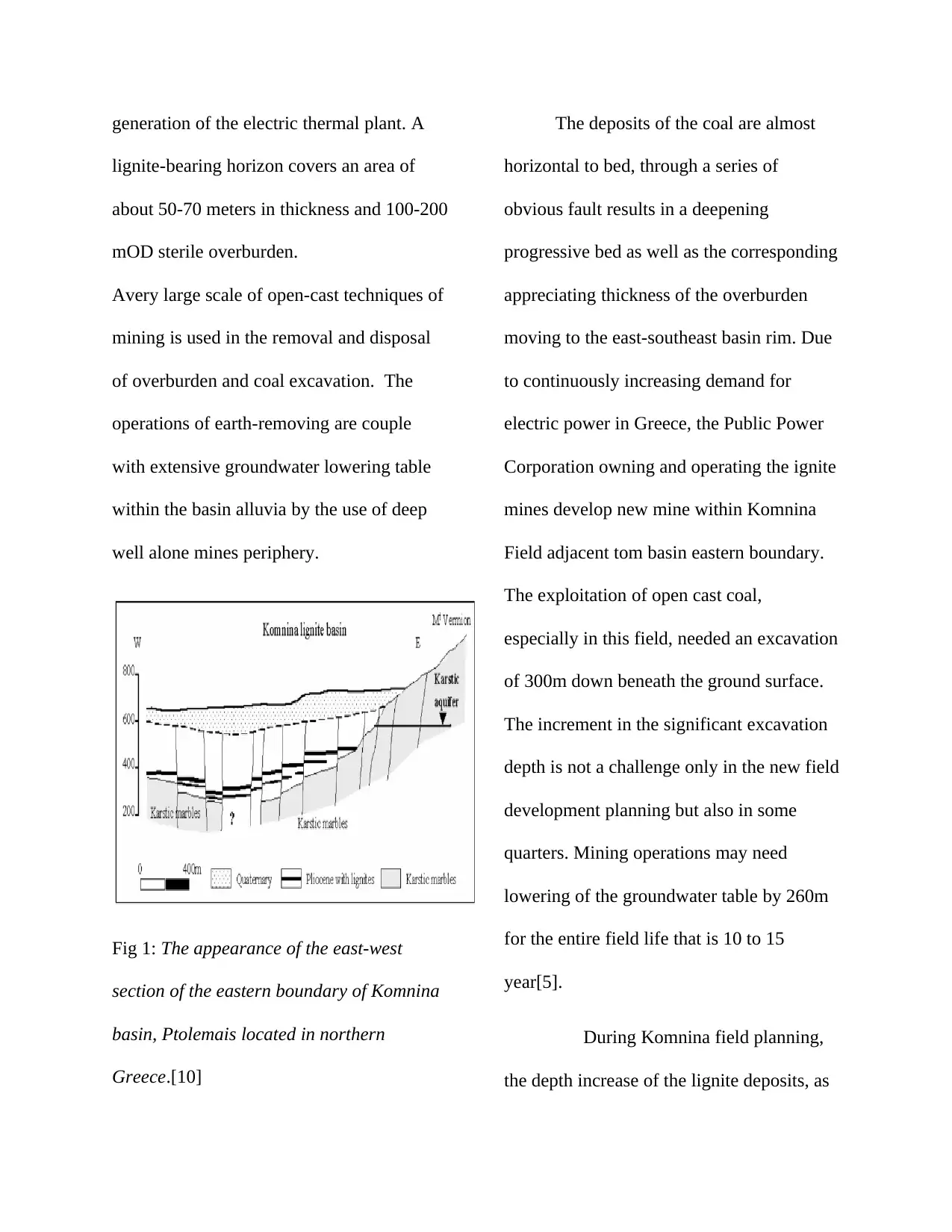
Fig 1: The appearance of the east-west
section of the eastern boundary of Komnina
basin, Ptolemais located in northern
Greece.[10]
The deposits of the coal are almost
horizontal to bed, through a series of
obvious fault results in a deepening
progressive bed as well as the corresponding
appreciating thickness of the overburden
moving to the east-southeast basin rim. Due
to continuously increasing demand for
electric power in Greece, the Public Power
Corporation owning and operating the ignite
mines develop new mine within Komnina
Field adjacent tom basin eastern boundary.
The exploitation of open cast coal,
especially in this field, needed an excavation
of 300m down beneath the ground surface.
The increment in the significant excavation
depth is not a challenge only in the new field
development planning but also in some
quarters. Mining operations may need
lowering of the groundwater table by 260m
for the entire field life that is 10 to 15
year[5].
During Komnina field planning,
the depth increase of the lignite deposits, as
well as the field proximity toward the
eastern boundary of the Ptolemais basin,
consisted of highly karstified marbles water-
bearing, therefore, making groundwater
table lowering extremely costly. However,
the effect of an extensive operation like that
case extended to a very significant distance
from the mine, thus altering a region
hydrological budget that has been stressed
already by over-exploitation of the intensive
use of in the industry and irrigated
agriculture. More specifically, long-term
groundwater table lowering can also affect
hydrological Lake Vegoritis budget a
distance of 9km to the north of the
Komnina Field in consideration to
the possible to its ecosystem. Therefore, it
was necessary for studying the karst aquifer
nature along the eastern Ptolemais basin
boundary as well as assess the dewatering
feasibility and how it affects hydrological
region budget.
A hydrogeological investigation
done in well-developed karstic marble of
western Mount Vermion showed that the
existence of the single quite homogenous
aquifer with a hydraulic of a low gradient
(0.02-0.05) toward the southeast and a
higher transmissivity (0.01-0.1m2) as in
figure 2 below. The aquifer high
transmissivity poses a severe problem to the
feasibility of the needed extensive and
groundwater table lowering that have been
sustained.
⊘ This is a preview!⊘
Do you want full access?
Subscribe today to unlock all pages.

Trusted by 1+ million students worldwide
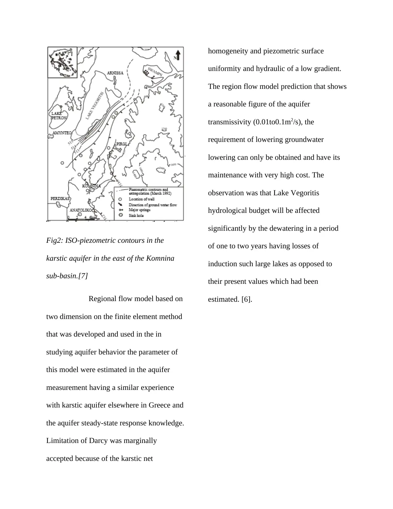
Fig2: ISO-piezometric contours in the
karstic aquifer in the east of the Komnina
sub-basin.[7]
Regional flow model based on
two dimension on the finite element method
that was developed and used in the in
studying aquifer behavior the parameter of
this model were estimated in the aquifer
measurement having a similar experience
with karstic aquifer elsewhere in Greece and
the aquifer steady-state response knowledge.
Limitation of Darcy was marginally
accepted because of the karstic net
homogeneity and piezometric surface
uniformity and hydraulic of a low gradient.
The region flow model prediction that shows
a reasonable figure of the aquifer
transmissivity (0.01to0.1m2/s), the
requirement of lowering groundwater
lowering can only be obtained and have its
maintenance with very high cost. The
observation was that Lake Vegoritis
hydrological budget will be affected
significantly by the dewatering in a period
of one to two years having losses of
induction such large lakes as opposed to
their present values which had been
estimated. [6].
Paraphrase This Document
Need a fresh take? Get an instant paraphrase of this document with our AI Paraphraser
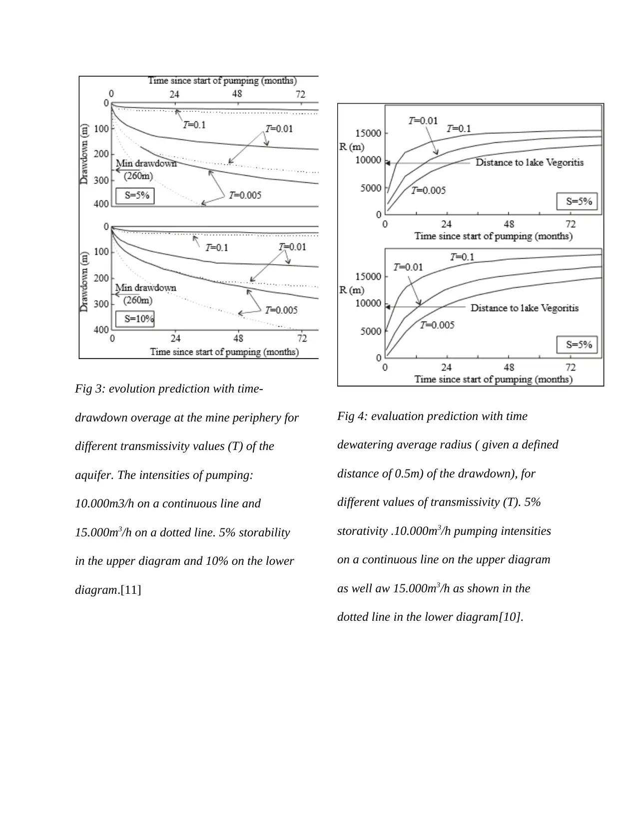
Fig 3: evolution prediction with time-
drawdown overage at the mine periphery for
different transmissivity values (T) of the
aquifer. The intensities of pumping:
10.000m3/h on a continuous line and
15.000m3/h on a dotted line. 5% storability
in the upper diagram and 10% on the lower
diagram.[11]
Fig 4: evaluation prediction with time
dewatering average radius ( given a defined
distance of 0.5m) of the drawdown), for
different values of transmissivity (T). 5%
storativity .10.000m3/h pumping intensities
on a continuous line on the upper diagram
as well aw 15.000m3/h as shown in the
dotted line in the lower diagram[10].
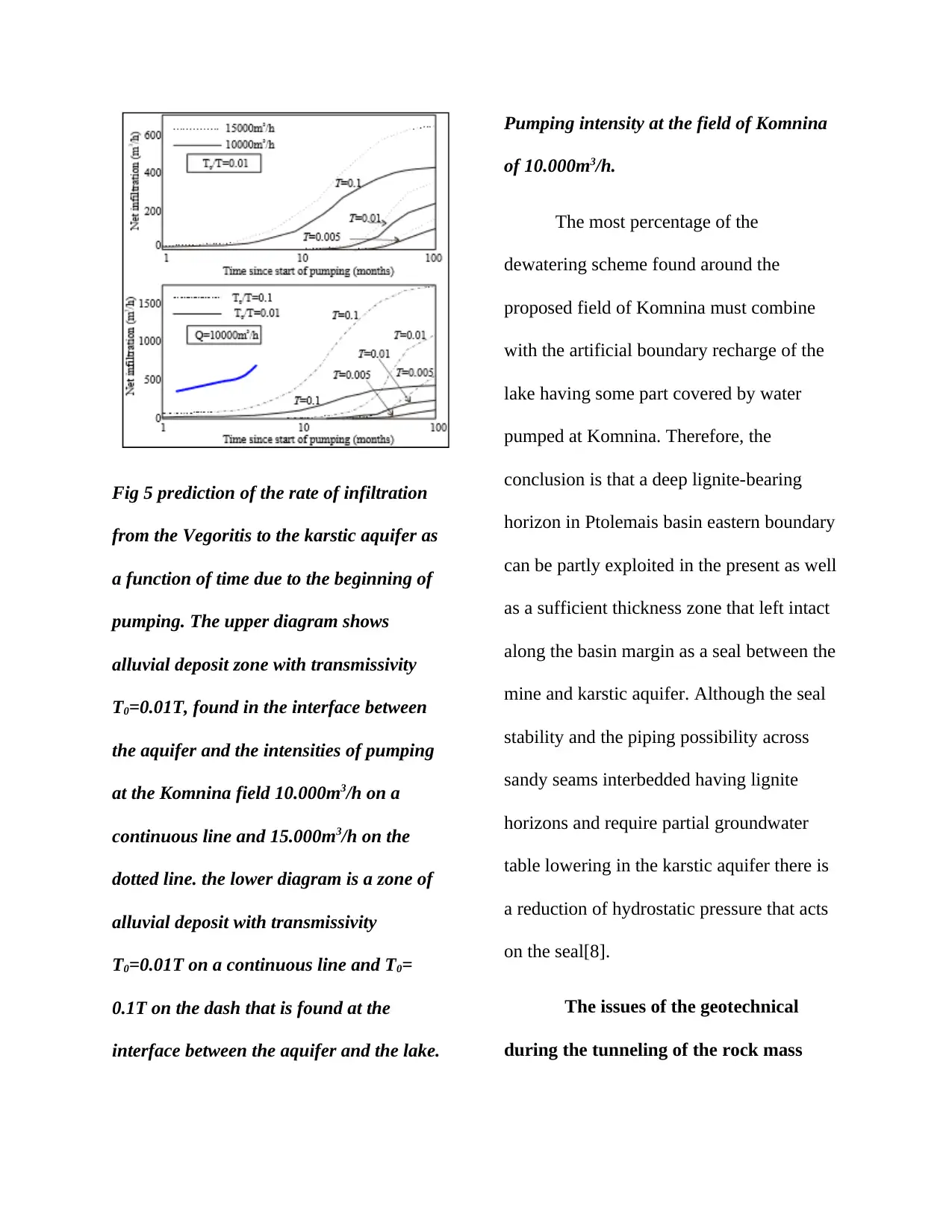
Fig 5 prediction of the rate of infiltration
from the Vegoritis to the karstic aquifer as
a function of time due to the beginning of
pumping. The upper diagram shows
alluvial deposit zone with transmissivity
T0=0.01T, found in the interface between
the aquifer and the intensities of pumping
at the Komnina field 10.000m3/h on a
continuous line and 15.000m3/h on the
dotted line. the lower diagram is a zone of
alluvial deposit with transmissivity
T0=0.01T on a continuous line and T0=
0.1T on the dash that is found at the
interface between the aquifer and the lake.
Pumping intensity at the field of Komnina
of 10.000m3/h.
The most percentage of the
dewatering scheme found around the
proposed field of Komnina must combine
with the artificial boundary recharge of the
lake having some part covered by water
pumped at Komnina. Therefore, the
conclusion is that a deep lignite-bearing
horizon in Ptolemais basin eastern boundary
can be partly exploited in the present as well
as a sufficient thickness zone that left intact
along the basin margin as a seal between the
mine and karstic aquifer. Although the seal
stability and the piping possibility across
sandy seams interbedded having lignite
horizons and require partial groundwater
table lowering in the karstic aquifer there is
a reduction of hydrostatic pressure that acts
on the seal[8].
The issues of the geotechnical
during the tunneling of the rock mass
⊘ This is a preview!⊘
Do you want full access?
Subscribe today to unlock all pages.

Trusted by 1+ million students worldwide
With the exception of the problem
associated with the characteristics of the
karstic, limestone as well as other rocks of
carbonate in general, show good
geotechnical behavior and ab friendly
tunneling response. They exhibit a good and
reasonable resistance in drilling or boring
with the decreased excavation tool wear.
The limestone rock mass strength does not
always reach a low level like those of a
squeezing ground, even if brecciated.
Breccias of the limestone in many cases
exhibit the good value of friction, though it
sometimes gives support to necessary with
steel sets or lattice girder, beyond both
shotcrete and rock bolt. From a different
point of view may conclude that, when a
great depth under high horizontal stresses
cannot give atypical bursting instability as in
the hard rock cases since it is not a brittle
material. Therefore, every mild spalling
problem within the tunnels can only be
satisfactorily only if coped with rock bolting
and if shotcrete is reinforced.
The case of karstic caverns and
voids
Reaching big karstic conduits and caverns
may be accompanied by these problems that
may be so difficult to overcome.
Bridging an empty void
Tunneling via a geotechnical filled
with weak materials.
Confronting inrush water associated
with mudflow when the targeted
holes contain water as well as having
material of the earth either partly or
fully.
In the urban tunnel cases having a thin
cover, then the voids occurrence can be
effectively studied by the use of program of
drilling with the testing assistance of testing
geotechnical means. In depths considered to
be shallow, geo-radar mostly gives reliable
information. S deeper tomography level is
Paraphrase This Document
Need a fresh take? Get an instant paraphrase of this document with our AI Paraphraser
the best choice since the tunnel that is close
to the surface is accompanied with the
collapsing risk of an adjacent cavern after
the earthquake, therefore filling the voids
prior to the tunnel completion is the
additional task to be undertaken.
In a deep tunnel case via the mountain and
having a clear indication of the cavities
presented, then the only reliable method is
probing ahead. For example, the Dodoni
tunnel in the north of Greece having a length
of 3.3 km and diameter of 12m is being
driven out currently in the sequence of
limestone with properly grown bedding
alongside other cases of the siltstone within
the intercalation of few centimeters locally.
It is important to note that encountered
limestone showed superb behavior that is
expected to continue. Though, significant
over breaks had happened in some of the
locations because of the karstic cavities
instability. The solution features of the
karstic generally, may be observed in
outcrop on the mountain ridges surface
crossed by the tunnel beneath cover no less
than 100m. Therefore the features show an
indication of karstic processes in the
limestone is active.
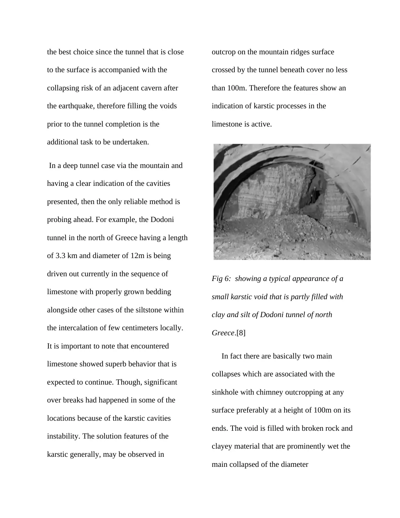
Fig 6: showing a typical appearance of a
small karstic void that is partly filled with
clay and silt of Dodoni tunnel of north
Greece.[8]
In fact there are basically two main
collapses which are associated with the
sinkhole with chimney outcropping at any
surface preferably at a height of 100m on its
ends. The void is filled with broken rock and
clayey material that are prominently wet the
main collapsed of the diameter
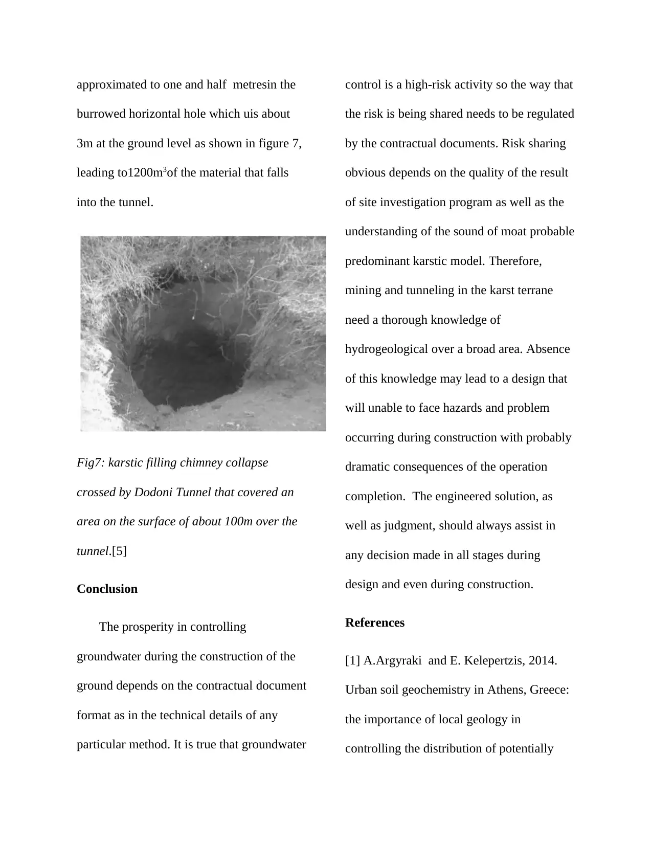
approximated to one and half metresin the
burrowed horizontal hole which uis about
3m at the ground level as shown in figure 7,
leading to1200m3of the material that falls
into the tunnel.
Fig7: karstic filling chimney collapse
crossed by Dodoni Tunnel that covered an
area on the surface of about 100m over the
tunnel.[5]
Conclusion
The prosperity in controlling
groundwater during the construction of the
ground depends on the contractual document
format as in the technical details of any
particular method. It is true that groundwater
control is a high-risk activity so the way that
the risk is being shared needs to be regulated
by the contractual documents. Risk sharing
obvious depends on the quality of the result
of site investigation program as well as the
understanding of the sound of moat probable
predominant karstic model. Therefore,
mining and tunneling in the karst terrane
need a thorough knowledge of
hydrogeological over a broad area. Absence
of this knowledge may lead to a design that
will unable to face hazards and problem
occurring during construction with probably
dramatic consequences of the operation
completion. The engineered solution, as
well as judgment, should always assist in
any decision made in all stages during
design and even during construction.
References
[1] A.Argyraki and E. Kelepertzis, 2014.
Urban soil geochemistry in Athens, Greece:
the importance of local geology in
controlling the distribution of potentially
⊘ This is a preview!⊘
Do you want full access?
Subscribe today to unlock all pages.

Trusted by 1+ million students worldwide
1 out of 14
Your All-in-One AI-Powered Toolkit for Academic Success.
+13062052269
info@desklib.com
Available 24*7 on WhatsApp / Email
![[object Object]](/_next/static/media/star-bottom.7253800d.svg)
Unlock your academic potential
Copyright © 2020–2025 A2Z Services. All Rights Reserved. Developed and managed by ZUCOL.