Impact of Urbanization on Water Infiltration
VerifiedAdded on 2023/04/19
|13
|1963
|361
AI Summary
This article discusses the negative impact of urbanization on the process of water infiltration into the ground. It explains how the construction of buildings and roads reduces surface areas for infiltration, leading to increased surface runoff. The article also highlights the destruction of forests and the role of trees in assisting water percolation. It concludes by emphasizing the reduction of underground water due to urbanization.
Contribute Materials
Your contribution can guide someone’s learning journey. Share your
documents today.
GEOGRAPHY
By Name
Course
Instructor
Institution
Location
Date
By Name
Course
Instructor
Institution
Location
Date
Secure Best Marks with AI Grader
Need help grading? Try our AI Grader for instant feedback on your assignments.
Question 12
During the hot season, the high temperatures result into the melting of glazier that ends up
draining their water into the rivers and streams this responsible for part of the water in the rivers,
streams, and lakes other than the lake water.
Question 13
How Urbanization affects the infiltration
Infiltration refers to the percolation of the rainwater preferable the surface runoff into the ground
during the rainy season. The percolation of surface water will always be dependent on the nature
of the surface. Urbanization has impacted the process of infiltration of water into the ground
negatively(Neves et al.2015). Construction of buildings and roads has reduced the surface areas
for infiltration. Most of the stormwater will remain as a surface runoff over the tarmac roads and
pavements instead of infiltrating into the ground. This has greatly reduced the volume of
underground water. Also, most of the rainwater stapped from the roofs by the use of gutter
leaving very little to reach the ground.
In some cases, the percolation of water is being assisted by the presence of trees. As a result of
the urbanization process, much of the forests have been destroyed to create room for the
development of buildings. This has further led to the reduction of underground water.
Part 2
Transportation. Deposition and Erosion
Question 14
Gravel, sand, silt, and clay. The gravel has the biggest sizes among the shortlisted particles. Clay
is some time teed to as mud because it has the smallest particles.
Question 15
Settling Velocity refers to the velocity sediments will begin to be deposited.
Question 16
Description between different velocities and when different sizes of particles are deposited
Large sized particles are deposited at a greater speed than the small-sized particles. In general,
the settling velocity increases with increase in the size of the particles. That is why from figure 2,
the particles of boulders settled at higher settling velocity of about 1000cm/sec as opposed to
clay whose settling velocity are much lower about 1cm/sec.
Question 17
What particles sizes are easier to erode?
The lightest particle will be easier to erode since low velocity will be required to pick up the
particles. Therefore it is clay. It is important to note that this consideration only works for the
case of the clay that is already suspended since when clay is attached to the surface it cannot be
easily eroded.
Question 18
It is easier for the particles of clay to be easily eroded because it requires less energy to be picked
up. It has less weight per unit volume.
Question 19
The relationship between the velocities required for the pick-up and the grain size
Larger than the sand: These particles have a large weight per unit volume. This implies that they
will need high velocities to be picked
Sand Sized: The sand-sized particles will need average velocity or the velocity that normal and is
being picked with.
Smaller than the sand: These particles have a smaller weight per unit volume hence they require
very little velocity to be picked up.
Question 20
Generally, clay is very sticky. In order for it to be detached from a surface, a considerable
amount of force will be required. This makes the required velocity that is slightly high. It is only
through this higher velocity that the required force can be generated.
Question 21
It is important to note that other than speed reduction which leads to the deposition of silt and
clay, a section of this article can be deposited together with the other large particles of gravel that
acts as obstacles. In such cases, the deposition will take place behind such particles which act as
the obstacles. This kind of deposition will only take place when the gravel has completely
settled.
Question 22
As water flows through a constriction area will decrease while the velocity will increase.
Paraphrase This Document
Need a fresh take? Get an instant paraphrase of this document with our AI Paraphraser
Question 23
The concept of Eads majored on the creation of jetties. The jetties utilized the idea of the creation
of constriction. As water was leaving these constrictions its velocity and thus erosive force was
great. This led to faster erosion of the channel.
Question 24
The required velocity for a particle size of 0.15mm should be above 10cm/sec.
Question 25
The flow of water at high velocity was just to be used for the removal of the sediments. Once this
removal had achieved there was no need considering this was the main mission. According to
Eads continuous application of his technique could potentially change the course of the river. As
had been discussed previously, the high velocity of water makes the river to be more erosive on
its banks and bed. In case the river changed its bank, there were likely to be other consequences
including changing the position of the boundary marks.
Question 26
As per the graphical interpretation, an increase in the velocity leads to a faster rate of sediment
removal. In order for Eads to ensure continuous removal of sediments at a constant rate, the
velocity must be maintained between 10cm/sec and 50 cm/sec.
Question 27
The Rio Grande is a typical example of a meandering stream.
Question 28
Part a
In the year 1936, I region was in Mexico while H was in the USA
Part b
In the year 1991. I region changed to be in the USA while the H region is in Mexico
Part c
An oxbow lake.
Part d
An oxbow lake forms when a river creates a spiral feature called meander which results from the
river eroding its bank. The formation of the oxbow lake on the course of the river is common
when it is at the old stage. After a period of time, the meander curves intensively. The neck of
the meander becomes narrower and narrower before the river finally cut the neck during the
flood.The meander will then be cut off to form an oxbow lake.
Figure1: Parts of a meandering river(Neves et al 2015)
Figure 2: The sequences of the oxbow lake formation(Neves et al 2015)
Part e
The features I, M and N are oxbow lakes that have been formed through the erosion effects of
Rio Grande river. The formation of features is an indication that the river has been undergoing
changes of erosion and has never maintained its course.
Question 29
Part e
The features I, M and N are oxbow lakes that have been formed through the erosion effects of
Rio Grande river. The formation of features is an indication that the river has been undergoing
changes of erosion and has never maintained its course.
Question 29
Secure Best Marks with AI Grader
Need help grading? Try our AI Grader for instant feedback on your assignments.
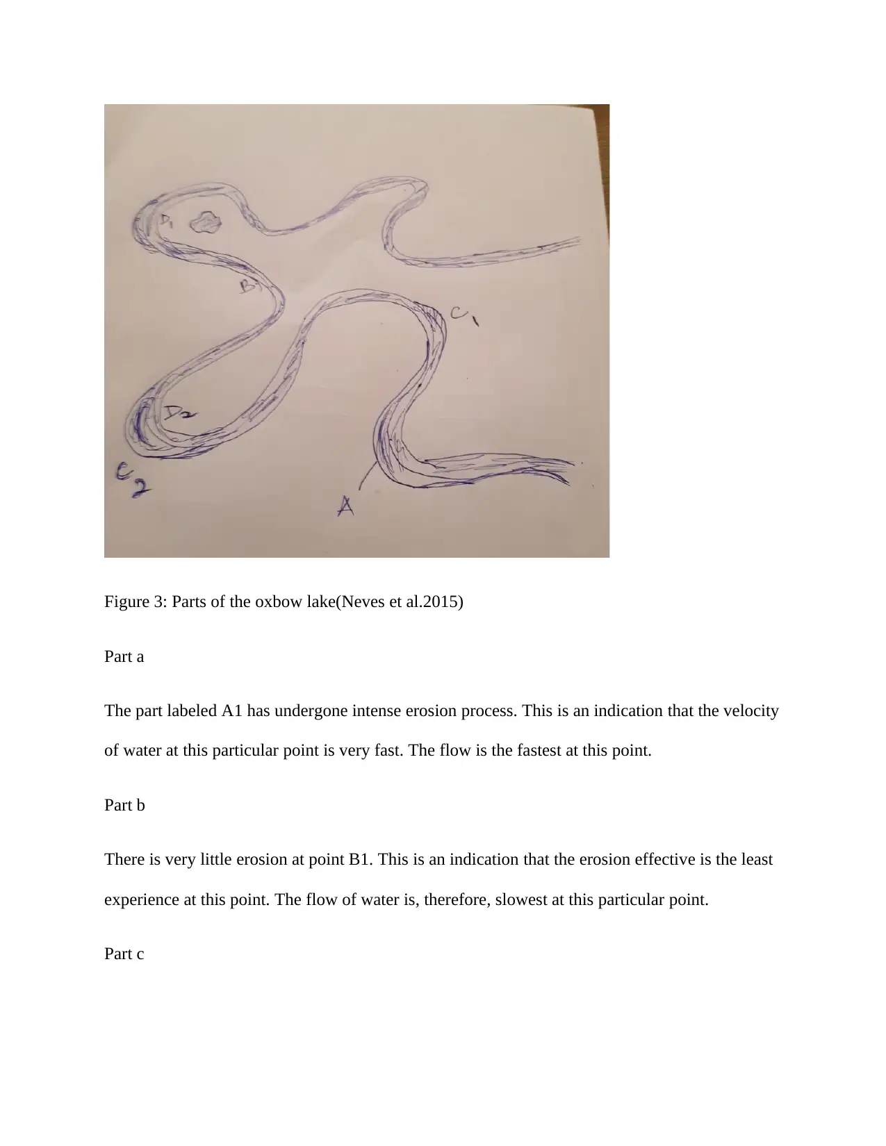
Figure 3: Parts of the oxbow lake(Neves et al.2015)
Part a
The part labeled A1 has undergone intense erosion process. This is an indication that the velocity
of water at this particular point is very fast. The flow is the fastest at this point.
Part b
There is very little erosion at point B1. This is an indication that the erosion effective is the least
experience at this point. The flow of water is, therefore, slowest at this particular point.
Part c
The points that have been marked C1and C2 are some of the parts that are experiencing erosion
as they are exposed to the outer bank of the river. It is important to note that the erosion will take
place effectively on the outer bank than the inner bank which is just characterized by deposition.
The velocity of water is greater at these points.
Part d
The deposition process is taking place at the points that are marked D1 and D2. At this points the
velocity of water is relatively low, thus most of the contents are deposited at these points.
Part e
Why deposition is occurring
As the rivers flow, it carries with a lot of materials ranging from silt, clay, sand, and gravel. The
capacity of the river to carry these materials will always be dependent on the velocity of water.
As the river meanders, there is variation in the velocity of the water. The velocity is greater on
the outer banks thus creating erosion effects on those parts. On the inner banks, the velocity is
very slow thus most of the components are deposited(Constantine et al 2014). This particular
pattern of events leads to the emergence of this kind of physical features.
Question 30
Part a
To be answered in the map.
Question 31
The contours that are widely placed illustrate a gentle slope. It is just the same way where closely
spaced contours indicate steep region.
Question 32
Part a
The width of river Genesee is narrow at the hilly areas. As the river descends down the slope, its
width becomes wider and wider. The slope of the terrain is depicted by the spread of the contour
lines in the map.
Part b
The difference in width is attributed to the variation in the speed of water. At the steep points or
hilly locations, the velocity of water is high and therefore the river tends to erode its bed making
it be deep instead of being wide. As the slope becomes gentle, the erosive effects on the bed
decreases as the volume of water accumulate making it spread out making the width wider.
Question 33
This is a typical example of a meandering river.
Question 34
The river flow in the south direction.
Question 35
What type of feature is Hemp Pond? It is an Oxbow lake.
Question 36
Paraphrase This Document
Need a fresh take? Get an instant paraphrase of this document with our AI Paraphraser
There is the likelihood of oxbow lake forming at these designated points considering that they
are almost necking and the river can easily cut through during the flooding season. The course of
the river cannot sustain this longer route anymore.
Figure 4: Parts predicated to be eroded(Neves et al.2015)
Question 37
The predicted location
#3 has been represented by the feature N in the map. The feature predicted at #1 has translated
into a feature I in the map.
Question 38
The use of the rivers to mark the boundaries may not be the best way to mark boundaries. This is
because as the river matures, it changes its course and therefore the boundaries that are marked
using the centers of the rivers may not be permanent. This basically means that there will forever
be seasonal disputes of the border between different states. When the references are made, the
current position of the river is never used but instead what was indicated in the map normally
take precedence.
.
References
Constantine, J.A., Dunne, T., Ahmed, J., Legleiter, C. and Lazarus, E.D., 2014. Sediment supply
as a driver of river meandering and floodplain evolution in the Amazon Basin. Nature
Geoscience, 7(12), p.899.
Neves, M.P., Delariva, R.L., Guimarães, A.T.B. and Sanches, P.V., 2015. Carnivory during
ontogeny of the Plagioscion squamosissimus: a successful non-native fish in a lentic
environment of the Upper Paraná River Basin. PloS one, 10(11), p.e0141651.
1 out of 13
Related Documents
Your All-in-One AI-Powered Toolkit for Academic Success.
+13062052269
info@desklib.com
Available 24*7 on WhatsApp / Email
Unlock your academic potential
© 2024 | Zucol Services PVT LTD | All rights reserved.