Geotechnical Investigation Report: Merri Catchment Area Rock Analysis
VerifiedAdded on 2023/06/08
|10
|1967
|475
Report
AI Summary
This report presents an analysis of the Merri Catchment Area, focusing on the geological properties of the underlying rocks. The primary rock types identified are marine limestone and sandstone, formed from sediments millions of years ago. The report investigates the strength parameters of...
Merri Catchment Area 1
MERRI CATCHMENT AREA
Module Name
Assessment Title
Student Numbe
The Date
MERRI CATCHMENT AREA
Module Name
Assessment Title
Student Numbe
The Date
Paraphrase This Document
Need a fresh take? Get an instant paraphrase of this document with our AI Paraphraser

Merri Catchment Area 2
Merri Catchment Area
Discussion of the findings
The most common type of rocks found in the research area in Merri Creek catchment
area marine limestone and sad-stone. These stones were formed from sediments millions of
years ago. Erosion has occurred over these sediments in the modern-day Merri Creek.
However, the rocks still defy their existence and as a result have led to this research
(Arroucau, Rawlinson and Sambridge, 2010).
Figure 1 The Site directions
Merri Catchment Area 3
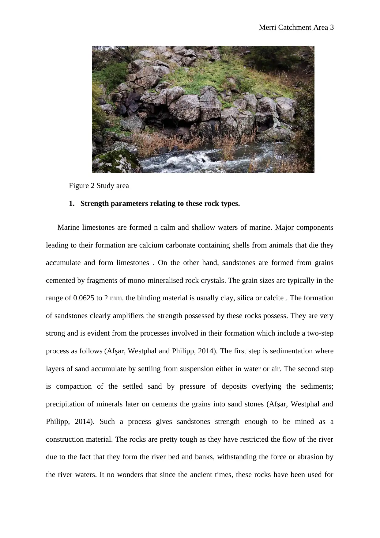
Figure 2 Study area
1. Strength parameters relating to these rock types.
Marine limestones are formed n calm and shallow waters of marine. Major components
leading to their formation are calcium carbonate containing shells from animals that die they
accumulate and form limestones . On the other hand, sandstones are formed from grains
cemented by fragments of mono-mineralised rock crystals. The grain sizes are typically in the
range of 0.0625 to 2 mm. the binding material is usually clay, silica or calcite . The formation
of sandstones clearly amplifiers the strength possessed by these rocks possess. They are very
strong and is evident from the processes involved in their formation which include a two-step
process as follows (Afşar, Westphal and Philipp, 2014). The first step is sedimentation where
layers of sand accumulate by settling from suspension either in water or air. The second step
is compaction of the settled sand by pressure of deposits overlying the sediments;
precipitation of minerals later on cements the grains into sand stones (Afşar, Westphal and
Philipp, 2014). Such a process gives sandstones strength enough to be mined as a
construction material. The rocks are pretty tough as they have restricted the flow of the river
due to the fact that they form the river bed and banks, withstanding the force or abrasion by
the river waters. It no wonders that since the ancient times, these rocks have been used for
⊘ This is a preview!⊘
Do you want full access?
Subscribe today to unlock all pages.
Trusted by 1+ million students worldwide
Merri Catchment Area 4
purposes of construction for houses and other ancient structures made by man including
curving’s (Amorosi, 2011).
2. The Rock Structure
In some areas for example the Melbourne Zone, the rock sediments thickness is up to 10
000 metres (Blöcher et al., 2014). These sedimentary formed rocks were uplifted after the
completion of compression and cementation. They were further folded to synclines and
anticlines (formation of sedimentary rocks). Adjacent areas of the area of study show that the
rocks were intruded by little masses of granites and tabular dykes. Compression with thick
beds of sandstones deform by brittle fracture causing them to bend around and in the process
deforming the less competent mudstones. Such competent mudstones and sediments are
responsible for such huge thickness in some areas as early on pointed out. In some place of
visit along the creek there are rocks that are broad with upright synclines and anticlines that
have fold axes striking South South West direction with spacing of 1 to 3 kilometres apart.
The beds have a dip of about 45’ to 70’. During the process of folding there were extensive
forces that led to fractures in form of faults and joints . There exist small faults with slips of
about one meter. There are shows of intense jointing in some nearby rocks (Blöcher et al.,
2014).
4. State of the Rocks
It is clear from the study area that the rocks under scrutiny that weathering has occurred
in this area. The form of the rocks was determined before the subsequent and the later
volcanic eruptions that released lava from surrounding hills and mountains (Burroughs,
1913). The lava flow covering parts of the rocks is younger as compared to the rocks which
as stated stand as the oldest formation in this part. There has been substantial weathering. The
joint planes are the major areas of progression for weathering (Burroughs, 1913). The
Paraphrase This Document
Need a fresh take? Get an instant paraphrase of this document with our AI Paraphraser
Merri Catchment Area 5
original rock fracturing is an indicator of the depth of weathering of the rock.is soft on the
surface from feeling. Weathering soils cover the impervious rock zones (Zhu et al., 2015).
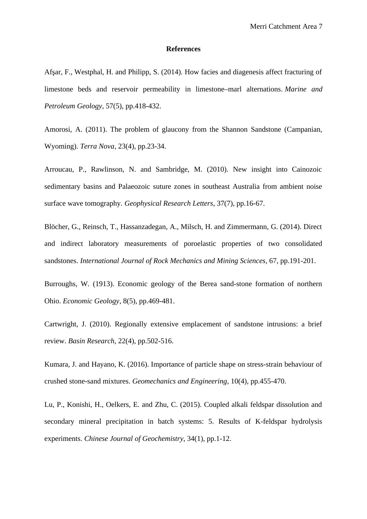
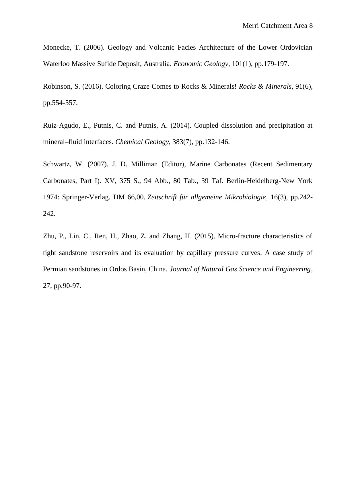
There is a domination of dark grey to brown clays on the rocks. These result from the
weathering of basalt which converts feldspathic minerals to clay. There is no quartz in the
rocks. There are also trees and vegetation growing from weak joints in the rocks indicating
that even the oldest and most strong forms of nature can still be broken by nature itself. The
forces of weathering are evident in the rocks as illustrated by these instances of vegetation
propagating along fault lines. All this information is illustrated by site images in the appendix
section of this paper (Cartwright, 2010).
5. Suitability of Rock Strata to withstand Forces in:
(iii) Construction of a weir across the stream
It is very possible to set up a concrete weir across the stream. The rocks have a very
low permeability of about 1.6 to 8.5 millidarcys. The sandstones are well compacted and
cemented due to the sedimentation process that occurred millions of years ago. Clay has
cemented the particles as early on stated making it less permeable yet very strong for use as a
construction material (Kumara and Hayano, 2016).
(iv) a multi-storey building on an adjacent site.
To set up a multistorey building on a site requires exhaustive research on the type of
rocks and soils in the site. The strength, water holding characteristics and durability of the
site needs to be determined (Zheng et al., 2014). In the area of study, sand stones dominate
the site. Setting up a multi-storey building would require a strong foundation to provide the
strength for holding the weight of the building. Construction materials in form of the sand
and limestone rocks will also be readily available for construction. It therefore makes setting
original rock fracturing is an indicator of the depth of weathering of the rock.is soft on the
surface from feeling. Weathering soils cover the impervious rock zones (Zhu et al., 2015).
There is a domination of dark grey to brown clays on the rocks. These result from the
weathering of basalt which converts feldspathic minerals to clay. There is no quartz in the
rocks. There are also trees and vegetation growing from weak joints in the rocks indicating
that even the oldest and most strong forms of nature can still be broken by nature itself. The
forces of weathering are evident in the rocks as illustrated by these instances of vegetation
propagating along fault lines. All this information is illustrated by site images in the appendix
section of this paper (Cartwright, 2010).
5. Suitability of Rock Strata to withstand Forces in:
(iii) Construction of a weir across the stream
It is very possible to set up a concrete weir across the stream. The rocks have a very
low permeability of about 1.6 to 8.5 millidarcys. The sandstones are well compacted and
cemented due to the sedimentation process that occurred millions of years ago. Clay has
cemented the particles as early on stated making it less permeable yet very strong for use as a
construction material (Kumara and Hayano, 2016).
(iv) a multi-storey building on an adjacent site.
To set up a multistorey building on a site requires exhaustive research on the type of
rocks and soils in the site. The strength, water holding characteristics and durability of the
site needs to be determined (Zheng et al., 2014). In the area of study, sand stones dominate
the site. Setting up a multi-storey building would require a strong foundation to provide the
strength for holding the weight of the building. Construction materials in form of the sand
and limestone rocks will also be readily available for construction. It therefore makes setting

Merri Catchment Area 6
up a multistorey building to the area adjacent to the study area very plausible. The rocks have
shown resistance to abrasion of the river, they have withstood the different erosion and
withering occurs slowly and very little over a long period of time (Lu et al., 2015).
Design Considerations
The sandstones have a very low permeability of about 1.6 to 8.5 millidarcys. In designing
a weir, considerations should also be given to the height of the weir crest. Critical flow must
be obtained in a weir and therefore the height should not be too low as it will cause the water
to pass without reaching the critical flow (Ruiz-Agudo, Putnis and Putnis, 2014).
Unnecessary backwater effect is inevitable if the design height is too high .The sedimentation
process used to make the sandstones involved setting layers of sand then compacting them
and further cementing with clay and other mineral material making it less permeable over a
long period of time (Monecke, 2006).
The building will have numerous loads in terms of live loads from the users; dead loads
for the material used for constructing and other factors for example earthquakes. The area
adjacent to the study area is suitable for construction of a multistore building because the
soils fulfil the design criteria (Schwartz, 2007). The rocks in the area have the right failure
bearing capacity; the soils are capable of supporting structural loads due to the hard strata. It
is evident by the rock types found in the area-sedimentary rock types hence will be able to
support the building due to the strength of such type of soils (Robinson, 2016).
⊘ This is a preview!⊘
Do you want full access?
Subscribe today to unlock all pages.
Trusted by 1+ million students worldwide
Merri Catchment Area 7
References
Afşar, F., Westphal, H. and Philipp, S. (2014). How facies and diagenesis affect fracturing of
limestone beds and reservoir permeability in limestone–marl alternations. Marine and
Petroleum Geology, 57(5), pp.418-432.
Amorosi, A. (2011). The problem of glaucony from the Shannon Sandstone (Campanian,
Wyoming). Terra Nova, 23(4), pp.23-34.
Arroucau, P., Rawlinson, N. and Sambridge, M. (2010). New insight into Cainozoic
sedimentary basins and Palaeozoic suture zones in southeast Australia from ambient noise
surface wave tomography. Geophysical Research Letters, 37(7), pp.16-67.
Blöcher, G., Reinsch, T., Hassanzadegan, A., Milsch, H. and Zimmermann, G. (2014). Direct
and indirect laboratory measurements of poroelastic properties of two consolidated
sandstones. International Journal of Rock Mechanics and Mining Sciences, 67, pp.191-201.
Burroughs, W. (1913). Economic geology of the Berea sand-stone formation of northern
Ohio. Economic Geology, 8(5), pp.469-481.
Cartwright, J. (2010). Regionally extensive emplacement of sandstone intrusions: a brief
review. Basin Research, 22(4), pp.502-516.
Kumara, J. and Hayano, K. (2016). Importance of particle shape on stress-strain behaviour of
crushed stone-sand mixtures. Geomechanics and Engineering, 10(4), pp.455-470.
Lu, P., Konishi, H., Oelkers, E. and Zhu, C. (2015). Coupled alkali feldspar dissolution and
secondary mineral precipitation in batch systems: 5. Results of K-feldspar hydrolysis
experiments. Chinese Journal of Geochemistry, 34(1), pp.1-12.
Paraphrase This Document
Need a fresh take? Get an instant paraphrase of this document with our AI Paraphraser
Merri Catchment Area 8
Monecke, T. (2006). Geology and Volcanic Facies Architecture of the Lower Ordovician
Waterloo Massive Sufide Deposit, Australia. Economic Geology, 101(1), pp.179-197.
Robinson, S. (2016). Coloring Craze Comes to Rocks & Minerals! Rocks & Minerals, 91(6),
pp.554-557.
Ruiz-Agudo, E., Putnis, C. and Putnis, A. (2014). Coupled dissolution and precipitation at
mineral–fluid interfaces. Chemical Geology, 383(7), pp.132-146.
Schwartz, W. (2007). J. D. Milliman (Editor), Marine Carbonates (Recent Sedimentary
Carbonates, Part I). XV, 375 S., 94 Abb., 80 Tab., 39 Taf. Berlin-Heidelberg-New York
1974: Springer-Verlag. DM 66,00. Zeitschrift für allgemeine Mikrobiologie, 16(3), pp.242-
242.
Zhu, P., Lin, C., Ren, H., Zhao, Z. and Zhang, H. (2015). Micro-fracture characteristics of
tight sandstone reservoirs and its evaluation by capillary pressure curves: A case study of
Permian sandstones in Ordos Basin, China. Journal of Natural Gas Science and Engineering,
27, pp.90-97.
Merri Catchment Area 9
Appendix
Figure 3 Sandstones showing the dark-grey matter of clay compaction
Figure 4 the effects of weathering showing cracks and fault lines
Appendix
Figure 3 Sandstones showing the dark-grey matter of clay compaction
Figure 4 the effects of weathering showing cracks and fault lines
⊘ This is a preview!⊘
Do you want full access?
Subscribe today to unlock all pages.
Trusted by 1+ million students worldwide

Merri Catchment Area 10
Figure 5 Deposition, sedimentation and erosion of the rocks over time
Figure 5 Deposition, sedimentation and erosion of the rocks over time
1 out of 10
Related Documents


Your All-in-One AI-Powered Toolkit for Academic Success.
+13062052269
info@desklib.com
Available 24*7 on WhatsApp / Email
![[object Object]](/_next/static/media/star-bottom.7253800d.svg)
Unlock your academic potential
© 2024 | Zucol Services PVT LTD | All rights reserved.