Project Preliminaries | Assessment1
VerifiedAdded on 2022/10/04
|10
|2044
|17
Assignment
AI Summary
Contribute Materials
Your contribution can guide someone’s learning journey. Share your
documents today.

Running head: PROJECT PRELIMINARIES 1
Civil Engineering
First Name Last Name
Institution
Civil Engineering
First Name Last Name
Institution
Secure Best Marks with AI Grader
Need help grading? Try our AI Grader for instant feedback on your assignments.
PROJECT PRELIMINARIES 2
Part B
Trade break up report on groundwork
Clarify exactly what was permitted in your earthworks pricing is very important consideration..
Whether costing and presenting a bid, the Contractor should always visit the site to be sure that
there are no irregularities they may see or need to know about before the final price is submitted.
If you're on a steep slope or near to a neighboring property boundary, mark whether you've
allowed the excavation to bench, shear wall retention, propping, and any other ' risk of collapse.
'If you have priced a crew / team of guys based on a certain level of efficiency or a number of
days to complete the excavation works, then it might be a good idea to ensure that your pricing
requires the workers to have direct, undisturbed access and that the pricing does not require
unexpected ground conditions, water pumping from excavations, etc. Please state on your quote /
tender the exact documents cited by the customer for pricing so that there is no confusion or
misunderstanding about the drawing of revisions / specifications, etc. When you wish to use
another subcontractor to conduct the works as the contractor / subcontractor, then make sure that
you have predetermined / set negotiated rates for both the hire / operator of the plant per hour,
etc.
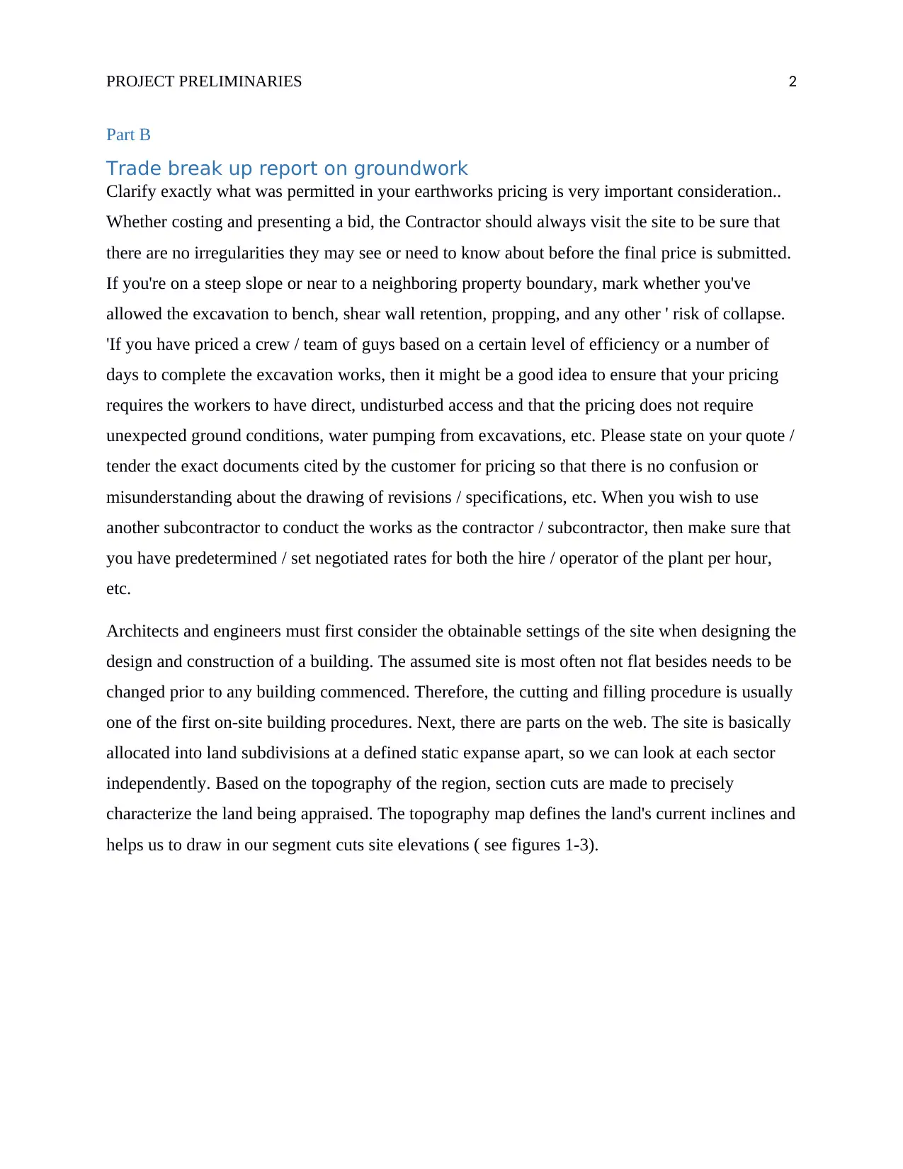
Architects and engineers must first consider the obtainable settings of the site when designing the
design and construction of a building. The assumed site is most often not flat besides needs to be
changed prior to any building commenced. Therefore, the cutting and filling procedure is usually
one of the first on-site building procedures. Next, there are parts on the web. The site is basically
allocated into land subdivisions at a defined static expanse apart, so we can look at each sector
independently. Based on the topography of the region, section cuts are made to precisely
characterize the land being appraised. The topography map defines the land's current inclines and
helps us to draw in our segment cuts site elevations ( see figures 1-3).
Part B
Trade break up report on groundwork
Clarify exactly what was permitted in your earthworks pricing is very important consideration..
Whether costing and presenting a bid, the Contractor should always visit the site to be sure that
there are no irregularities they may see or need to know about before the final price is submitted.
If you're on a steep slope or near to a neighboring property boundary, mark whether you've
allowed the excavation to bench, shear wall retention, propping, and any other ' risk of collapse.
'If you have priced a crew / team of guys based on a certain level of efficiency or a number of
days to complete the excavation works, then it might be a good idea to ensure that your pricing
requires the workers to have direct, undisturbed access and that the pricing does not require
unexpected ground conditions, water pumping from excavations, etc. Please state on your quote /
tender the exact documents cited by the customer for pricing so that there is no confusion or
misunderstanding about the drawing of revisions / specifications, etc. When you wish to use
another subcontractor to conduct the works as the contractor / subcontractor, then make sure that
you have predetermined / set negotiated rates for both the hire / operator of the plant per hour,
etc.
Architects and engineers must first consider the obtainable settings of the site when designing the
design and construction of a building. The assumed site is most often not flat besides needs to be
changed prior to any building commenced. Therefore, the cutting and filling procedure is usually
one of the first on-site building procedures. Next, there are parts on the web. The site is basically
allocated into land subdivisions at a defined static expanse apart, so we can look at each sector
independently. Based on the topography of the region, section cuts are made to precisely
characterize the land being appraised. The topography map defines the land's current inclines and
helps us to draw in our segment cuts site elevations ( see figures 1-3).
PROJECT PRELIMINARIES 3
Figure 1: Topography map.
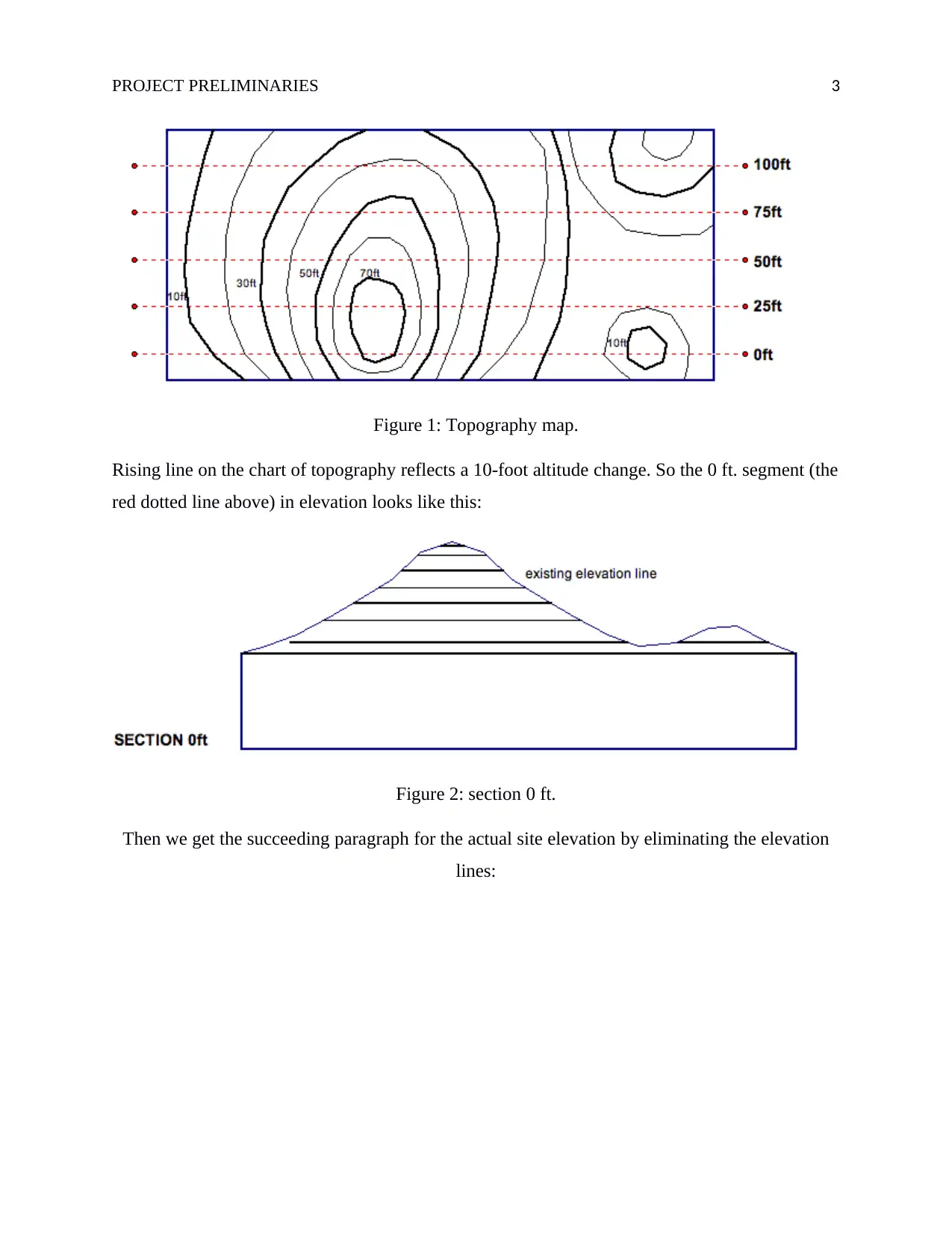
Rising line on the chart of topography reflects a 10-foot altitude change. So the 0 ft. segment (the
red dotted line above) in elevation looks like this:
Figure 2: section 0 ft.
Then we get the succeeding paragraph for the actual site elevation by eliminating the elevation
lines:
Figure 1: Topography map.
Rising line on the chart of topography reflects a 10-foot altitude change. So the 0 ft. segment (the
red dotted line above) in elevation looks like this:
Figure 2: section 0 ft.
Then we get the succeeding paragraph for the actual site elevation by eliminating the elevation
lines:
PROJECT PRELIMINARIES 4
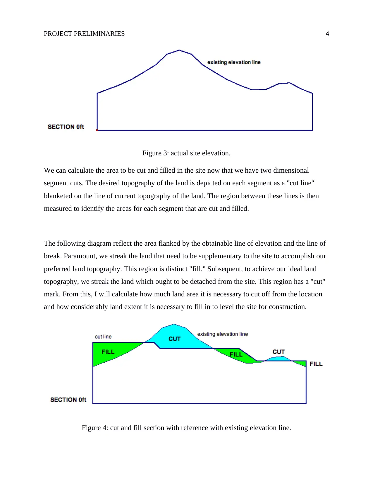
Figure 3: actual site elevation.
We can calculate the area to be cut and filled in the site now that we have two dimensional
segment cuts. The desired topography of the land is depicted on each segment as a "cut line"
blanketed on the line of current topography of the land. The region between these lines is then
measured to identify the areas for each segment that are cut and filled.
The following diagram reflect the area flanked by the obtainable line of elevation and the line of
break. Paramount, we streak the land that need to be supplementary to the site to accomplish our
preferred land topography. This region is distinct "fill." Subsequent, to achieve our ideal land
topography, we streak the land which ought to be detached from the site. This region has a "cut"
mark. From this, I will calculate how much land area it is necessary to cut off from the location
and how considerably land extent it is necessary to fill in to level the site for construction.
Figure 4: cut and fill section with reference with existing elevation line.
Secure Best Marks with AI Grader
Need help grading? Try our AI Grader for instant feedback on your assignments.
PROJECT PRELIMINARIES 5
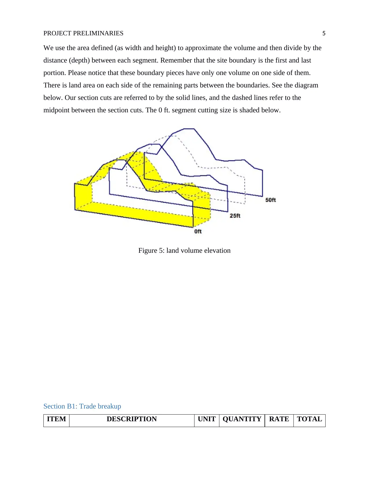
We use the area defined (as width and height) to approximate the volume and then divide by the
distance (depth) between each segment. Remember that the site boundary is the first and last
portion. Please notice that these boundary pieces have only one volume on one side of them.
There is land area on each side of the remaining parts between the boundaries. See the diagram
below. Our section cuts are referred to by the solid lines, and the dashed lines refer to the
midpoint between the section cuts. The 0 ft. segment cutting size is shaded below.
Figure 5: land volume elevation
Section B1: Trade breakup
ITEM DESCRIPTION UNIT QUANTITY RATE TOTAL
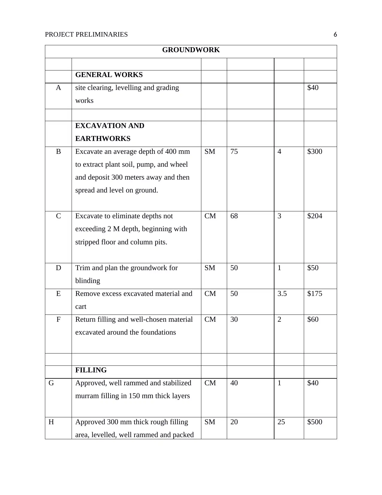
PROJECT PRELIMINARIES 6
GROUNDWORK
GENERAL WORKS
A site clearing, levelling and grading
works
$40
EXCAVATION AND
EARTHWORKS
B Excavate an average depth of 400 mm
to extract plant soil, pump, and wheel
and deposit 300 meters away and then
spread and level on ground.
SM 75 4 $300
C Excavate to eliminate depths not
exceeding 2 M depth, beginning with
stripped floor and column pits.
CM 68 3 $204
D Trim and plan the groundwork for
blinding
SM 50 1 $50
E Remove excess excavated material and
cart
CM 50 3.5 $175
F Return filling and well-chosen material
excavated around the foundations
CM 30 2 $60
FILLING
G Approved, well rammed and stabilized
murram filling in 150 mm thick layers
CM 40 1 $40
H Approved 300 mm thick rough filling
area, levelled, well rammed and packed
SM 20 25 $500
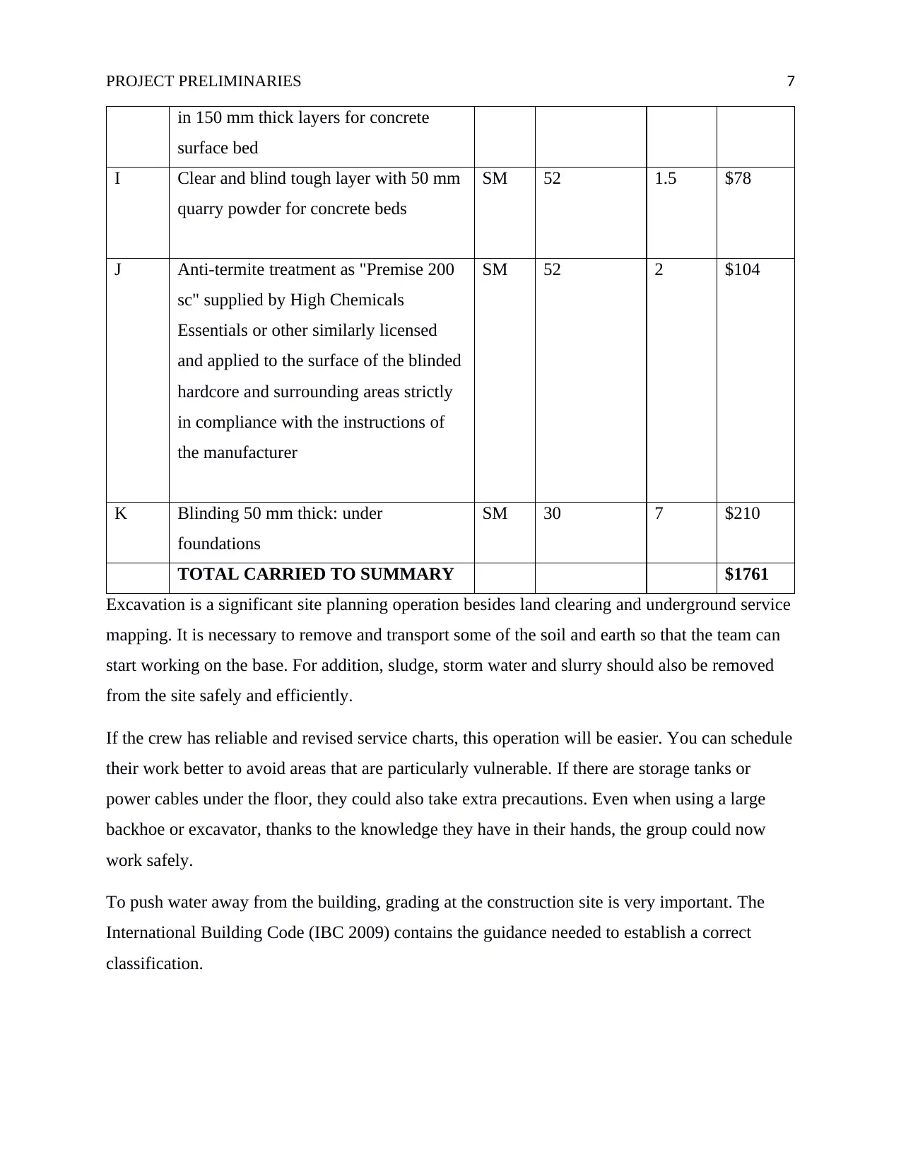
PROJECT PRELIMINARIES 7
in 150 mm thick layers for concrete
surface bed
I Clear and blind tough layer with 50 mm
quarry powder for concrete beds
SM 52 1.5 $78
J Anti-termite treatment as "Premise 200
sc" supplied by High Chemicals
Essentials or other similarly licensed
and applied to the surface of the blinded
hardcore and surrounding areas strictly
in compliance with the instructions of
the manufacturer
SM 52 2 $104
K Blinding 50 mm thick: under
foundations
SM 30 7 $210
TOTAL CARRIED TO SUMMARY $1761
Excavation is a significant site planning operation besides land clearing and underground service
mapping. It is necessary to remove and transport some of the soil and earth so that the team can
start working on the base. For addition, sludge, storm water and slurry should also be removed
from the site safely and efficiently.
If the crew has reliable and revised service charts, this operation will be easier. You can schedule
their work better to avoid areas that are particularly vulnerable. If there are storage tanks or
power cables under the floor, they could also take extra precautions. Even when using a large
backhoe or excavator, thanks to the knowledge they have in their hands, the group could now
work safely.
To push water away from the building, grading at the construction site is very important. The
International Building Code (IBC 2009) contains the guidance needed to establish a correct
classification.
Paraphrase This Document
Need a fresh take? Get an instant paraphrase of this document with our AI Paraphraser
PROJECT PRELIMINARIES 8
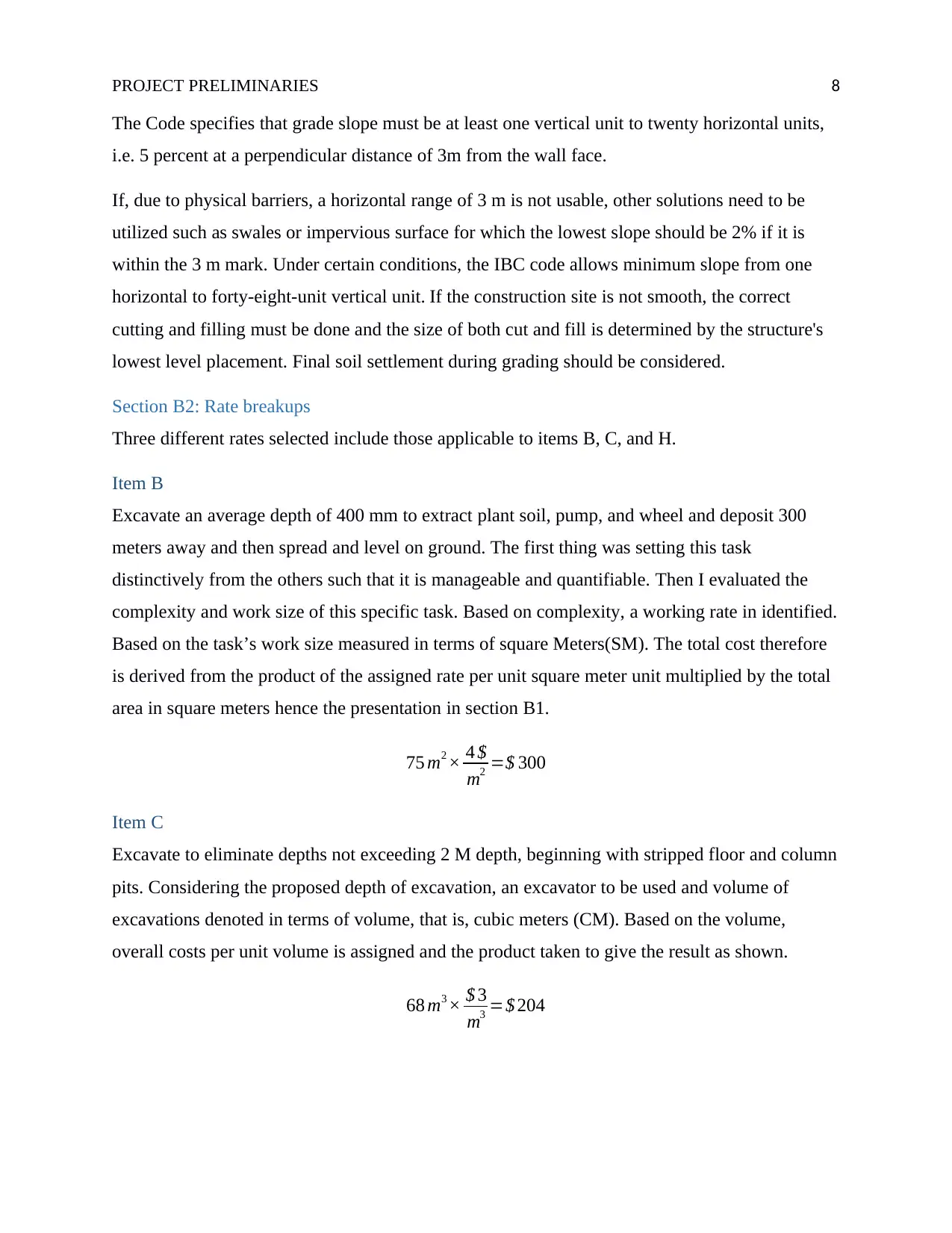
The Code specifies that grade slope must be at least one vertical unit to twenty horizontal units,
i.e. 5 percent at a perpendicular distance of 3m from the wall face.
If, due to physical barriers, a horizontal range of 3 m is not usable, other solutions need to be
utilized such as swales or impervious surface for which the lowest slope should be 2% if it is
within the 3 m mark. Under certain conditions, the IBC code allows minimum slope from one
horizontal to forty-eight-unit vertical unit. If the construction site is not smooth, the correct
cutting and filling must be done and the size of both cut and fill is determined by the structure's
lowest level placement. Final soil settlement during grading should be considered.
Section B2: Rate breakups
Three different rates selected include those applicable to items B, C, and H.
Item B
Excavate an average depth of 400 mm to extract plant soil, pump, and wheel and deposit 300
meters away and then spread and level on ground. The first thing was setting this task
distinctively from the others such that it is manageable and quantifiable. Then I evaluated the
complexity and work size of this specific task. Based on complexity, a working rate in identified.
Based on the task’s work size measured in terms of square Meters(SM). The total cost therefore
is derived from the product of the assigned rate per unit square meter unit multiplied by the total
area in square meters hence the presentation in section B1.
75 m2 × 4 $
m2 =$ 300
Item C
Excavate to eliminate depths not exceeding 2 M depth, beginning with stripped floor and column
pits. Considering the proposed depth of excavation, an excavator to be used and volume of
excavations denoted in terms of volume, that is, cubic meters (CM). Based on the volume,
overall costs per unit volume is assigned and the product taken to give the result as shown.
68 m3 × $ 3
m3 =$ 204
PROJECT PRELIMINARIES 9
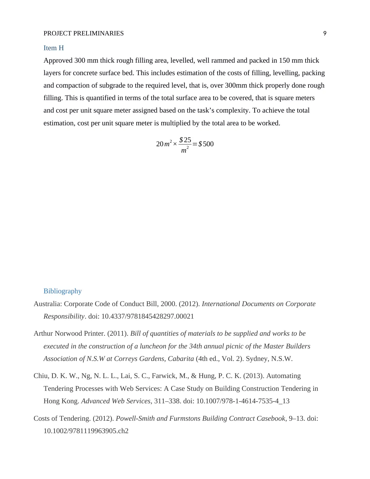
Item H
Approved 300 mm thick rough filling area, levelled, well rammed and packed in 150 mm thick
layers for concrete surface bed. This includes estimation of the costs of filling, levelling, packing
and compaction of subgrade to the required level, that is, over 300mm thick properly done rough
filling. This is quantified in terms of the total surface area to be covered, that is square meters
and cost per unit square meter assigned based on the task’s complexity. To achieve the total
estimation, cost per unit square meter is multiplied by the total area to be worked.
20 m2 × $ 25
m2 =$ 500
Bibliography
Australia: Corporate Code of Conduct Bill, 2000. (2012). International Documents on Corporate
Responsibility. doi: 10.4337/9781845428297.00021
Arthur Norwood Printer. (2011). Bill of quantities of materials to be supplied and works to be
executed in the construction of a luncheon for the 34th annual picnic of the Master Builders
Association of N.S.W at Correys Gardens, Cabarita (4th ed., Vol. 2). Sydney, N.S.W.
Chiu, D. K. W., Ng, N. L. L., Lai, S. C., Farwick, M., & Hung, P. C. K. (2013). Automating
Tendering Processes with Web Services: A Case Study on Building Construction Tendering in
Hong Kong. Advanced Web Services, 311–338. doi: 10.1007/978-1-4614-7535-4_13
Costs of Tendering. (2012). Powell-Smith and Furmstons Building Contract Casebook, 9–13. doi:
10.1002/9781119963905.ch2
PROJECT PRELIMINARIES 10
Du, T. C. (2009). Building an automatic e-tendering system on the Semantic Web. Decision Support
Systems, 47(1), 13–21. doi: 10.1016/j.dss.2008.12.009
Macdonald, H. S. (2013). Bill of quantities for erection and completion of administration building at
corner of Ann and Turbot Streets, Brisbane for the Southern Electric Authority of Queensland. .
Milligan, V., & Randolph, B. (2015). Australia. Management of Privatised Housing, 19–43. doi:
10.1002/9781444322613.ch2
Seeley, I. H., & Winfield, R. (2011). Bill Preparation and Production. Building Quantities
Explained, 344–378. doi: 10.1007/978-1-349-14653-6_17
Smith, R. C. (2013). Estimating and Tendering for Building Work. doi: 10.4324/9781315838403
The Authors. (2017). Basics Tendering. doi: 10.1515/9783035613056-011
Turner, A. (2014). Tendering: Contractors Policy, Examination and Contract. Building Contract
Claims and Disputes, 27–40. doi: 10.4324/9781315842462-3
Zima, K. (2017). Impact of information included in the BIM on preparation of Bill of Quantities.
Procedia Engineering, 208, 203–210. doi: 10.1016/j.proeng.2017.11.039
1 out of 10
Your All-in-One AI-Powered Toolkit for Academic Success.
+13062052269
info@desklib.com
Available 24*7 on WhatsApp / Email
![[object Object]](/_next/static/media/star-bottom.7253800d.svg)
Unlock your academic potential
© 2024 | Zucol Services PVT LTD | All rights reserved.