Regional Geography of Canada (Geog. 2221)
VerifiedAdded on 2022/10/31
|10
|2273
|323
AI Summary
This report discusses the regional geography of Canada, specifically Quebec, and its economic activities, natural resources, demographics, and future outlook. The report also touches on the concept of core-periphery regions in Canada and how Quebec fits into this model. The paper concludes with suggestions for mitigating potential challenges that may arise from Quebec's growing population and economy.
Contribute Materials
Your contribution can guide someone’s learning journey. Share your
documents today.
1Running head: REGIONAL GEOGRAPHY OF CANADA (GEOG. 2221)
Regional Geography of Canada (Geog. 2221)
[Name]
[Institutional Affiliation]
Regional Geography of Canada (Geog. 2221)
[Name]
[Institutional Affiliation]
Secure Best Marks with AI Grader
Need help grading? Try our AI Grader for instant feedback on your assignments.
2REGIONAL GEOGRAPHY OF CANADA (GEOG. 2221)
Regional Report
Introduction
This day and age, and the over the years the world has been divided into regions
and boundary also and the discourse of core-periphery concept has continued to grow. The
division is majorly on socio-economic values which causes the regional boundaries, and the
global scales. The cores of the world are said to be the dominant countries that had exploited
the peripheries during the colonials to reap economically from them. Core boundaries have
since continued to grow economically, socially and have been said to have a rich culture. The
difference is development between the peripherals and the core is development, historical-
cultural locations and the political decisions made or the policies that have been made
administratively.
The concept of cores and peripheries do exist in Canada as well, where the
parameters of distinguishing them are the heartland and the hinterland which depends more
on the locations of the regions geographically. Another parameter of classifying the core-
peripheries, are the sizes of the regions, physical features that exist in the environments, the
access to resources, employment opportunities (whether secondary or tertiary) and the
population within those territories (Yeates, 2013). The Atlantic coast, along the Great Lakes,
along the St. Lawrence river are where British and the French cores sprung up due to the
above-mentioned factors. When agriculture was beginning to take centre stage, which
brought up the Prairie settlement, that brought in an influx migrations of the European
nationals, which was a core-peripherals migration according to (Berry, 1988).
There are two such places classified as core regions of Canada, that is Ontario
and Quebec (Smith, 2010), the other remaining regions, like Atlantic Canada, West Canada,
British Columbia, and the Territorial North (classified as the fault lines according to (Bone,
3REGIONAL GEOGRAPHY OF CANADA (GEOG. 2221)
2012)). This paper is meant to focus on Quebec as a city in Canada and classified as a core
for that matter. The paper will elaborate on the economic activities involved in that city,
natural resources found in that city, the demographics of the city, and how the city will look
in a decade to come.
Quebec
Geographical
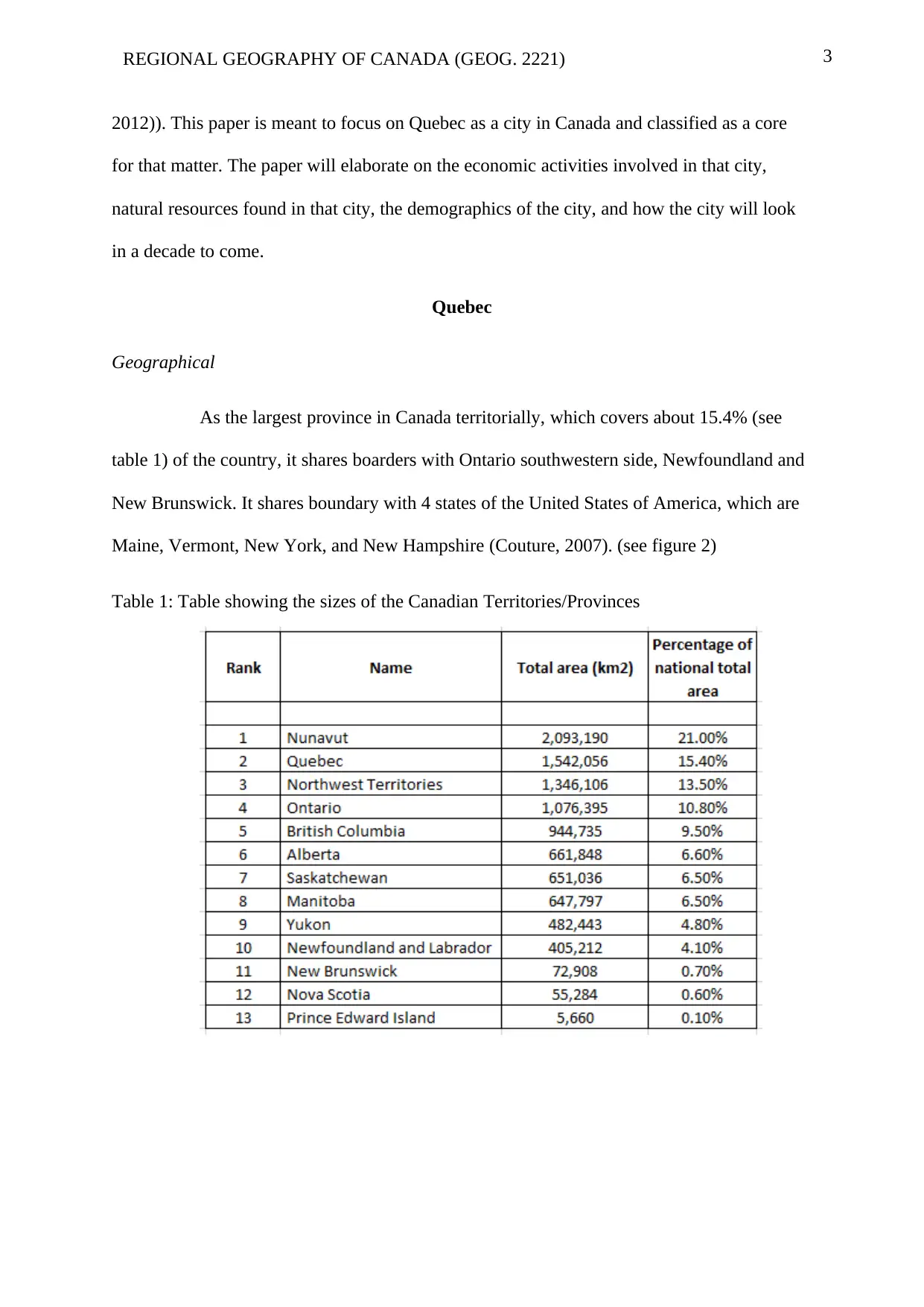
As the largest province in Canada territorially, which covers about 15.4% (see
table 1) of the country, it shares boarders with Ontario southwestern side, Newfoundland and
New Brunswick. It shares boundary with 4 states of the United States of America, which are
Maine, Vermont, New York, and New Hampshire (Couture, 2007). (see figure 2)
Table 1: Table showing the sizes of the Canadian Territories/Provinces
2012)). This paper is meant to focus on Quebec as a city in Canada and classified as a core
for that matter. The paper will elaborate on the economic activities involved in that city,
natural resources found in that city, the demographics of the city, and how the city will look
in a decade to come.
Quebec
Geographical
As the largest province in Canada territorially, which covers about 15.4% (see
table 1) of the country, it shares boarders with Ontario southwestern side, Newfoundland and
New Brunswick. It shares boundary with 4 states of the United States of America, which are
Maine, Vermont, New York, and New Hampshire (Couture, 2007). (see figure 2)
Table 1: Table showing the sizes of the Canadian Territories/Provinces
4REGIONAL GEOGRAPHY OF CANADA (GEOG. 2221)
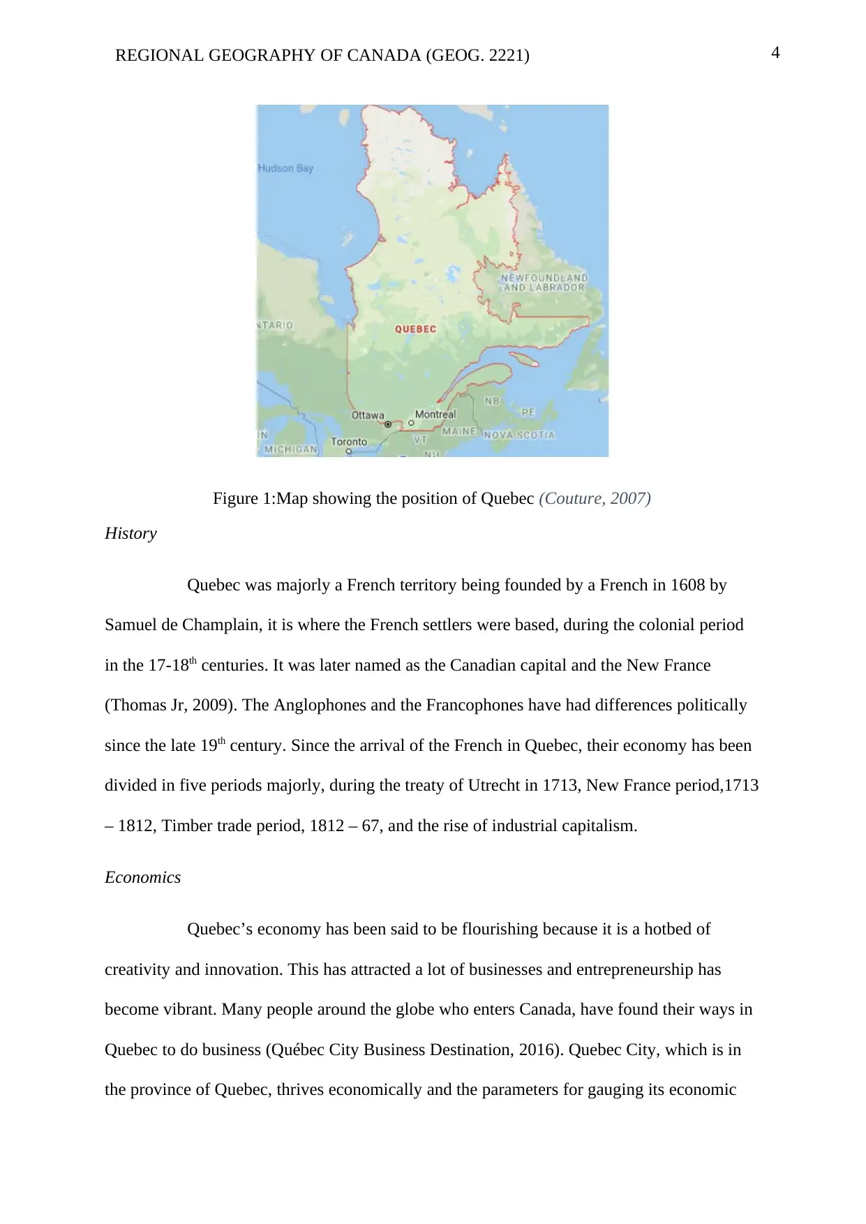
Figure 1:Map showing the position of Quebec (Couture, 2007)
History
Quebec was majorly a French territory being founded by a French in 1608 by
Samuel de Champlain, it is where the French settlers were based, during the colonial period
in the 17-18th centuries. It was later named as the Canadian capital and the New France
(Thomas Jr, 2009). The Anglophones and the Francophones have had differences politically
since the late 19th century. Since the arrival of the French in Quebec, their economy has been
divided in five periods majorly, during the treaty of Utrecht in 1713, New France period,1713
– 1812, Timber trade period, 1812 – 67, and the rise of industrial capitalism.
Economics
Quebec’s economy has been said to be flourishing because it is a hotbed of
creativity and innovation. This has attracted a lot of businesses and entrepreneurship has
become vibrant. Many people around the globe who enters Canada, have found their ways in
Quebec to do business (Québec City Business Destination, 2016). Quebec City, which is in
the province of Quebec, thrives economically and the parameters for gauging its economic
Secure Best Marks with AI Grader
Need help grading? Try our AI Grader for instant feedback on your assignments.
5REGIONAL GEOGRAPHY OF CANADA (GEOG. 2221)
power are the economic growth rate, purchasing power, investment, labour market, and the
demographics (Quebec International, 2019). The major economic activities of Quebec are:
Agriculture, the agricultural land of Quebec was protected by the government
between 1972 and 78, where the farmers were supplied from markets since the 80’s.
Quebec farmers have continued to dominate the farming of Pork and dairy products in
the 19th century. When specialization begun, agriculture increasingly became
industrialized and the production rate was increased (Taylor & Dick,, 2015).
Industries, these are majorly involved in manufacturing, electric power generation,
production of paper and pulp. The manufacturing sectors takes about 25% of the
manufacturing taking place in Canada.
Forestry, Quebec has the second largest forest cover in Canada with this coverage
dominated by the Northern territories. It covers about 825,000km2 of trees, that are
provincially owned, though a larger part of it is for the Aboriginal people (Ministère
Des, 2007). For more see the next section
Fisheries, there are around 4,200 people who are full-time fishermen in different
locations of Quebec. The fishing mostly takes place in the Atlantic and the fish that
are often caught are the molluscs and the crustaceans (Mackenzie, 2015).
Energy, Quebec produces the largest electricity in Canada, generating about 36,068
MW of electricity, which is more than 30% of the electricity generated in Canada
(Marsh, 2015).
Transportation which occurs through the St. Lawrence river and Montreal. Other
transportation is through the air transport, Air Canada whose head offices are in
Montreal.
6REGIONAL GEOGRAPHY OF CANADA (GEOG. 2221)
Forestry in Quebec
Forest or trees are a major natural resource that are produced by Quebec, and is
important in the manufacturing industry of Canada. In 2007, it was estimated that forestry
industry a lone had employed up to 209,940 both citizens and non-citizens across the country,
out of this number about 11,565 were indigenous people. Forestry contributes to about 7.2%
of the exports from Canada. Forestry, generated above $1.4 billion in revenue for the central
government and the provincial government, which contributed about $24.6 billion to the
economy of the country in 2017. The export from the forest products in the year 2017 were in
form of: softwood, wood pulp, paper for printing and writing, newsprint paper, and other
categories of products, where exports happen in 29%, 23%, 6%, 6%, and 29% respectively
(National Forestry Database, 2018).
Population
According to Statistics Canada, there are around 8,164,361 people dwelling in
Quebec, which is an increase from 7,903,001, around 3.3%. this means the population in this
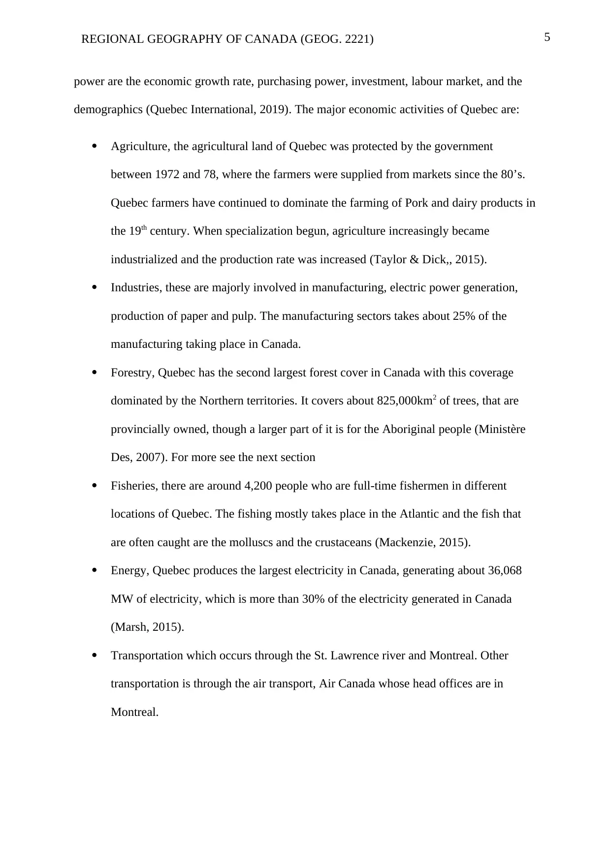
region is increasing, though a small rate, the general data of 2011 is summarised in figure 2.
(Statistics Canada, 2018). Quebec has a higher fertility rate than the Canadian average of a
round 1.69 children per woman, but the replacement rate is higher than this, which is 2.1%.
Quebec is a crowded province with a population density of 8 people per km2 which accounts
to 24% of the population of the entire country (World Population Review, 2019). According
to statistics Canada, the population growth is occurring at Montreal, because of it is more
urbanized than other areas in the province (Statistics Canada, 2018). Quebec is generally a
core area with it being the second populous area than the rest in Canada. That is why Quebec
is the highest economic area than the other provinces in Canada, with an employment rate of
67.4%, GDP per capita of $43,742 and a GDP growth of 2.4% (Quebec International, 2019).
Forestry in Quebec
Forest or trees are a major natural resource that are produced by Quebec, and is
important in the manufacturing industry of Canada. In 2007, it was estimated that forestry
industry a lone had employed up to 209,940 both citizens and non-citizens across the country,
out of this number about 11,565 were indigenous people. Forestry contributes to about 7.2%
of the exports from Canada. Forestry, generated above $1.4 billion in revenue for the central
government and the provincial government, which contributed about $24.6 billion to the
economy of the country in 2017. The export from the forest products in the year 2017 were in
form of: softwood, wood pulp, paper for printing and writing, newsprint paper, and other
categories of products, where exports happen in 29%, 23%, 6%, 6%, and 29% respectively
(National Forestry Database, 2018).
Population
According to Statistics Canada, there are around 8,164,361 people dwelling in
Quebec, which is an increase from 7,903,001, around 3.3%. this means the population in this
region is increasing, though a small rate, the general data of 2011 is summarised in figure 2.
(Statistics Canada, 2018). Quebec has a higher fertility rate than the Canadian average of a
round 1.69 children per woman, but the replacement rate is higher than this, which is 2.1%.
Quebec is a crowded province with a population density of 8 people per km2 which accounts
to 24% of the population of the entire country (World Population Review, 2019). According
to statistics Canada, the population growth is occurring at Montreal, because of it is more
urbanized than other areas in the province (Statistics Canada, 2018). Quebec is generally a
core area with it being the second populous area than the rest in Canada. That is why Quebec
is the highest economic area than the other provinces in Canada, with an employment rate of
67.4%, GDP per capita of $43,742 and a GDP growth of 2.4% (Quebec International, 2019).
7REGIONAL GEOGRAPHY OF CANADA (GEOG. 2221)
Figure 2: Estimated population growth in the year 2036 compared with 2011 (Jean-
Dominique, Malenfant, & MacIsaa, 2017)
Fault lines
Theoretically, Canada is divided into regions by (Bone, 2012), due to their
historical backgrounds, economic indications, social and demographics. The fault lines Bone
believed that will shift just like the geographical fault lines. The movements of these fault
lines are based on the parameters mentioned above. Quebec is just a region as its own, Bone
classified it just a “Quebec” when forming the six different regions. With the economic
growth, currently the highest in Canada, migration is imminent in the coming future, say 10
years. With migrations, comes with its increased industrialization because market
availability. This fault line will increase or expand due to those factors.
Conclusion
The statistical data shows that Quebec is growing in population, economically
and birth rate or fertility rate is high as well. This naturally will mean that it will be a
crowded place and that there might be a population explosion. This brings with it benefits as
Paraphrase This Document
Need a fresh take? Get an instant paraphrase of this document with our AI Paraphraser
8REGIONAL GEOGRAPHY OF CANADA (GEOG. 2221)
it brings challenges as well, in terms of resource allocation and market availability. Not to
mention that the rate of employment is dwindling, from the survey in the previous years and
the one carried in 2016 is evident of that. This will mean that with time, the people might face
a challenge of higher unemployment rates. With high population, also the natural resources
shall be strained, especially trees, which might bring a problem of desertification. This factor
coupled by the fact that housing deficiency might be faced and therefore they might be forced
to cut down trees to meet this demand.
To mitigate these issues, one knows that the buck stops with the provincial
government and the national government. One question is why is the migration taking place
in the first place? The economic value or high levels of opportunities and good lifestyle/good
living standards. This usually comes with economic empowerment which can be enforced by
government policies. The province of Quebec can change their laws on those who want to
migrate to that place, so that there’s control of the immigrants in the province. Increase of
taxation on certain things, will discourage many people from living in Quebec. This will
force the traders to increase the prices of their goods thereby making the living standards high
which in turn reduces the population.
9REGIONAL GEOGRAPHY OF CANADA (GEOG. 2221)
References
Berry, B. J. (1988). ‘Migration reversals in perspective: The long-wave evidence.
International Regional Science Review, 245-51.
Bone, R. M. (2012). The Canadian north: Issues and challenges. Ontario: Oxford University
Press.
Couture, C. (2007, September 30). Quebec. Retrieved from The Canadian Encyclopedia:
https://www.thecanadianencyclopedia.ca/en/article/quebec
Jean-Dominique, M., Malenfant, C. É., & MacIsaa, S. (2017, January 25). Immigration and
Diversity: Population Projections for Canada and its Regions, 2011 to 2036. Retrieved
from Statistics Canada: https://www150.statcan.gc.ca/n1/pub/91-551-x/91-551-
x2017001-eng.htm
Mackenzie, W. C. (2015, March 4). Fisheries. Retrieved from The Canadian Encyclopedia:
https://www.thecanadianencyclopedia.ca/en/article/fisheries
Marsh, J. H. (2015, March 4). James Bay Project. Retrieved from The Canadian
Encyclopedia: https://www.thecanadianencyclopedia.ca/en/article/james-bay-project
Ministère Des. (2007). Reforestation. The Canadian Encyclopedia.
National Forestry Database. (2018). Revenues. Quebec: Provincial Crown land, by
jurisdiction.
Québec City Business Destination. (2016, August 10). Québec City: Economic strength
unlike anywhere else in Canada. Retrieved from Quebec City: Business Destination:
https://blogue.quebec-cite.com/en/business/key-industries/quebec-city-economic-
strength/
10REGIONAL GEOGRAPHY OF CANADA (GEOG. 2221)
Quebec International. (2019, August). QUÉBEC CITY ECONOMIC STATISTICS.
Retrieved from Quebec International Economic Deevelopment:
https://www.quebecinternational.ca/en/quebec-economic-statistics
Smith, J. D. (2010). 5 regions of canada. Ontario.
Statistics Canada. (2018). 2016 Census of Population . Quebec: Population Centre.
Taylor, J., & Dick,, L. (2015). History of Agriculture to the Second World War.
Thomas Jr, c. (2009). Writing the Convent in New France: The Colonialist Rhetoric of
Canadian Nuns. Quebec Studies, 3-23.
World Population Review. (2019). Quebec Population 2019. Los Angeles, CA: World
Population Review.
Yeates, M. (2013). THE CORE/PERIPHERY MODEL AND URBAN DEVELOPMENT IN
CENTRAL CANADA. Urban Geography, 6(2), 101-121.
1 out of 10
Your All-in-One AI-Powered Toolkit for Academic Success.
+13062052269
info@desklib.com
Available 24*7 on WhatsApp / Email
![[object Object]](/_next/static/media/star-bottom.7253800d.svg)
Unlock your academic potential
© 2024 | Zucol Services PVT LTD | All rights reserved.