Vegetation Management Plan Report: 9 Ross Place, Kellyville, 2019
VerifiedAdded on 2020/10/22
|33
|3004
|352
Report
AI Summary
This report details a vegetation management plan for 9 Ross Place, Kellyville, focusing on environmental management and ecological health. The report begins with an introduction to research and development in the context of vegetation management, followed by site information, including location, size, and vegetation type. It outlines stakeholders, objectives (biodiversity conservation, pest species control), project scope, budget, and time frames. The second part of the report details the data collection plan, soil profiles, land use, and legislation relevant to the site. The report includes site maps, species lists, and considerations for work health and safety. The plan aims to improve ecological health, maintain habitat values, and promote community education. Data collection includes soil analysis, land use zoning, and biodiversity assessments. The budget covers weed control, planting, and overall project costs, with time frames specified. The report provides a comprehensive overview of the vegetation management plan, including data analysis, site-specific details, and management strategies.
Riccardo Campilongo
Ass. 1 - Develop a design brief and research site
(AHCLPW501 Develop a management plan for a
designated area)
1
Ass. 1 - Develop a design brief and research site
(AHCLPW501 Develop a management plan for a
designated area)
1
Paraphrase This Document
Need a fresh take? Get an instant paraphrase of this document with our AI Paraphraser
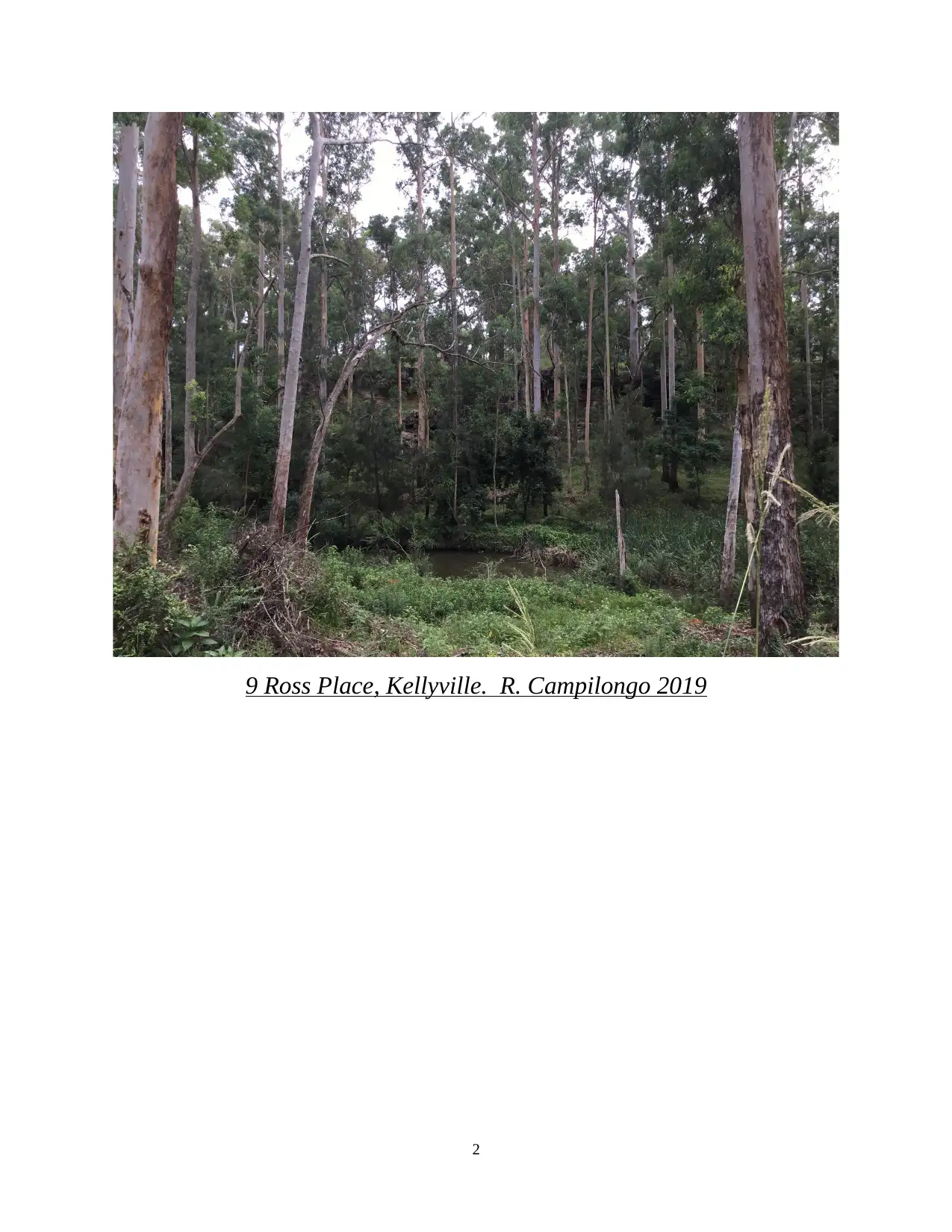
9 Ross Place, Kellyville. R. Campilongo 2019
2
2
TABLE OF CONTENTS
INTRODUCTION.........................................................................................................................................................3
PART- 1.........................................................................................................................................................................3
1. Site information.....................................................................................................................................................3
2. Stakeholders..........................................................................................................................................................4
3. Overall objectives behind developing a plan of management...............................................................................4
4. Scope of project.....................................................................................................................................................6
5. Budget...................................................................................................................................................................6
6. Time frames...........................................................................................................................................................7
7. Obtain any existing data about the site..................................................................................................................7
Part 2............................................................................................................................................................................20
Section- 1 Data collection plan...............................................................................................................................20
Section- 2 Data report.............................................................................................................................................21
CONCLUSION...........................................................................................................................................................30
REFERENCES............................................................................................................................................................31
3
⊘ This is a preview!⊘
Do you want full access?
Subscribe today to unlock all pages.

Trusted by 1+ million students worldwide
INTRODUCTION
Research and development is a process that help organisations to increase their
production. It also implements all the innovative ideas to create new technologies. This report
will discuss about the vegetation management prepared by the government of Australia. This
site is basically located within The Hills Shire Council local government areas. This assignment
will outline all the information regarding site, name, and description of land, location, project
plan, objectives, time frame, overall budget and images of site. Furthermore, this report will
discuss about planning and strategies which can assist in managing overall details of site related
to the development.
PART- 1
1. Site information
Site name- Vegetation Management plan 9 Ross Place, Kellyville.
Site description-
The research and planning are one of the most important factors required for
determining information related to the site such as locations, property, topographical map,
subjects and elevation etc. The study is about the 9 Ross place, Kellyville (Snavely and et.al.,
2019).
Location 9 Ross Place, Kellyville
Size of property 670000meter square or 6.5 h approximate
Subject 26100-meter Square and 2.5 ha
Elevation 130 – 100 m
Vegetation type determine within the property Scattered trees, Grassland and sandstone wood
land.
The Sydney Sandstone Gully Forest (SSGF),
River-flat Eucalypt Forest (RFEF).
Topographical map Sydney – 1:30000
4
Paraphrase This Document
Need a fresh take? Get an instant paraphrase of this document with our AI Paraphraser
Aspect South- North
LGA (Local government agency) The Hills Shire Council
Location details-
This site is basically located on the hill shire council which is Australian local
government area at south and north areas of 9 Ross place, Kellyville. The land is basically
maintained by local government agency that consists of vegetation and residential dwellings
(Bell, 2018).
Land history management-
The vegetation management site is located in 9 Ross place, Kellyville. In 2018, the site was
mainly focused towards the areas and location. It is also beneficial for the regenerating and
replanting the plants and is beneficial for the purpose of planting (Cho, 2018). It is useful for
regenerating and replanting properly. It is also useful for protecting all the weed species. There
are different methods to manage the history of land.
Weed control method
Infill planting
2. Stakeholders
Name and contact of client The Hill Shire Council
Other relevant stakeholders
Contractor
Industry trade group
Regulatory agencies
Supplier
Distributors
3. Overall objectives behind developing a plan of management
Objectives Specified in client
To improve the ecological health and integrate with the riparian corridor.
To enhance and maintain the habitat value of species.
5
To promote the community of education towards the vegetation management plan areas. To maintain the vegetation plans to store clean water within the vegetation management
plan area.
Biodiversity conservation
The conservation of biodiversity is important for the environmental because there are
various types of biological organisms that exists in the environment (Micallef and Rangel-
Buitrago, 2019). In the term of ecological environment, there are various type of living species
such as animal, plans and microbes, etc. Main aim of Biodiversity conservation is to protect,
manage and enhance biodiversity (Bibbings, Bieluga and Mills, 2018).
Pest species control
Pest species control is required for maintaining and controlling living organism. Owner
of the land is responsible for the protection of the land in a responsible manner. Land owner
takes necessary decisions in order to maintain the soil erosion on the site. (Lüdeke-Freund and
et.al., 2019). It is important to construct and sediment fencing to exclude the rabbit. The owner
also conducted programs that might be useful for the site in order to manage vegetation areas.
They always monitor the evidence of species at the site.
Heritage and culture issues
It is recommended for regenerating and replanting on the site. The worker always
participate for maintain the heritage culture of site. They also used the precautionary approach to
adopt that help for minimise the risk of damaging the culture.
Environmental impacts
The Amendment of abiotic condition are impacted on the natural regeneration. It also
applied the areas to perceive the native plant resilience in the form of propagates and soil stored.
The Australian association always try to restore the bushland and there main aim to increase the
growth of site. It has ability to migrate on the site by using suitable management.
6
⊘ This is a preview!⊘
Do you want full access?
Subscribe today to unlock all pages.

Trusted by 1+ million students worldwide
4. Scope of project
The scope of project is to create ecological healthy environment that can help in
maintaining the habitat values of species. It is beneficial for communities to make plans in order
to maintain their site areas effectively and efficiently. (Lewis and Axel, 2019). It is important to
grow more tree and plants at the site for better environmental conditions. The main objective of
this project to maintain the environmental condition properly. The plan will be executed on the
basis of need and requirement. Important steps for making project development plan are:
Planning
Analysing activities
Allocation of resources
Determining time-scale
Assigning roles and responsibilities
Execution of activities
Control and evaluation
5. Budget
The actual cost of project is appropriately $180,999 exclusive of CPI and GST. This is
the overall cost calculated for the entire vegetation management plan. This cost is inversely
proportional to the commercial cost of project (Bichard and et.al., 2018). Wood control
technique is implemented for the treatment of vegetation management plan. There are
approximate 16,865 plant necessary for managing the environmental condition of site. The total
cost of vegetation is appropriately $48,325.
7
Paraphrase This Document
Need a fresh take? Get an instant paraphrase of this document with our AI Paraphraser
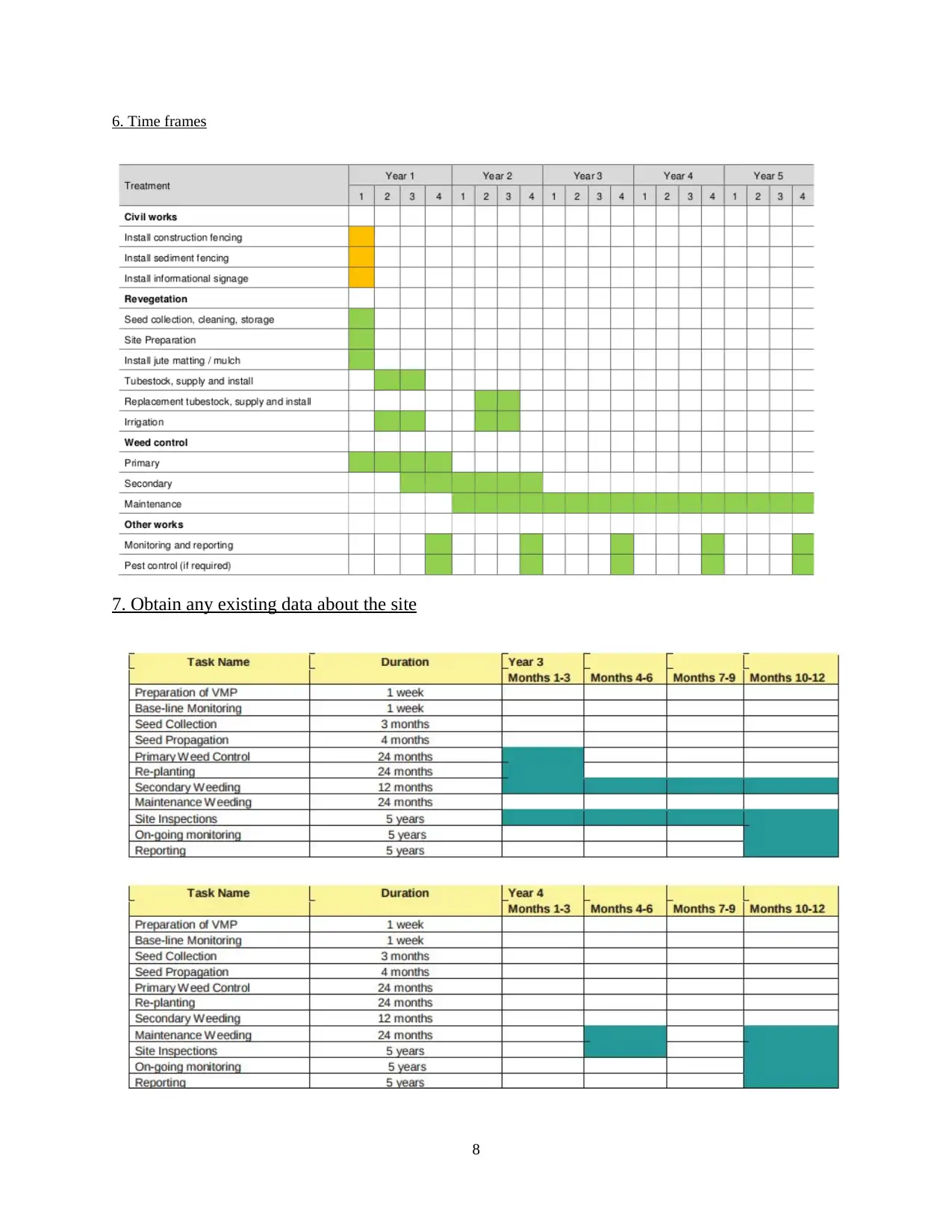
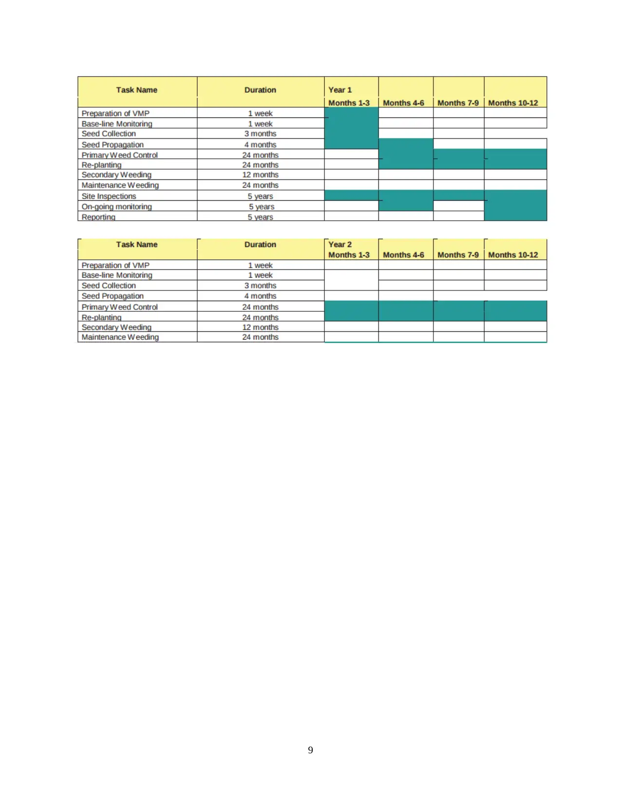
6. Time frames
7. Obtain any existing data about the site
8
7. Obtain any existing data about the site
8
9
⊘ This is a preview!⊘
Do you want full access?
Subscribe today to unlock all pages.

Trusted by 1+ million students worldwide
Site history
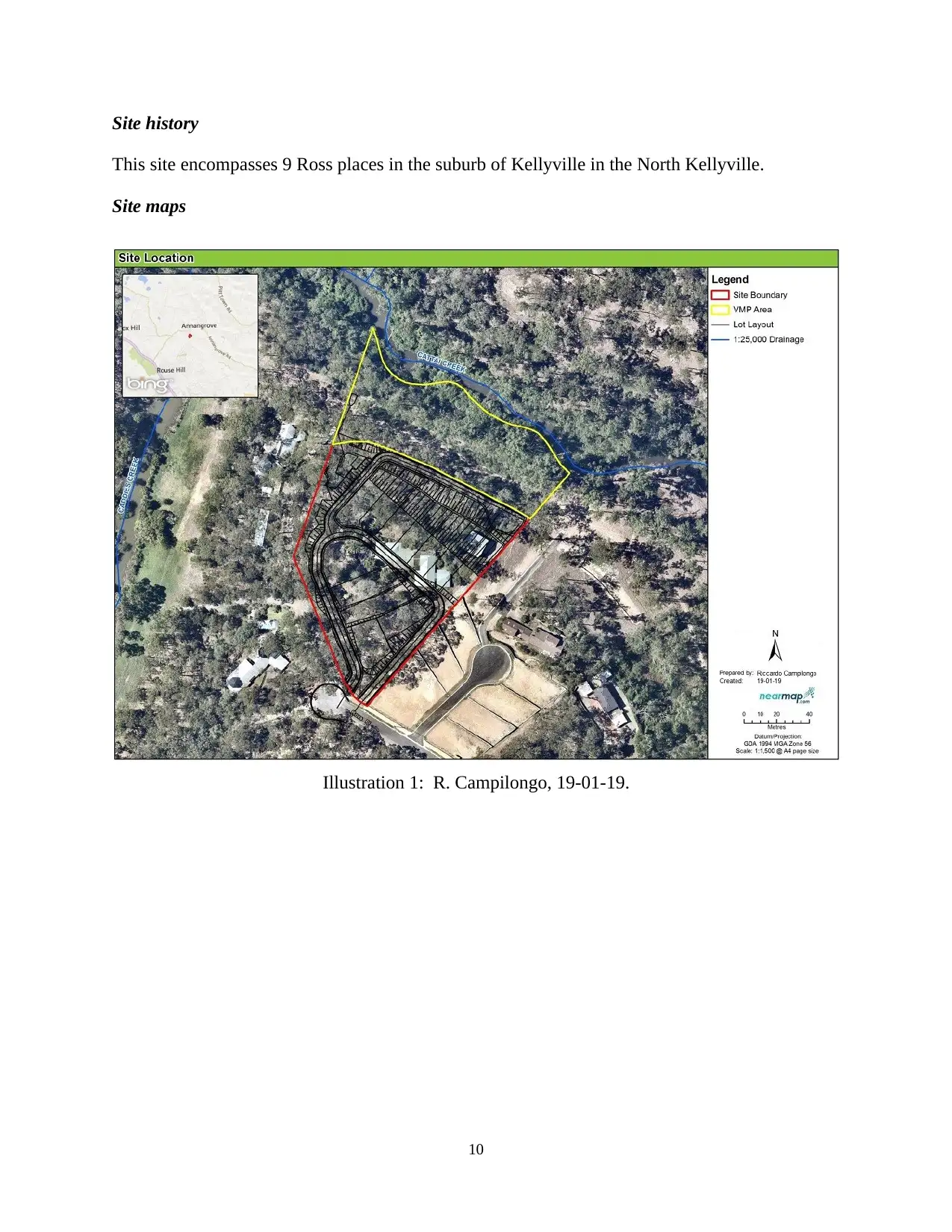
This site encompasses 9 Ross places in the suburb of Kellyville in the North Kellyville.
Site maps
10
Illustration 1: R. Campilongo, 19-01-19.
This site encompasses 9 Ross places in the suburb of Kellyville in the North Kellyville.
Site maps
10
Illustration 1: R. Campilongo, 19-01-19.
Paraphrase This Document
Need a fresh take? Get an instant paraphrase of this document with our AI Paraphraser
Google maps
11
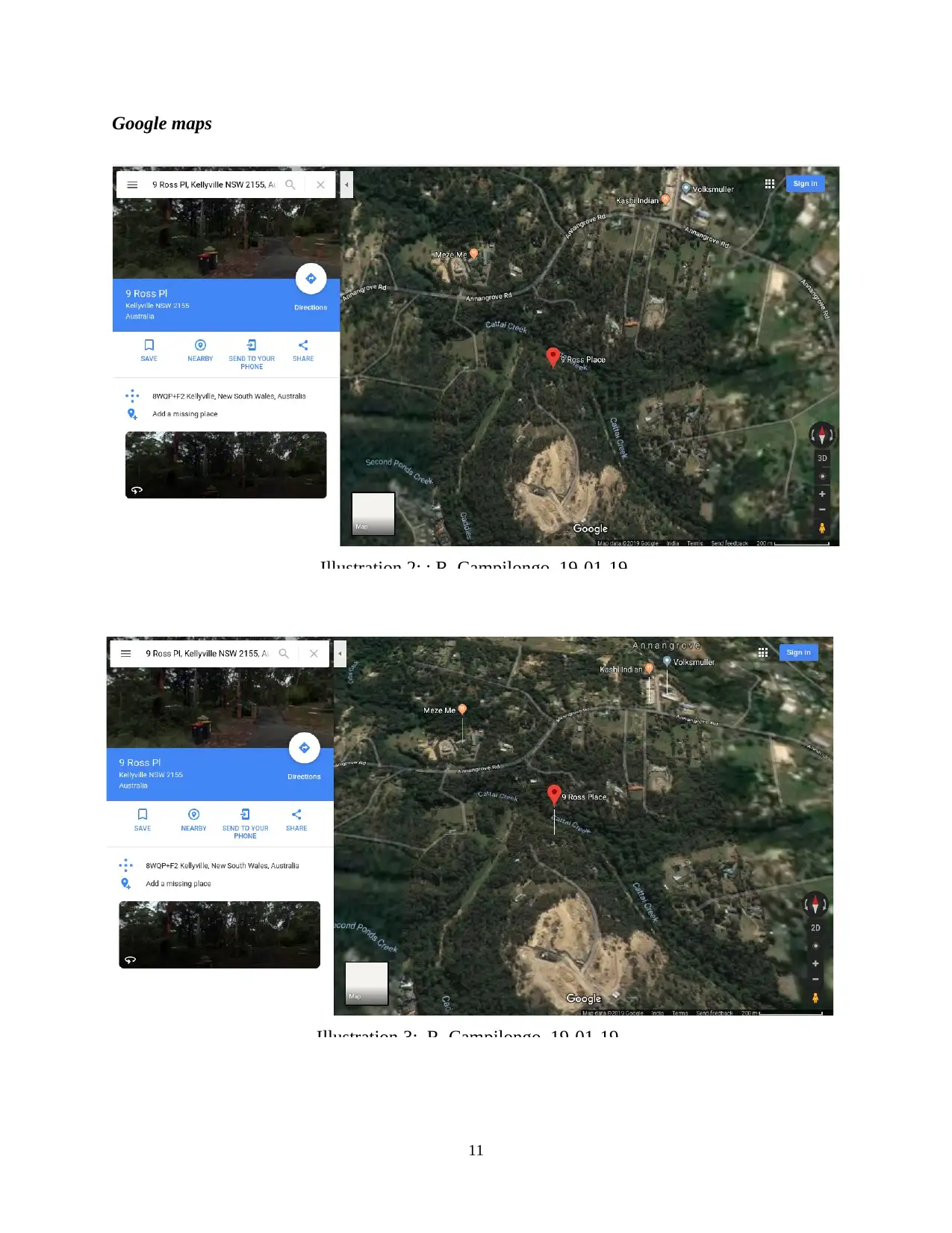
Illustration 2: : R. Campilongo, 19-01-19.
Illustration 3: R. Campilongo, 19-01-19.
11
Illustration 2: : R. Campilongo, 19-01-19.
Illustration 3: R. Campilongo, 19-01-19.
Topographical maps
12
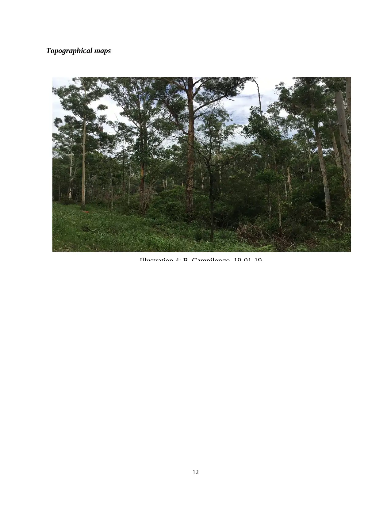
Illustration 4: R. Campilongo, 19-01-19.
12
Illustration 4: R. Campilongo, 19-01-19.
⊘ This is a preview!⊘
Do you want full access?
Subscribe today to unlock all pages.

Trusted by 1+ million students worldwide
1 out of 33
Your All-in-One AI-Powered Toolkit for Academic Success.
+13062052269
info@desklib.com
Available 24*7 on WhatsApp / Email
![[object Object]](/_next/static/media/star-bottom.7253800d.svg)
Unlock your academic potential
Copyright © 2020–2026 A2Z Services. All Rights Reserved. Developed and managed by ZUCOL.

