Scaled Physical Modeling of Inundated Roadways
Added on 2023-06-09
11 Pages2478 Words393 Views
Scaled Physical Modeling of Inundated Roadways 1
Research Proposal for Masters of Engineering (Civil)
On
Scaled Physical Modeling of Inundated Roadways
By Student’s Name
Course Name
Professor’s Name
University Name
City, State
Date
Research Proposal for Masters of Engineering (Civil)
On
Scaled Physical Modeling of Inundated Roadways
By Student’s Name
Course Name
Professor’s Name
University Name
City, State
Date
Scaled Physical Modeling of Inundated Roadways 2
Scaled Physical Modeling of Inundated Roadways
Objective
The overall objective of this project is to use the dimensional analysis techniques to design a
scaled physical model of a floodway that can be 3D printed and inserted into the flow channel at
the Causeway Bargara QLD 4670 (Hanslow 2018).
Introduction and Background
History of Causeway Bargara
It is a coastal town situated 13km in the north-east side of the Bundaberg. It is known to be the
largest coastal town within the region and Bargara forms the mouth of the makeable Burnet
River. Moreover, Bargara town formed the administrative seat and center of operation for the
former Burnett Shire management. Previously, the area was termed as sandhills and this was
due to the existence of the overall unstable sand formation in its coastal shores. This
happened in the decades of 1880s and formed the basis of land development in the area.
Li et al. (2018) noted that early land purchasers in the area found traces of sand drifts which
backed up in the houses incorporated with some marum planted grass back in the 1920s.
However, the existing land behind the parametric sandhills mainly denoted to in complete
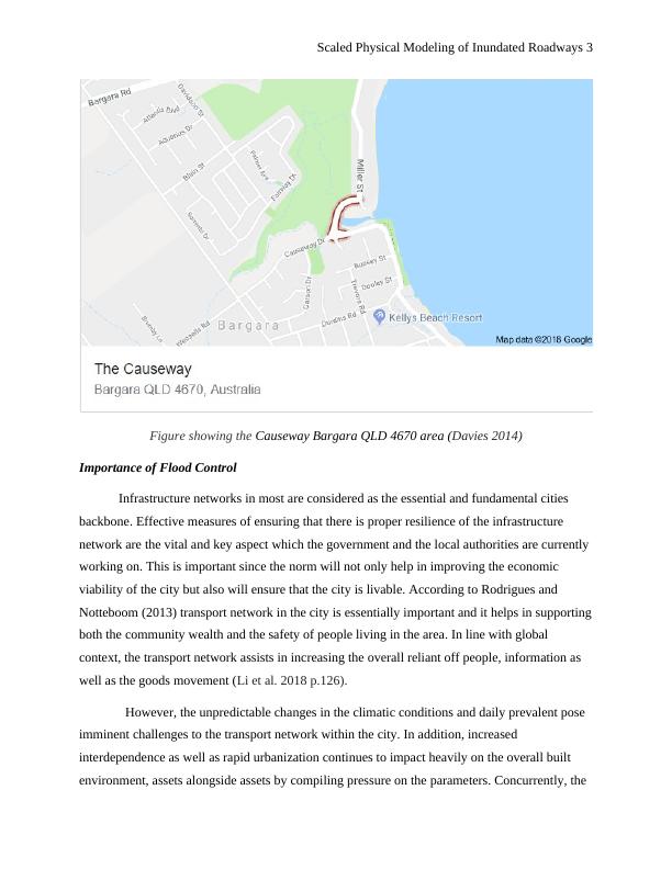
contrast. Thus, the area under appraisal mainly summarized indicated in the diagram below
Scaled Physical Modeling of Inundated Roadways
Objective
The overall objective of this project is to use the dimensional analysis techniques to design a
scaled physical model of a floodway that can be 3D printed and inserted into the flow channel at
the Causeway Bargara QLD 4670 (Hanslow 2018).
Introduction and Background
History of Causeway Bargara
It is a coastal town situated 13km in the north-east side of the Bundaberg. It is known to be the
largest coastal town within the region and Bargara forms the mouth of the makeable Burnet
River. Moreover, Bargara town formed the administrative seat and center of operation for the
former Burnett Shire management. Previously, the area was termed as sandhills and this was
due to the existence of the overall unstable sand formation in its coastal shores. This
happened in the decades of 1880s and formed the basis of land development in the area.
Li et al. (2018) noted that early land purchasers in the area found traces of sand drifts which
backed up in the houses incorporated with some marum planted grass back in the 1920s.
However, the existing land behind the parametric sandhills mainly denoted to in complete
contrast. Thus, the area under appraisal mainly summarized indicated in the diagram below
Scaled Physical Modeling of Inundated Roadways 3
Figure showing the Causeway Bargara QLD 4670 area (Davies 2014)
Importance of Flood Control
Infrastructure networks in most are considered as the essential and fundamental cities
backbone. Effective measures of ensuring that there is proper resilience of the infrastructure
network are the vital and key aspect which the government and the local authorities are currently
working on. This is important since the norm will not only help in improving the economic
viability of the city but also will ensure that the city is livable. According to Rodrigues and
Notteboom (2013) transport network in the city is essentially important and it helps in supporting
both the community wealth and the safety of people living in the area. In line with global
context, the transport network assists in increasing the overall reliant off people, information as
well as the goods movement (Li et al. 2018 p.126).
However, the unpredictable changes in the climatic conditions and daily prevalent pose
imminent challenges to the transport network within the city. In addition, increased
interdependence as well as rapid urbanization continues to impact heavily on the overall built
environment, assets alongside assets by compiling pressure on the parameters. Concurrently, the
Scaled Physical Modeling of Inundated Roadways 4
particularly evident is manifested in the makeable urban are whenever the transport system have
been subjected and affected by the imminent weather-related hazards such as floods. This
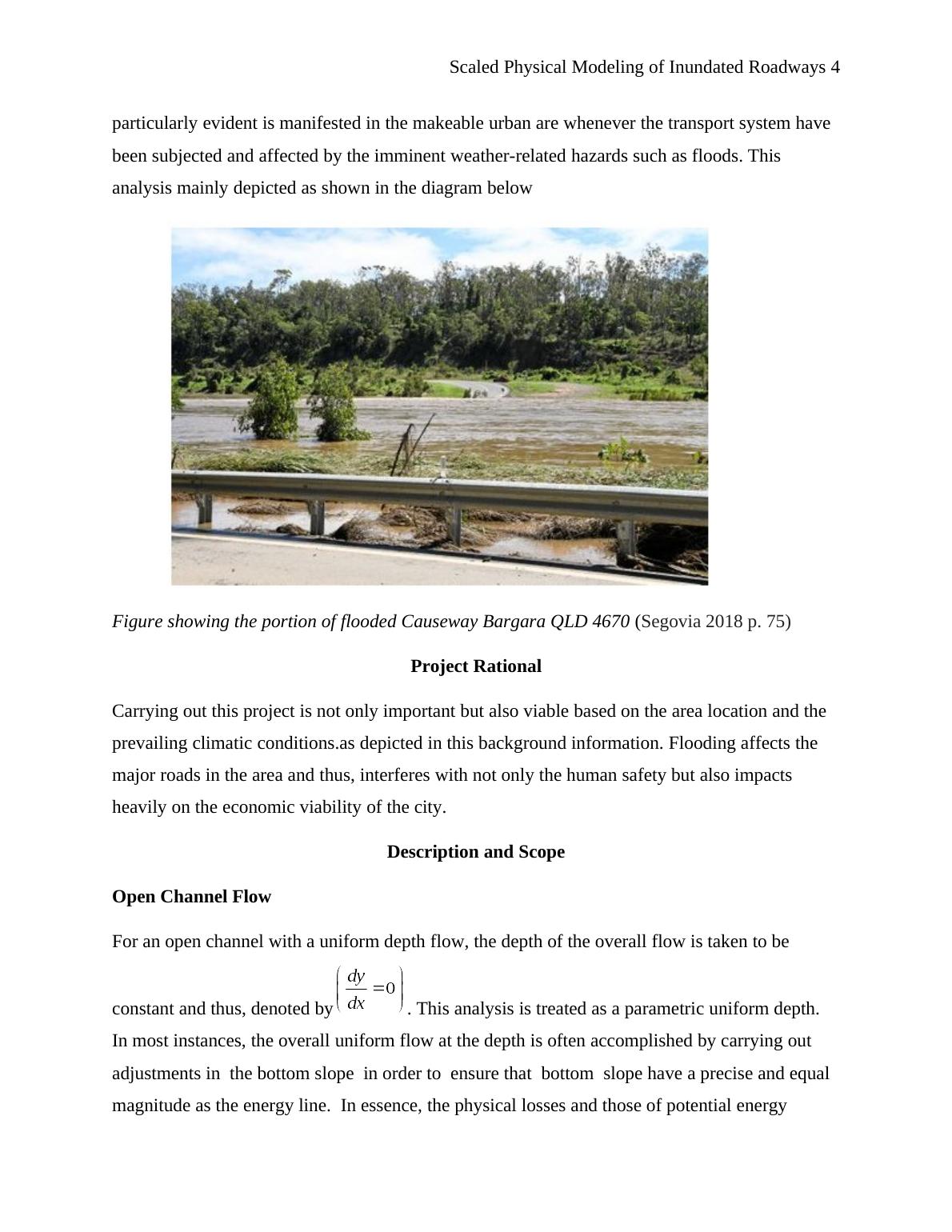
analysis mainly depicted as shown in the diagram below
Figure showing the portion of flooded Causeway Bargara QLD 4670 (Segovia 2018 p. 75)
Project Rational
Carrying out this project is not only important but also viable based on the area location and the
prevailing climatic conditions.as depicted in this background information. Flooding affects the
major roads in the area and thus, interferes with not only the human safety but also impacts
heavily on the economic viability of the city.
Description and Scope
Open Channel Flow
For an open channel with a uniform depth flow, the depth of the overall flow is taken to be
constant and thus, denoted by . This analysis is treated as a parametric uniform depth.
In most instances, the overall uniform flow at the depth is often accomplished by carrying out
adjustments in the bottom slope in order to ensure that bottom slope have a precise and equal
magnitude as the energy line. In essence, the physical losses and those of potential energy
particularly evident is manifested in the makeable urban are whenever the transport system have
been subjected and affected by the imminent weather-related hazards such as floods. This
analysis mainly depicted as shown in the diagram below
Figure showing the portion of flooded Causeway Bargara QLD 4670 (Segovia 2018 p. 75)
Project Rational
Carrying out this project is not only important but also viable based on the area location and the
prevailing climatic conditions.as depicted in this background information. Flooding affects the
major roads in the area and thus, interferes with not only the human safety but also impacts
heavily on the economic viability of the city.
Description and Scope
Open Channel Flow
For an open channel with a uniform depth flow, the depth of the overall flow is taken to be
constant and thus, denoted by . This analysis is treated as a parametric uniform depth.
In most instances, the overall uniform flow at the depth is often accomplished by carrying out
adjustments in the bottom slope in order to ensure that bottom slope have a precise and equal
magnitude as the energy line. In essence, the physical losses and those of potential energy
End of preview
Want to access all the pages? Upload your documents or become a member.
Related Documents
New Urbanism: A Development and Planning Tacticlg...
|10
|2755
|57