Seismic Analysis: Comparing Earthquake Events in Oceanic Regions
VerifiedAdded on 2023/04/25
|15
|2166
|498
Report
AI Summary
This report presents a seismic analysis comparing earthquake events in different oceanic settings, focusing on mid-oceanic ridges and deep-sea trenches. The analysis includes events on the Northern East Pacific Rise and the Central Mid-Atlantic Ridge, comparing their magnitudes, depths, and coordinates. Further investigation contrasts seismic activities near continental landmasses (Akutan, Alaska and Punta Cana, Dominican Republic) with those adjacent to islands (Northern Mariana Islands and Fiji), highlighting differences in depth and magnitude. The report concludes with a comparative evaluation of seismic activities in mid-oceanic ridges versus deep-sea trenches, emphasizing variations in depth, magnitude, and the tectonic processes involved. The document also references bathymetric maps and seismic activity related to fracture zones.
Running head: SEISMIC ANALYSIS
SEISMIC ANALYSIS
Name of the Student
Name of the University
Author Note
SEISMIC ANALYSIS
Name of the Student
Name of the University
Author Note
Paraphrase This Document
Need a fresh take? Get an instant paraphrase of this document with our AI Paraphraser
Response to Question no.1
The two events that are chosen for the case study include the Earthquake on the Northern
East Pacific Rise with on magnitude of 6.0 Richter on the Pacific Ocean. The other event
includes the earthquake on the Central Mid Atlantic Ridge with a magnitude of 5.2. The details
of these two events occurring on two different Ocean basins and on two different oceanic ridges
will give a better understanding of the seismic events.
M 6.0 - Northern East Pacific Rise
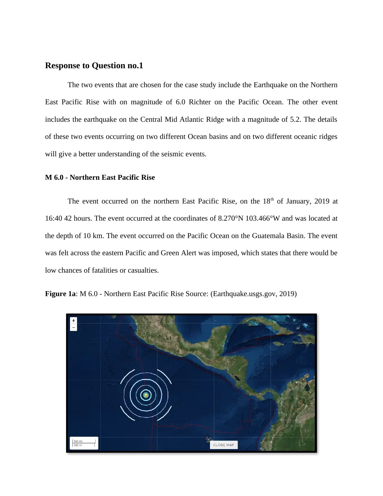
The event occurred on the northern East Pacific Rise, on the 18th of January, 2019 at
16:40 42 hours. The event occurred at the coordinates of 8.270°N 103.466°W and was located at
the depth of 10 km. The event occurred on the Pacific Ocean on the Guatemala Basin. The event
was felt across the eastern Pacific and Green Alert was imposed, which states that there would be
low chances of fatalities or casualties.
Figure 1a: M 6.0 - Northern East Pacific Rise Source: (Earthquake.usgs.gov, 2019)
The two events that are chosen for the case study include the Earthquake on the Northern
East Pacific Rise with on magnitude of 6.0 Richter on the Pacific Ocean. The other event
includes the earthquake on the Central Mid Atlantic Ridge with a magnitude of 5.2. The details
of these two events occurring on two different Ocean basins and on two different oceanic ridges
will give a better understanding of the seismic events.
M 6.0 - Northern East Pacific Rise
The event occurred on the northern East Pacific Rise, on the 18th of January, 2019 at
16:40 42 hours. The event occurred at the coordinates of 8.270°N 103.466°W and was located at
the depth of 10 km. The event occurred on the Pacific Ocean on the Guatemala Basin. The event
was felt across the eastern Pacific and Green Alert was imposed, which states that there would be
low chances of fatalities or casualties.
Figure 1a: M 6.0 - Northern East Pacific Rise Source: (Earthquake.usgs.gov, 2019)
M 5.2 - Central Mid-Atlantic Ridge
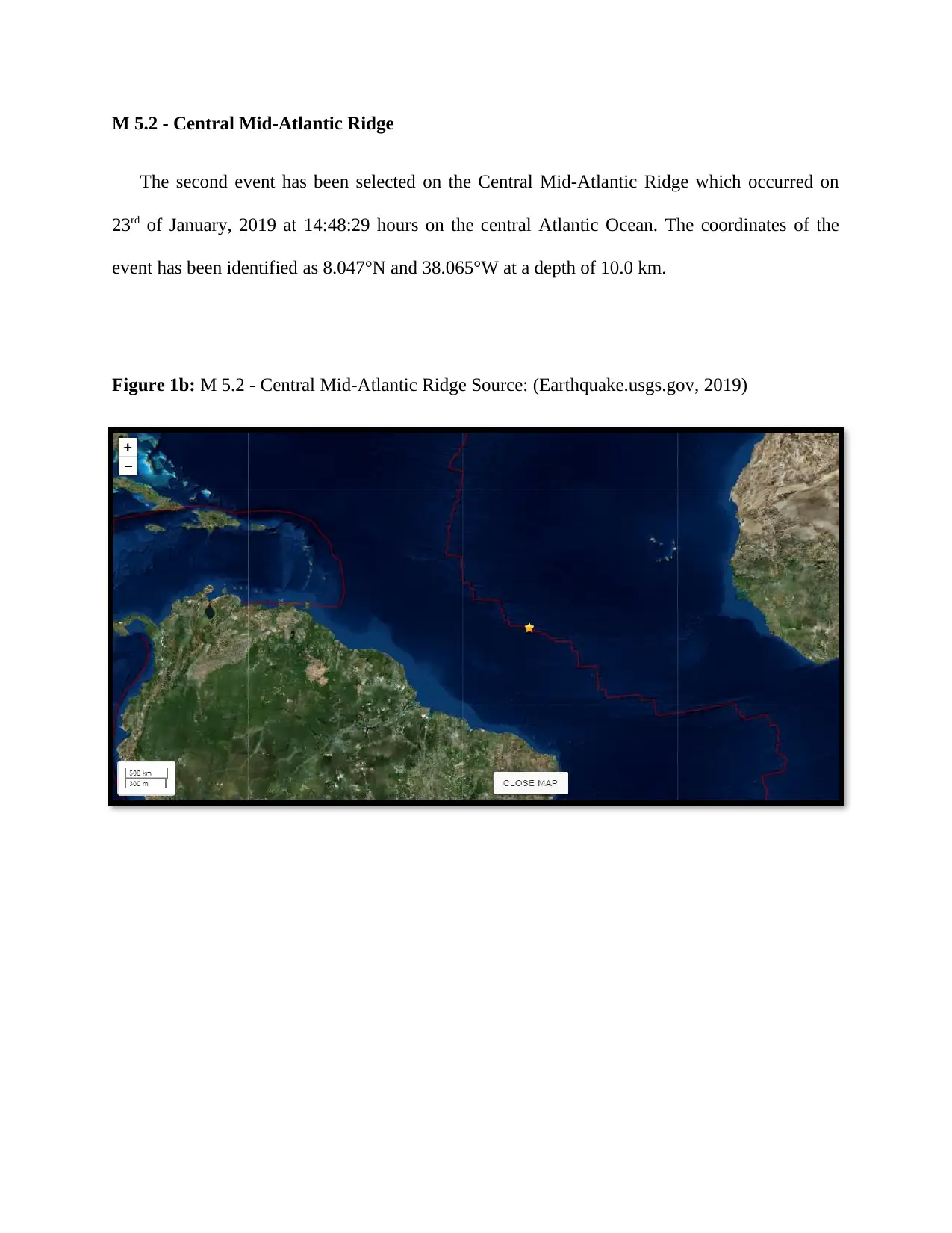
The second event has been selected on the Central Mid-Atlantic Ridge which occurred on
23rd of January, 2019 at 14:48:29 hours on the central Atlantic Ocean. The coordinates of the
event has been identified as 8.047°N and 38.065°W at a depth of 10.0 km.
Figure 1b: M 5.2 - Central Mid-Atlantic Ridge Source: (Earthquake.usgs.gov, 2019)
⊘ This is a preview!⊘
Do you want full access?
Subscribe today to unlock all pages.
Trusted by 1+ million students worldwide
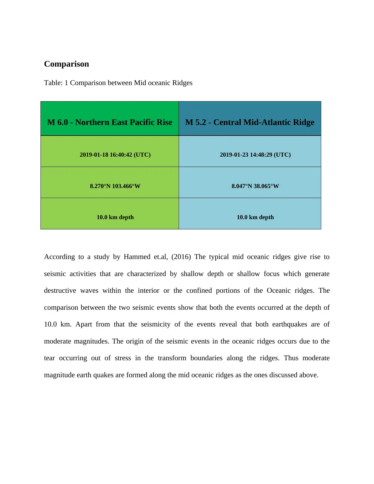
Comparison
Table: 1 Comparison between Mid oceanic Ridges
M 6.0 - Northern East Pacific Rise M 5.2 - Central Mid-Atlantic Ridge
2019-01-18 16:40:42 (UTC) 2019-01-23 14:48:29 (UTC)
8.270°N 103.466°W 8.047°N 38.065°W
10.0 km depth 10.0 km depth
According to a study by Hammed et.al, (2016) The typical mid oceanic ridges give rise to
seismic activities that are characterized by shallow depth or shallow focus which generate
destructive waves within the interior or the confined portions of the Oceanic ridges. The
comparison between the two seismic events show that both the events occurred at the depth of
10.0 km. Apart from that the seismicity of the events reveal that both earthquakes are of
moderate magnitudes. The origin of the seismic events in the oceanic ridges occurs due to the
tear occurring out of stress in the transform boundaries along the ridges. Thus moderate
magnitude earth quakes are formed along the mid oceanic ridges as the ones discussed above.
Paraphrase This Document
Need a fresh take? Get an instant paraphrase of this document with our AI Paraphraser
Response to question no. 2
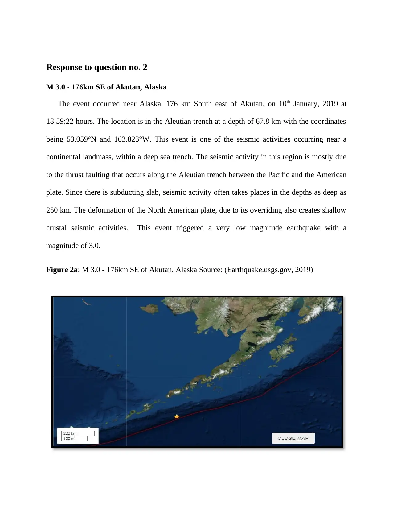
M 3.0 - 176km SE of Akutan, Alaska
The event occurred near Alaska, 176 km South east of Akutan, on 10th January, 2019 at
18:59:22 hours. The location is in the Aleutian trench at a depth of 67.8 km with the coordinates
being 53.059°N and 163.823°W. This event is one of the seismic activities occurring near a
continental landmass, within a deep sea trench. The seismic activity in this region is mostly due
to the thrust faulting that occurs along the Aleutian trench between the Pacific and the American
plate. Since there is subducting slab, seismic activity often takes places in the depths as deep as
250 km. The deformation of the North American plate, due to its overriding also creates shallow
crustal seismic activities. This event triggered a very low magnitude earthquake with a
magnitude of 3.0.
Figure 2a: M 3.0 - 176km SE of Akutan, Alaska Source: (Earthquake.usgs.gov, 2019)
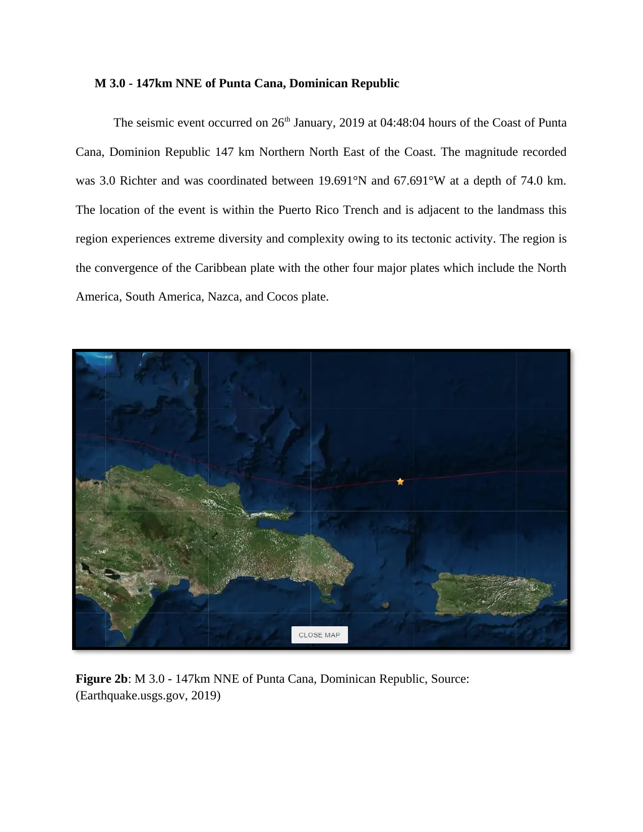
M 3.0 - 147km NNE of Punta Cana, Dominican Republic
The seismic event occurred on 26th January, 2019 at 04:48:04 hours of the Coast of Punta
Cana, Dominion Republic 147 km Northern North East of the Coast. The magnitude recorded
was 3.0 Richter and was coordinated between 19.691°N and 67.691°W at a depth of 74.0 km.
The location of the event is within the Puerto Rico Trench and is adjacent to the landmass this
region experiences extreme diversity and complexity owing to its tectonic activity. The region is
the convergence of the Caribbean plate with the other four major plates which include the North
America, South America, Nazca, and Cocos plate.
Figure 2b: M 3.0 - 147km NNE of Punta Cana, Dominican Republic, Source:
(Earthquake.usgs.gov, 2019)
⊘ This is a preview!⊘
Do you want full access?
Subscribe today to unlock all pages.
Trusted by 1+ million students worldwide
Comparison
Table 2: comparison between Deep Oceanic trenches adjacent to landmasses.
M 3.0 - 176km SE of Akutan,
Alaska
M 3.0 - 147km NNE of Punta Cana,
Dominican Republic
2019-01-10 18:59:22 (UTC) 2019-01-26 04:48:04 (UTC)
53.059°N 163.823°W 19.691°N 67.691°W
67.8 km depth 74.0 km depth
Table 2: comparison between Deep Oceanic trenches adjacent to landmasses.
M 3.0 - 176km SE of Akutan,
Alaska
M 3.0 - 147km NNE of Punta Cana,
Dominican Republic
2019-01-10 18:59:22 (UTC) 2019-01-26 04:48:04 (UTC)
53.059°N 163.823°W 19.691°N 67.691°W
67.8 km depth 74.0 km depth
Paraphrase This Document
Need a fresh take? Get an instant paraphrase of this document with our AI Paraphraser
Response to Question no.3
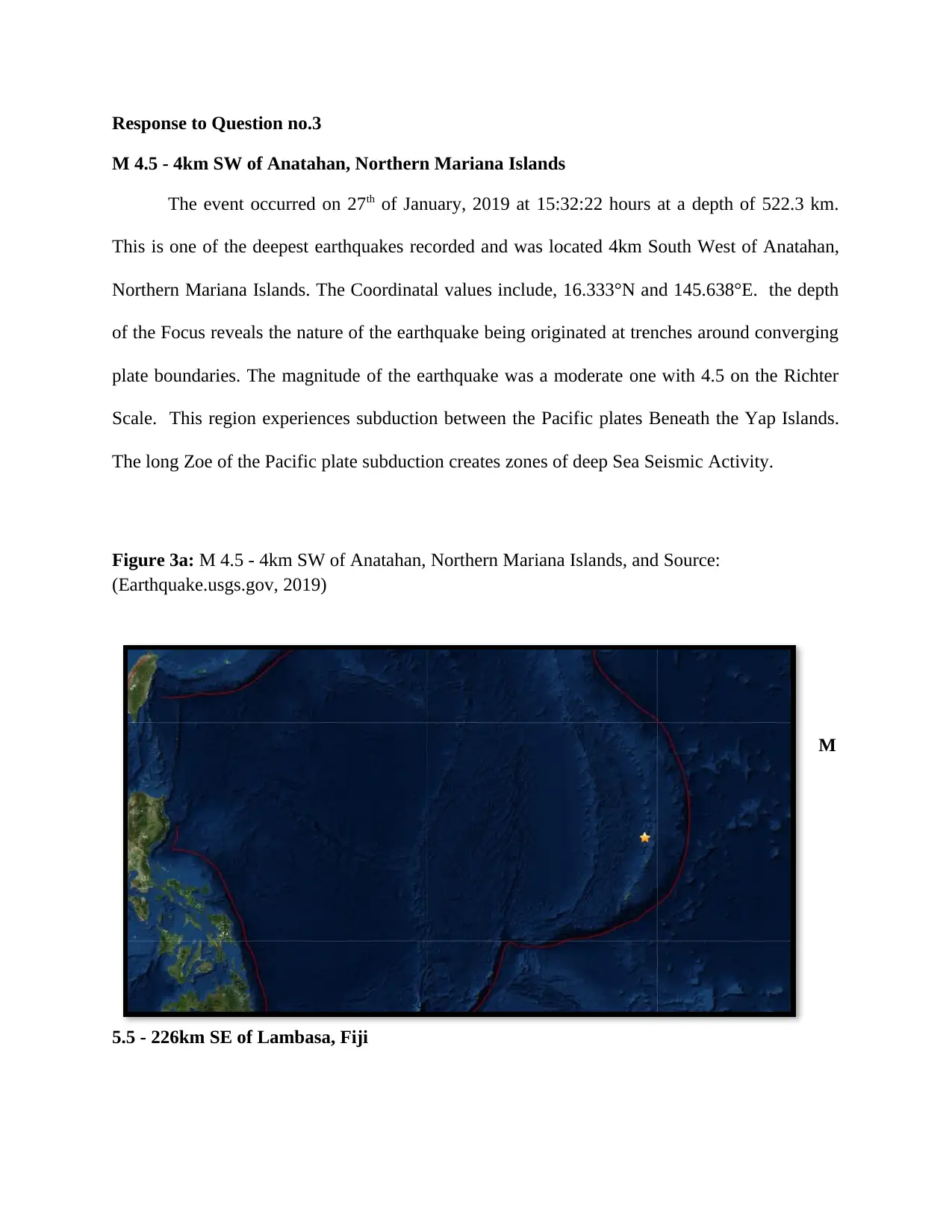
M 4.5 - 4km SW of Anatahan, Northern Mariana Islands
The event occurred on 27th of January, 2019 at 15:32:22 hours at a depth of 522.3 km.
This is one of the deepest earthquakes recorded and was located 4km South West of Anatahan,
Northern Mariana Islands. The Coordinatal values include, 16.333°N and 145.638°E. the depth
of the Focus reveals the nature of the earthquake being originated at trenches around converging
plate boundaries. The magnitude of the earthquake was a moderate one with 4.5 on the Richter
Scale. This region experiences subduction between the Pacific plates Beneath the Yap Islands.
The long Zoe of the Pacific plate subduction creates zones of deep Sea Seismic Activity.
Figure 3a: M 4.5 - 4km SW of Anatahan, Northern Mariana Islands, and Source:
(Earthquake.usgs.gov, 2019)
M
5.5 - 226km SE of Lambasa, Fiji
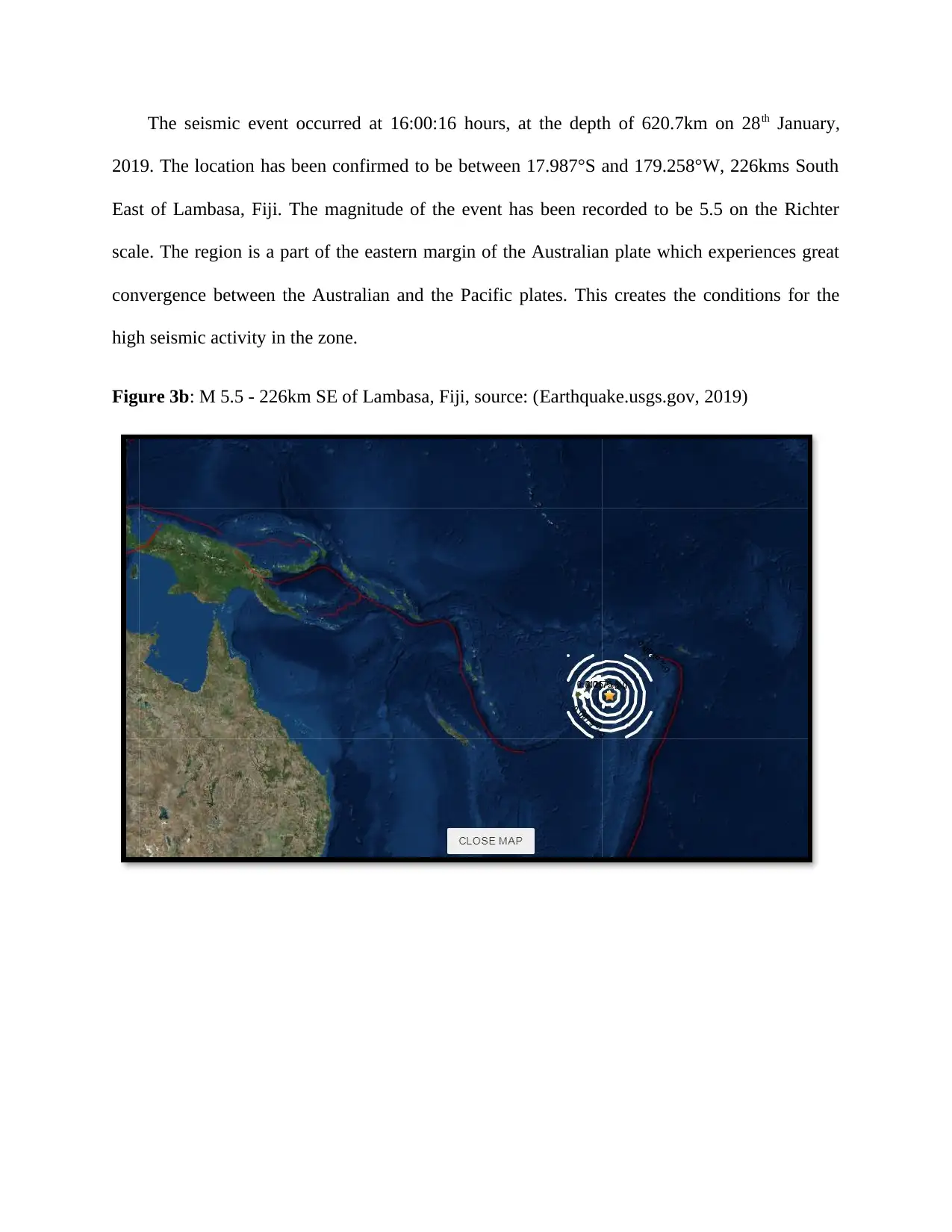
The seismic event occurred at 16:00:16 hours, at the depth of 620.7km on 28th January,
2019. The location has been confirmed to be between 17.987°S and 179.258°W, 226kms South
East of Lambasa, Fiji. The magnitude of the event has been recorded to be 5.5 on the Richter
scale. The region is a part of the eastern margin of the Australian plate which experiences great
convergence between the Australian and the Pacific plates. This creates the conditions for the
high seismic activity in the zone.
Figure 3b: M 5.5 - 226km SE of Lambasa, Fiji, source: (Earthquake.usgs.gov, 2019)
⊘ This is a preview!⊘
Do you want full access?
Subscribe today to unlock all pages.
Trusted by 1+ million students worldwide
Comparison
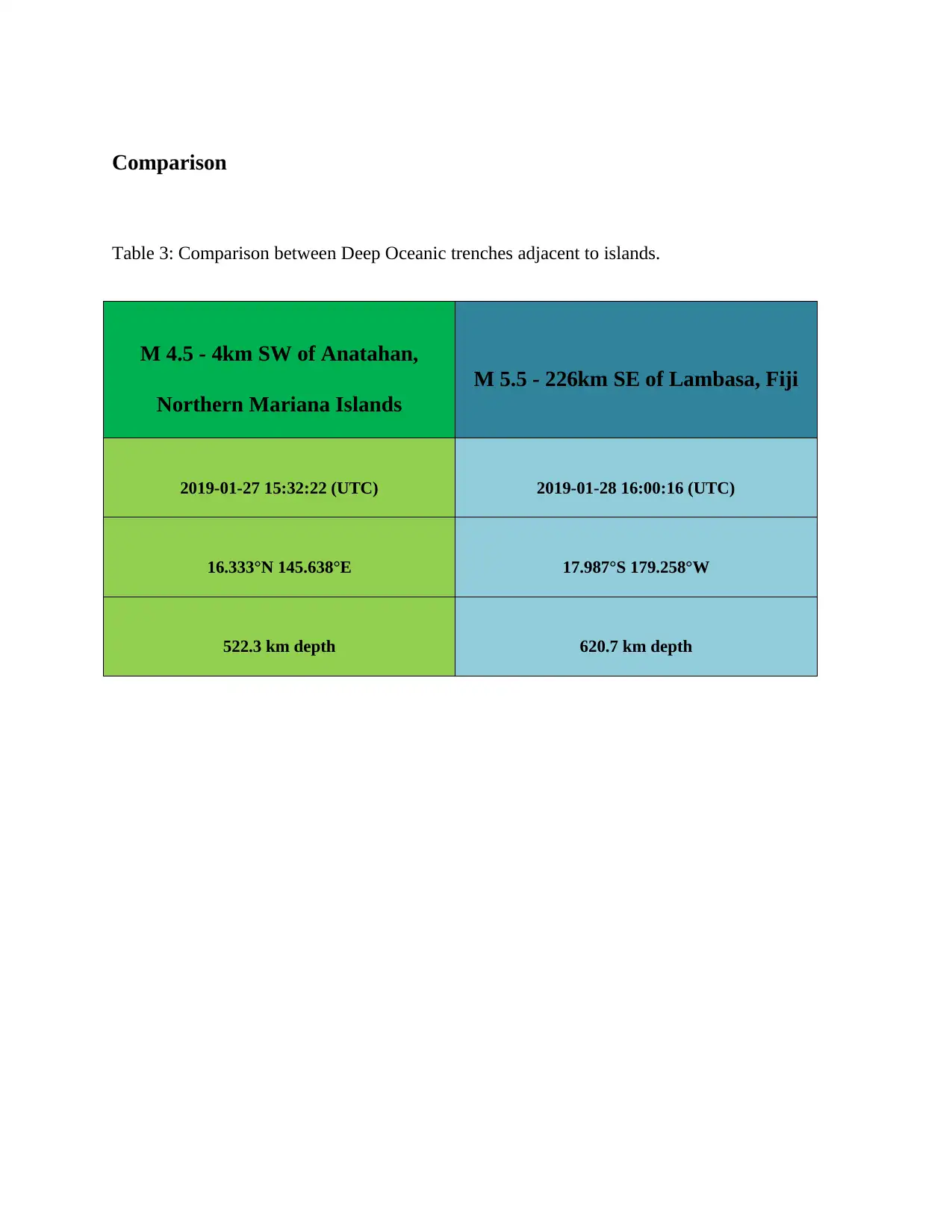
Table 3: Comparison between Deep Oceanic trenches adjacent to islands.
M 4.5 - 4km SW of Anatahan,
Northern Mariana Islands
M 5.5 - 226km SE of Lambasa, Fiji
2019-01-27 15:32:22 (UTC) 2019-01-28 16:00:16 (UTC)
16.333°N 145.638°E 17.987°S 179.258°W
522.3 km depth 620.7 km depth
Table 3: Comparison between Deep Oceanic trenches adjacent to islands.
M 4.5 - 4km SW of Anatahan,
Northern Mariana Islands
M 5.5 - 226km SE of Lambasa, Fiji
2019-01-27 15:32:22 (UTC) 2019-01-28 16:00:16 (UTC)
16.333°N 145.638°E 17.987°S 179.258°W
522.3 km depth 620.7 km depth
Paraphrase This Document
Need a fresh take? Get an instant paraphrase of this document with our AI Paraphraser
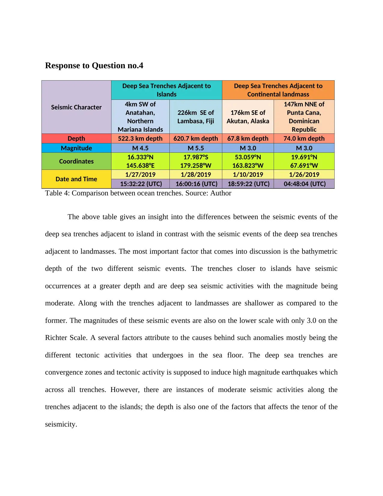
Response to Question no.4
Seismic Character
Deep Sea Trenches Adjacent to
Islands
Deep Sea Trenches Adjacent to
Continental landmass
4km SW of
Anatahan,
Northern
Mariana Islands
226km SE of
Lambasa, Fiji
176km SE of
Akutan, Alaska
147km NNE of
Punta Cana,
Dominican
Republic
Depth 522.3 km depth 620.7 km depth 67.8 km depth 74.0 km depth
Magnitude M 4.5 M 5.5 M 3.0 M 3.0
Coordinates 16.333°N
145.638°E
17.987°S
179.258°W
53.059°N
163.823°W
19.691°N
67.691°W
Date and Time 1/27/2019 1/28/2019 1/10/2019 1/26/2019
15:32:22 (UTC) 16:00:16 (UTC) 18:59:22 (UTC) 04:48:04 (UTC)
Table 4: Comparison between ocean trenches. Source: Author
The above table gives an insight into the differences between the seismic events of the
deep sea trenches adjacent to island in contrast with the seismic events of the deep sea trenches
adjacent to landmasses. The most important factor that comes into discussion is the bathymetric
depth of the two different seismic events. The trenches closer to islands have seismic
occurrences at a greater depth and are deep sea seismic activities with the magnitude being
moderate. Along with the trenches adjacent to landmasses are shallower as compared to the
former. The magnitudes of these seismic events are also on the lower scale with only 3.0 on the
Richter Scale. A several factors attribute to the causes behind such anomalies mostly being the
different tectonic activities that undergoes in the sea floor. The deep sea trenches are
convergence zones and tectonic activity is supposed to induce high magnitude earthquakes which
across all trenches. However, there are instances of moderate seismic activities along the
trenches adjacent to the islands; the depth is also one of the factors that affects the tenor of the
seismicity.
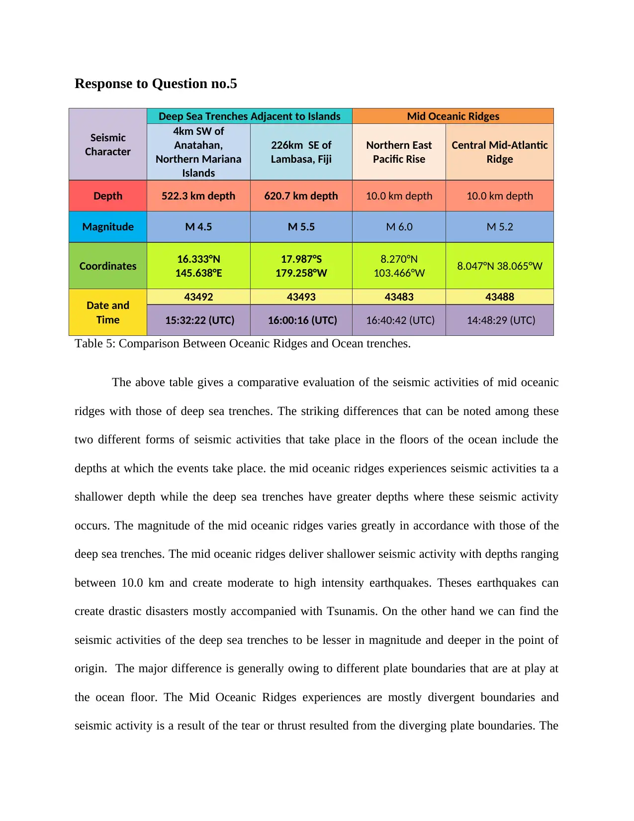
Response to Question no.5
Seismic
Character
Deep Sea Trenches Adjacent to Islands Mid Oceanic Ridges
4km SW of
Anatahan,
Northern Mariana
Islands
226km SE of
Lambasa, Fiji
Northern East
Pacific Rise
Central Mid-Atlantic
Ridge
Depth 522.3 km depth 620.7 km depth 10.0 km depth 10.0 km depth
Magnitude M 4.5 M 5.5 M 6.0 M 5.2
Coordinates 16.333°N
145.638°E
17.987°S
179.258°W
8.270°N
103.466°W 8.047°N 38.065°W
Date and
Time
43492 43493 43483 43488
15:32:22 (UTC) 16:00:16 (UTC) 16:40:42 (UTC) 14:48:29 (UTC)
Table 5: Comparison Between Oceanic Ridges and Ocean trenches.
The above table gives a comparative evaluation of the seismic activities of mid oceanic
ridges with those of deep sea trenches. The striking differences that can be noted among these
two different forms of seismic activities that take place in the floors of the ocean include the
depths at which the events take place. the mid oceanic ridges experiences seismic activities ta a
shallower depth while the deep sea trenches have greater depths where these seismic activity
occurs. The magnitude of the mid oceanic ridges varies greatly in accordance with those of the
deep sea trenches. The mid oceanic ridges deliver shallower seismic activity with depths ranging
between 10.0 km and create moderate to high intensity earthquakes. Theses earthquakes can
create drastic disasters mostly accompanied with Tsunamis. On the other hand we can find the
seismic activities of the deep sea trenches to be lesser in magnitude and deeper in the point of
origin. The major difference is generally owing to different plate boundaries that are at play at
the ocean floor. The Mid Oceanic Ridges experiences are mostly divergent boundaries and
seismic activity is a result of the tear or thrust resulted from the diverging plate boundaries. The
⊘ This is a preview!⊘
Do you want full access?
Subscribe today to unlock all pages.
Trusted by 1+ million students worldwide
1 out of 15
Your All-in-One AI-Powered Toolkit for Academic Success.
+13062052269
info@desklib.com
Available 24*7 on WhatsApp / Email
![[object Object]](/_next/static/media/star-bottom.7253800d.svg)
Unlock your academic potential
Copyright © 2020–2026 A2Z Services. All Rights Reserved. Developed and managed by ZUCOL.