Singapore City Sustainability Assessment: Environmental Project
VerifiedAdded on 2023/03/30
|17
|2925
|440
Project
AI Summary
This project provides a comprehensive sustainability assessment of Singapore City, examining its physical location, historical development, and current urban form. It delves into the city's transport arrangements, water use and management strategies, and its approach to integrating nature and supporting biodiversity. The project also assesses the impacts of climate change on the area and outlines a vision for the future, including plans for intelligent water management, land redevelopment, waste management, and biodiversity enhancements. The analysis incorporates various figures and diagrams to illustrate key concepts and data, offering a detailed overview of Singapore's sustainability initiatives and challenges. The project concludes with a discussion of the city's future goals, highlighting its commitment to becoming a liveable, sustainable, and vibrant urban center.
Running head: SINGAPORE CITY SUSTAINABILITY ASSESSMENT 1
Community Development on the Singapore City Sustainability Assessment
Student’s Name
Institutional Affiliation
Community Development on the Singapore City Sustainability Assessment
Student’s Name
Institutional Affiliation
Paraphrase This Document
Need a fresh take? Get an instant paraphrase of this document with our AI Paraphraser
SINGAPORE CITY SUSTAINABILITY ASSESSMENT 2
Table of Contents
1.0 Physical Location and Boundaries of Project Area................................................................................3
2.0 Rationale for Choosing Area.................................................................................................................4
3.0 An Analysis of the Area As It Presently Stands.....................................................................................4
History of the Area..................................................................................................................................4
An analysis of present transport arrangements........................................................................................5
An analysis of current urban form...........................................................................................................6
An analysis of the area’s water use and management..............................................................................7
An assessment of how well the area integrates nature and supports biodiversity....................................8
An assessment of impacts of climate change on the area.........................................................................9
4.0 Vision for the future of the area.....................................................................................................10
5.0 Plans for the Future........................................................................................................................10
Intelligent Water Management..............................................................................................................10
Land for Redevelopment.......................................................................................................................11
Waste Management...............................................................................................................................12
Biodiversity and Greening.....................................................................................................................12
Land-Use Integration.............................................................................................................................13
References.................................................................................................................................................15
SINGAPORE CITY SUSTAINABILITY ASSESSMENT 3
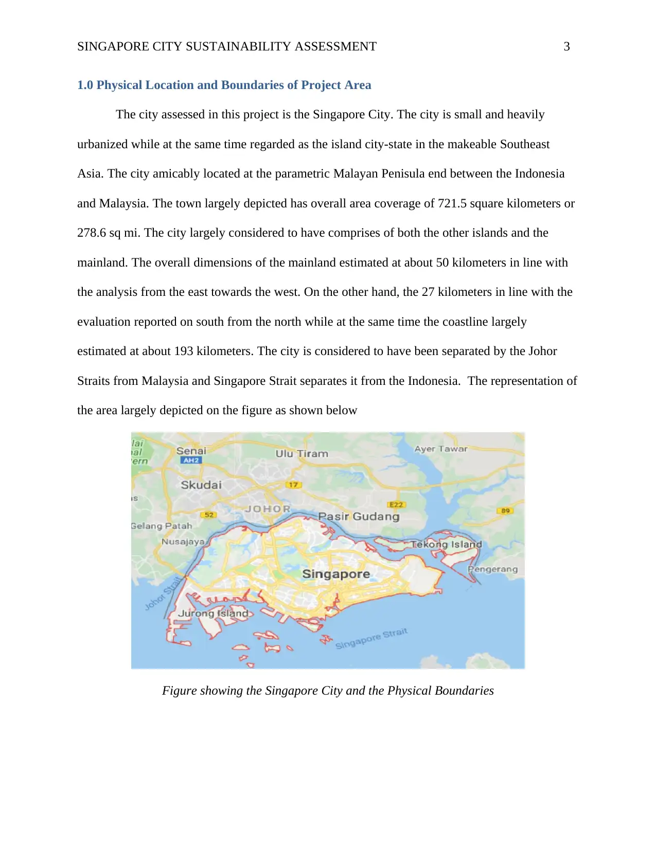
1.0 Physical Location and Boundaries of Project Area
The city assessed in this project is the Singapore City. The city is small and heavily
urbanized while at the same time regarded as the island city-state in the makeable Southeast
Asia. The city amicably located at the parametric Malayan Penisula end between the Indonesia
and Malaysia. The town largely depicted has overall area coverage of 721.5 square kilometers or
278.6 sq mi. The city largely considered to have comprises of both the other islands and the
mainland. The overall dimensions of the mainland estimated at about 50 kilometers in line with
the analysis from the east towards the west. On the other hand, the 27 kilometers in line with the
evaluation reported on south from the north while at the same time the coastline largely
estimated at about 193 kilometers. The city is considered to have been separated by the Johor
Straits from Malaysia and Singapore Strait separates it from the Indonesia. The representation of
the area largely depicted on the figure as shown below
Figure showing the Singapore City and the Physical Boundaries
⊘ This is a preview!⊘
Do you want full access?
Subscribe today to unlock all pages.
Trusted by 1+ million students worldwide
SINGAPORE CITY SUSTAINABILITY ASSESSMENT 4
2.0 Rationale for Choosing Area
The rational for choosing the area is largely depicted on a number of different reasons.
One of the reasons is that the sustainable plan and the assessment studies which the country has
put into consideration are worth appraising and analyzing as far as the study is concerned. For
instance, the country has developed the blue print grounded on the rising population and
intensified and rapid urbanization in the area. This has pose challenges on both the infrastructure
as well as climate as a whole.
3.0 An Analysis of the Area As It Presently Stands
History of the Area
Asher & Bali (2013) the history regarding the City of Singapore largely dated to the
overall third century. The available literatures indicated that the area had a significant trading
settlement which is believed to have existed from 14th century. Singapore largely regarded as a
parametric island city-state with a are size of 685km2. Besides, it has a population of at least
5.6 million. Also, it is important to deduce that the city was under the rule of the makeable
Parameswara during the late 14 the century. It is believed that Parameswara to gain the reign
after killing the previous ruler but later on the individual was expelled by the overall Siamese or
Majapahit. Later on the city was governed by the Johor Sultanate and Malacca Sultanate.
Preferably, it is believed that there was the negotiation and the agreement which led to
the signing of the treaty in 1819. The treaty enables the Johor to reach the agreement with the
British and this led to the establishment of the trading port on the makeable island. Also, it is
evidential that the treaty also contributed to the initiation of the British colony of the overall
Singapore in the same year. Moreover, it is believed that Japanese empire often conquered the
state during the Second World War and the duration largely disseminated between 1942 and
Paraphrase This Document
Need a fresh take? Get an instant paraphrase of this document with our AI Paraphraser
SINGAPORE CITY SUSTAINABILITY ASSESSMENT 5
1945. However, the city is considered to have reverted to the British colony after the end of the
war. Conversely, there was the claiming of the self-governance and this was granted when the
city merged with the Malaya Federation to form the Malaysia state in 1963 (Goldstein et al.,
2013).
Nevertheless, there was increased disputes and social unrest which accelerated between
the Party and Malaysia's Alliance Party and Singapore's ruling People's Action. This led to the
expulsion of Singapore from Malaysia and thus, the state gaining it independence on the
makeable 9th August 1965 (Artmann, & Sartison, 2018). The country faced a number of
problems regarding the housing crisis and unemployment. Thus, the country embarked on the
process of modernization pragma. This begun in 1960 was depicted through the 1970s and
thereby, leading to the establishment of the manufacturing industry in the area. Thus, the state
was able to develop both the public education and the public housing estates. Moreover, in
1990s, the country reported a growth and became one of the most prosperous world states and
cities. This growth was deluded to the highly modernized market economy with both the highest
per capita gross as well as strong links established in line with the international trades (Sharifi &
Murayama 2013).
An analysis of present transport arrangements
Preferably, the primary and most used transportation mode in the country is largely
grounded on the land-based. In essence, most of the sections and parts of the Singapore city
largely accessed via the use of the roads and these include Junrong Island and Sentosa. The other
transport systems used in the country include the rail which is considered as either Mass Rapid or
the Light Rail Transit. The Mass Rapid Transit refers to the ones which are considered in line
with the width and lengths whereas the Light Rail Transit often considered as those cutting
SINGAPORE CITY SUSTAINABILITY ASSESSMENT 6
across the different neighborhood. Considerably, the Singapore Main Island is often connected to
the amicable other islands via the application of the ferryboat services. Also, there two key
bridges which links the state to the Malaysia. They are defined as Causeway as well as Second
Link. On the other hand, the major aviation hub in the area is denoted as the Singapore Changi
Airport.
Alternatively, the city largely considered to have one of the major ports in line with the
transshipment norm. Also, the overall distribution of the transport system in the country largely
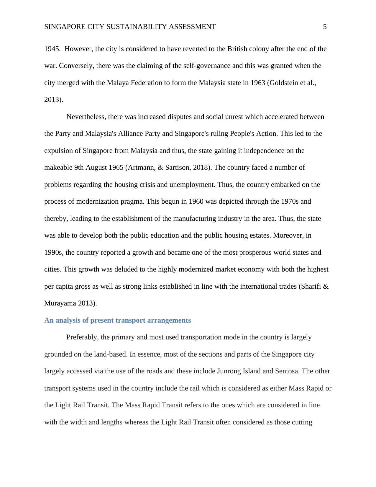
depicted as follows (Caprotti, Springer, & Harmer, 2015).
Figures Showing the Distribution of the Vehicles in City (Zhao et al., 2018)
From the analysis above, it is evidential that there is rapid growth in the number of cars per year
as far as the evaluation for both the private and other vehicles are concerned.
An analysis of current urban form
There are different forms of current urban forms which one can considered when
assessing the Singapore city. These include land use, housing types and population densities. The
population of the Singapore city is estimated at about 5.08 million with the resident population
approximated at about 3.77 million. The public housing is considered as essential in the area
with 900,000 disseminated HDB flats which are under management.
In essence, it is important to note that the population of the Singapore residents living the
in the sophisticated public housing is approximated at 82%. Alternatively, the 90% of the
individuals residing in the public housing are depicted be in the households which are classified
across the different neighborhood. Considerably, the Singapore Main Island is often connected to
the amicable other islands via the application of the ferryboat services. Also, there two key
bridges which links the state to the Malaysia. They are defined as Causeway as well as Second
Link. On the other hand, the major aviation hub in the area is denoted as the Singapore Changi
Airport.
Alternatively, the city largely considered to have one of the major ports in line with the
transshipment norm. Also, the overall distribution of the transport system in the country largely
depicted as follows (Caprotti, Springer, & Harmer, 2015).
Figures Showing the Distribution of the Vehicles in City (Zhao et al., 2018)
From the analysis above, it is evidential that there is rapid growth in the number of cars per year
as far as the evaluation for both the private and other vehicles are concerned.
An analysis of current urban form
There are different forms of current urban forms which one can considered when
assessing the Singapore city. These include land use, housing types and population densities. The
population of the Singapore city is estimated at about 5.08 million with the resident population
approximated at about 3.77 million. The public housing is considered as essential in the area
with 900,000 disseminated HDB flats which are under management.
In essence, it is important to note that the population of the Singapore residents living the
in the sophisticated public housing is approximated at 82%. Alternatively, the 90% of the
individuals residing in the public housing are depicted be in the households which are classified
⊘ This is a preview!⊘
Do you want full access?
Subscribe today to unlock all pages.
Trusted by 1+ million students worldwide
SINGAPORE CITY SUSTAINABILITY ASSESSMENT 7
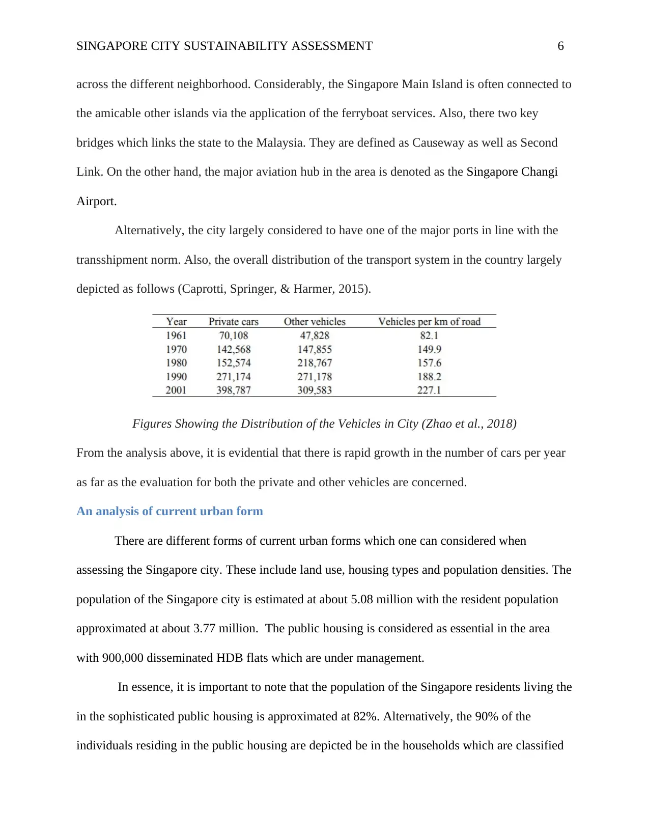
under the home ownership flats. The development of the housing in the city largely depicted as
illustrated in the figure below
Figure Showing the Housing Development in the Area (Wang et al., 2013)
An analysis of the area’s water use and management
There is a high and increased demand for the water use in Singapore City. The water
usage in the city largely divided into non-domestic and domestic. The overall consumption
value for the water in area mainly estimated at about 430 million gallons per day also
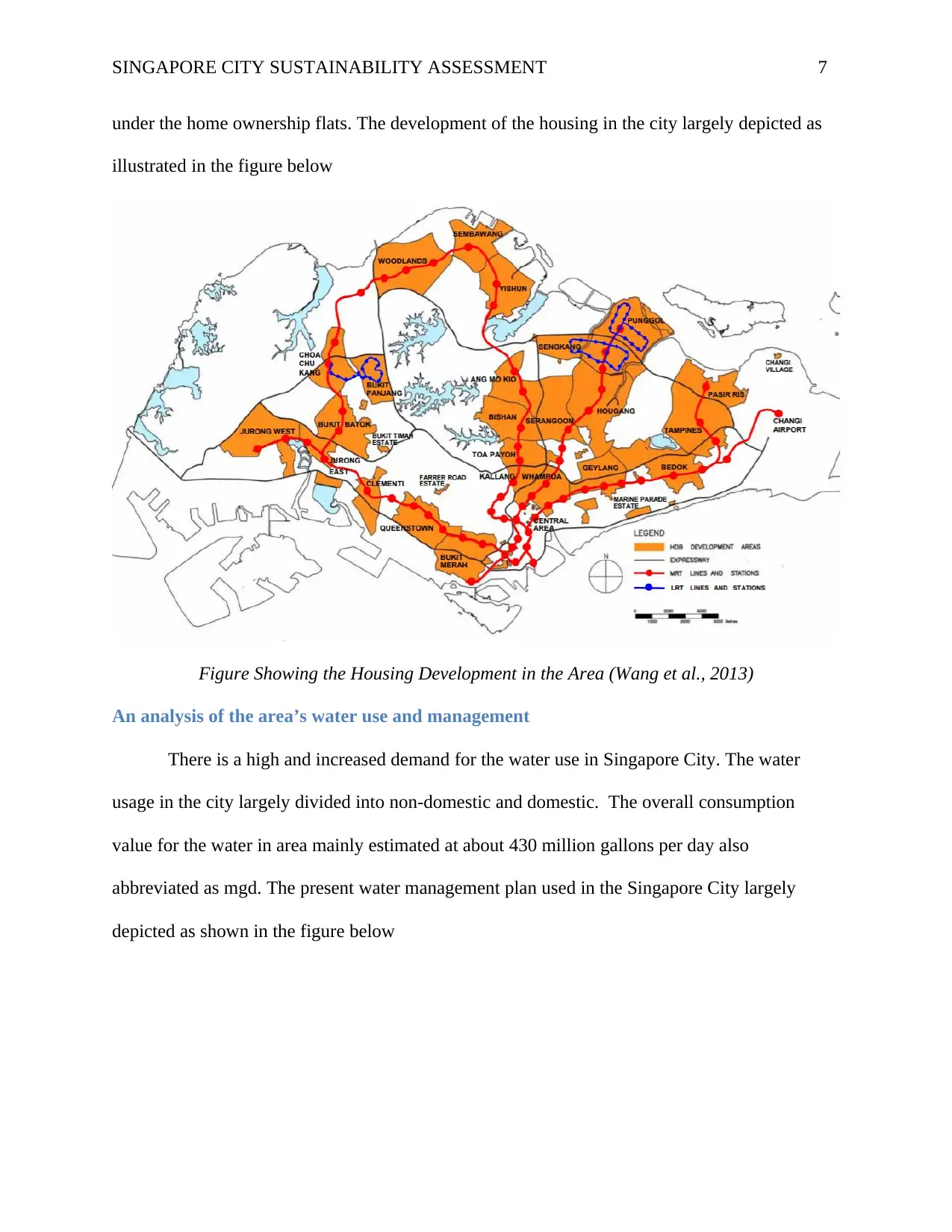
abbreviated as mgd. The present water management plan used in the Singapore City largely
depicted as shown in the figure below
under the home ownership flats. The development of the housing in the city largely depicted as
illustrated in the figure below
Figure Showing the Housing Development in the Area (Wang et al., 2013)
An analysis of the area’s water use and management
There is a high and increased demand for the water use in Singapore City. The water
usage in the city largely divided into non-domestic and domestic. The overall consumption
value for the water in area mainly estimated at about 430 million gallons per day also
abbreviated as mgd. The present water management plan used in the Singapore City largely
depicted as shown in the figure below
Paraphrase This Document
Need a fresh take? Get an instant paraphrase of this document with our AI Paraphraser
SINGAPORE CITY SUSTAINABILITY ASSESSMENT 8
Figure showing the Water Management Concept in Singapore (Hsu et al., 2013)
The analogy regarding the concept mainly divided into three key and essential strategies and
these include
Collect of the rain water
Reuse water
Desalinate seawater
An assessment of how well the area integrates nature and supports biodiversity
The geographical location of the Singapore City as well as its overall tropical climate
enables it to support different lush and natural vegetation. The city is however considered to have
lost at 90% of its overall forest cover. The norm is considered as home of huge plants and
animals in line with diversity. The city has at 1400 different species of native and vascular
plants. It also has 376 birds and 282 butterfly species. Conversely, there are 102 reptiles, 58
mammals as well as 27 amphibians. On the other hand, one can deduce that the number of the
SINGAPORE CITY SUSTAINABILITY ASSESSMENT 9
hard corals is 200 species, reef fish are 111 whereas sea grasses depicted at 11 as per the norms
of the marine environment (Li et al., 2019).
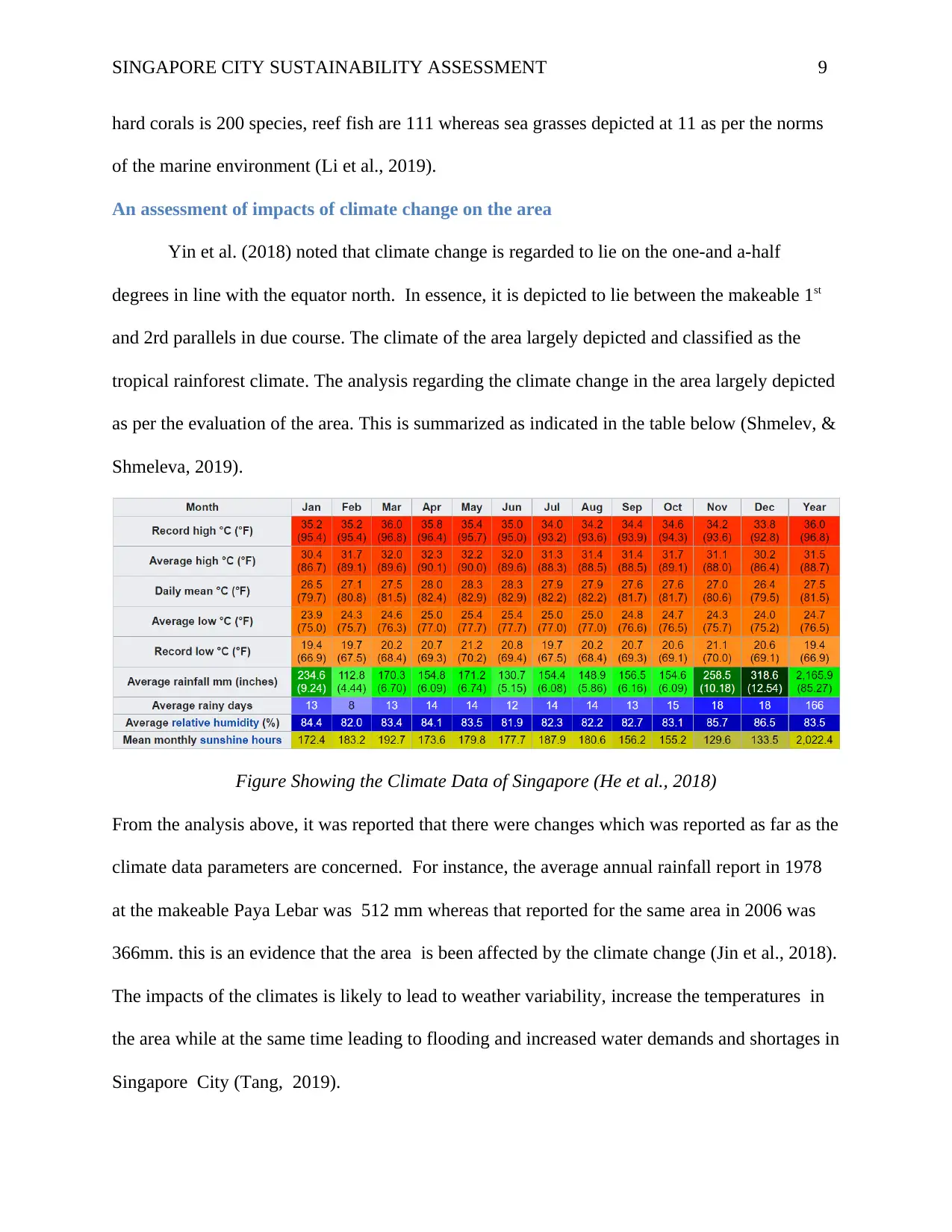
An assessment of impacts of climate change on the area
Yin et al. (2018) noted that climate change is regarded to lie on the one-and a-half
degrees in line with the equator north. In essence, it is depicted to lie between the makeable 1st
and 2rd parallels in due course. The climate of the area largely depicted and classified as the
tropical rainforest climate. The analysis regarding the climate change in the area largely depicted
as per the evaluation of the area. This is summarized as indicated in the table below (Shmelev, &
Shmeleva, 2019).
Figure Showing the Climate Data of Singapore (He et al., 2018)
From the analysis above, it was reported that there were changes which was reported as far as the
climate data parameters are concerned. For instance, the average annual rainfall report in 1978
at the makeable Paya Lebar was 512 mm whereas that reported for the same area in 2006 was
366mm. this is an evidence that the area is been affected by the climate change (Jin et al., 2018).
The impacts of the climates is likely to lead to weather variability, increase the temperatures in
the area while at the same time leading to flooding and increased water demands and shortages in
Singapore City (Tang, 2019).
hard corals is 200 species, reef fish are 111 whereas sea grasses depicted at 11 as per the norms
of the marine environment (Li et al., 2019).
An assessment of impacts of climate change on the area
Yin et al. (2018) noted that climate change is regarded to lie on the one-and a-half
degrees in line with the equator north. In essence, it is depicted to lie between the makeable 1st
and 2rd parallels in due course. The climate of the area largely depicted and classified as the
tropical rainforest climate. The analysis regarding the climate change in the area largely depicted
as per the evaluation of the area. This is summarized as indicated in the table below (Shmelev, &
Shmeleva, 2019).
Figure Showing the Climate Data of Singapore (He et al., 2018)
From the analysis above, it was reported that there were changes which was reported as far as the
climate data parameters are concerned. For instance, the average annual rainfall report in 1978
at the makeable Paya Lebar was 512 mm whereas that reported for the same area in 2006 was
366mm. this is an evidence that the area is been affected by the climate change (Jin et al., 2018).
The impacts of the climates is likely to lead to weather variability, increase the temperatures in
the area while at the same time leading to flooding and increased water demands and shortages in
Singapore City (Tang, 2019).
⊘ This is a preview!⊘
Do you want full access?
Subscribe today to unlock all pages.
Trusted by 1+ million students worldwide
SINGAPORE CITY SUSTAINABILITY ASSESSMENT 10
4.0 Vision for the future of the area
There are different visions which one can depict for the Singapore Area as per the
analysis. They include
To ensure that the Singapore city has a Liveable as well as Endearing Home
To have a decisive Sustainable and Vibrant City
To have an overall Gracious and Active Community
5.0 Plans for the Future
The section largely discussed in various sub-sections as follows
Intelligent Water Management
There are different factors which have pilled pressure on the water usage in the area.
They include rising water demands, increasing operational costs, constraints in manpower as
well as the new challenges such as the climate change. In essence, the city is adopting the PUB
technology enables it to offer both the smart technologies as well as leverage regarding the
digital solution. This aims at strengthening its overall operational resilience, safety, productivity
as well as security. The application of the integration Smart water know-how aims at providing a
key pillar in line with the water resource management in Singapore to help in achieving the
greater efficiencies in the long run. Further to this, the system also aims at helping in giving
faster response as far as the time planning, service and operation delivery is concerned. The
Paraphrase This Document
Need a fresh take? Get an instant paraphrase of this document with our AI Paraphraser
SINGAPORE CITY SUSTAINABILITY ASSESSMENT 11
concept the regarding the approach mainly summarized as follows (Liu, 2018).
Schematic Diagram showing the Smart Pub Roadmap (Deng, Peng, & Tang, 2019)
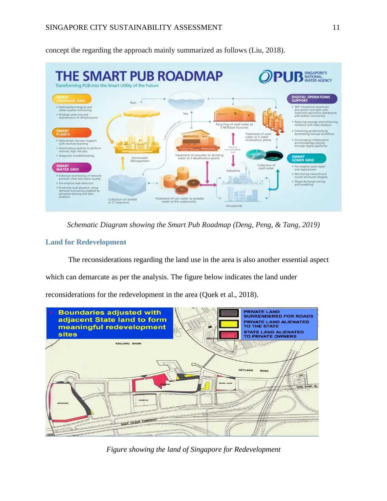
Land for Redevelopment
The reconsiderations regarding the land use in the area is also another essential aspect
which can demarcate as per the analysis. The figure below indicates the land under
reconsiderations for the redevelopment in the area (Quek et al., 2018).
Figure showing the land of Singapore for Redevelopment
concept the regarding the approach mainly summarized as follows (Liu, 2018).
Schematic Diagram showing the Smart Pub Roadmap (Deng, Peng, & Tang, 2019)
Land for Redevelopment
The reconsiderations regarding the land use in the area is also another essential aspect
which can demarcate as per the analysis. The figure below indicates the land under
reconsiderations for the redevelopment in the area (Quek et al., 2018).
Figure showing the land of Singapore for Redevelopment
SINGAPORE CITY SUSTAINABILITY ASSESSMENT 12
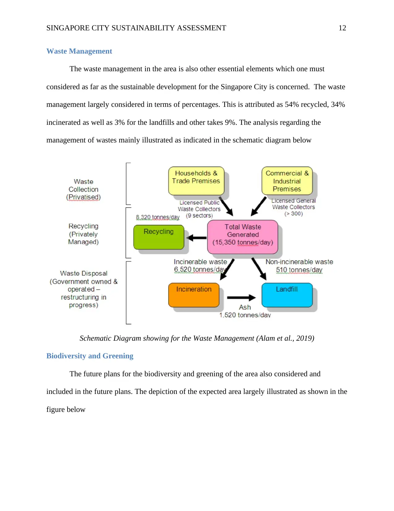
Waste Management
The waste management in the area is also other essential elements which one must
considered as far as the sustainable development for the Singapore City is concerned. The waste
management largely considered in terms of percentages. This is attributed as 54% recycled, 34%
incinerated as well as 3% for the landfills and other takes 9%. The analysis regarding the
management of wastes mainly illustrated as indicated in the schematic diagram below
Schematic Diagram showing for the Waste Management (Alam et al., 2019)
Biodiversity and Greening
The future plans for the biodiversity and greening of the area also considered and
included in the future plans. The depiction of the expected area largely illustrated as shown in the
figure below
⊘ This is a preview!⊘
Do you want full access?
Subscribe today to unlock all pages.
Trusted by 1+ million students worldwide
1 out of 17


Your All-in-One AI-Powered Toolkit for Academic Success.
+13062052269
info@desklib.com
Available 24*7 on WhatsApp / Email
![[object Object]](/_next/static/media/star-bottom.7253800d.svg)
Unlock your academic potential
Copyright © 2020–2026 A2Z Services. All Rights Reserved. Developed and managed by ZUCOL.