Spatial Data Supply Chain Provenance Modelling using Semantic Web Technologies
VerifiedAdded on 2022/10/12
|36
|9431
|115
AI Summary
This dissertation discusses the use of W3C provenance for addressing geospatial data provenance at different levels. It also highlights the importance of geospatial data provenance in GIS applications and the need for a geospatial provenance model that captures the processes involved in the spatial data supply chains.
Contribute Materials
Your contribution can guide someone’s learning journey. Share your
documents today.
Spatial Data Supply Chain Provenance
Modelling using Semantic Web
Technologies
Name
Department
University
This dissertation is submitted for the degree of
Doctor of Philosophy
1 | P a g e
Modelling using Semantic Web
Technologies
Name
Department
University
This dissertation is submitted for the degree of
Doctor of Philosophy
1 | P a g e
Secure Best Marks with AI Grader
Need help grading? Try our AI Grader for instant feedback on your assignments.

Dedication
I would like to dedicate this thesis to my loving parents …
2 | P a g e
I would like to dedicate this thesis to my loving parents …
2 | P a g e
Declaration
I hereby declare that except where specific reference is made to the work of others, the contents of this
dissertation are original and have not been submitted in whole or in part for consideration for any other
degree or qualification in this, or any other University. This dissertation is the result of my work and
includes nothing which is the outcome of work done in collaboration, except where specifically indicated
in the text. This dissertation contains less than words including appendices, bibliography, footnotes,
tables and equations and has less than figures.
Name
2019
3 | P a g e
Acknowledgements
And I would like to acknowledge ...
4 | P a g e
And I would like to acknowledge ...
4 | P a g e
Secure Best Marks with AI Grader
Need help grading? Try our AI Grader for instant feedback on your assignments.

List of Figures and Abbreviation
5 | P a g e
5 | P a g e
Contents
1 Introduction
Introduction............................................................................................................
Theory
Systems of Geospatial Data Sharing..............................................................................
Semantic web technologies............................................................................................
Provenance for spatial analysis……………………………………………………………….
Objective
2 Development of ontologies
What is in an ontology....................................................................................................
Why develop an ontology...............................................................................................
Defining classes and a class hierarchy...........................................................................
Determine the domain and scope of the ontology..........................................................
Define the classes and the class hierarchy....................................................................
Define the properties of classes—slots...........................................................................
Define the facets of the slots..........................................................................................
Create instances
System Design
3 Data
Spatial data source.........................................................................................................
4 Some Experimental Results
Publish GIS data.............................................................................................................
RDF
RDF Query
5 Discussion
Results Discussion..........................................................................................................
Suggestions....................................................................................................................
6 Conclusions
Objective achievement...................................................................................................
Limitation and suggestion.............................................................................................
Further improvement.....................................................................................................
References
6 | P a g e
Abstract:
Geographic Information Systems (GIS) assume a significant job to obtain and convey geospatial
learning dependent on spatial information and the utilization of spatial examination,
demonstrating, and perception. The affirmation of the legitimacy and nature of spatial
information taking care of what's more, examination remains an extraordinary test, to some
degree, due to complex systems are frequently required for collective geospatial critical thinking
and basic leadership. These methods, when indicated as information induction work processes,
require painstakingly designed parameters and spatiotemporal determinations guided by explicit
settings and purposes. The data of spatial information ancestry and related investigation work
process is characterized as spatial provenance in this examination.
Provenance, a metadata fragment insinuating the source and the systems grasped to get a
particular geo-practical propelled component or thing, is urgent to survey the idea of spatial
information and help in imitating and reproducing geospatial structures. Regardless, the
heterogeneity and capriciousness of the geospatial forms, which can modify part of the complete
substance of datasets, clarify the requirement for depicting geospatial provenance at the dataset,
feature and trademark levels. This paper shows the use of W3C provenance, which is a
nonexclusive detail to express provenance records, for addressing geospatial data provenance at
these different levels. erence in the usage of spatial provenance in GIS applications. As a rule,
the building and execution portrayed in the paper show the need, what's more, feasibility of
bringing provenance into GIS.
7 | P a g e
Paraphrase This Document
Need a fresh take? Get an instant paraphrase of this document with our AI Paraphraser
Chapter 1
Introduction:
Geospatial data has gotten expanding consideration from the standard IT world and become
fundamental for different certifiable uses. For example urban arranging, traffic examination and
emergency reaction. In the geospatial network, the exchange, sharing and representation of
geospatial information chiefly depend on various syntactic benchmarks which shape the present
answers for spatial information foundation (SDI). Such norms are chiefly from Open Geospatial
Consortium (OGC), and the vast majority of them just certification on a syntactic level, while the
semantics and information are said to be inadequate. In this way, we need a path for tending to
the semantic difficulties concerning geospatial information and learning [1].
Numerous heritage Geographic Information Systems (GIS) have been created over various
periods, for various purposes, with various structures based on various GIS programming. The
heritage GIS based on various GIS programming has its exclusive designs of system, information
models and database structures of storage. Therefore, databases of geographic-based on these
frameworks can't convey without data transformation. In any case, the transformation of data is
costly and tedious and may prompt the similarity issues for some time-critical approach, which
need continuous access to diverse data on speedy choices and take instantaneous activities [2].
Although the advancement of the World-Wide-Web (WWW) and numerous Internet GIS
provide owner approaches to enable clients to rapidly access, show and inquiry spatial
information over the web. This Internet GIS additionally has the confinements of exclusive
programming plans, information models and storage of database structures.
Issues recognized by Hakimpour and Timpf [3] with data reconciliation between various
frameworks. They portray a few issues identifying with semantic heterogeneity and create
answers to conquering these issues utilizing ontologies to make and institutionalize road join.
They additionally talk about inter-operability issues between various spatial data-set structures
and models and the need to determine semantic heterogeneity for example for similar highlights
in various data-sets gathered by various organizations having various definitions. For instance,
an element class for Main Street may have various definitions as indicated by their motivation
and application in separate offices. A further issue is that information pattern and trait structures
8 | P a g e
and definitions may fluctuate between offices. One arrangement is to formalize the semantics
characterized at the area level and get understanding from all gatherings that partake in its
utilization. What's more, the age of an institutionalized metaphysics made for a particular space
is likewise conceivable. Here a formalization of ideas can be actualized at a more extensive level
with the goal that definitions and understandings of data-sets can be institutionalized.
The significance of investigation into information safeguarding and the need to create
provenance information stores for inquiry and reuse of information in a manner that is viable,
auspicious and with an abnormal state of client certainty and trust [4]. The provenance of
datasets is the wellspring of truth about elements, exercises and individuals, who gather, produce
and add to the datasets. If the historical backdrop of datasets has been set up, the ancestry can be
followed, possession distinguished and in particular, practices and procedure can be broke down
and reused for further experimentation. He features likenesses, clashes and issues with current
provenance models and exercises. A study was done on provenance and a scientific classification
delivered that portrays the constraints due to there being no actualized provenance measures, no
client introduction to provenance data, no devoted stockpiling of provenance data, and no
strategies to display provenance data to a client in a reasonable structure. Suriarachchi [4] also
underlines meaningfulness issues just as the requirement for improved comprehension of
provenance data. He overviewed seven provenance data frameworks, two of which have
provenance perception instruments of some structure, four have no representation at all and one
creates XML records.
During a geospatial web administrations condition, information is prepared and shared all the
time, and regularly by various strategies [5]. This implies it is essential to have a component for
distinguishing unique information sources. Geospatial information provenance records the
deduction history of a geospatial information item. This is significant for assessing the nature of
information items, following work processes, refreshing or replicating logical outcomes, and
assessing the unwavering quality and the nature of geospatial information items. As a result,
geospatial information provenance is perceived as one of the missing components in present-day
Spatial Data Infrastructures (SDIs). Provenance data can expand a client's comprehension of
whether the information is fit for a reason and this thus may build a client's trust level of the
9 | P a g e
information. Understanding information quality evaluation techniques have been tended to by
Liuet al. [6]. They clarify how provenance data is basic in extricating quality parameters and
data. Quality measurements can be built dependent on property data and work process models.
The more trait data gathered the more datasets can be investigated from a quality point of view.
Furthermore, catching work processes distinguishes the total life cycle of an information item
and this thusly can be utilized to computerize the quality control evaluation process.
The Cooperative Research Center for Spatial Information (CRCSI) Program 3, Spatial
Infrastructures, tries to improve the association, access and utilization of spatial information in
Australia and New Zealand [7]. The examination program has grasped progressed Semantic Web
Technologies and Artificial Intelligence as methods for improving spatial information supply
chains [7].
Systems of Geospatial Data Sharing with Semantic web technologies
A structure of geospatial information frameworks to Geospatial Semantic Web Technologies for
varying inheritance GIS is proposed as appeared in the following figure (Fig. 1). For moment
remote information access and trade, the cosmology based web administrations are utilized to get
to and control geospatial information through the web from heterogeneous databases. This
methodology guarantees fundamental conditions for bury operability by utilizing a standard trade
component and Geospatial Semantic Web Technologies between different spatial information
sources associated over the web.
10 | P a g e
Secure Best Marks with AI Grader
Need help grading? Try our AI Grader for instant feedback on your assignments.
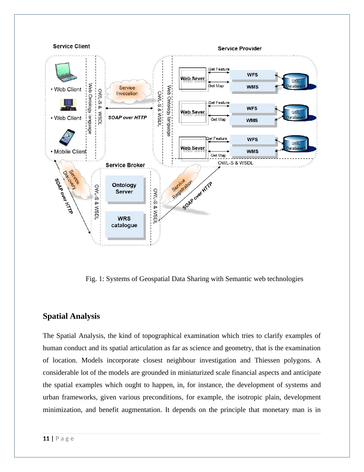
Fig. 1: Systems of Geospatial Data Sharing with Semantic web technologies
Spatial Analysis
The Spatial Analysis, the kind of topographical examination which tries to clarify examples of
human conduct and its spatial articulation as far as science and geometry, that is the examination
of location. Models incorporate closest neighbour investigation and Thiessen polygons. A
considerable lot of the models are grounded in miniaturized scale financial aspects and anticipate
the spatial examples which ought to happen, in, for instance, the development of systems and
urban frameworks, given various preconditions, for example, the isotropic plain, development
minimization, and benefit augmentation. It depends on the principle that monetary man is in
11 | P a g e
charge of the improvement of the scene, and is along these lines subject to the standard reactions
of that idea, for example, the absence of through and through freedom.
A differentiation is made in this course among GIS and spatial investigation. With regards to
standard GIS programming, the term investigation alludes to information control and information
questioning. With regards to spatial examination, the investigation centres around the factual
investigation of examples and hidden procedures or all the more, for the most part, spatial
examination tends to the inquiry "what could have been the beginning of the watched spatial
example?" It's an exploratory procedure whereby we endeavour to evaluate the watched example
at that point investigate the procedures that may have created the example.
Spatial Data Supply Chains (SDSC)
The cutting edge spatial frameworks must address numerous contemporaneous issues inside the
spatial data supply chains (SDSC). An SDSCs comprises of various worth include forms along
the chain. At each worth include point in the chain, there might be heterogeneous forms,
techniques, models and work processes consolidating to produce, adjust and expend spatial
information. The worth include procedures happening in coordinating and preparing numerous
informational collections brings up issues about information trust, quality, its qualification for a
reason, money and legitimate level. An explanation behind this is these informational collections
begun from various sources having had diverse forms executed upon them to touch base at this
last item. Knowing how information is gathered and what level of precision was utilized gives
understanding concerning what reason the information can be utilized for. The production of a
geospatial provenance model that catches these sorts of procedures will empower a capacity to
quantify how fit for reason information may be.
A huge amount of the Australian spatial information is gained at the neighbourhood government
level; it is then consolidated to frame the State or Territory level data sets and afterwards used to
make national-level data sets. Numerous procedures utilized in the spatial information age are
manual and undocumented just as certainly requiring human mediation. There is an absence of or
no connecting instruments at all between data sets. Numerous variants of informational
collections are additionally frequently being utilized which may prompt a mistaken or outdated
data set being utilized. There are conditions between the various information at various levels
12 | P a g e
including contrasting arrangements and human mediation. These variables muddle data set mix
at various levels.
In the country like Australia numerous associations at the nearby government level, inside state
government divisions in various wards just as Commonwealth offices, secure spatial information
for explicit territories or focal points autonomous of one another. This prompts information
duplication at numerous focuses along the SDSC. Absence of mindfulness or just because no
single data set suits different offices' needs, prompts this duplication.
Spatial data infrastructures (SDI)
The term spatial information foundation was instituted in 1993 by the U.S. National Research
Council to mean a structure of advancements, strategies, and institutional courses of action that
together encourage the creation, trade, and utilization of geospatial information and related data
assets over a data-sharing network. Such a structure can be executed barely to empower the
sharing of geospatial data inside an association or all the more extensively for use at a national,
local, or worldwide level. In all cases, an SDI will give an institutionally authorized, robotized
implies for posting, finding, assessing, and trading geospatial data by taking interest data makers
and clients. SDI expands a GIS by guaranteeing geospatial information and guidelines are
utilized to make definitive data sets and policies that help it.
The development of SDI (spatial data infrastructures) is intently connected with the endeavours
of gathering and creating geo-spatial information, just as the headway of studying and PC
innovations. In the previous decades, a lot of geo-spatial information, for example, remote
detecting pictures and GPS areas have been gathered by government offices, for example, the
U.S. Land Survey (USGS) and the National Oceanic and Atmospheric Administration (NOAA).
In the interim, the quick advancement of geographic data frameworks encourages the inference
of different information items from the gathered information, for example, topographic maps,
land spread information, transportation systems, and hydro-graphic highlights. As location‐based
administrations are ending up progressively well known, immense measures of volunteered
geographic data (VGI) (Goodchild 2007) has additionally been contributed by the overall
population through brilliant cell phones and web-based social networking stages. Furthermore,
the component of GIS brings geo-spatial administrations that give information preparing and
13 | P a g e
Paraphrase This Document
Need a fresh take? Get an instant paraphrase of this document with our AI Paraphraser
spatial investigation works in the general Web condition. The huge number of geo-spatial
information, administrations, maps, and others, be that as it may, don't facilitate the utilization of
these geospatial assets. On one hand, it is trying to discover and get to these advanced assets
which are generally conveyed at various government offices and sites (Li, Wang and Bhatia
2016). Then again, a lot of information redundancies exist, and cash and HR were squandered in
copied information accumulation and upkeep endeavours (Rajabifard and Williamson 2001,
Maguire and Longley 2005).
An SDI comprises of numerous parts. Notwithstanding the advanced geo-spatial assets, an SDI
likewise needs equipment, programming, individuals, associations, guidelines, strategies, and
numerous others to work appropriately. Developing an SDI additionally needs compelling
correspondences among networks, and exchanges among associations and even nations to arrive
at understandings. While an SDI has numerous segments, this section will especially concentrate
on geo-portals, metadata, and search capacities, which are three key parts of a common SDI.
Geo portals are ordinarily created utilizing Web‐based advancements and off‐the‐shelf GIS
programming bundles. A database the board framework (DBMS) is utilized to store and deal
with the metadata of the geospatial assets contained in the SDI. A Web interface, which
frequently contains a guide, empowers end clients to collaborate with the framework and to lead
look (Figure 2). At the point when a hunt is played out, an HTTP (Hypertext Transmission
Protocol) solicitation will be sent to the Web server which has the geo-portal. In the wake of
questioning the metadata put away in the database, the geo-portal will at that point send back the
outcome to the customer through an HTTP reaction. Geo-portals are regularly intended to be
utilized by the two GIS experts and the overall population.
Metadata give documentation on the substance and the generation procedure of geospatial assets.
Metadata are regularly called the information about information, and incorporate data, for
example, titles, portrayals, information classifications, the areas and time of the information
gathering, the information authorities, and the utilized arrange frameworks and guide projections,
and the information cleaning and preparing methods. Metadata can likewise be utilized for
portraying geo-spatial benefits by giving data about the information and capacities offered by the
14 | P a g e
administrations, the information and yield, the engineers, the advancement time, and others. So,
metadata are pretty much all parts of advanced geo-spatial assets.
The search capacities in SDIs are being improved by analysts. One of these enhancements lies in
text‐based search: there is a change from a keyword‐based search to the semantic inquiry.
Keyword‐based search inspects the coordinating between the catchphrases contribution by the
clients and the literary depictions of the geospatial assets. In this way, if a client types in the
street, the inquiry capacity won't have the option to discover the assets named as a road.
Semantic inquiry intends to coordinate advanced geospatial assets to client questions dependent
on the significance (semantics) of the inquiries, and accordingly can recognize applicable
information and administrations even though they are not marked with the precisely same words.
The Australian Spatial Data Infrastructure (ASDI)
The Australian Spatial Data Infrastructure (ASDI) is a national structure for connecting clients
with suppliers of spatial data and is comparative in idea to a national interstate or railroad
arrange. The ASDI contains the individuals, arrangements and advances important to empower
the utilization of spatially referenced information through all degrees of government, the private
area, non-benefit associations and the scholarly community.
A few components of the ASDI are now created, including approaches, rules, the Australian
Spatial Data Directory (ASDD), national information models, for example, ICSM's Harmonized
Data Model, metadata records and institutional game plans. Since its commencement in the
1990's the spatial condition has changed fundamentally. On-line frameworks carry a type of the
SDI to everybody, independent gadgets that know, think and convey (sensor systems) are getting
to be accessible and dynamic foundations are being built up. Web administrations are improving
the capacity of uses to get to the SDI. The idea of Virtual Australia has risen and been embraced
as a key activity by the CRC-SI together with undertakings to help the improvement of the
Australia New Zealand Spatial Market Place (ANZSM).
The Australian Spatial Data Directory (ASDD) has now been supplanted by FIND the Australian
Government's spatial information inventory and related to data.gov.au gives access to a system
15 | P a g e
of open government information. FIND enables you to look and download a wide scope of
spatially-referenced datasets made by both the Australian and State and Territory Governments.
To guarantee interoperability, the ASDI should depend on a lot of normal principles and
conventions, the utilization of which ought to be commanded and consistence checked and
implemented (RF-13). The present recognition that the utilization of models on little
undertakings is a superfluous cost should be adjusted with the goal that the long haul advantages
emerging from the informational index and business procedure reuse are acquired.
Customarily the ASDI has been characterized with a lot of crucial or system informational
indexes, to be specific: Geodetic, Hydrographic, Topography, Cadastral, Names and Addressing
(RF-23). While these sorts of informational indexes will stay significant as the ASDI advances,
extra information (at different scales and goals) should have the option to be incorporated into
the ASDI. The information ought to have the option to be included and evacuated all through the
ASDI's life expectancy. At last information dwelling inside the ASDI ought to be the
fundamental and definitive source, with information amendments and updates being made inside
the ASDI condition as opposed to the ASDI going about as an information vault holding a
duplicate of informational indexes.
Access Services characterize how Users get data and administrations. Access administrations
may give a way to get to a whole (or part of an) informational collection or be an increasingly
engaged conveyance of a spatially related capacity, for example, a location approval
administration.
Provenance for spatial analysis
The provenance utilization in improving information advancement has been recognized in
different spaces, including science, natural science, and software engineering [2]. Scientists in
these spaces regularly manage information serious issues utilizing a suite of computational
methodologies spoke to by Web administrations, work processes to get the infrastructure
capacities [2, 6]. Many refined investigation steps are regularly required to acquire attractive
answers for complex issues. To deliberately keep up history data of information investigation
16 | P a g e
Secure Best Marks with AI Grader
Need help grading? Try our AI Grader for instant feedback on your assignments.
and to empower the sharing of such data, information provenance data on information deduction
heredity and transformational procedures connected to information deduction is coupled with
information escalated computational methodologies. Specifically, since these computational
methodologies assume a significant job in GIS for geospatial information improvement and
scattering, it is basic to fuse provenance into GIS. The utilization of provenance in GIS can be
followed back to the information genealogy approach proposed by Lanter [10]. In any case, from
that point forward little work has been done to examine the job of provenance GIS being
developed and correspondence of geospatial learning. Since the novel attributes of GIS in spatial
information dealing with an investigation, extraordinary thought is frequently required for the
utilization of provenance to improve the explanatory capacities of GIS.
Information provenance, additionally called information genealogy, records the deduction
history of an information item. In the earth science space, geospatial information provenance is
significant because it assumes a noteworthy job in information quality and ease of use
assessment, information trail tryout, work process replication, and item reproducibility. The age
of the geospatial provenance metadata is normally combined with the execution of geo-handling
work process. Their cooperative relationship makes them corresponding to one another and
guarantees incredible advantage once they are coordinated. Notwithstanding, the heterogeneity
of information and figuring assets in the disseminated condition developed under the
administration arranged engineering (SOA) carries an incredible test to asset combination. In
particular, the issues, for example, the absence of interoperability and similarity among
provenance metadata models and provenance and work process, make snags for the coordination
of provenance, and geo-preparing work process.
The architecture of a Semantic Service
The system depends on Service Align Architecture and is an accumulation of OGC web
administrations, which speak with one another by basic information passing or planning a few
exercises. It is made out of four components: specialist organization, administration dealer,
administration customer, and cosmology server. Figure 2 below represents the four segments of
the proposed structure in the rationale universe. The specialist organization supplies geospatial
17 | P a g e
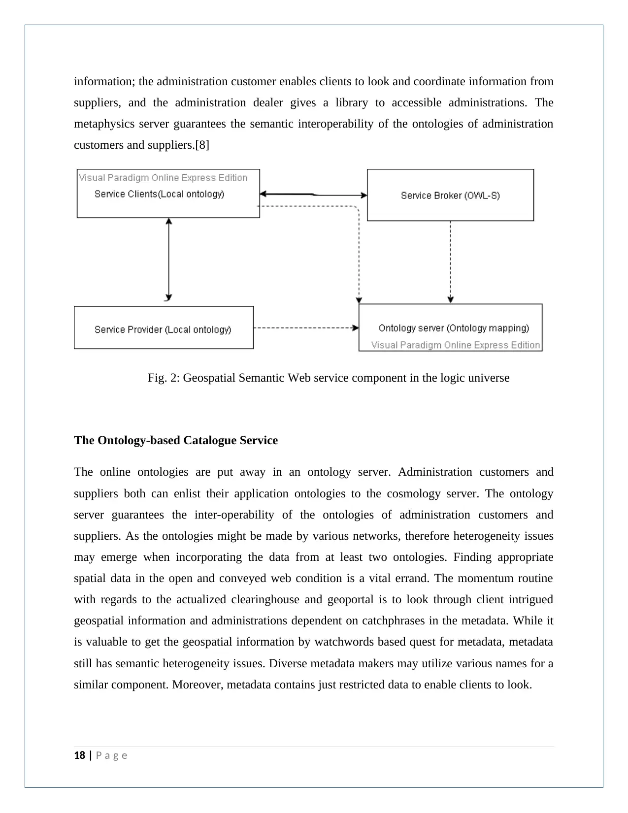
information; the administration customer enables clients to look and coordinate information from
suppliers, and the administration dealer gives a library to accessible administrations. The
metaphysics server guarantees the semantic interoperability of the ontologies of administration
customers and suppliers.[8]
Fig. 2: Geospatial Semantic Web service component in the logic universe
The Ontology-based Catalogue Service
The online ontologies are put away in an ontology server. Administration customers and
suppliers both can enlist their application ontologies to the cosmology server. The ontology
server guarantees the inter-operability of the ontologies of administration customers and
suppliers. As the ontologies might be made by various networks, therefore heterogeneity issues
may emerge when incorporating the data from at least two ontologies. Finding appropriate
spatial data in the open and conveyed web condition is a vital errand. The momentum routine
with regards to the actualized clearinghouse and geoportal is to look through client intrigued
geospatial information and administrations dependent on catchphrases in the metadata. While it
is valuable to get the geospatial information by watchwords based quest for metadata, metadata
still has semantic heterogeneity issues. Diverse metadata makers may utilize various names for a
similar component. Moreover, metadata contains just restricted data to enable clients to look.
18 | P a g e
Perception is one of the most significant and inescapable application zones of geospatial
information and in geographic data frameworks (GIS); it enables clients to investigate, blend,
present and break down the hidden geospatial information in an intelligent manner. However, the
representation of geospatial information discloses some long-standing difficulties to both the
suppliers and clients. One such test is the information combination issue, which can be the
coordination between geospatial information and furthermore between geospatial information
and information from different areas. At the interim, the perception of geospatial information is
additionally learning escalated from a cartographic point of view for both the suppliers and
clients. For the suppliers, a wide scope of cartographic hypotheses is required to infer sense-
making and cartographically palatable applications; and for the clients, the learning is required to
translate the displayed information importantly. Furthermore, now and again the clients need to
arrive at an abnormal state of subjective accord with the suppliers to all the more likely see the
conveyed data from the representation applications.
The objective of the Study
This research aims to produce a geospatial data provenance model. It will investigate and
implement semantic web techniques to aid the user in assessing the results of comprehensive
queries by linking provenance features with other information available from spatial systems.
The objective is to improve the accessibility and usability of spatial data at the country level, in
the first instance, but the techniques created will be generic and applicable to global use.
The administration of cadastral information includes different worth and supply chains. Every ha
heterogeneous geo-forms, strategies, models and work processes that join to create, alter and
convey spatial information. The coordination and handling of numerous datasets offer to ascend
to end client inquiries regarding trust, quality, and readiness for a reason, cash and definitiveness
of the information. This is because datasets start from different sources, and distinctive geo-
forms are executed to convey the last item. Seeing how information is gathered, prepared,
oversaw and scattered gives learning about its history, acceptability and provenance. This thusly
expands the convenience of information. [9] This research investigates strategies to catch spatial
19 | P a g e
Paraphrase This Document
Need a fresh take? Get an instant paraphrase of this document with our AI Paraphraser
information provenance and information stream genealogy. The point is to build up a spatial
information provenance model for the land organization area utilizing an exhaustive philosophy.
Also, this PhD proposition fundamentally researches how the Semantic Web innovations can
cultivate better coordination and perception of geospatial information, and thereof help the
exceeding of geospatial information, data and learning to different spaces. The extent of the PhD
proposal is expansive, and advantages raised by Semantic Web innovations will be shown in a
couple of specific situations where some customary geospatial issues are better tackled with the
Semantic Web. What's more, in this structure, ontologies and guidelines are seriously utilized as
two primary ideal models for learning portrayal.
20 | P a g e
Chapter 2
Background Study
According to the Merriam Webster lexicon, provenance is characterized as spot or wellspring of
the source where something was made or gathered alongside the records of their exercises
throughout proprietorship. Provenance may be utilized to decide genealogy, by following
advances engaged with sourcing, moving, and preparing of information [23] or how it touched
base in a specific database [3]. By account provenance, it is conceivable to accomplish a sound
ancestry record that guarantees reproducibility of significant information change [22]. Myers et
al. [15] contend that provenance record should be carefully discoverable, available, and
intelligible to empower legitimization and review support on how the information was delivered,
and give essential setting data to recreate information examination results. Three noteworthy
methodologies have been produced for provenance portrayal: explanation, reversal and virtual
information [20]. Explanation portrayal gives adaptability to create profoundly expressive
provenance that can be utilized to record data at various granularity levels. The granularity of
provenance additionally alluded to as provenance level is commonly delegated coarse or fine-
grained. The alluring degree of granularity of provenance relies upon application space
necessities, and the expense of accumulation, stockpiling and preparing. The better the
granularity of the provenance record the higher the data entropy and related expense. Reversal
strategies speak to capacities characterized alongside yield information that is adequate to
distinguish information sources. Reversal techniques permit a minimal portrayal of provenance
that empowers versatility. Be that as it may, these strategies are not all around relevant and the
data gave is restricted to information induction history. In virtual information frameworks, an
inventory is kept up for speaking to information induction techniques and inferred information,
giving adequate data to re-figure yield as required [7]. The ability of provenance in improving
critical thinking drives the utilization of provenance in the space of Geographic Information
Science known as GIScience. For instance, Lanter built up a meta-database framework for
following the procedure of the work process and a framework (Geolineus) for account Arc/Info
GIS activities [10, 11]. Alonso and Hagen [1] showed the plan of a geo-process supported work
process framework (Geo-Opera) that permits the following of geospatial examination history.
These frameworks or methodologies in the present GIS writing give just heredity data as changes
21 | P a g e
connected to determine information yet don't record and manage spatial provenance
methodically and strongly. Spatial provenance capacity in GIS makes spatial information taking
care of and examination mindful of their determination history and, consequently, is custom-
fitted to the portrayal and scattering of GIS-based learning.
Other than portrayal, provenance-mindful applications likewise need to guarantee provenance
catch, the board, and recovery (Miles et al. 2007). Provenance the board commonly includes the
utilization of a database or a Resource Description Framework (RDF) triple store. The recovery
of provenance information is through a SQL (Structured Query Language) or SPARQL
(Semantic Web Query Language) inquiry in a Semantic Web condition. This part of provenance
has been researched widely, e.g., in Buneman et al. (2001), Cui et al. (2000), Wang et al.
(2008b), Chebotko et al. (2010). Interestingly, the catch of information provenance, partic
ularly the components that are incorporated into a geo-processing work process is still new to the
GIScience people group. To a limited extent, this is because of the multifaceted nature of the
spatial investigation and the necessities to create, speak to, and move the provenance in a
programmed way. For instance, Tilmes et al. (2013) build up an idea model to introduce the
substance and provenance of the national atmosphere appraisal report created by the US Global
Change Research Program. This provenance model, utilizing W3C PROV, can be named a post-
occasion provenance since the provenance is caught after the appraisal on environmental change
is finished. Yue et al. (2011) create formal systems for sharing existing information provenance
through an expansion of the Open Geospatial Consortium (OGC) Eb-XML Registry Information
Model (Eb-RIM). In any case, provenance catch isn't tended to in this system. All the more as of
late, Di et al. (2013) exhibited a cutting edge answer for catching provenance while the
information is being created. The provenance, encoded in the ISO19115 ancestry model, is
progressively recorded when a web administration is executed by a Business Process Execution
Language (BPEL) motor.
22 | P a g e
Secure Best Marks with AI Grader
Need help grading? Try our AI Grader for instant feedback on your assignments.
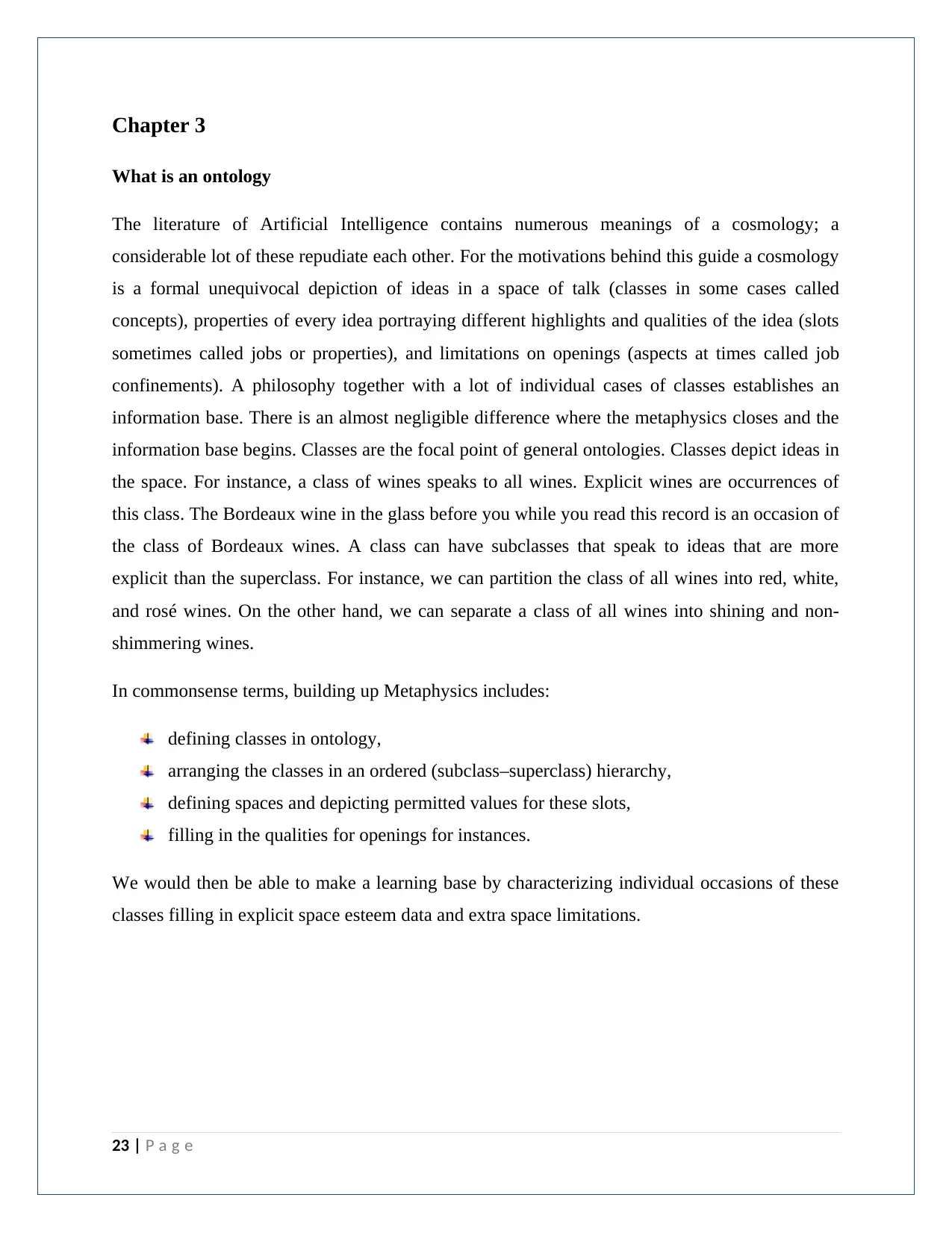
Chapter 3
What is an ontology
The literature of Artificial Intelligence contains numerous meanings of a cosmology; a
considerable lot of these repudiate each other. For the motivations behind this guide a cosmology
is a formal unequivocal depiction of ideas in a space of talk (classes in some cases called
concepts), properties of every idea portraying different highlights and qualities of the idea (slots
sometimes called jobs or properties), and limitations on openings (aspects at times called job
confinements). A philosophy together with a lot of individual cases of classes establishes an
information base. There is an almost negligible difference where the metaphysics closes and the
information base begins. Classes are the focal point of general ontologies. Classes depict ideas in
the space. For instance, a class of wines speaks to all wines. Explicit wines are occurrences of
this class. The Bordeaux wine in the glass before you while you read this record is an occasion of
the class of Bordeaux wines. A class can have subclasses that speak to ideas that are more
explicit than the superclass. For instance, we can partition the class of all wines into red, white,
and rosé wines. On the other hand, we can separate a class of all wines into shining and non-
shimmering wines.
In commonsense terms, building up Metaphysics includes:
defining classes in ontology,
arranging the classes in an ordered (subclass–superclass) hierarchy,
defining spaces and depicting permitted values for these slots,
filling in the qualities for openings for instances.
We would then be able to make a learning base by characterizing individual occasions of these
classes filling in explicit space esteem data and extra space limitations.
23 | P a g e
Fig 3. Ontology life cycle
Why develop ontology
Geo-spatial philosophy improvement and semantic learning revelation tends to the requirement
for displaying, investigating and imagining multi-modular data, and is novel in offering
coordinated systematic that envelops spatial, transient and topical components of data and
information. The extensive capacity to give incorporated examination from different types of
data and utilization of express information make this methodology interesting. This likewise
includes determination of spatial-transient topical ontologies and populating such ontologies with
excellent learning. Such ontologies structure the reason for characterizing the significance of
significant relations and terms, for example, close or encompassed by, and empower calculation
of spatial-worldly topical closeness estimates we characterize.
Lately the advancement of ontologies unequivocal formal details of the terms in the area and
relations among them [9] has been moving from the domain of Artificial-Intelligence research
24 | P a g e
facilities to the work areas of space specialists. Ontologies have turned out to be regular on the
World-Wide Web. The ontologies on the Web go from huge scientific classifications classifying
Web destinations, to orders of items available to be purchased and their highlights. The WWW
Consortium (W3C) is building up the Resource Description Framework [10], a language for
encoding learning on Web pages to make it reasonable to electronic operators looking for data.
The Defense Advanced Research Projects Agency (DARPA), related to the W3C, is creating
DARPA Agent Markup Language (DAML) by expanding RDF with progressively expressive
builds went for encouraging operator association on the Web [11]. Numerous controls currently
create institutionalized ontologies that area specialists can use to share and explain data in their
fields. The drug, for instance, has created enormous, institutionalized, organized vocabularies,
for example, SNOMED [8] and the semantic system of the Unified Medical Language System
(Humphreys and Lindberg 1993).
Ontologies Development Process
A philosophy characterizes a typical vocabulary for analysts. The information which changes
incredibly in size, extension and semantics is conceptualized dependent on an idea metaphysics,
which is the accomplishment of the semantic web accordingly the core of the semantic web.
Philosophy can be huge or little containing a huge number of terms and connections. These can
be made by information portrayal specialists or amateur web clients. Thus metaphysics picked up
its significance in research to share data in a specific space in machine decipherable
arrangement. Displaying specialists construct straightforward philosophy's and examples to enter
data effectively. Metaphysics together with a lot of individual examples of classes establish an
information base. Classes are the focal point of the general treasury. Classes portray ideas in the
area. A class can have sub-classes that speak to ideas that are more explicit than the superclass.
25 | P a g e
Paraphrase This Document
Need a fresh take? Get an instant paraphrase of this document with our AI Paraphraser
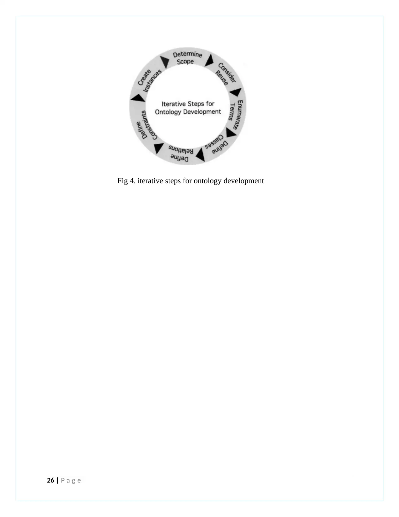
Fig 4. iterative steps for ontology development
26 | P a g e
26 | P a g e
System design
Here open source tools Protégé is used to evaluate for usability. Operational ontology
improvement conditions have concentrated so far on the altering of ontologies in an independent,
single-client mode. The developing of the Semantic Web and the Web 2.0 innovations carry
another test to the philosophy of proofreader suppliers, the cooperative altering of ontologies in
an electronic domain.
The Protege framework is an open-source metaphysics editor and learning base structure created
by Stanford Medical Informatics. It utilizes casing based portrayal formalism. The Protege
supervisor additionally underpins the altering of RDF and OWL3 ontologies.
27 | P a g e
Provenance Architecture in GIS
The need of joining provenance into GIS is as a rule progressively perceived, to a limited extent,
as a result of the rise of land organization framework and its appropriateness for information
escalated geospatial critical thinking. This paper tends to the requirements of provenance in GIS
and portrays a provenance-mindful GIS design and its verification of-idea usage. The
engineering depends on a conventional provenance model for the administration and utilization
of spatial provenance, which permits the fuse of explicit spatial provenance abilities. The
utilization cases exhibited are intended to be easy to uncover the capability of utilizing a-spatial,
spatial, spatiotemporal provenance information for GIS applications. The spatial locale is
presented as an essential reference unit for spatial provenance to digest the thought of both field-
and article based spatial information portrayals. The provenance-mindful GIS prototyped in this
examination can be stretched out to complex situations to help top to bottom thought of
provenance in GIS. Provenance in GIS can speak to causal connections among spatial
information and related examination methods. In our provenance-mindful GIS design,
provenance abilities are inexactly combined with GIS usage and don't require any new
improvement interior to spatial databases. Our execution sorts out spatial provenance as items in
spatial information store, while a-spatial procedure provenance will be spoken to utilizing
semantic web innovations. This blend empowers a suite of provenance related tasks, including
capacity and recovery. The free coupling procedure is proper to exploit nonexclusive provenance
capacities that are stretched out with the capacity to deal with spatial provenance.
An administration arranged three-layered design as shown in the following Figure is created to
help GIS to record and inquiry spatial provenance. The Web-administrations level encourages
the capacity and inquiry of provenance from GIS applications. The base information level
comprises of a semantic information storehouse and a spatial information store. The centre
rationale level is made out of a lot of modules and extensions the top and base levels. This
engineering gives an extensible and versatile system in which administrations and modules can
be included and refreshed without disturbing leaving GIS usefulness. The design is especially
appropriate to provenance recording at a coarse-grained level in that recorded provenance in this
investigation is controlled at the degree of spatial districts instead of spatial articles. Spatial
areas, undifferentiated from the thought of "fields of spatial items", are a theoretical term to think
28 | P a g e
Secure Best Marks with AI Grader
Need help grading? Try our AI Grader for instant feedback on your assignments.
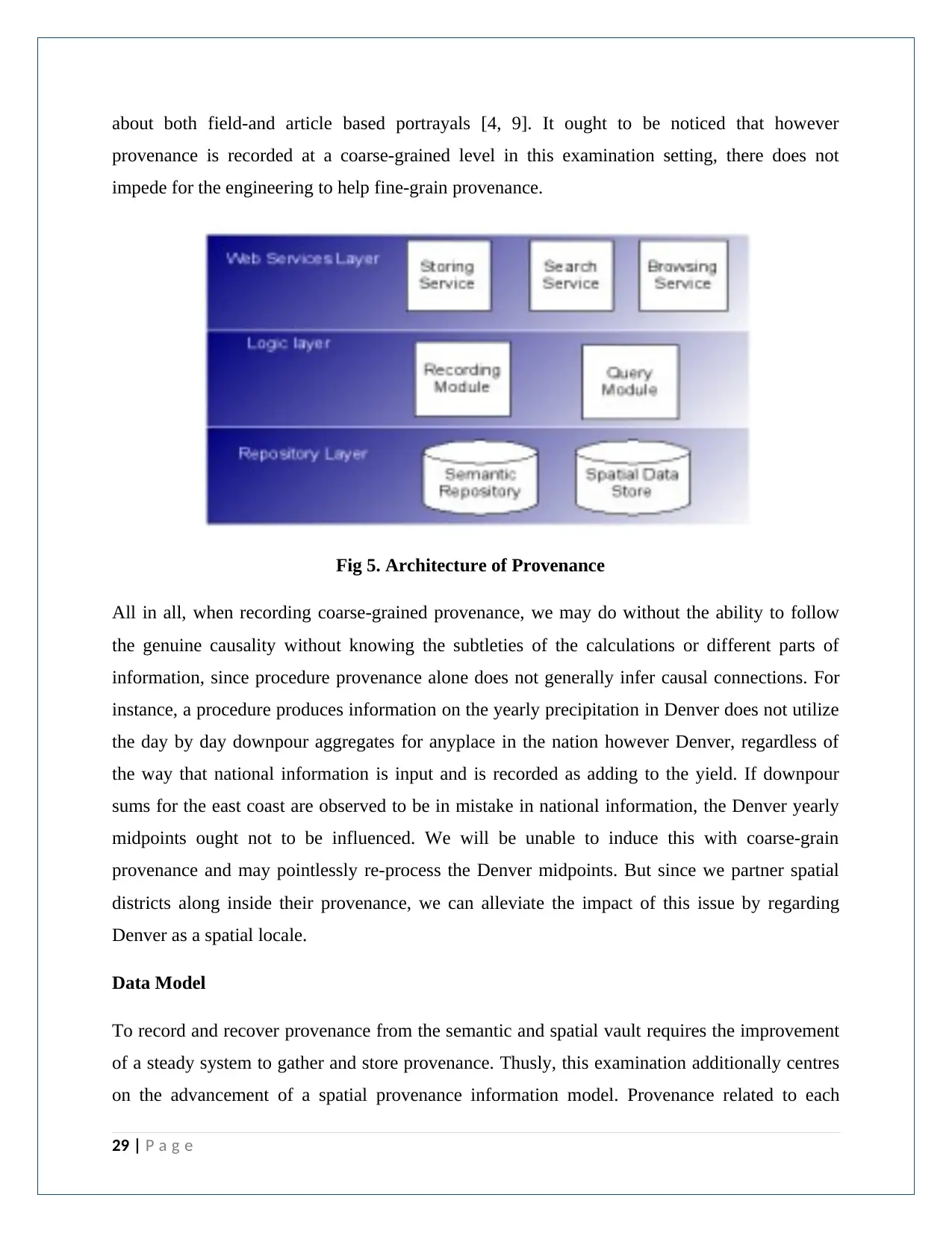
about both field-and article based portrayals [4, 9]. It ought to be noticed that however
provenance is recorded at a coarse-grained level in this examination setting, there does not
impede for the engineering to help fine-grain provenance.
Fig 5. Architecture of Provenance
All in all, when recording coarse-grained provenance, we may do without the ability to follow
the genuine causality without knowing the subtleties of the calculations or different parts of
information, since procedure provenance alone does not generally infer causal connections. For
instance, a procedure produces information on the yearly precipitation in Denver does not utilize
the day by day downpour aggregates for anyplace in the nation however Denver, regardless of
the way that national information is input and is recorded as adding to the yield. If downpour
sums for the east coast are observed to be in mistake in national information, the Denver yearly
midpoints ought not to be influenced. We will be unable to induce this with coarse-grain
provenance and may pointlessly re-process the Denver midpoints. But since we partner spatial
districts along inside their provenance, we can alleviate the impact of this issue by regarding
Denver as a spatial locale.
Data Model
To record and recover provenance from the semantic and spatial vault requires the improvement
of a steady system to gather and store provenance. Thusly, this examination additionally centres
on the advancement of a spatial provenance information model. Provenance related to each
29 | P a g e
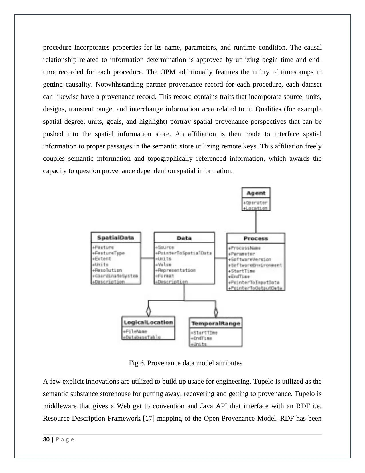
procedure incorporates properties for its name, parameters, and runtime condition. The causal
relationship related to information determination is approved by utilizing begin time and end-
time recorded for each procedure. The OPM additionally features the utility of timestamps in
getting causality. Notwithstanding partner provenance record for each procedure, each dataset
can likewise have a provenance record. This record contains traits that incorporate source, units,
designs, transient range, and interchange information area related to it. Qualities (for example
spatial degree, units, goals, and highlight) portray spatial provenance perspectives that can be
pushed into the spatial information store. An affiliation is then made to interface spatial
information to proper passages in the semantic store utilizing remote keys. This affiliation freely
couples semantic information and topographically referenced information, which awards the
capacity to question provenance dependent on spatial information.
Fig 6. Provenance data model attributes
A few explicit innovations are utilized to build up usage for engineering. Tupelo is utilized as the
semantic substance storehouse for putting away, recovering and getting to provenance. Tupelo is
middleware that gives a Web get to convention and Java API that interface with an RDF i.e.
Resource Description Framework [17] mapping of the Open Provenance Model. RDF has been
30 | P a g e
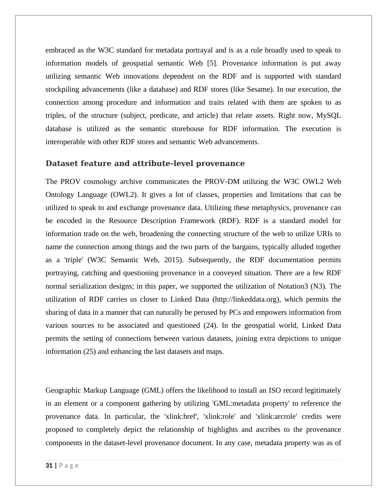
embraced as the W3C standard for metadata portrayal and is as a rule broadly used to speak to
information models of geospatial semantic Web [5]. Provenance information is put away
utilizing semantic Web innovations dependent on the RDF and is supported with standard
stockpiling advancements (like a database) and RDF stores (like Sesame). In our execution, the
connection among procedure and information and traits related with them are spoken to as
triples, of the structure (subject, predicate, and article) that relate assets. Right now, MySQL
database is utilized as the semantic storehouse for RDF information. The execution is
interoperable with other RDF stores and semantic Web advancements.
Dataset feature and attribute-level provenance
The PROV cosmology archive communicates the PROV-DM utilizing the W3C OWL2 Web
Ontology Language (OWL2). It gives a lot of classes, properties and limitations that can be
utilized to speak to and exchange provenance data. Utilizing these metaphysics, provenance can
be encoded in the Resource Description Framework (RDF). RDF is a standard model for
information trade on the web, broadening the connecting structure of the web to utilize URIs to
name the connection among things and the two parts of the bargains, typically alluded together
as a 'triple' (W3C Semantic Web, 2015). Subsequently, the RDF documentation permits
portraying, catching and questioning provenance in a conveyed situation. There are a few RDF
normal serialization designs; in this paper, we supported the utilization of Notation3 (N3). The
utilization of RDF carries us closer to Linked Data (http://linkeddata.org), which permits the
sharing of data in a manner that can naturally be perused by PCs and empowers information from
various sources to be associated and questioned (24). In the geospatial world, Linked Data
permits the setting of connections between various datasets, joining extra depictions to unique
information (25) and enhancing the last datasets and maps.
Geographic Markup Language (GML) offers the likelihood to install an ISO record legitimately
in an element or a component gathering by utilizing 'GML:metadata property' to reference the
provenance data. In particular, the 'xlink:href', 'xlink:role' and 'xlink:arcrole' credits were
proposed to completely depict the relationship of highlights and ascribes to the provenance
components in the dataset-level provenance document. In any case, metadata property was as of
31 | P a g e
Paraphrase This Document
Need a fresh take? Get an instant paraphrase of this document with our AI Paraphraser
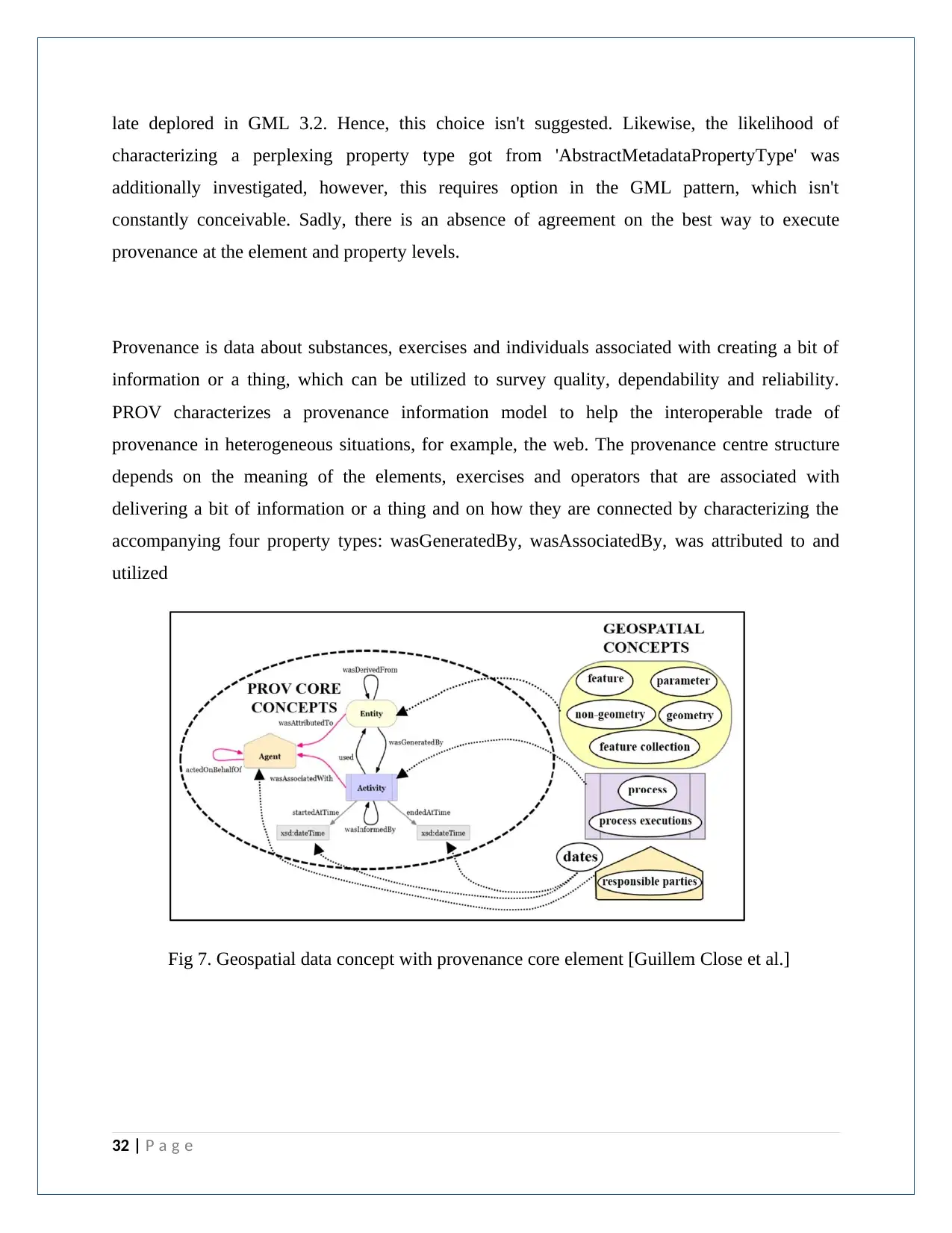
late deplored in GML 3.2. Hence, this choice isn't suggested. Likewise, the likelihood of
characterizing a perplexing property type got from 'AbstractMetadataPropertyType' was
additionally investigated, however, this requires option in the GML pattern, which isn't
constantly conceivable. Sadly, there is an absence of agreement on the best way to execute
provenance at the element and property levels.
Provenance is data about substances, exercises and individuals associated with creating a bit of
information or a thing, which can be utilized to survey quality, dependability and reliability.
PROV characterizes a provenance information model to help the interoperable trade of
provenance in heterogeneous situations, for example, the web. The provenance centre structure
depends on the meaning of the elements, exercises and operators that are associated with
delivering a bit of information or a thing and on how they are connected by characterizing the
accompanying four property types: wasGeneratedBy, wasAssociatedBy, was attributed to and
utilized
Fig 7. Geospatial data concept with provenance core element [Guillem Close et al.]
32 | P a g e
References:
[1] Janowicz, K., Schade, S., Bröring, A., Keßler, C., Maué, P., Stasch, C. (2010) Semantic
enablement for spatial data infrastructures. Transactions in GIS 14,111-129.
[2] Zhang, C. and Li, W. (2005) The roles of Web Feature and Web Map Services in real-
time geospatial data sharing for time-critical applications, Cartography and Geographic
Information Science, vol.32, no. 4, pp. 269-283.
[3] F. Hakimpour, S. Timpf, "Using ontologies for resolution of semantic heterogeneity in GIS,"
Paper presented at the Proceedings of 4th AGILE Conference on Geographic Information
Science, Brno (2001).
[4] I. Suriarachchi, “Survey of Provenance Practices in Data Preservation Repositories,”
https://www.rd-alliance.org/filedepot, [Last Accessed: 29/05/2015]
[5]Lianlian He; Peng Yue; Liping Di; Mingda Zhang; Lei Hu, "Adding Geospatial Data
Provenance into SDI—A Service-Oriented Approach," in Selected Topics in Applied Earth
Observations and Remote Sensing, IEEE Journal of , vol.8, no.2, pp.926-936, Feb. 2015
[6]T. Liu,., S. Yanfeng, D. Smith, A.Terhorst, “Provenance-Aware Automated Data Quality
Control”, Paper presented at the eResearch Australasia 2011, Melbourne. Conference
Material retrieved from http://conference.eresearch.edu.au/eres2011/ presentations/.
[7]G. West,“Research Strategy Spatial Infrastructure, (Program 3)”. Updated.
Retrieved: March 2016, from www.crcsi.com.au/Resources/ Research/ P3-final-
Research-Strategy.aspx
[8] Zhang, C., Li, W., Day, M. and Peng, Z.R. (2003) GML-based interoperable
geographical database, Cartography, vol. 32, no. 2, pp.1-16.
[9] Muhammad Azeem Sadiq et. al., (2016). Spatial Data Supply Chain Provenance Modelling
for Next Generation Spatial Infrastructures Using Semantic Web Technologies. GEOProcessing
2016 : The Eighth International Conference on Advanced Geographic Information Systems,
Applications, and Services
33 | P a g e
[10] Brickley, D. and Guha, R.V. (1999). Resource Description Framework (RDF) Schema
Specification. Proposed Recommendation, World Wide Web
Consortium: http://www.w3.org/TR/PR-rdf-schema
[11] Hendler, J. and McGuinness, D.L. (2000). The DARPA Agent Markup Language. IEEE
Intelligent Systems 16(6): 67-73.
[12] Price, C. and Spackman, K. (2000). SNOMED clinical terms. BJHC&IM-British Journal of
Healthcare Computing & Information Management 17(3): 27-31.
[13] Humphreys, B.L. and Lindberg, D.A.B. (1993). The UMLS project: making the conceptual
connection between users and the information they need. Bulletin of the Medical Library
Association 81(2): 170
[14] D.P. Lanter. Design of a lineage-based meta-database for GIS. Cartography and Geographic
Information Systems, 18(4), pp 255-261, 1991
[15] D. P. Lanter. A Lineage Meta-Database Approach Toward Spatial Analytic Database Optimization.
Cartography and Geographic Information Systems v.20(2), pp 112-121, 1993.
[16] L. Moreau and I. Foster (Eds.). Provenance and Annotation of Data - International Provenance and
Annotation Workshop, IPAW 2006 (Lecture Notes in Computer Science, vol. 4145). Springer: Berlin,
2006.
[17] L. Moreau, J. Freire, J. Futrelle, R. McGrath, J. Myers and P. Paulson. The Open Provenance Model,
http://eprints.ecs.soton.ac.uk/14979/1/opm.pdf, 2007.
[18] L. Moreau., P. Groth, S. Miles, J. Vazquez-Salceda, J. Ibbotson, S. Jiang, S. Munroe and O. Rana, A.
Schreiber, V. Tan, L. Varga. The provenance of electronic data. Communications of. ACM 51, 4, pp 52-58,
Apr. 2008.
[19] J. D. Myers, J. Futrelle, J. Gaynor, J. Plutchak, P. Bajcsy, J. Kastner, K. Kotwani, J.S. Lee, L. Marini,
R.E.McGrath and Y. Liu. Embedding Data within Knowledge Spaces. In UK escience 2008, Edinburgh, UK,
Sept 2008.
34 | P a g e
Secure Best Marks with AI Grader
Need help grading? Try our AI Grader for instant feedback on your assignments.
[20] M. Perry, F. Hakimpour, A. Sheth. Analyzing Theme, Space and Time: An Ontology-based Approach.
14th International Symposium on Advances in Geographic Information Systems (ACM-GIS '06),
Arlington, VA, pp. 147-154, Nov, 2006
[21] Resource Description Framework (RDF): Concepts and Abstract Syntax. W3C Recommendation.
http://www.w3.org/ TR/rdf-concepts/. Feb, 2004.
[22] A. Sheth and M. Perry. Traveling the Semantic Web through Space, Time and Theme. IEEE Internet
Computing, v. 12(2), pp. 81-86, March/April 2008.
[23] S. S. Sahoo, A. Sheth, and C. Henson. Semantic Provenance for eScience: Managing the Deluge of
Scientific Data. IEEE Internet Computing, v. 12(4), pp. 46-54, 2008.
[24] Y. Simmhan, B. Plale and D. Gannon. A Survey of Data Provenance in e-science. In SIGMOD Record,
v. 34, pp 31-36, 2005.
[25] SPARQL Query Language for RD. W3C Recommendation. http://www.w3.org/TR/rdf-sparql-query/,
Jan 2008.
[26] M. Szomszor and L. Moreau. Recording and reasoning over data provenance in Web and grid
services. In International Conference on Ontologies, Databases and Applications of Semantics
(ODBASE'03), pp 603-620, Nov 2003.
[27] C. Bizer, T. Heath, T. Berners-Lee Linked data—The story so far International Journal on
Semantic Web and Information Systems, 5 (3) (2009), pp. 1-22
[28] L.M. Vilches-Blázquez, B. Villazón-Terrazas, O. Corcho, A. Gómez-Pérez Integrating
geographical information in the linked digital earth International Journal of Digital Earth, 7 (7)
(2014), pp. 554-575, 10.1080/17538947.2013.783127
[29] Hu, Y., K. Janowicz, S. Prasad & S. Gao (2015) Metadata Topic Harmonization and
Semantic Search for Linked‐Data‐Driven Geoportals: A Case Study Using ArcGIS Online.
TransactionsinGIS,19, 398‐416.
[30] Li, W., V. Bhatia & K. Cao (2015) Intelligent polar cyber infrastructure: enabling semantic
search in geospatial metadata catalogue to support polar data discovery. Earth Science
Informatics, 8,111‐123.
35 | P a g e
[31] Li, W., S. Wang & V. Bhatia (2016) Polar Hub: A large‐scale web crawling engine for
OGC service discovery in cyber infrastructure. Computers, Environment and Urban Systems, 59,
195‐207.
[32] Li, W., X. Zhou & S. Wu (2016) An Integrated Software Framework to Support Semantic
Modeling and Reasoning of Spatiotemporal Change of Geographical Objects: A Use Case of
Land Use and Land Cover Change Study. ISPRS International Journal of Geo‐Information, 5,
179.
36 | P a g e
1 out of 36
Your All-in-One AI-Powered Toolkit for Academic Success.
+13062052269
info@desklib.com
Available 24*7 on WhatsApp / Email
![[object Object]](/_next/static/media/star-bottom.7253800d.svg)
Unlock your academic potential
© 2024 | Zucol Services PVT LTD | All rights reserved.