Analysis of the 2004 Indian Ocean Earthquake and Tsunami
VerifiedAdded on 2022/08/12
THE INDIAN OCEAN EARTHQUAKE AND TSUNAMI
Name of the Student
Name of the University
Author Note:
Paraphrase This Document
The body of salt water that covers almost one-fifth of the entire ocean area of the world.
According to the study, Indian Ocean is the smallest and geographically recent and with most
complex physical location comparing the other three major oceans. The ocean stretches almost
6,200 miles among the southern range of Africa and Australia. Without considering the marginal
seas, the areas of the Indian Ocean covers include 28,360,000 square miles1. Considering the
world map, the Indian Ocean is surrounded by Iran, India, Bangladesh, Pakistan (North), Malay
Peninsula, Sunda Islands of Indonesia, and Australia (East), Antarctica (South), Africa and
Arabian Peninsula (West). Takewak and Izuru (2013) mentioned that the climate of the Indian
ocean is one of the unique kinds. The main component of its climate is the large scale Tropical
Warm Pool. During the interaction with the atmosphere this warm pool affects the climate
globally as well as regionally. Asia prevents the heat and ventilation of the thermocline of the
Indian Ocean2. It also drives the monsoon of the Indian Ocean. Hence, the paper aims to dig out
more information about Indian Ocean and the causes of natural disasters including Tsunami
and Earthquake in this region. The paper will provide more stress on the Tsunami on Indian
Ocean in the year 2004 along with its consequences.
1 Puthezhath, ARJUN S. "Identification of thermal fronts in the Arabian sea using MODIS-SST data." Kerala
University Of Fisheries And Ocean Studies. Panangad (2014).
2 Hutchison, Emma. "A global politics of pity? Disaster imagery and the emotional construction of solidarity after
the 2004 Asian tsunami." International Political Sociology 8, no. 1 (2014): 1-19
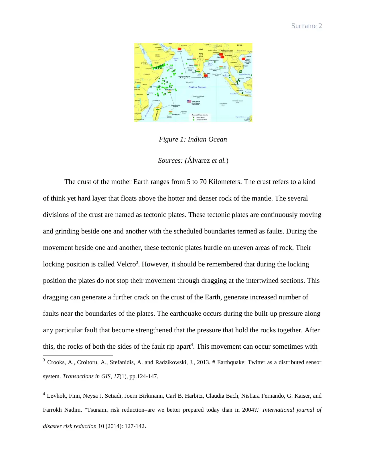
Figure 1: Indian Ocean
Sources: (Álvarez et al.)
The crust of the mother Earth ranges from 5 to 70 Kilometers. The crust refers to a kind
of think yet hard layer that floats above the hotter and denser rock of the mantle. The several
divisions of the crust are named as tectonic plates. These tectonic plates are continuously moving
and grinding beside one and another with the scheduled boundaries termed as faults. During the
movement beside one and another, these tectonic plates hurdle on uneven areas of rock. Their
locking position is called Velcro3. However, it should be remembered that during the locking
position the plates do not stop their movement through dragging at the intertwined sections. This
dragging can generate a further crack on the crust of the Earth, generate increased number of
faults near the boundaries of the plates. The earthquake occurs during the built-up pressure along
any particular fault that become strengthened that the pressure that hold the rocks together. After
this, the rocks of both the sides of the fault rip apart4. This movement can occur sometimes with
3 Crooks, A., Croitoru, A., Stefanidis, A. and Radzikowski, J., 2013. # Earthquake: Twitter as a distributed sensor
system. Transactions in GIS, 17(1), pp.124-147.
4 Løvholt, Finn, Neysa J. Setiadi, Joern Birkmann, Carl B. Harbitz, Claudia Bach, Nishara Fernando, G. Kaiser, and
Farrokh Nadim. "Tsunami risk reduction–are we better prepared today than in 2004?." International journal of
disaster risk reduction 10 (2014): 127-142.
⊘ This is a preview!⊘
Do you want full access?
Subscribe today to unlock all pages.

Trusted by 1+ million students worldwide
a supersonic speed. Both the sides of the fault passing one another leave a pent-up pressure.
These energy from the divisions radiates outward covering all the direction and involves the
surface area also that is felt like an earthquake.
The geophysicist Løvholt (2014) mentioned that the tectonic plates of the Earth’s crust
slide on a regular basis. The way the faults release the preserved energy is observed differently
during each and every earthquake. Every earthquake is not identical and the effects of the
earthquakes are not same always. According to the researchers there is no regularity connected
with the activities of earthquake5. The large earthquakes often succeeded by some aftershocks.
These aftershocks provide smaller quakes which are the outcome of the main shock and the
adjustment of the crusts. Scientists and geophysicist can target or find out the source of the
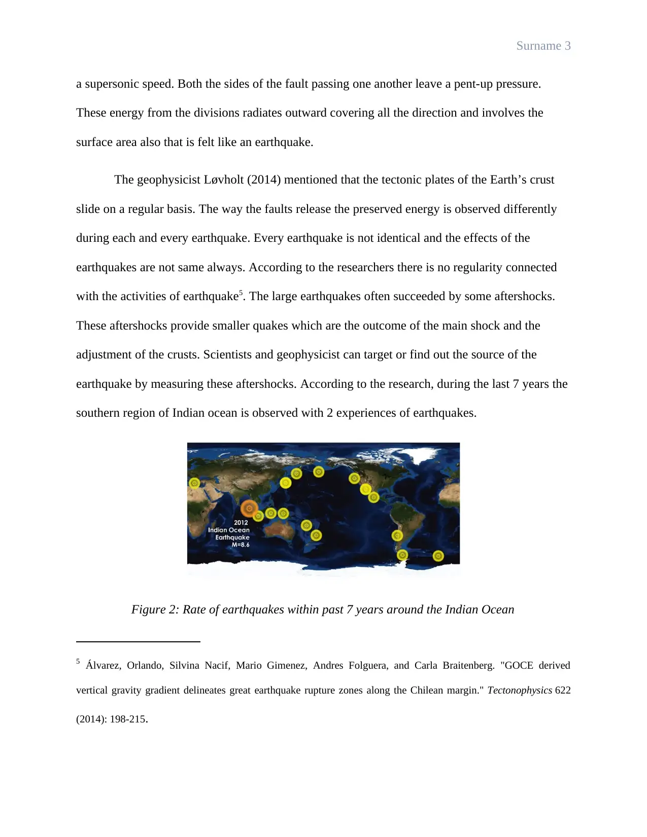
earthquake by measuring these aftershocks. According to the research, during the last 7 years the
southern region of Indian ocean is observed with 2 experiences of earthquakes.
Figure 2: Rate of earthquakes within past 7 years around the Indian Ocean
5 Álvarez, Orlando, Silvina Nacif, Mario Gimenez, Andres Folguera, and Carla Braitenberg. "GOCE derived
vertical gravity gradient delineates great earthquake rupture zones along the Chilean margin." Tectonophysics 622
(2014): 198-215.
Paraphrase This Document
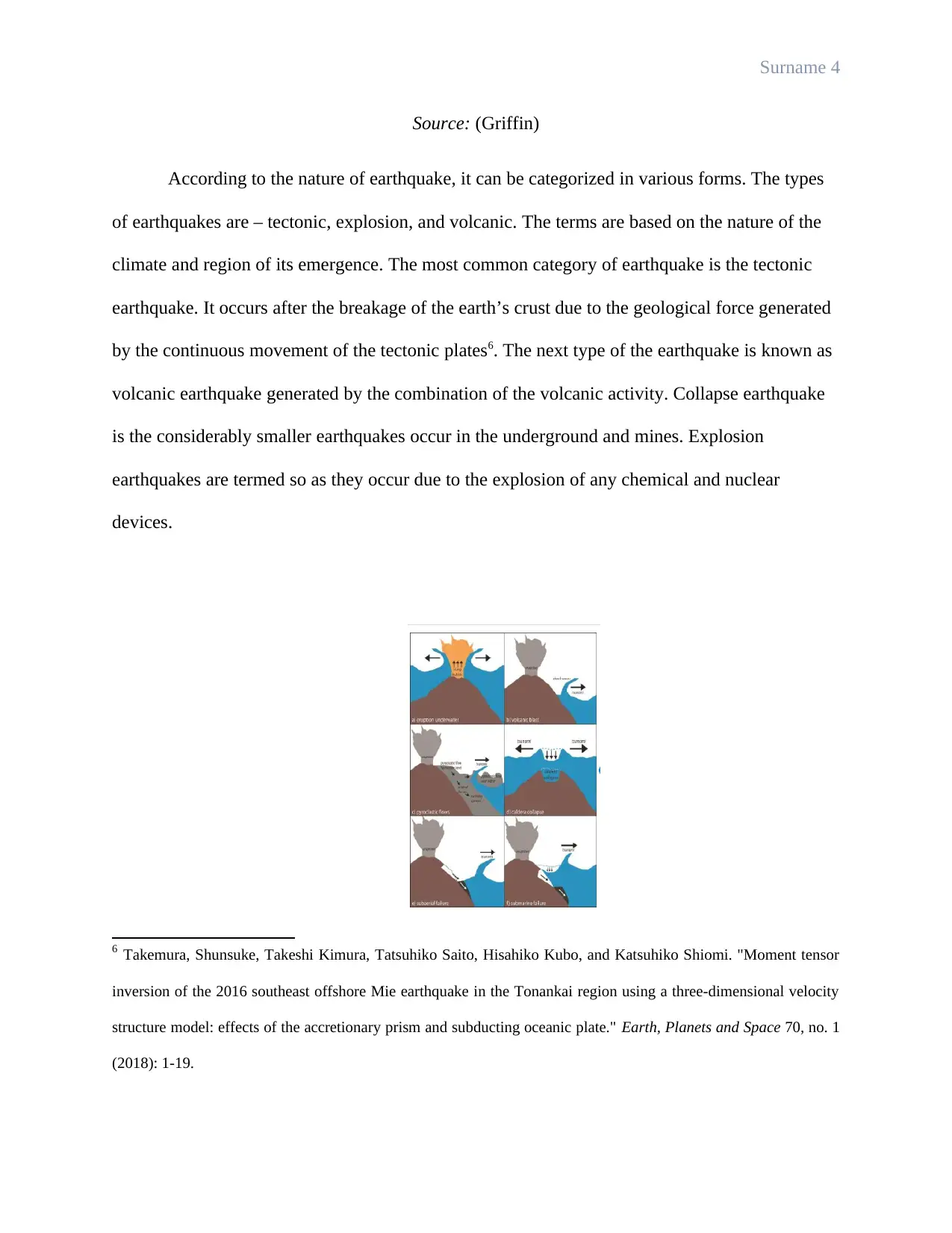
Source: (Griffin)
According to the nature of earthquake, it can be categorized in various forms. The types
of earthquakes are – tectonic, explosion, and volcanic. The terms are based on the nature of the
climate and region of its emergence. The most common category of earthquake is the tectonic
earthquake. It occurs after the breakage of the earth’s crust due to the geological force generated
by the continuous movement of the tectonic plates6. The next type of the earthquake is known as
volcanic earthquake generated by the combination of the volcanic activity. Collapse earthquake
is the considerably smaller earthquakes occur in the underground and mines. Explosion
earthquakes are termed so as they occur due to the explosion of any chemical and nuclear
devices.
6 Takemura, Shunsuke, Takeshi Kimura, Tatsuhiko Saito, Hisahiko Kubo, and Katsuhiko Shiomi. "Moment tensor
inversion of the 2016 southeast offshore Mie earthquake in the Tonankai region using a three-dimensional velocity
structure model: effects of the accretionary prism and subducting oceanic plate." Earth, Planets and Space 70, no. 1
(2018): 1-19.
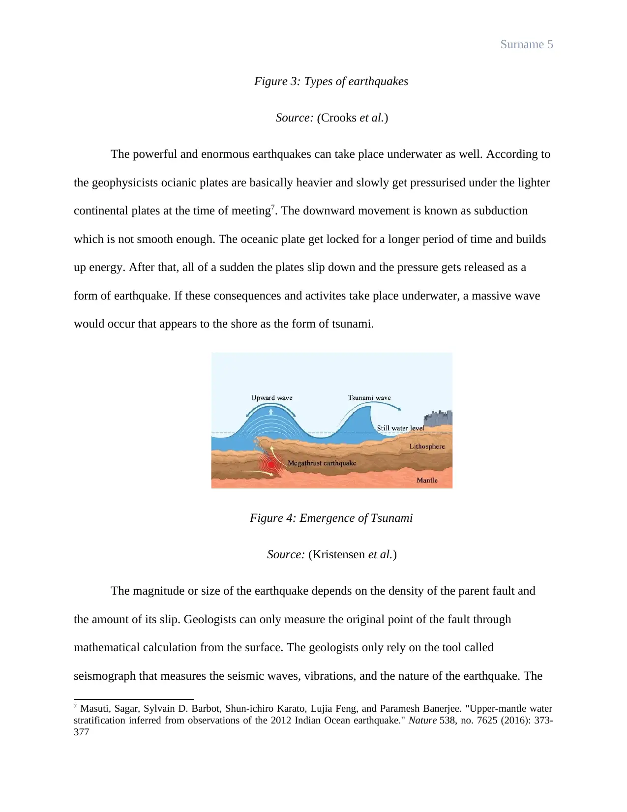
Figure 3: Types of earthquakes
Source: (Crooks et al.)
The powerful and enormous earthquakes can take place underwater as well. According to
the geophysicists ocianic plates are basically heavier and slowly get pressurised under the lighter
continental plates at the time of meeting7. The downward movement is known as subduction
which is not smooth enough. The oceanic plate get locked for a longer period of time and builds
up energy. After that, all of a sudden the plates slip down and the pressure gets released as a
form of earthquake. If these consequences and activites take place underwater, a massive wave
would occur that appears to the shore as the form of tsunami.
Figure 4: Emergence of Tsunami
Source: (Kristensen et al.)
The magnitude or size of the earthquake depends on the density of the parent fault and
the amount of its slip. Geologists can only measure the original point of the fault through
mathematical calculation from the surface. The geologists only rely on the tool called
seismograph that measures the seismic waves, vibrations, and the nature of the earthquake. The
7 Masuti, Sagar, Sylvain D. Barbot, Shun-ichiro Karato, Lujia Feng, and Paramesh Banerjee. "Upper-mantle water
stratification inferred from observations of the 2012 Indian Ocean earthquake." Nature 538, no. 7625 (2016): 373-
377
⊘ This is a preview!⊘
Do you want full access?
Subscribe today to unlock all pages.

Trusted by 1+ million students worldwide
magnitude of an earthquake is measured by the magnitude scale. This scale provides more
detailed idea about the shaking and the probable damage that can be occurred from the
earthquakes covering the entire world. It is not the Richter scale that measure the magnitude of
earthquake.
The earthquake with the lesser magnitude than 3 is an exmaple of daily occurance and
general people cannot feel it. The magnitude between 3-5 is known as minor earthquake and the
quakes with the magnitude ranging from 5 to 7 are moderate and strong. All above these
earthquake can be destructive for an entire city. Earthquakes with the magnitude of 7 to 8 are the
major quakes and almost 15 major earthquakes occur annually. Earthquake with the magnitude
range of 10 has been never observed, however, the occurance of this earthquake can destroy the
entire universe.
In simple word, it can be said that tsunami is the chronology of waves commonly
occurred by the consequences of an earthquake underneath an ocean. The aftereffects of tsunami
can bring several damages for the coastal areas. The larger the tsunamis the greater the
consequences the surrounded area face. Probable hazardous situations can be occurred by a
tsunami are mentionind in the following section. Small tsunamis are non-desgtructive in nature.
They usually occur too far from the land and the sizes are too small to measure. Small tsunamis
are often resutl in high and quick movement of the tide. Tsunamis possess longer periods and can
reduce the issues of gulfs, islands, and bays. These tsunamis usually results into heavy landfalls
and can bring sudden desline in the weather and rapid growth of the water levels. Basically
tsunamis appear as a form of large and heavy tide with the image of a flood.
In case of the occurance of high scale tsunami, the devastating picture grows stronger for
the coastal areas. It causes in property damage and loss of life. According to the study, a tiny
Paraphrase This Document
wave of 30 centimeters can grow into devastating monster wave with 30m high to sweep over
the entire coastal area8. The initial wave of the tsunami is extraordinarily tall. Maximum damages
are caused by the extreme amount of water initiated by the primary wave. The height of the sea
continuously rise fast and appears as a flood for the surrounding coastal areas. The destruction
caused by tsunami can be categorised in two main categories. It includes the smashing energy of
the wall of water appearing with an extreme speed9. On the other hand, the power of destruction
associated with the wave to carry off the land and carries almost every thing with it.
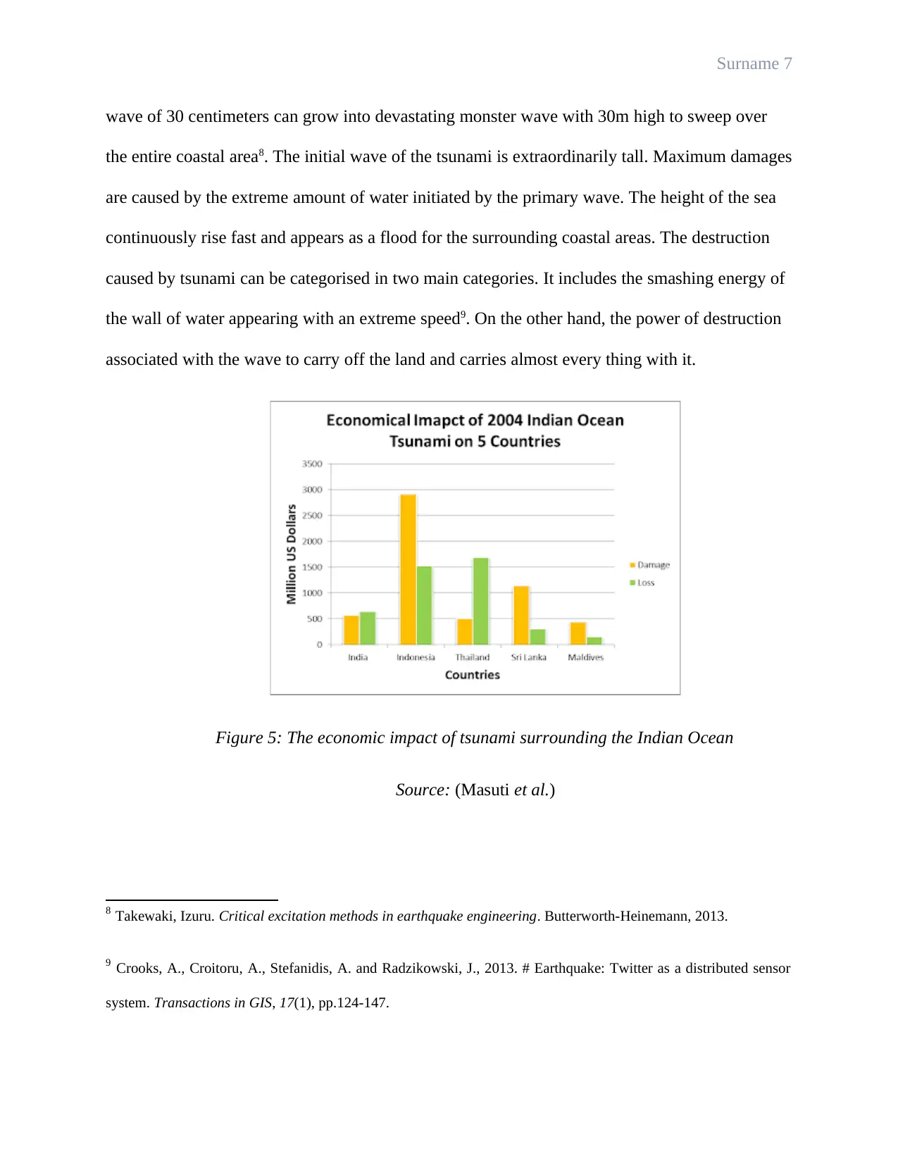
Figure 5: The economic impact of tsunami surrounding the Indian Ocean
Source: (Masuti et al.)
8 Takewaki, Izuru. Critical excitation methods in earthquake engineering. Butterworth-Heinemann, 2013.
9 Crooks, A., Croitoru, A., Stefanidis, A. and Radzikowski, J., 2013. # Earthquake: Twitter as a distributed sensor
system. Transactions in GIS, 17(1), pp.124-147.
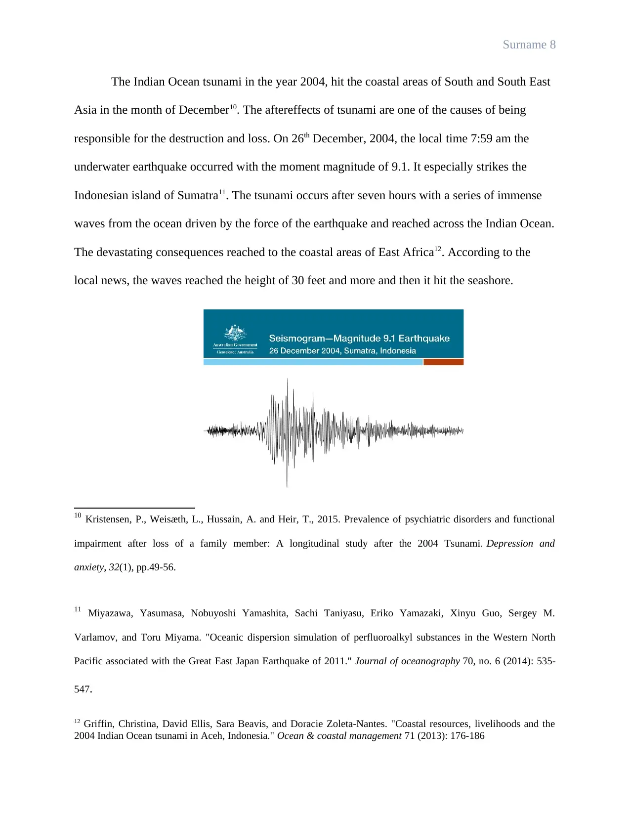
The Indian Ocean tsunami in the year 2004, hit the coastal areas of South and South East
Asia in the month of December10. The aftereffects of tsunami are one of the causes of being
responsible for the destruction and loss. On 26th December, 2004, the local time 7:59 am the
underwater earthquake occurred with the moment magnitude of 9.1. It especially strikes the
Indonesian island of Sumatra11. The tsunami occurs after seven hours with a series of immense
waves from the ocean driven by the force of the earthquake and reached across the Indian Ocean.
The devastating consequences reached to the coastal areas of East Africa12. According to the
local news, the waves reached the height of 30 feet and more and then it hit the seashore.
10 Kristensen, P., Weisæth, L., Hussain, A. and Heir, T., 2015. Prevalence of psychiatric disorders and functional
impairment after loss of a family member: A longitudinal study after the 2004 Tsunami. Depression and
anxiety, 32(1), pp.49-56.
11 Miyazawa, Yasumasa, Nobuyoshi Yamashita, Sachi Taniyasu, Eriko Yamazaki, Xinyu Guo, Sergey M.
Varlamov, and Toru Miyama. "Oceanic dispersion simulation of perfluoroalkyl substances in the Western North
Pacific associated with the Great East Japan Earthquake of 2011." Journal of oceanography 70, no. 6 (2014): 535-
547.
12 Griffin, Christina, David Ellis, Sara Beavis, and Doracie Zoleta-Nantes. "Coastal resources, livelihoods and the
2004 Indian Ocean tsunami in Aceh, Indonesia." Ocean & coastal management 71 (2013): 176-186
⊘ This is a preview!⊘
Do you want full access?
Subscribe today to unlock all pages.

Trusted by 1+ million students worldwide
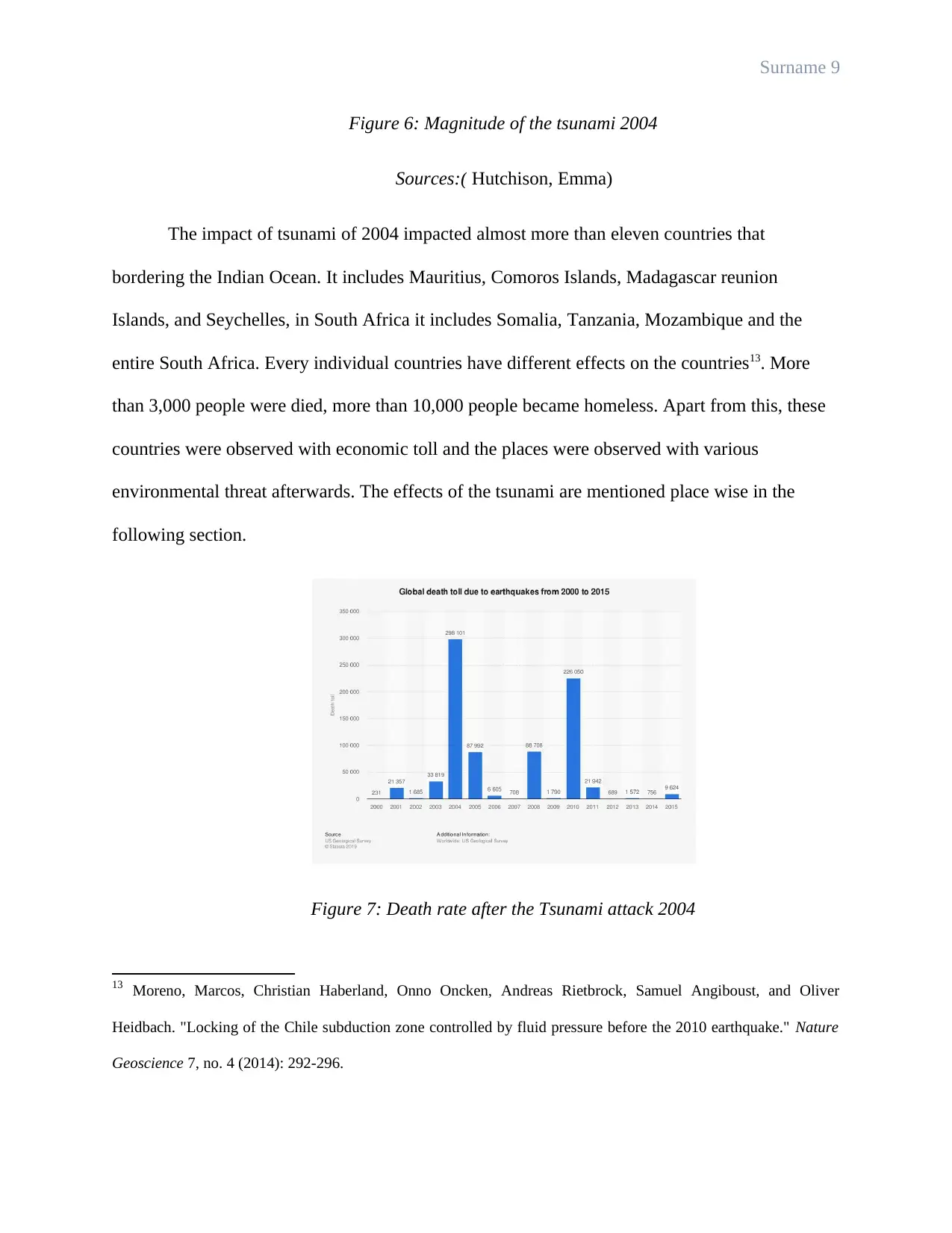
Figure 6: Magnitude of the tsunami 2004
Sources:( Hutchison, Emma)
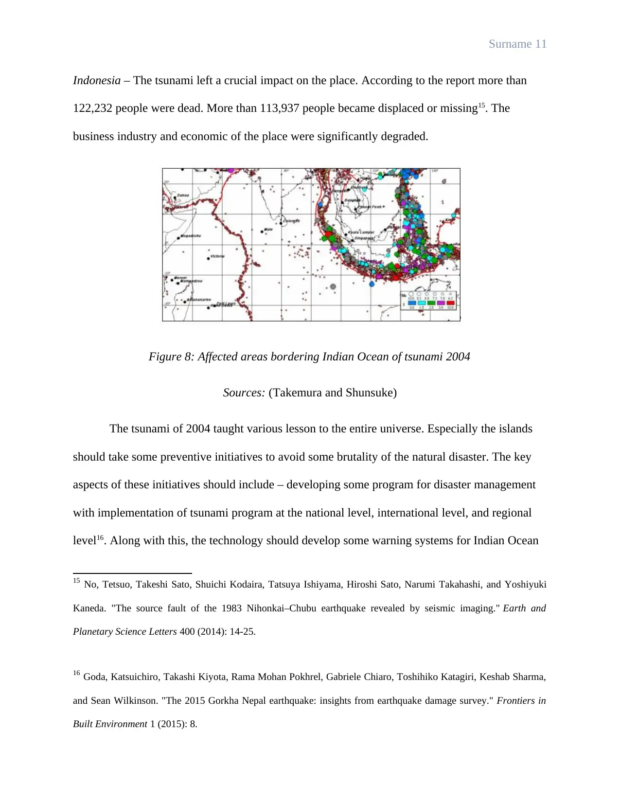
The impact of tsunami of 2004 impacted almost more than eleven countries that
bordering the Indian Ocean. It includes Mauritius, Comoros Islands, Madagascar reunion
Islands, and Seychelles, in South Africa it includes Somalia, Tanzania, Mozambique and the
entire South Africa. Every individual countries have different effects on the countries13. More
than 3,000 people were died, more than 10,000 people became homeless. Apart from this, these
countries were observed with economic toll and the places were observed with various
environmental threat afterwards. The effects of the tsunami are mentioned place wise in the
following section.
Figure 7: Death rate after the Tsunami attack 2004
13 Moreno, Marcos, Christian Haberland, Onno Oncken, Andreas Rietbrock, Samuel Angiboust, and Oliver
Heidbach. "Locking of the Chile subduction zone controlled by fluid pressure before the 2010 earthquake." Nature
Geoscience 7, no. 4 (2014): 292-296.
Paraphrase This Document
Source: (Kristensen et al.)
Mauritius – The huge waves from the ocean submerged the northern village of the island.
However, the news had not reported any death rate in the island. The place was observed with
huge economic loss almost million dollars as per the report.
Madagascar – The height of the waves almost reached 10 meters especially in the south eastern
regions. The number of death was less, and more than 1000 people became homeless. Along
with this, the place was observed with significant economic loss and the corporate industry also
faced severe loss after the hazardous impact of tsunami14.
Reunion Island – The Island was observed with serious economic damages. Especially the
fishing industry was into huge loss after the emergence of the natural disaster.
Seychelles – According to the reports ten people were dead and the flood demolished the
important bridge between the Victoria Port and the main airport. Hence, the impact of the
tsunami resulted into greater economic loss and human loss.
Somalia – According to the report the death rate of the place is quite high that is almost 300
deaths. Along with this, more than 5000 people became homeless after the disaster.
Tanzania – More human loss and economic loss were observed after the hazardous situation.
14 Geersen, Jacob, César R. Ranero, Udo Barckhausen, and Christian Reichert. "Subducting seamounts control
interplate coupling and seismic rupture in the 2014 Iquique earthquake area." Nature communications 6, no. 1
(2015): 1-6.
Indonesia – The tsunami left a crucial impact on the place. According to the report more than
122,232 people were dead. More than 113,937 people became displaced or missing15. The
business industry and economic of the place were significantly degraded.
Figure 8: Affected areas bordering Indian Ocean of tsunami 2004
Sources: (Takemura and Shunsuke)
The tsunami of 2004 taught various lesson to the entire universe. Especially the islands
should take some preventive initiatives to avoid some brutality of the natural disaster. The key
aspects of these initiatives should include – developing some program for disaster management
with implementation of tsunami program at the national level, international level, and regional
level16. Along with this, the technology should develop some warning systems for Indian Ocean
15 No, Tetsuo, Takeshi Sato, Shuichi Kodaira, Tatsuya Ishiyama, Hiroshi Sato, Narumi Takahashi, and Yoshiyuki
Kaneda. "The source fault of the 1983 Nihonkai–Chubu earthquake revealed by seismic imaging." Earth and
Planetary Science Letters 400 (2014): 14-25.
16 Goda, Katsuichiro, Takashi Kiyota, Rama Mohan Pokhrel, Gabriele Chiaro, Toshihiko Katagiri, Keshab Sharma,
and Sean Wilkinson. "The 2015 Gorkha Nepal earthquake: insights from earthquake damage survey." Frontiers in
Built Environment 1 (2015): 8.
⊘ This is a preview!⊘
Do you want full access?
Subscribe today to unlock all pages.

Trusted by 1+ million students worldwide
early tsunamis17. Many of the places are observed with implementation of these procedures for
their countries. For an instance the Madagascar plan of 2006 can be discussed.
The Madagascar plan of 2006 was initiated aiming to the exhaustive nature of the natural
disasters including tsunamis. It incorporated some objectives, which are – development of a
national plan for evacuation on tsunami, preparing an early warning procedure with combination
of the system of the regions, increasing the democratic and social awareness by some training
through the social media and with the regional authorities, construction of demi exercise for
tsunamis, and enhancing the capacity of operational management along with the national
metrological procedure that include warning system of the nation18.
In conclusion, it can be said that, the paper is constructed on the ground of brutal impact
of oceanic earthquake or tsunami of 2004. Natural disasters cannot be avoided and all the nation
should be prepared for the future challenges especially the islands bordering the Indian Ocean
should always be prepared for these natural hazards.
A secondary research methodology has been followed for this assignment. All the
sources are gathered from scholarly articles available on Google Scholar. Key Words used for
the search process are – earthquake, tsunami, cause and effects of oceanic tsunami, Indian Ocean
17 Rubin, Charles M., Benjamin P. Horton, Kerry Sieh, Jessica E. Pilarczyk, Patrick Daly, Nazli Ismail, and Andrew
C. Parnell. "Highly variable recurrence of tsunamis in the 7,400 years before the 2004 Indian Ocean
tsunami." Nature communications 8 (2017): 16019.
18 Prieto, Germán A., Bérénice Froment, Chunquan Yu, Piero Poli, and Rachel Abercrombie. "Earthquake rupture
below the brittle-ductile transition in continental lithospheric mantle." Science advances 3, no. 3 (2017): e1602642.
Paraphrase This Document
tsunami, tsunami 2004, and effects of tsunami. All the information are collected from reliable
sources of the selected articles and research work as mentioned in the bibliography section.
Endnotes
1. Hutchison, Emma. "A global politics of pity? Disaster imagery and the emotional
construction of solidarity after the 2004 Asian tsunami." International Political Sociology 8, no.
1 (2014): 1-19
2. Crooks, A., Croitoru, A., Stefanidis, A. and Radzikowski, J., 2013. # Earthquake:
Twitter as a distributed sensor system. Transactions in GIS, 17(1), pp.124-147.
3. Løvholt, Finn, Neysa J. Setiadi, Joern Birkmann, Carl B. Harbitz, Claudia Bach,
Nishara Fernando, G. Kaiser, and Farrokh Nadim. "Tsunami risk reduction–are we better
prepared today than in 2004?." International journal of disaster risk reduction 10 (2014): 127-
142.
4. Álvarez, Orlando, Silvina Nacif, Mario Gimenez, Andres Folguera, and Carla
Braitenberg. "GOCE derived vertical gravity gradient delineates great earthquake rupture zones
along the Chilean margin." Tectonophysics 622 (2014): 198-215.
5. Takemura, Shunsuke, Takeshi Kimura, Tatsuhiko Saito, Hisahiko Kubo, and
Katsuhiko Shiomi. "Moment tensor inversion of the 2016 southeast offshore Mie earthquake in
the Tonankai region using a three-dimensional velocity structure model: effects of the
accretionary prism and subducting oceanic plate." Earth, Planets and Space 70, no. 1 (2018): 1-
19.
6. Masuti, Sagar, Sylvain D. Barbot, Shun-ichiro Karato, Lujia Feng, and Paramesh
Banerjee. "Upper-mantle water stratification inferred from observations of the 2012 Indian
Ocean earthquake." Nature 538, no. 7625 (2016): 373-377
7. Takewaki, Izuru. Critical excitation methods in earthquake engineering.
Butterworth-Heinemann, 2013.
⊘ This is a preview!⊘
Do you want full access?
Subscribe today to unlock all pages.

Trusted by 1+ million students worldwide
8. Crooks, A., Croitoru, A., Stefanidis, A. and Radzikowski, J., 2013. # Earthquake:
Twitter as a distributed sensor system. Transactions in GIS, 17(1), pp.124-147.
9. Kristensen, P., Weisæth, L., Hussain, A. and Heir, T., 2015. Prevalence of
psychiatric disorders and functional impairment after loss of a family member: A longitudinal
study after the 2004 Tsunami. Depression and anxiety, 32(1), pp.49-56.
10. Miyazawa, Yasumasa, Nobuyoshi Yamashita, Sachi Taniyasu, Eriko Yamazaki,
Xinyu Guo, Sergey M. Varlamov, and Toru Miyama. "Oceanic dispersion simulation of
perfluoroalkyl substances in the Western North Pacific associated with the Great East Japan
Earthquake of 2011." Journal of oceanography 70, no. 6 (2014): 535-547.
11. Griffin, Christina, David Ellis, Sara Beavis, and Doracie Zoleta-Nantes. "Coastal
resources, livelihoods and the 2004 Indian Ocean tsunami in Aceh, Indonesia." Ocean & coastal
management 71 (2013): 176-186
12. Moreno, Marcos, Christian Haberland, Onno Oncken, Andreas Rietbrock,
Samuel Angiboust, and Oliver Heidbach. "Locking of the Chile subduction zone controlled by
fluid pressure before the 2010 earthquake." Nature Geoscience 7, no. 4 (2014): 292-296.
13. Geersen, Jacob, César R. Ranero, Udo Barckhausen, and Christian Reichert.
"Subducting seamounts control interplate coupling and seismic rupture in the 2014 Iquique
earthquake area." Nature communications 6, no. 1 (2015): 1-6.
14. No, Tetsuo, Takeshi Sato, Shuichi Kodaira, Tatsuya Ishiyama, Hiroshi Sato,
Narumi Takahashi, and Yoshiyuki Kaneda. "The source fault of the 1983 Nihonkai–Chubu
earthquake revealed by seismic imaging." Earth and Planetary Science Letters 400 (2014): 14-
25.
Paraphrase This Document
15. Goda, Katsuichiro, Takashi Kiyota, Rama Mohan Pokhrel, Gabriele Chiaro,
Toshihiko Katagiri, Keshab Sharma, and Sean Wilkinson. "The 2015 Gorkha Nepal earthquake:
insights from earthquake damage survey." Frontiers in Built Environment 1 (2015): 8.
16. Rubin, Charles M., Benjamin P. Horton, Kerry Sieh, Jessica E. Pilarczyk, Patrick
Daly, Nazli Ismail, and Andrew C. Parnell. "Highly variable recurrence of tsunamis in the 7,400
years before the 2004 Indian Ocean tsunami." Nature communications 8 (2017): 16019.
17. Prieto, Germán A., Bérénice Froment, Chunquan Yu, Piero Poli, and Rachel
Abercrombie. "Earthquake rupture below the brittle-ductile transition in continental lithospheric
mantle." Science advances 3, no. 3 (2017): e1602642.
Bibbliography
Documents
Álvarez, Orlando, Silvina Nacif, Mario Gimenez, Andres Folguera, and Carla Braitenberg.
"GOCE derived vertical gravity gradient delineates great earthquake rupture zones along
the Chilean margin." Tectonophysics 622 (2014): 198-215.
Crooks, A., Croitoru, A., Stefanidis, A. and Radzikowski, J., 2013. # Earthquake: Twitter as a
distributed sensor system. Transactions in GIS, 17(1), pp.124-147.
Geersen, Jacob, César R. Ranero, Udo Barckhausen, and Christian Reichert. "Subducting
seamounts control interplate coupling and seismic rupture in the 2014 Iquique earthquake
area." Nature communications 6, no. 1 (2015): 1-6.
Griffin, Christina, David Ellis, Sara Beavis, and Doracie Zoleta-Nantes. "Coastal resources,
livelihoods and the 2004 Indian Ocean tsunami in Aceh, Indonesia." Ocean & coastal
management 71 (2013): 176-186.
Hutchison, Emma. "A global politics of pity? Disaster imagery and the emotional construction of
solidarity after the 2004 Asian tsunami." International Political Sociology 8, no. 1
(2014): 1-19.
Kristensen, P., Weisæth, L., Hussain, A. and Heir, T., 2015. Prevalence of psychiatric disorders
and functional impairment after loss of a family member: A longitudinal study after the
2004 Tsunami. Depression and anxiety, 32(1), pp.49-56.
Løvholt, Finn, Neysa J. Setiadi, Joern Birkmann, Carl B. Harbitz, Claudia Bach, Nishara
Fernando, G. Kaiser, and Farrokh Nadim. "Tsunami risk reduction–are we better
⊘ This is a preview!⊘
Do you want full access?
Subscribe today to unlock all pages.

Trusted by 1+ million students worldwide
prepared today than in 2004?." International journal of disaster risk reduction 10 (2014):
127-142.
Masuti, Sagar, Sylvain D. Barbot, Shun-ichiro Karato, Lujia Feng, and Paramesh Banerjee.
"Upper-mantle water stratification inferred from observations of the 2012 Indian Ocean
earthquake." Nature 538, no. 7625 (2016): 373-377.
Miyazawa, Yasumasa, Nobuyoshi Yamashita, Sachi Taniyasu, Eriko Yamazaki, Xinyu Guo,
Sergey M. Varlamov, and Toru Miyama. "Oceanic dispersion simulation of
perfluoroalkyl substances in the Western North Pacific associated with the Great East
Japan Earthquake of 2011." Journal of oceanography 70, no. 6 (2014): 535-547.
Moreno, Marcos, Christian Haberland, Onno Oncken, Andreas Rietbrock, Samuel Angiboust,
and Oliver Heidbach. "Locking of the Chile subduction zone controlled by fluid pressure
before the 2010 earthquake." Nature Geoscience 7, no. 4 (2014): 292-296.
No, Tetsuo, Takeshi Sato, Shuichi Kodaira, Tatsuya Ishiyama, Hiroshi Sato, Narumi Takahashi,
and Yoshiyuki Kaneda. "The source fault of the 1983 Nihonkai–Chubu earthquake
revealed by seismic imaging." Earth and Planetary Science Letters 400 (2014): 14-25.
Puthezhath, ARJUN S. "Identification of thermal fronts in the Arabian sea using MODIS-SST
data." Kerala University Of Fisheries And Ocean Studies. Panangad (2014).
Takemura, Shunsuke, Takeshi Kimura, Tatsuhiko Saito, Hisahiko Kubo, and Katsuhiko Shiomi.
"Moment tensor inversion of the 2016 southeast offshore Mie earthquake in the Tonankai
region using a three-dimensional velocity structure model: effects of the accretionary
prism and subducting oceanic plate." Earth, Planets and Space 70, no. 1 (2018): 1-19.
Paraphrase This Document
Takewaki, Izuru. Critical excitation methods in earthquake engineering. Butterworth-
Heinemann, 2013.
Non-writers
Goda, Katsuichiro, Takashi Kiyota, Rama Mohan Pokhrel, Gabriele Chiaro, Toshihiko Katagiri,
Keshab Sharma, and Sean Wilkinson. "The 2015 Gorkha Nepal earthquake: insights from
earthquake damage survey." Frontiers in Built Environment 1 (2015): 8.
Prieto, Germán A., Bérénice Froment, Chunquan Yu, Piero Poli, and Rachel Abercrombie.
"Earthquake rupture below the brittle-ductile transition in continental lithospheric
mantle." Science advances 3, no. 3 (2017): e1602642.
Rubin, Charles M., Benjamin P. Horton, Kerry Sieh, Jessica E. Pilarczyk, Patrick Daly, Nazli
Ismail, and Andrew C. Parnell. "Highly variable recurrence of tsunamis in the 7,400
years before the 2004 Indian Ocean tsunami." Nature communications 8 (2017): 16019.
Your All-in-One AI-Powered Toolkit for Academic Success.
+13062052269
info@desklib.com
Available 24*7 on WhatsApp / Email
![[object Object]](/_next/static/media/star-bottom.7253800d.svg)
© 2024 | Zucol Services PVT LTD | All rights reserved.

