EG7013 Transportation Engineering Report: Site Analysis in London
VerifiedAdded on 2022/11/28
|22
|3911
|93
Report
AI Summary
This report, prepared for TransEng Ltd, analyzes the transportation-related issues of a proposed residential estate development in Central London. The study begins with an introduction to the growth and infrastructure demands of London, emphasizing the need for multimodal transport solutions. It outlines national, regional, and local policy directions, highlighting the development of multimodal analysis tools. The report assesses the existing public transport provision, including highway networks, residential, commercial, and other land uses. It utilizes the Real Accessibility Index (RAI) to evaluate pedestrian friendliness and analyzes trip generation and traffic assignment, with assumptions and calculations based on vehicular traffic data. The report also addresses enhancing safety and security for pedestrians, relevant parking, and cycling policies. The report concludes by discussing the importance of making the area more pedestrian-friendly, outlining strategies for achieving this goal. The report provides a detailed analysis of transportation challenges and offers recommendations for improving traffic flow, pedestrian safety, and the integration of various transport modes within the development.
TRANSPORTATION ENGINEERING
By Name
Course
Instructor
Institution
Location
Date
1
By Name
Course
Instructor
Institution
Location
Date
1
Paraphrase This Document
Need a fresh take? Get an instant paraphrase of this document with our AI Paraphraser
INTRODUCTION
London has been regarded as one of the fastest growing cities in the UK. It attracts a very
significant number of visitors annually. The city is actually expected to continue growing an
expected population growth of more than 8 million by the year 2030. Such kind of the fast
growth and development place substantial demand on the infrastructure of London as well as the
needs for funding of capacity improvements and new Highways.It has been discovered that it is
not possible to build one way out of congestion1. The methods such as the increase of the ability
to effectively operate and manage the system, demand reduction through better coordination of
transportation as well as providing the travelers with the choice to use alternative modes of
transport have been taken to be the main themes of London Transportation Plan.
Outlines of the relevant transport related national, regional and local policy
Directions for future multimodal Work
In regard to this particular requirement, London has made very important signs of progress as far
as the development of tools is concerned for the analysis of the multimodal. However, there are
additional opportunities which can be exploited for further development of the same tools. As
will be seen in this particular project, there is the existence of most of the approaches both
regionally and nationally. These approaches can be used effectively in the enhancement of the
multimodal tool to be used in London. The development of such tools will be done in a manner
considered to be inconsistent with the constraints as well as opportunities with the environment
of transportation and planning in London. The study has therefore identified further research that
has been based on the findings which had been revealed initially. It starts with the identification
1 Anable, J., Brand, C., Tran, M. and Eyre, N., 2012. Modeling transport energy demand: A socio-technical approach. Energy policy, 41, pp.125-
138
2
of the general approach besides the multimodal research before detailed ideas of the research can
be identified. There is recognition for additional data collection as an identified need.
Appraisal Work
In this project, there is the outline of various factors or questions which London Department of
Transportation should put into consideration while deciding on the mechanism of the
incorporation of multimodal tradeoff analysis into the transportation analysis tools in existence in
London2. Although the paper or the project does not anticipate how any of the specific questions
will be answered in details, the recommendations provided by the paper are built based on the
approach recommended to the analysis of multimodal tradeoff. The appraisal thus addresses two
aspects of multimodal tradeoff analysis including approaches to the analysis and scope of the
analysis.
Description of existing public transport provision in the area near the site including
highway networks, locations of residential, commercial and other land uses
As defined currently, the MMTD should at least have a minimum of 25000 m2 and 15oo
residential units. If taken that the area is almost 2 square miles and the population to be averagely
5000, the population to job ratio will be equivalent to 1:2. It will be responsible for the provision
of the transit service as well as facilitate connectivity of the pedestrians which would imply 50
polygons for every square mile3. The approximate mix use of the land will significantly be three
including the establishment of retail offices, hotel/motel/ residential, cultural, recreational and
entertainment that is mutually supporting. It will go alongside intergradation of the components
2 Batty, M., 2013. Big data, smart cities and city planning. Dialogues in Human Geography, 3(3), pp.274-279
3 Finetti, F., Patrussi, L., Masi, G., Onnis, A., Galgano, D., Lucherini, O.M., Pazour, G.J. and Baldari, C.T., 2014. Specific recycling receptors are
targeted to the immune synapse by the intraflagellar transport system. J Cell Sci, 127(9), pp.1924-1937
3
⊘ This is a preview!⊘
Do you want full access?
Subscribe today to unlock all pages.

Trusted by 1+ million students worldwide
of the project like continuous as well as connected facilities of the pedestrian. Taking arbitrarily
the employment within a region to be 1500
A total residential unit within the same area as 1500
Defined area total employment 750
Total residential unit in the specified defined area is 750
% of employment =50%
% of house hold=50%
Assessment Tools for Development of Regional Impact
The first part of the appraisal seeks to address the concern that the analysis of MMTDs is based
upon an assessment of the areas which are perceived to be having more accessibility4.
Real Accessibility Index
It is commonly referred to as RAI. This is the best way of evaluating the level of pedestrian
friendliness. There should be choosing the specific neighborhoods so that they can be scored as
per the point scale. The area will be visually evaluated as per the criteria of scoring with data is
gathered. The areas are therefore given points based on the accessibility of various travel modes
as well as the connection between residential areas and the commercial service centers. The
higher score will represent a higher number of available options in the area.
4 Geels, F.W., 2012. A sociotechnical analysis of low-carbon transitions: introducing the multi-level perspective into transport studies. Journal of
transport geography, 24, pp.471-482.
4
Paraphrase This Document
Need a fresh take? Get an instant paraphrase of this document with our AI Paraphraser

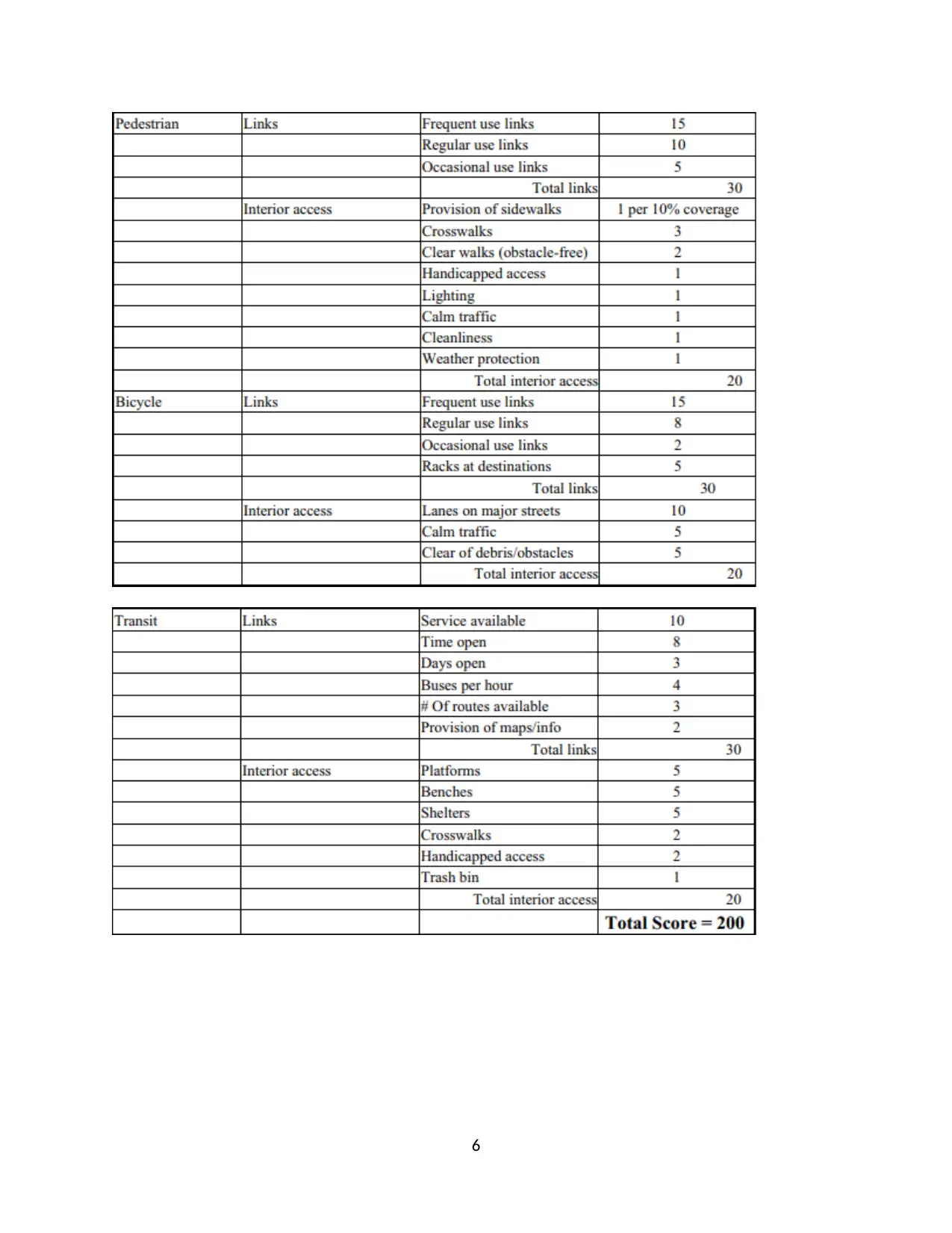
The study has therefore proposed the use of RAI which is based on the points of linkages as well
as points of the interior accessibility. There is awarding of the linkage points for every mode in
case the residents of the neighborhood are capable of effectively reaching out to the services by
the use a specific type of such kind of the transport mode. In order to score the interior
accessibility, there will be the determination of the chances of a resident traveling with a lot of
ease within a particular area. The existence of right-of-way for every mode and its conditions are
reflected by the scores in every category. The factors of the pedestrian friendliness will be scored
as in consideration with cleanliness, safety, weather protection and finally lighting. The scoring
as per the area of the study is as indicated in the table below
5
6
⊘ This is a preview!⊘
Do you want full access?
Subscribe today to unlock all pages.

Trusted by 1+ million students worldwide
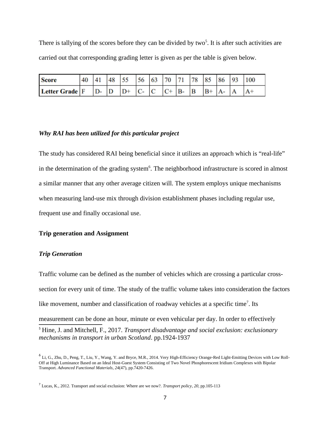
There is tallying of the scores before they can be divided by two5. It is after such activities are
carried out that corresponding grading letter is given as per the table is given below.
Why RAI has been utilized for this particular project
The study has considered RAI being beneficial since it utilizes an approach which is “real-life”
in the determination of the grading system6. The neighborhood infrastructure is scored in almost
a similar manner that any other average citizen will. The system employs unique mechanisms
when measuring land-use mix through division establishment phases including regular use,
frequent use and finally occasional use.
Trip generation and Assignment
Trip Generation
Traffic volume can be defined as the number of vehicles which are crossing a particular cross-
section for every unit of time. The study of the traffic volume takes into consideration the factors
like movement, number and classification of roadway vehicles at a specific time7. Its
measurement can be done an hour, minute or even vehicular per day. In order to effectively
5 Hine, J. and Mitchell, F., 2017. Transport disadvantage and social exclusion: exclusionary
mechanisms in transport in urban Scotland. pp.1924-1937
6 Li, G., Zhu, D., Peng, T., Liu, Y., Wang, Y. and Bryce, M.R., 2014. Very High-Efficiency Orange‐Red Light‐Emitting Devices with Low Roll‐
Off at High Luminance Based on an Ideal Host-Guest System Consisting of Two Novel Phosphorescent Iridium Complexes with Bipolar
Transport. Advanced Functional Materials, 24(47), pp.7420-7426.
7 Lucas, K., 2012. Transport and social exclusion: Where are we now?. Transport policy, 20, pp.105-113
7
Paraphrase This Document
Need a fresh take? Get an instant paraphrase of this document with our AI Paraphraser
determine the required flow rate, it is necessary to convert the flow of the vehicles into other
standard aspects. It becomes very complex the effectively calculate the capacity that is usually
considered to be the fundamental basis for the design, layout, planning as well as the highways
and roads. This implies that the precise vehicle integration and evaluation becomes the
prerequisite fundamental for road capacity determination.
Assumptions and Calculation
It can be assumed that the data was collected at the peak hours during the weekdays at Vehicular
traffic (2-way) on the two roads are 20,000 veh/day and 12,000 veh/day for EW and NS roads,
respectively. The best option for the collection of this kind of data will be Videography since it
requires very little manpower. The classification of the vehicles was categorized as two-wheeler,
three-wheeler, LCV, truck, bus, car, cycle rickshaw, and cycle.The mounting of the recording
video begun in the morning.
8
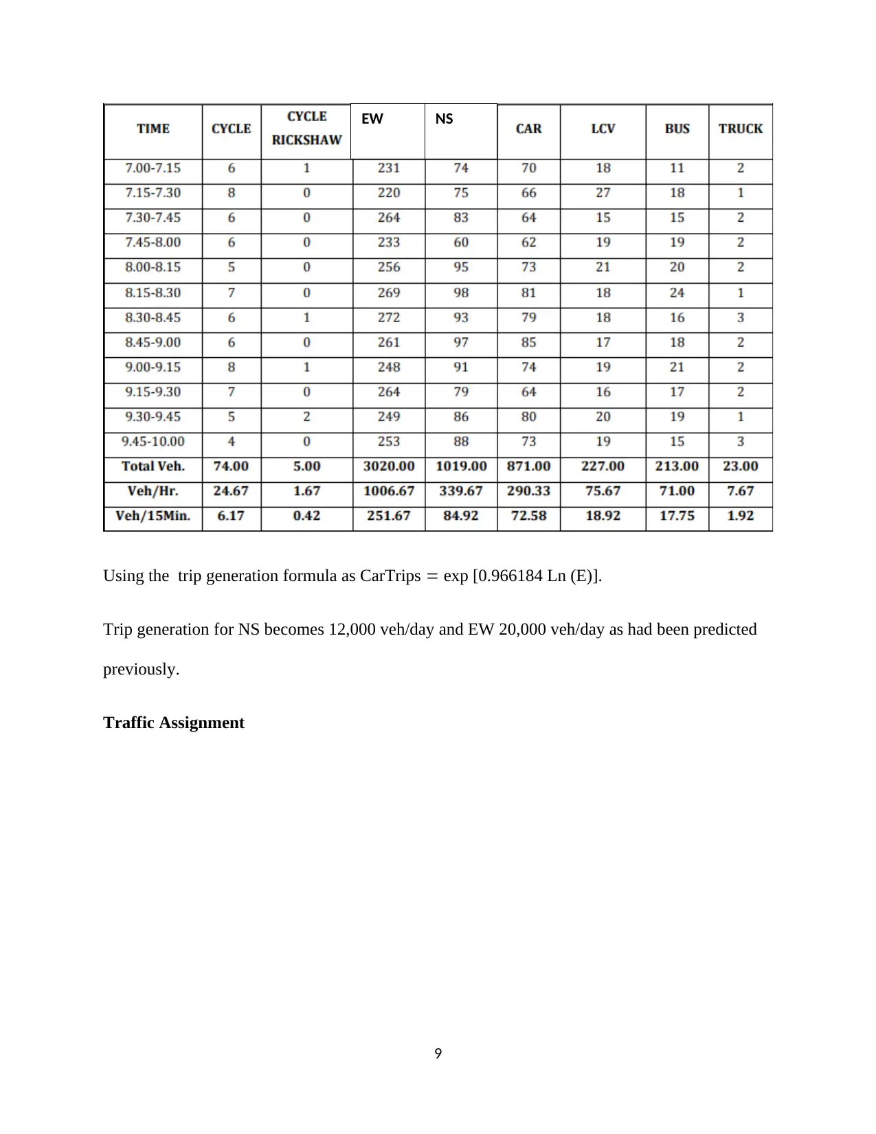
Using the trip generation formula as CarTrips exp [0.966184 Ln (E)].
Trip generation for NS becomes 12,000 veh/day and EW 20,000 veh/day as had been predicted
previously.
Traffic Assignment
9
EW NS
Trip generation for NS becomes 12,000 veh/day and EW 20,000 veh/day as had been predicted
previously.
Traffic Assignment
9
EW NS
⊘ This is a preview!⊘
Do you want full access?
Subscribe today to unlock all pages.

Trusted by 1+ million students worldwide
Enhancing Safety and Security
The person on foot wellbeing configuration must be the prime goal of person on foot foundation.
The person on foot vehicular clashes must have stayed away from8. The following scenarios
were identified by TransEng Ltd:
• A place to walk is missing from significant passerby zones. These territories ought to be given
walkways, and with least standard structure contemplations. The walkways ought to stay away
from any blocks, obstructions and a lot of level contrast to be accommodated open to strolling
space.
• The barrier-free person on foot foundation configuration approach is required for walkway
configuration which considers the security for crippled, elderly and additionally kids. Safe street
crossing foundation is required particularly for real work furthermore, business focuses of the
city for safe walker development. Subsequently relying upon a number of footfalls crossing the
8 Rajé, F., 2017. Negotiating the transport system: user contexts, experiences, and needs. 96(12),
pp.2059-2077.
10
Paraphrase This Document
Need a fresh take? Get an instant paraphrase of this document with our AI Paraphraser
roads skywalks furthermore, trams must be proposed to maintain a strategic distance from the
pedestrian vehicular clash.
Relevant parking, pedestrian and cycling policies
The availability, as well as the price for parking, has been viewed as a vital factor of
consideration in the attempt of applying new transportation modes. The choice of transportation
mode is greatly influenced by the parking price either high or constrained more so in the
presence of other modes of transport. MMTDs is purposefully to support the use of other modes
of transport rather than the automobile9. However, Area-wide Level of Service Handbook as well
as MMTDs has incorporated neither pricing nor regulations on the available parking into the
planning and analysis processes.
The project demonstrates an early research activity conducted together with recommendations on
the findings pertaining to connectivity on the choice of transportation mode and installation of
the policies of parking to the analysis of both multimodal tradeoff and MMTDs. The project at
the same time will identify as well as review successful parking techniques like the price of
parking, shared parking and also replacements for the minimum standards to aid planning
support on multimodal and for possible applications on the analysis of multimodal in London.
Generating cycling and the walking nation refers to a continuous process that takes a number of
time and requires strategy as the initial step. The estimated ambition for the year 2040 stands to
be cycling and walking as an everyday part of the activity as well as the choice by nature for
9 Sato, T., Niita, K., Matsuda, N., Hashimoto, S., Iwamoto, Y., Noda, S., Ogawa, T., Iwase, H.,
Nakashima, H., Fukahori, T. and Okumura, K., 2013. Particle and heavy ion transport code
system, PHITS, version 2.52. Journal of Nuclear Science and Technology, 50(9), pp.913-923.
11

short distance walks like trekking to the workplace, school, college or just leisure trips. There is
a need to create a nation in which cycling, as well as walking, forms the main part of activity
practiced by people regardless of their features or historical backgrounds. To successfully
achieve the goal, each and every individual residing within the country has to get access to
reliable, gorgeous walking and cycling paths. This goal is what is referred to like walking and
cycling ambition, which is "making walking as well as cycling as a choice by nature to cover
short distance walks or to cover partly a long distance walk"
Making the area more pedestrian friendly
In order to achieve this; the following steps will be followed:
Definition of major modal facilities
Establishment of the user areas of service by mode
12
⊘ This is a preview!⊘
Do you want full access?
Subscribe today to unlock all pages.

Trusted by 1+ million students worldwide
1 out of 22
Related Documents
Your All-in-One AI-Powered Toolkit for Academic Success.
+13062052269
info@desklib.com
Available 24*7 on WhatsApp / Email
![[object Object]](/_next/static/media/star-bottom.7253800d.svg)
Unlock your academic potential
Copyright © 2020–2026 A2Z Services. All Rights Reserved. Developed and managed by ZUCOL.


