SINGNIFICANCE OF URBAN & REGIONAL PLANNING
VerifiedAdded on 2022/09/09
|19
|5068
|12
AI Summary
Contribute Materials
Your contribution can guide someone’s learning journey. Share your
documents today.
URBAN & REGIONAL PLANNING
By Name
Course
Instructor
Institution
Location
Date
By Name
Course
Instructor
Institution
Location
Date
Secure Best Marks with AI Grader
Need help grading? Try our AI Grader for instant feedback on your assignments.
Contents
Land Information Systems/Land Use and Management Information Systems............................................3
Definition.................................................................................................................................................3
Benefits of Land Information Systems.....................................................................................................4
Components of Land Information Systems..............................................................................................6
Stakeholders of Land Information Systems.............................................................................................6
Conceptual Framework for Land Information System in Saudi Arabia....................................................7
Zoning regulations in Saudi Arabia............................................................................................................11
Development Control System in the United Kingdom...............................................................................13
Urban regenerative initiatives and practices in Saudi Arabia & potential improvements.........................14
References.................................................................................................................................................16
Land Information Systems/Land Use and Management Information
Systems
Definition
A Land Information System defines a Geographic Information System mainly used for cadastral
as well as land use mapping basically composed of an accurate, reliable as well as current land
record cadastre and accompanying tributes. A Land Information System is composed of spatial
data which are representative of the legal jurisdictions of land tenure and offers a vital base layer
for the purposes of integration into other spatial data or information systems deemed to be of
importance or even as a standalone approaches which allow users to extract, create, store, access,
update, evaluate as well as publish information regarding land (Zeng and Cleon, 2018).
As per International Federal of Surveyors, a Land Information System is described as a tool used
for the purposes of legal, economic as well as administrative decision-making as well as an aid
for development and planning purposes. Land information is composed of a database that bears
spatially referenced as well as non-spatial data associated with land for a given region on one
hand and the processes as well as methods used in the scientific collection, processing, updating
as well as distribution off data on the other hand (Wahid, Sæbø and Furuholt, 2017).
In the perspective of common law, the application of the term land in a given parcel defines the
surface of the earth, the air column above such surface as well as the soil below the surface
running all the way to the Earth center. It is inclusive of all things that grow on or even affixed to
soil including but not limited to buildings tresses as well as crops. It is as well included any
minerals of the soil excluding silver and gold which are of the Crown as royal metals at law.
A cadastre defines a land information system that is up to date and parcel based and is composed
of a record of the various interest in land for instance responsibilities, rights as well as
restrictions. It is often inclusive of a geometric description of the different land parcels
associated with other records that describe the nature of ownership, interests or even control of
such interests and in most cases the parcel value and its enhancements (Hallett et al., 2017). It
can be developed for fiscal purposes including taxation as well as valuation, legal functions
among the conveyance, control of land use including panning alongside administration as well as
to aid in land management and allows sustainable development alongside improvement of the
environment.
Land Information Systems are often map based and tend to provided numerous real benefits to
an avalanche of organizations and firms:
Land owners among them managers of estates, government authorities as well as agri
business cooperatives
Natural resource use industries among them extraction companies, forestry alongside
wind energy companies (Dawidowicz and Źróbek, 2017)
Local as well as central governments that need accurate and reliable land and
construction use inventories
Benefits of Land Information Systems
Reducing risks: Changing and retaining data on land parcels, production, ownership utility, uses
among others in digital formats tends to offer safety to a large extent from possible damages or
even loss
Increased efficiency of use of resource: Information that is more useful in the support of
decision making as well as tracking is generation by having in place collated available data and
Secure Best Marks with AI Grader
Need help grading? Try our AI Grader for instant feedback on your assignments.
integration of the data with associated data topics as well as layers. The overall effect of this is
enhancement of the efficiency in the use of all land resources that are available. For instance,
building as well as land leasing alongside rental, planning for agribusiness are all beneficiaries of
the implementation of Land Information System (Latu and Dacey, 2018)
Reporting and Analysis: Banking on the integration of the relevance as well as required data
alongside the use of major map layers including transport and topography, a possibility is created
for modelling as well as analysing the various land use scenarios among them:
Extraction of minerals
Location of wind turbines
Run-off of nutrients
Wind throw hazard of forestry
Harvesting as well as planning of agriculture and forestry; and
Valuation as well as usage of buildings
Information access and sharing: Chances of sharing information and data alongside the
outcomes of various evaluations to a great extent are increased with an access to integrated
holdings of data that are augmented by mapping information systems. The use of mobile
platforms or even web-based platforms enable wide sharing as well as access to information in
an office, on site or even in the field. A combination of the mapping power with creation of
report makes raw data become highly valuable information that may be delivered in a form that
is not only interpretable but also accessible for numerous and various users and uses (Lubis et al.,
2017).
Components of Land Information Systems
A typical Land Information System is:
Hard copy maps alongside GIS or even CAD software that are majorly used for spatial
representation
Parcel oriented
Has cadastre as the primary or major component
Maintained by the available unit of authority or government that is mandated with land
ownership as well as tracking, control in most cases the county government
Relatively large scale (cartographic) for instance for the case of rural areas might be
1:4800 and may be to 1:1200 for the case or cities or developed regions
Acts as a bridge between the legal for instance deeds and technical land descriptions
including GIS coordinates and maps (Land, 2018)
May be inclusive of other technologies including parcel index systems which are
relational data base management systems
Surveying; and
Document as well as fiche imaging systems
Stakeholders of Land Information Systems
Personal applicants
Professional users
Genealogical or historical researchers
Licenced conveyors
Financial institutions or banks
Citizens planning to develop property information
Information providers on re-use of public secto
Conceptual Framework for Land Information System in Saudi Arabia
A multipurpose land information system is the conceptual framework suggested and perceived to
be most appropriate for enhancing the land information of Saudi Arabia. A few of the elementary
information regarding land much of what would like to be included by the local authorities as
well as municipalities in a multipurpose land information system are regards land interests
(Yomralioglu and McLaughlin, 2017). Issues bordering on ownership, political jurisdictions,
rights of way, zoning as well as taxation are all illustrations of legal interest in land which are
described in terms of degree and nature.
The nature of an interest in land in Saudi Arabia is defined with regards to the restrictions as well
as rights that influence the land use alongside its resources even as the extent or degree defines
the boundaries of such interests and the resources. Such land interests have undergone evolution
over the time and have defined the land records systems of the country hence availing an
effective as well as efficient data information regarding land is of importance for a given land
management dealing within the country (Rakhmanov, 2019).
A Land Information System offers an effective system which provided precise as well as
accurate information for holders alongside users of a given interest in land holding the fact the
land property is a very complex as well as dynamic collection of interests or even rights. An
individual may have the rights to use the surface of the land, while another might exploit the
minerals beneath, another mortgage even as another lease (El-Ayachi, 2017). Above such
interests are the public interests including right to tax, right of eminent, navigate as well as the
Paraphrase This Document
Need a fresh take? Get an instant paraphrase of this document with our AI Paraphraser
powers and rights to limit land use in a bid to safeguard the common welfare, safety as well as
health i.e. public good.
As a result of such sophisticated relationships, a multipurpose land information system is what is
required to sort out the multifarious problems of land administration that currently face Saudi
Arabia. The existing system is overwhelmed with defects as a result of high levels of
mishandling of land information as well as corrupt dealings within the public sector especially
Department of Lands and Physical Planning. Should the right system be adopted in Saudi Arabia,
it is anticipated that issues including land grabbing would not have been as common as what can
be noted in the system of today.
A multipurpose land information system having a carefully thought out and integrated
framework is integral in attaining effective data management of land information. This would aid
is efficient land management systems which is not only affordable but also highly accessible to
the holders as well as users of a given land interest besides the interested general public who
would like to make inquiries on such information (Khezri, 2019). A properly integrated system
also aids in resolving among them common land disputes besides enhancing technicalities in
their effective solution.
Nevertheless, updating regularly in keeping the framework as well further promotes more
efficient and effective use of the system. The proposed system, thus, will be an electronic filing
system which would be better accommodative of all the needed land information data which are
of importance for any deemed purpose (Al-Ghanmi and Al-Jabri, 2019). The system will be very
accurate to the extent it will be in apposition to offer lot number, registration, amenities,
subdivision as well as legal interest in land for instance supply of water, electricity alongside
other required information that will be deemed importance when offering description to a given
land or real property. A research into the current land information system used in Saudi Arabia
reveals most of the current data on land information system is still held in the conventional paper
filing system; a method that takes relatively long time with processing and retrieval of
information should there need be (Kariuki, Karugu and Opiyo, 2018). Paper filing system is
normally susceptible to manipulation that thereafter results in corruption and malpractices.
Nevertheless, the Department of Lands and physical Planning is ever working on better
approaches in filing system for instance the one adopted for property taxation and rating by the
local authorities in the developed countries with the expectation of lowering the level of
malpractices. A recent research established that the Department of Lands and Physical Planning
adopted the Land Information System before replacing it with Land Acquisition Geographical
Information System (Adad, 2019). The suggested multipurpose land information system is
however considered to be far better than Land Acquisition Geographical Information System as
it offer more elaborate information in comparison with Land Acquisition Geographical
Information System.
It is of importance to have an understanding of the structure of the organization of Saudi
Arabia’s National Department of Lands and Physical Planning at this point. A comprehension of
the entire structure would aid in the integration of the data needed for the whole organization as
well as the users of real estate alongside stakeholders within the real estate industry (Akeh and
Mshelia, 2016). The chart below is an illustration of the structure of the organization which
might be applicable as the pedestal for the design of the proposed multipurpose land information
system.
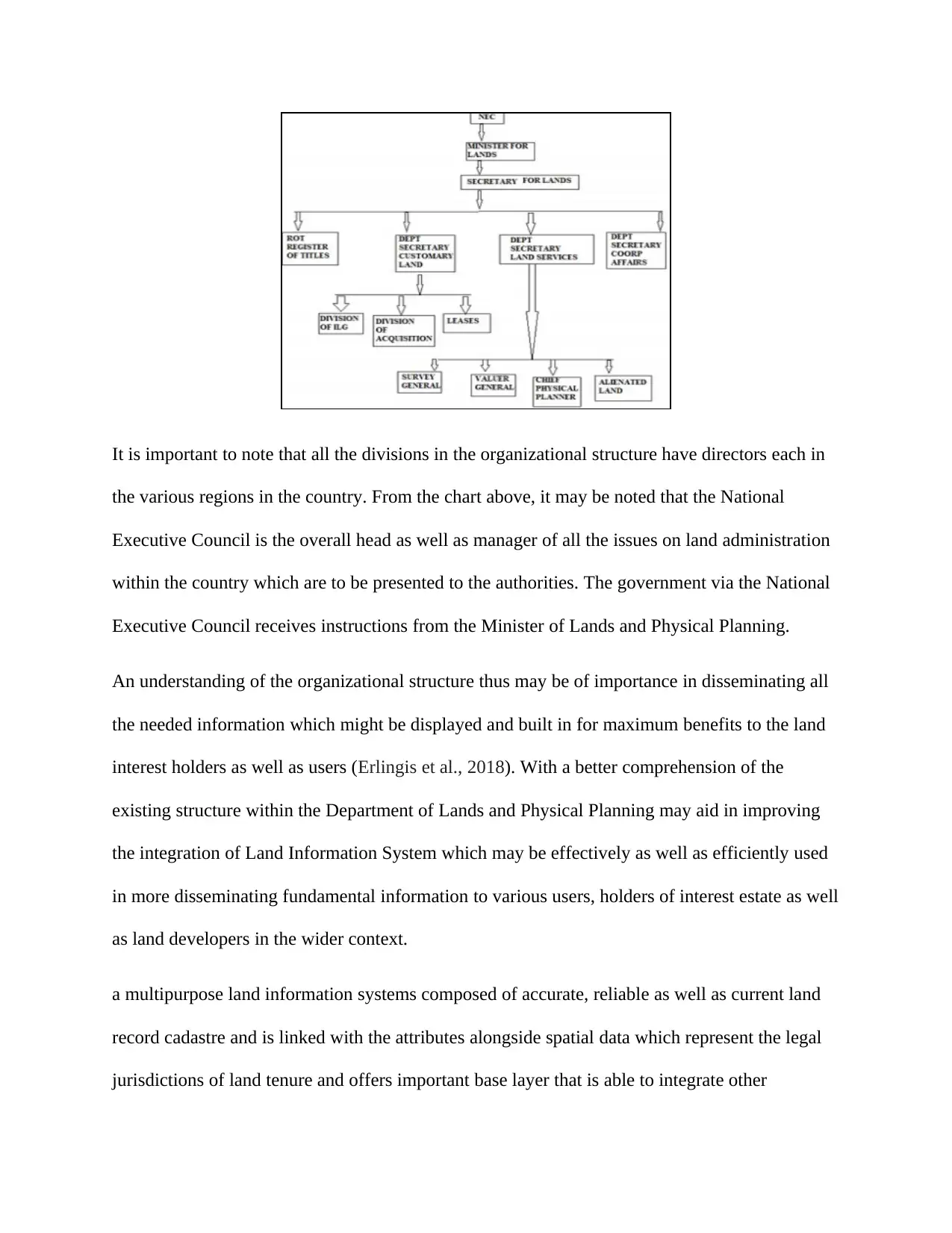
It is important to note that all the divisions in the organizational structure have directors each in
the various regions in the country. From the chart above, it may be noted that the National
Executive Council is the overall head as well as manager of all the issues on land administration
within the country which are to be presented to the authorities. The government via the National
Executive Council receives instructions from the Minister of Lands and Physical Planning.
An understanding of the organizational structure thus may be of importance in disseminating all
the needed information which might be displayed and built in for maximum benefits to the land
interest holders as well as users (Erlingis et al., 2018). With a better comprehension of the
existing structure within the Department of Lands and Physical Planning may aid in improving
the integration of Land Information System which may be effectively as well as efficiently used
in more disseminating fundamental information to various users, holders of interest estate as well
as land developers in the wider context.
a multipurpose land information systems composed of accurate, reliable as well as current land
record cadastre and is linked with the attributes alongside spatial data which represent the legal
jurisdictions of land tenure and offers important base layer that is able to integrate other
Secure Best Marks with AI Grader
Need help grading? Try our AI Grader for instant feedback on your assignments.
geographic systems or even as independent solution which enable updating, storage, creation,
viewing, evaluation and publishing of data land information to the possible clients for use in
advertising.
Basic information disseminated via the use of land information system data base ought to be
inclusive of land parcels that are the basic access as well as control units of land besides land-use
decisions (Bahremand, Onagh and Komaki, 2018). Others are inclusive of land planning,
maintenance as well as development of infrastructure, economic development as well as social
service programs. Still, appropriate research besides proper review reforms alongside policies
have to be established.
A proper and well-choreographed database for multipurpose land information system allows the
land reforms as well as policies that encompass putting in place appropriate laws for correction
of the mistakes or flaws which lead to corrupt practices and abuse of procedures in land
administration and management (Bahremand, Onagh and Komaki, 2018).
Zoning regulations in Saudi Arabia
Zoning defines the division of a region into sub-regions for the reasons of properly and
adequately controlling the use of land. In most cases, such sub-regions are established by
regulations as a segment of a local city plan and demonstrated on a zoning map. The zoning
regulations that are adopted in Saudi Arabia currently are more of deterministic fixed controls
kind and are inclusive of regulations touching on setbacks and heights of buildings among others
(Qurnfulah and Isah, 2019).
Most of the modern settlements of the country have been erected under such regulations. In some
unfortunate case, strict observance of the requirements has resulted in some challenges. Some of
these challenges result from the fact that the regulations are not ever in line with the socio-
cultural norms and still, there tend to be failure to take into consideration the arid climate, high
costs of development and maintenance, inefficient utilization of land besides negative
psychological as well as health impacts on the dwellers in some instances as a result of the
regulations (Hassanain, Hamwda and Sanni-Anibire, 2018). Privacy alongside community is
among the key issues that have to be looked into when coming up with zoning regulations that
can be applied in Saudi Arabia. With some of the modifications being fixed, seemingly zoning
regulations tend to be most ideal in satisfying the elementary objectives of protection of privacy.
Nevertheless, there is as well an imperative need of bringing some level of flexibility into the
current regulations on land use to allow them is more responsive to the challenging locations,
trends and customs among other factors (Dano and AlQahtany, 2019). In as much as the trend
tends to be shifting in the western countries to zoning regulations that are more flexible, the
reverse ought to be applicable in the case of Saudi Arabia owing to the substantial difference in
political, cultural as well as social inclinations which render more control as well as management
of development a necessity (Rashid, 2018).
American zoning differs from that of Saudi Arabia mainly with regard to orientation, be it
implicit or even explicit in which single-family residential zones have been put at the top of
hierarchy of the uses of urban land (Walsh, Cóstola and Labaki, 2017). These single family
zones also make up a good number of pluralities, in other cases majorities of the cumulative land
area in a chunk of the American cities. Americans look slightly unique in assuming there is
something too special regarding single-family homes that they deserve so much protection from
all other types of buildings as well as uses; even other homes, suppose such homes happen to be
sharing a common perimeter wall (Al-Khanbashi, 2019).
Development Control System in the United Kingdom
Development control defines the process regulating the use as well as development of land. Such
is inclusive of erection of new structures, an extension of the existing buildings as well as
changing building use or even land to a different use (Hilber and Schöni, 2016). Development
including those of new houses, shops as well as industrial buildings is of importance when it
comes to sustaining economic success of the specific region but it is as well of importance to
ensure the quality of the surrounding is protected and improved not only within the villages and
cities but also in the countryside (Weaver, 2016).
Development Control in the context of the United Kingdom defines the bit of the system of the
country of country as well as town planning through which the secretary of state or even the
local authorities control the use of land as well as new building. It depends on a plan-led system
in which development plans are generated including different stage of public engagement before
actual adoption. The United Kingdom has 421 local planning authorities which are generally
district council, local borough or even a unitary authority. Developments which involve
minerals, disposal of wastes or even mining matters are handled by the county councils located
in the non-metropolitan regions (Cotton, 2017). Planning applications are determined by the
national park authority.
Land use and building use in the United Kingdom are grouped in use classes where a change
from a single use class to the other means a material change of use resulting in development.
Certain changes in small scale between the various use classes are however permitted
development and thus do not demand for permission for planning as controlled by given site
specific restrictions (Thomson, 2019).
Paraphrase This Document
Need a fresh take? Get an instant paraphrase of this document with our AI Paraphraser
There is in place a system of control in charge of changes in buildings that are highlighted as
being of historic or architectural interest. Alterations or changes to a building classified as such
that would have an effect on the historic or architectural features be it to the inside or outside
need the consent from listed building. It is therefore offensive to conduct any works without the
approval of the necessary listed building consent (McClymont and Sheppard, 2020).
The owner of the listed building might as well be forced to ensure it is kept in a good state of
repair to ensure its historic or architectural significance is preserved and safeguarded. Trees as
well as woodland that are of specific importance to the local ecology or amenity might be made
the subject of tree preservation order. Permission is need prior to the removal of such trees not
unless they are dead, harmful or dying and a replacement tree may generally be needed
(Thornley, 2018).
Urban regenerative initiatives and practices in Saudi Arabia & potential
improvements
Urban regeneration may be perceived as part of the attempts to cope with the decrease in the
existing urban industries, aging housing as well as population flow. Urban regeneration enhances
economic, industrial as well as sociocultural undertakings besides physical environment. This is
achievable through the introduction as well as reinforcement of new functions in a bid to
revitalize the competition which has been as a result of such decline in the development of urban
area that now stagnates (Amore, 2019).
Riyadh made announcements on the launch of an avalanche of megaprojects which were aimed
at beautifying the city as well as aligning the goals of urban development with the vision 2030
ambitions. As per the official releases, such projects would to a great extent enhance the lives of
the citizens, make the city one of the most liveable in the world besides changing the city to an
attractive destination.
They envelop urban parks and roads, social scenes, and private and relaxation spaces, and are a
piece of a push to "open up Saudis' sequestered ways of life, support physical action and make
life increasingly enjoyment in the preservationist realm.
There are four tasks: King Salman Park; a Sports Boulevard bisecting the city of Riyadh from
east to west; Riyadh Art, presenting workmanship establishments, including in excess of a
thousand fine arts, into different city locales; and Green Riyadh, planting 7.5 million trees and
expanding the portion of green space per capita more than six-overlay (Papatheochari and
Coccossis, 2019).
The focal point of these declarations on issues relating to personal satisfaction speaks to a move
in the Gulf district's urban advancement worldview. Normally, ventures have would in general
spotlight on stupendous angles, with accentuation put on marking and how much they would
draw in speculation, in this manner energizing land theory and business advancement.
While this is somewhat present in a portion of the reported activities, the unmistakable
accentuation is on individuals, the arrangement of green space, and places for exercise and
satisfaction. The change in outlook isn't only obvious comparable to the more extensive Gulf
Arab setting, it additionally speaks to a take-off from Riyadh's arranging bearing, which was
predicated on vehicle development and land theory bringing about a growing city and the
unavoidable urban spread.
References
Adad, A.M., 2019. The Cadastral and Land Information Systems for an Effective Land
Governance. In Geospatial Technologies for Effective Land Governance (pp. 215-232). IGI
Global
Akeh, G.I. and Mshelia, A.D., 2016. The role of geographic information system in urban land
administration in Nigeria. MOJ Eoc Environ Sci, 1(1), p.00004
Al-Ghanmi, A.K. and Al-Jabri, A.H., 2019. The Role of Remote Sensing Techniques (Rs) And
Geographic Information Systems (GIS) in The Development of Agricultural Land Uses. Plant
Archives, 19(1), pp.983-988
Al-Khanbashi, M., 2019. Urban/Rural hybrids and conflicts: New research perspective in Jeddah,
Saudi Arabia. In Landschaftskonflikte (pp. 617-635). Springer VS, Wiesbaden
Amore, A., 2019. Tourism and Urban Regeneration: Processes Compressed in Time and Space.
Routledge
Bahremand, A., Onagh, M. and Komaki, C.B., 2018. Impacts of Land use Changes Scenarios on
Water Balance Components using WetSpa Model (Case Study: Ziarat Watershed of Golestan
Province). Journal of Watershed Management Research, 9(17), pp.168-181
Cotton, M., 2017. Fair fracking? Ethics and environmental justice in United Kingdom shale gas
policy and planning. Local Environment, 22(2), pp.185-202
Dano, U.L. and AlQahtany, A.M., 2019. Issues undermining public transport utilization in
Dammam city, Saudi Arabia: An expert-based analysis. Journal of Sustainability Science and
Management, 14(2), pp.155-169
Secure Best Marks with AI Grader
Need help grading? Try our AI Grader for instant feedback on your assignments.
Dawidowicz, A. and Źróbek, R., 2017. Land Administration System for Sustainable
Development–Case Study of Poland. Real Estate Management and Valuation, 25(1), pp.112-122
El-Ayachi, M., 2017. A paradigm of improving land information management. In Handbook of
Research on Geographic Information Systems Applications and Advancements (pp. 547-566).
IGI Global
Erlingis, J.M., Rodell, M., Peters-Lidard, C.D., Li, B., Kumar, S. and Mocko, D.M., 2018,
December. Assessing the Impact of High-Resolution Radar Precipitation Forcing on Land
Surface Modeling in the Western United States. In AGU Fall Meeting Abstracts
Hallett, S.H., Sakrabani, R., Keay, C.A. and Hannam, J.A., 2017. Developments in land
information systems: examples demonstrating land resource management capabilities and
options. Soil Use and Management, 33(4), pp.514-529
Hassanain, M.A., Hamwda, M. and Sanni-Anibire, M.O., 2018. Weighted Evaluation Method for
Corporate Real Estate Site Selection in Saudi Arabia. Journal of Urban Planning and
Development, 144(1), p.05017012
Hilber, C.A. and Schöni, O., 2016. Housing policies in the United Kingdom, Switzerland, and
the United States: lessons learned. Cityscape, 18(3), pp.291-332
Kariuki, J.W.O., Karugu, W.N. and Opiyo, M.M.O., 2018. Challenges Facing Digitization
Projects in Kenya: Case of Implementation of National Land Information Management
System. International Journal of Technology and Systems, 3(1), pp.23-42
Khezri, A., 2019. Climate adaptation services: integrating land information to support mountain
communities (Doctoral dissertation, University of Twente)
Land, F., 2018. Social aspects of information systems. In Management Information Systems: The
Technology Challenge (pp. 11-57). Routledge
Latu, S. and Dacey, S., 2018, May. LIS and Customary Land Tenure: The Tongan approach.
In 19th Annual Conference of the National Advisory Committee on Computing Qualifications
(NACCQ 2006), Wellington, New Zealand. Samuel Mann and Noel Bridgeman (Eds). Accessed:
https://www. citrenz. ac. nz/conferences/2006/papers/143. pdf. Retrieved (Vol. 18)
Levine, W.S., 2018. The control handbook: control system applications. CRC press
Lubis, M.Z., Taki, H.M., Anurogo, W., Pamungkas, D.S., Wicaksono, P. and Aprilliyanti, T.,
2017, December. Mapping the distribution of potential land drought in Batam Island using the
integration of remote sensing and geographic information systems (GIS). In IOP Conference
Series: Earth and Environmental Science (Vol. 98, No. 1, p. 012012). IOP Publishing
McClymont, K. and Sheppard, A., 2020. Credibility without legitimacy? Informal development
in the highly regulated context of the United Kingdom. Cities, 97, p.102520
Papatheochari, T. and Coccossis, H., 2019. Development of a waterfront regeneration tool to
support local decision making in the context of integrated coastal zone management. Ocean &
coastal management, 169, pp.284-295
Qurnfulah, E.M. and Isah, A.D., 2019. Identifying the Constraints of Traditional Zoning
Regulation: Form-Based Codes as Alternatives to Urban Communities. Current Urban
Studies, 7(4), pp.539-550
Rakhmanov, K.R., 2019. Innovative Approach to the Improvement Of Land Cadastral
Information Supply. International Journal of Scientific Research And Education, 7(3)
Rashid, M.F.A., 2018. Residential and Neighborhood Satisfaction in Shantytowns of Riyadh
City, Saudi Arabia: Levels and Determinants. Global Journal of Research and Review, 5(2), p.12
Thomson, A., 2019. Connected Relationships: Development and Implementation of an Integrated
Care Ecosystem Within the United Kingdom. In Designing Integrated Care Ecosystems (pp. 51-
65). Springer, Cham
Thornley, A., 2018. Urban planning under Thatcherism: the challenge of the market (Vol. 21).
Routledge
Wahid, F., Sæbø, Ø. and Furuholt, B., 2017, May. Tensions in Information System Artefacts:
Explaining Land Information Systems’ Sub-optimal Impact in Indonesia. In International
Conference on Social Implications of Computers in Developing Countries (pp. 765-777).
Springer, Cham
Walsh, A., Cóstola, D. and Labaki, L.C., 2017. Review of methods for climatic zoning for
building energy efficiency programs. Building and Environment, 112, pp.337-350
Weaver, T.P., 2016. Blazing the neoliberal trail: Urban political development in the United
States and the United Kingdom. University of Pennsylvania Press
Yomralioglu, T. and McLaughlin, J. eds., 2017. Cadastre: Geo-Information Innovations in Land
Administration. Springer
Zeng, Z. and Cleon, C.B., 2018. Factors affecting the adoption of a land information system: An
empirical analysis in Liberia. Land use policy, 73, pp.353-362
1 out of 19
Your All-in-One AI-Powered Toolkit for Academic Success.
+13062052269
info@desklib.com
Available 24*7 on WhatsApp / Email
![[object Object]](/_next/static/media/star-bottom.7253800d.svg)
Unlock your academic potential
© 2024 | Zucol Services PVT LTD | All rights reserved.

