2004 Sumatra Earthquake and Tsunami Analysis
VerifiedAdded on 2019/09/18
|11
|2251
|131
Report
AI Summary
This report provides a detailed analysis of the 2004 Sumatra earthquake and the resulting tsunami. It covers the geological aspects of the earthquake, including the tectonic plate movements and faulting that caused it. The report also examines the devastating impact on people, including the death toll, property damage, and liquefaction. Furthermore, it discusses the reasons for the massive destruction, the long-term global impact, and the likelihood of recurrence. The report concludes by highlighting the contribution of this event to science, particularly in the development of early warning systems and disaster management programs. The report also includes a table of contents and references.

2004 SUMATRA EARTHQUAKE
1
1
Paraphrase This Document
Need a fresh take? Get an instant paraphrase of this document with our AI Paraphraser

Table of Contents
1.0 Introduction..........................................................................................................................3
2.0 Discussion and Analysis......................................................................................................3
2.1 Geological Aspects...............................................................................................................3
2.2 Impact on People..................................................................................................................5
2.3 Reasons for Massive destruction..........................................................................................6
2.4 Long-term and Global impact of Tsunami...........................................................................7
2.5 Likeliness of Tsunami and earthquake recurrence...............................................................8
2.6 Contribution to science........................................................................................................8
3.0 Conclusion............................................................................................................................9
References................................................................................................................................11
2

1.0 Introduction
Whenever discussion on earthquakes takes place; the ferocious earthquake that had taken the
form of a Tsunami and struck the Sumatra on 26th December in 2004 comes into mind. The
earthquake seems to have the power of 23,000 such atom bombs that were dropped on
Hiroshima and Nagasaki. The current report would shed light on the magnitude, displacement
and other geological information of the earthquake followed by the damages it created. The
report would analyse the global impact of the earthquake and its contribution to the new
warning system.
2.0 Discussion and Analysis
2.1 Geological Aspects
The epicentre of the discussed 2004 earthquake had its epicentre mainly in Indonesia. Morre
specifically, it is the off the west coast of Sumatra. The power erupted from the underwater
earthquake was so strong that it led to one of the most devastating Tsunamis of 21st century.
Sumatra is within the tectonic subduction zone. Due to this geographical situation, the
earthquake occurs when the Indian Ocean tectonic plate went over the Burma Microplate
(Dosomething.org, 2017). The convergence of the other create tensions in that area and this
resulted in the movement of the Indian plate to the northeast by 2 inches every year as
compared to Burma's plate. The subduction zone in Sumatra can be characterized by
decoupled faulting as illustrated in the image below:
3
⊘ This is a preview!⊘
Do you want full access?
Subscribe today to unlock all pages.
Trusted by 1+ million students worldwide

Figure 1; Decoupled faulting in Sumatra
(Source: Walrus.wr.usgs.gov, 2017)
The length of rupture caused by the faulting was so vast (600 miles) that displaced the sea
floor 10 yards both in horizontal and vertical way. This has resulted in the movement of
trillion rocks resulting in one of the largest earthquakes and subsequently Tsunami in the 21st
Century.
The main centre of 2004 quake was near the trench. This showed that most of the energy of
the earthquake released in deep-water. The vertical displacement of seafloor due to the inter-
plate thrust fault resulted in the earthquake with a magnitude of 9.1. The rupture front of
earthquake proceeded at 2.5 km/s for the rapture from the hypocentre (coast of Aceh) to
Andaman Island. The sea floor was risen by several meters that displaced 30 cubic
kilometers of water and triggered shocking tsunami waves. The earthquake was shallow and
the focal depth ranged from 10 to 30 kilometers. The aftershock distribution provided the
evidence of main fault rupture zone of 90 km and extended for 1200 km along the Andaman
Island chain. Near Sumatra, the total fault movement was 15m and the displacement
decreased towards the north. Hundreds of aftershock followed the earthquake(Risk
Management Solutions, 2006).
4
Paraphrase This Document
Need a fresh take? Get an instant paraphrase of this document with our AI Paraphraser

The earthquake generated 30-meter high tsunami waves (Rastogi, 2005). The waves reached
the height of 30 m in Aceh Province but the more general height were10 m. Sumatra is a
high-frequency earthquake region due to the Sundra arch that runs 5,600 km between the
islands of Andaman. This area is exposed to seismic activities with an earthquake of a
magnitude of 7.75 and up.
2.2 Impact on People
The main hazard that was associated with the underwater earthquake was the formation of
the giant waves called a tsunami. The tsunami created widespread damages in many
countries like Indonesian, Sri Lanka, India, Maldives, Myanmar, Thailand, Seychelles, and
Somalia.
a. Death Tolls
The Tsunami resulted due to the quake was so strong that people who were leaving 2000 km
away from the main centre and epicentre of the quake were affected. After the quake, the
following identified:
1. Casualties: 174,500
2. Missing: 51,500
3. Displaced from home: 1.5 million
Majority of the death causalities were from Sumatra, Indonesia. The tsunami destroyed
villages, towns, roads, bridges that were built below 10 m along 170 km stretch in the west
coast of Aceh Province (Telegraph.co.uk, 2017). The waves reached up to 4 km inland and
damaged city of Banda Aceh. It is estimated that 50% of the population in the east coast Aceh
Province died. In Sri Lanka, 31,000 people died. The fatality rate in India was 10,700. The
5

tsunami waves affected the densely populated Phuket island killing residents and tourist (Risk
Management Solutions, 2006).
b. Property Damage
The tsunami destroyed the tourist resorts and the hotels along the coastline. The poorly
constructed houses and the lack of protection led to their easy destruction. The unreinforced
masonry was vulnerable to the tsunami waves. The masonry houses in Sri Lanka within 20m
to 30 m of coastline ware destroyed. Thailand sees the destruction of buildings that were built
by bamboo and low quality concentrate. The Tsunami waves washed them away. The beach
resorts with the timer framing structures were damaged (Risk Management Solutions, 2006).
c. Liquefaction
Extensive liquefaction was evident near-shore beach deposit for at least 150 km. It is
identified after the destruction that from Aceh Coast to Meulaboh and to Calang, everything
within the sea shore is destroyed. The earthquake resulted in sand blows and the tsunami
waved resulted in craters. One of the major liquefaction is the destruction of the Calang coast
line power plant PT PNL (Cluff, 2007).
2.3 Reasons for Massive destruction
The destruction and damages caused due to the earthquake and tsunami were higher because
of the lack of warning. Ghobarahet al. (2006) commented that the tsunami that struck the
Indian Ocean surprise for the common people but not for the scientist. Several seismic
recorded massive earthquake but the absence of effective sensors failed to confirm the
generation of tsunami waves. The absence of any advance Tsunami alert system in the Indian
Ocean seems to be one of the major reasons as well.
6
⊘ This is a preview!⊘
Do you want full access?
Subscribe today to unlock all pages.
Trusted by 1+ million students worldwide
The absence of the communication network and the organizational infrastructure failed to
pass any warning signs to the people living in the coastline. Lack of existence of the Tsunami
Warning system created significant issues for the countries of this region. Hence, it can be
mentioned that failure of education is the main reason that resulted in such a situation
(Pararas-Carayannis, 2017).
2.4 Long-term and Global impact of Tsunami
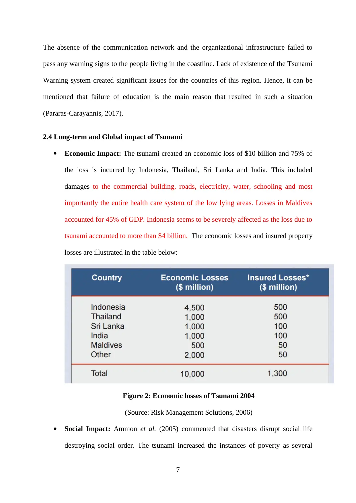
Economic Impact: The tsunami created an economic loss of $10 billion and 75% of
the loss is incurred by Indonesia, Thailand, Sri Lanka and India. This included
damages to the commercial building, roads, electricity, water, schooling and most
importantly the entire health care system of the low lying areas. Losses in Maldives
accounted for 45% of GDP. Indonesia seems to be severely affected as the loss due to
tsunami accounted to more than $4 billion. The economic losses and insured property
losses are illustrated in the table below:
Figure 2: Economic losses of Tsunami 2004
(Source: Risk Management Solutions, 2006)
Social Impact: Ammon et al. (2005) commented that disasters disrupt social life
destroying social order. The tsunami increased the instances of poverty as several
7
pass any warning signs to the people living in the coastline. Lack of existence of the Tsunami
Warning system created significant issues for the countries of this region. Hence, it can be
mentioned that failure of education is the main reason that resulted in such a situation
(Pararas-Carayannis, 2017).
2.4 Long-term and Global impact of Tsunami
Economic Impact: The tsunami created an economic loss of $10 billion and 75% of
the loss is incurred by Indonesia, Thailand, Sri Lanka and India. This included
damages to the commercial building, roads, electricity, water, schooling and most
importantly the entire health care system of the low lying areas. Losses in Maldives
accounted for 45% of GDP. Indonesia seems to be severely affected as the loss due to
tsunami accounted to more than $4 billion. The economic losses and insured property
losses are illustrated in the table below:
Figure 2: Economic losses of Tsunami 2004
(Source: Risk Management Solutions, 2006)
Social Impact: Ammon et al. (2005) commented that disasters disrupt social life
destroying social order. The tsunami increased the instances of poverty as several
7
Paraphrase This Document
Need a fresh take? Get an instant paraphrase of this document with our AI Paraphraser

people lost their houses and families. Furthermore, several individuals encountered
psychological trauma as several people became homeless, jobless and some were
unable to find the bodies of the closed ones. Child abuse became impertinent as
several children became orphans.
Environmental impact: The tsunami also created severe damages to the ecosystem
like coastal wetlands, mangroves, sand dunes and different varieties of flora and fauna
and most importantly coral reefs. The spread of solid waste and industrial chemicals
created water pollution. The freshwater supplies were contaminated with saltwater.
Further, due to the sea water coming to rivers and ponds and over the land, salt layer
was seen deposited, especially the one over the Arable land. The coral reed atolls that
were submerged by the seawater are without fresh water and would remain
inhabitable for decades (Pararas-Carayannis, 2017).
2.5 Likeliness of Tsunami and earthquake recurrence
Asia is a huge continent due to which more than one tectonic plate and sub tectonic plate is
present here. However, it is to be noted the geographical situation of Indonesia which is one
hand surrounded by the Pacific plate and from others Australian and Eurasian. Further, the
Phillipines plate is also there. Nonetheless, the plates are active which increases the risk of
underwater earthquakes and subsequently Tsunami (Pararas-Carayannis, 2017).
As the Burma tectonic plate went over the Indian plate, the subduction situation has released
huge energy and created rapture and thus slipped along the Andaman and Nicobar Island and
hence there lies little probability of a major earthquake in Northern Sumatra in near future.
However, stress would start building up. The region has encountered several aftershocks after
the earthquake and tsunami of 2004.
8

2.6 Contribution to science
The massive earthquake and the tsunami in 2004 have helped to learn the importance of
studying the seismic waves in the Indian and the Atlantic Ocean. The absence of effective
Tsunami Warning System created widespread damages to the life and property. For
preventing such havoc, in future three goals are set:
Active programmes from the school level to the national level for natural disaster
management
Creating Indian Ocean early warning system
Research programmes from the high school regarding earthquake
The Tsunami of 2004 has contributed to science by the development of a number of warning
systems among which Madagascar Plan Early Warning and Response System is best
developed in Mauritius. Government of countries in and around the Indian Ocean has
understood the importance of disaster and risk management programmes. The risk and
natural disaster management programme at Seychelles is one of them. The implementation of
the Indian Ocean Tsunami Warning and Mitigation System (IOTWMS) would help to
manage such disaster in future. Integrated Regional Information Network (IRIN) would help
in arranging vital tools for managing such disasters in the Indian Ocean. This incident has
made the countries more aware of the tsunami and earthquake (Ramalanjaona, 2011).
3.0 Conclusion
The earthquake resulted in faulting and slips that created huge tsunami waves. This caused
widespread damage in different counters on the Indian Ocean. Lack of awareness and
absence of proper warning system created such havoc. However, this disaster created
awareness and led to the development earthquake and tsunami warning system in the Indian
Ocean
9
⊘ This is a preview!⊘
Do you want full access?
Subscribe today to unlock all pages.
Trusted by 1+ million students worldwide

References
Ammon, C.J., Ji, C., Thio, H.K., Robinson, D., Ni, S., Hjorleifsdottir, V., Kanamori, H., Lay,
T., Das, S., Helmberger, D. and Ichinose, G., (2005). Rupture process of the 2004 Sumatra-
Andaman earthquake. Science, 308(5725), pp.1133-1139.
Cluff, L. S. (2007). Effects of the 2004 Sumatra-Andaman earthquake and Indian Ocean
tsunami in Aceh province. Bridge-Washington-National Academy Of Engineering-, 37(1), 12.
Dosomething.org. (2017). 11 Facts About the 2004 Indian Ocean Tsunami |
DoSomething.org | Volunteer for Social Change. Retrieved 20 November 2017, from
https://www.dosomething.org/facts/11-facts-about-2004-indian-ocean-tsunami
Ghobarah, A., Saatcioglu, M. and Nistor, I., (2006). The impact of the 26 December 2004
earthquake and tsunami on structures and infrastructure. Engineering Structures, 28(2),
pp.312-326.
Pararas-Carayannis, G. (2017). INDIAN OCEAN TSUNAMI - Great Earthquake and Tsunami
of 26 December 2004 in Southeast Asia and the Indian Ocean. Drgeorgepc.com. Retrieved
20 November 2017, from http://www.drgeorgepc.com/Tsunami2004Indonesia.html
Ramalanjaona, G., (2011). Impact of 2004 tsunami in the islands of Indian Ocean: lessons
learned. Emergency medicine international, 2011.
Rastogi, B.K., (2005). Why did the 28 March 2005 Sumatra earthquake of M w 8.7 generate
only a minor tsunami?. Current Science, 89(5), 731-732.
Risk Management Solutions. (2006). Managing Tsunami Risk in the Aftermath of the 2004
Indian Ocean Earthquake & Tsunami (pp. 1-24).
10
Paraphrase This Document
Need a fresh take? Get an instant paraphrase of this document with our AI Paraphraser

Telegraph.co.uk. (2017). 2004-Boxing-Day-tsunami-facts.html. Retrieved 20 November
2017, from http://www.telegraph.co.uk/news/worldnews/asia/11303114/2004-Boxing-Day-
tsunami-facts.html
Walrus.wr.usgs.gov (2017).Tsunamis and Earthquakes: Tsunami Generation from the 2004
Sumatra Earthquake - USGS PCMSC. Retrieved 20 November 2017, from
https://walrus.wr.usgs.gov/tsunami/sumatraEQ/tectonics.html
11
1 out of 11


Your All-in-One AI-Powered Toolkit for Academic Success.
+13062052269
info@desklib.com
Available 24*7 on WhatsApp / Email
![[object Object]](/_next/static/media/star-bottom.7253800d.svg)
Unlock your academic potential
Copyright © 2020–2026 A2Z Services. All Rights Reserved. Developed and managed by ZUCOL.