Global Positioning System (GPS) in Aircraft: An Engineering Report
VerifiedAdded on 2022/09/11
|10
|2178
|25
Report
AI Summary
This report provides a comprehensive overview of the Global Positioning System (GPS) in aeronautical engineering, emphasizing its critical role in enhancing aircraft safety and efficiency. It details the GPS system's features, including its network of satellites and ground stations, and its function in tracking and monitoring aircraft locations. The report examines the potential consequences of GPS failure, highlighting the importance of system redundancy and proper maintenance. It also explains how pilots interface with the GPS system, integrating it with flight management systems for navigation and performance monitoring. Furthermore, the report discusses how GPS data is presented to pilots and its integration with other aircraft systems, such as electronic flight instrument systems. The conclusion reinforces the significance of GPS in the aviation sector and its contribution to improved safety and navigation services. Desklib offers a range of resources, including past papers and solved assignments, to further support students' understanding of this topic.
GPS 0
The Global positioning system
(GPS) in the aeronautical
Engineering
The Global positioning system
(GPS) in the aeronautical
Engineering
Paraphrase This Document
Need a fresh take? Get an instant paraphrase of this document with our AI Paraphraser
GPS 1
Table of Contents
Introduction.................................................................................................................................................2
GPS System..................................................................................................................................................2
Features of the GPS system.........................................................................................................................2
Role of GPS in aircraft..................................................................................................................................3
What happens if GPS goes wrong?..............................................................................................................4
How the pilots interface GPS system...........................................................................................................4
How GPS present information.....................................................................................................................5
GPS interfaces with other aircraft systems..................................................................................................6
Conclusion...................................................................................................................................................6
References...................................................................................................................................................8
GPS 2
Introduction
The term GPS refers to the global positioning system which is a kind of navigation system
including a constellation of satellites and a network of ground stations for monitoring
locations. It is a satellite-based system developed by the United States government and
operated by the US air force (Dornan, et al., 2018). The major point of GPS is that it does not
require the consumers to transfer any signal and it operates independently of any internet
reception using communication protocols. The significance of this research is to determine
the importance of the GPS system in the aeronautical engineering and aviation sectors. It is
argued that GPS plays a major role in the aviation sector as it helps to monitor the locations
of aircraft and reduce barriers. This report will cover numerous aspects such as the
working of GPS, features of GPS, the role of GPS in aircraft and many more.
GPS System
It is defined as a space-based radio system which is mainly used for navigation purpose
that means users can track and monitor the location of another device. From the recent
study, it is examined that the GPS system delivers reliable location and time information in
all situations and helps consumers to control and monitor the navigation of others. It is
argued that the GPS system plays a crucial character in aircraft as it is capable to track the
location of aircraft in an effective manner (Haass, Craiger, and Kessler, 2018). It is mainly
used in the aviation sectors for monitoring the current location of aircraft which helps in
the reduction of aircraft crash and other accidents. It has the potential to enhance the
safety and effectiveness of flight due to which it is used in the aircraft systems. Therefore,
using GPS systems management can take departure, arrival and en-route information of
aircraft in an appropriate manner.
Features of the GPS system
A GPS is a network of satellites which is used to find the location of something on earth. It is
found that the GPS system contains 24 satellites that circle the earth in precise orbits. In
which every satellite makes a full orbit of the earth every 12 hours. Such kinds of satellites
⊘ This is a preview!⊘
Do you want full access?
Subscribe today to unlock all pages.
Trusted by 1+ million students worldwide
GPS 3
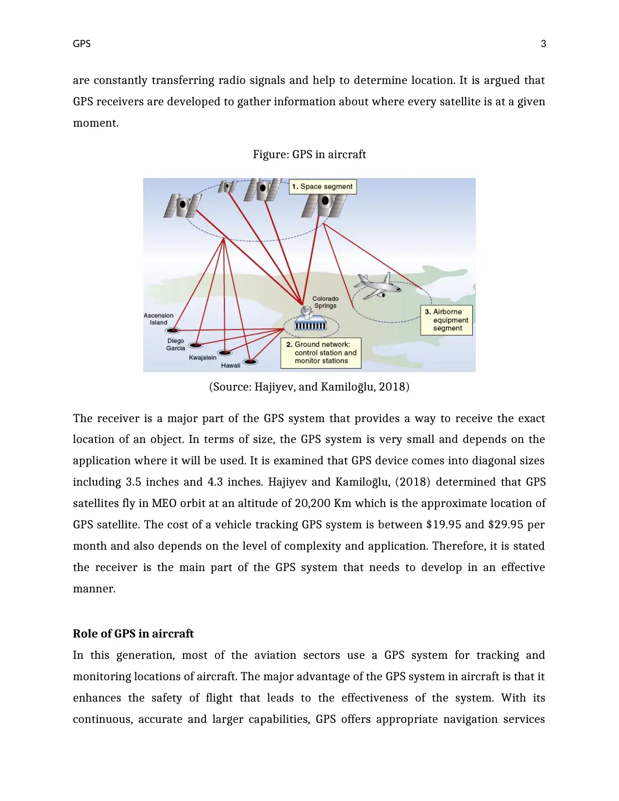
are constantly transferring radio signals and help to determine location. It is argued that
GPS receivers are developed to gather information about where every satellite is at a given
moment.
Figure: GPS in aircraft
(Source: Hajiyev, and Kamiloğlu, 2018)
The receiver is a major part of the GPS system that provides a way to receive the exact
location of an object. In terms of size, the GPS system is very small and depends on the
application where it will be used. It is examined that GPS device comes into diagonal sizes
including 3.5 inches and 4.3 inches. Hajiyev and Kamiloğlu, (2018) determined that GPS
satellites fly in MEO orbit at an altitude of 20,200 Km which is the approximate location of
GPS satellite. The cost of a vehicle tracking GPS system is between $19.95 and $29.95 per
month and also depends on the level of complexity and application. Therefore, it is stated
the receiver is the main part of the GPS system that needs to develop in an effective
manner.
Role of GPS in aircraft
In this generation, most of the aviation sectors use a GPS system for tracking and
monitoring locations of aircraft. The major advantage of the GPS system in aircraft is that it
enhances the safety of flight that leads to the effectiveness of the system. With its
continuous, accurate and larger capabilities, GPS offers appropriate navigation services
Paraphrase This Document
Need a fresh take? Get an instant paraphrase of this document with our AI Paraphraser
GPS 4
that satisfy numerous requirements for aviation consumers. Hamshaw, et al., (2017)
argued that spaced based position and navigation allow a 3-dimensional location for all
phases of aircraft including departure, arrival, and others. It is observed that area
navigation enables aircraft to fly user-preferred routes from waypoint to waypoint.
Advanced air routes made possible using GPS systems and reduced the issues associated
with navigation. It is true that the utilization of GPS systems enhanced approaches to
airports, which effectively enhance operational advantages and security of devices. The
good point for the aviation sector is that GPS systems constantly enhanced and modernized
aircraft. Therefore, it is stated the GPS systems enhance the safety and effectiveness of
aircraft due to which aviation sector uses GPS devices.
What happens if GPS goes wrong?
It is argued that GPS systems manage the safety and efficiency of aircraft in a reliable
manner. If the GPS system goes wrong the aviation sectors may face safety and serious
injuries problems which may affect the performance of the systems. Krasuski and Ćwiklak,
(2017) observed that the GPS system uses internet connection and lack of proper
communication can lead to data breach issues in the networks. So, if the GPS goes wrong,
the ramification would not be a limitation in the aircraft and lead to serious issues in
aviation sectors. It is important for the management to check and monitor developed GPS
system and if duplicate networks and signals occur in the system team should address
immediately. Therefore, it is stated the occurrence of duplicate networks in GPS systems
can lead to serious issues and produce problems in the departure and arrival time of
airplanes.
How the pilots interface GPS system
GPS system is used in the aircraft for managing the safety and effectiveness of the
networks. In which the pilot uses a GPS system for finding the exact location and managing
arrival time on a regular basis. Most of the pilots take proper training for operating and
interfacing GPS systems in the aircraft. It is found that the pilot interfaces GPS system with
the flight management system and monitors the overall performance and location of
GPS 5
aircraft. Pilot utilizes the GPS system as an aid to visual flight rules navigation (Lee, et al.,
2016). Using such a process pilot is capable to check errors and manage performance in a
reliable manner.
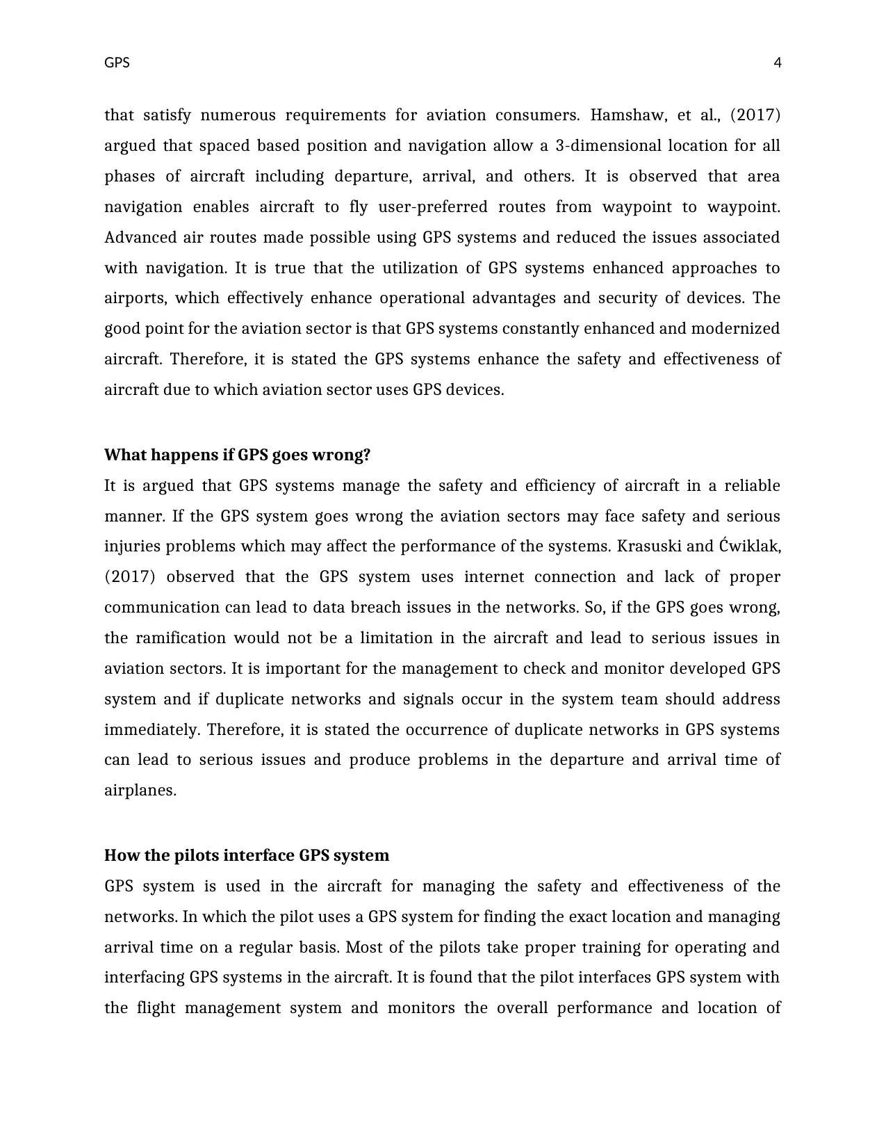
Figure: GPS system
(Source: Lee, et al., 2016)
GPS reliability has led the pilot to depart VFR on days when the visibility is low for
navigation. When the weather is marginal, the pilot should assume GPS is not available the
decision whether to depart. It is important to take proper training for handling the working
of the GPS system and reducing errors. Therefore, the pilot connects GPS systems with the
FMS system and performs navigation activities by which the performance of aircraft can be
managed effectively.
How GPS present information
The GPS concept is grounded on time and position of GPS satellite. It provides a way to
address errors and enhance the safety of aircraft effectively. Pilot use GPS system for
monitoring performance of aircraft in which they connect GPS with FSM system. The
aircraft. Pilot utilizes the GPS system as an aid to visual flight rules navigation (Lee, et al.,
2016). Using such a process pilot is capable to check errors and manage performance in a
reliable manner.
Figure: GPS system
(Source: Lee, et al., 2016)
GPS reliability has led the pilot to depart VFR on days when the visibility is low for
navigation. When the weather is marginal, the pilot should assume GPS is not available the
decision whether to depart. It is important to take proper training for handling the working
of the GPS system and reducing errors. Therefore, the pilot connects GPS systems with the
FMS system and performs navigation activities by which the performance of aircraft can be
managed effectively.
How GPS present information
The GPS concept is grounded on time and position of GPS satellite. It provides a way to
address errors and enhance the safety of aircraft effectively. Pilot use GPS system for
monitoring performance of aircraft in which they connect GPS with FSM system. The
⊘ This is a preview!⊘
Do you want full access?
Subscribe today to unlock all pages.
Trusted by 1+ million students worldwide
GPS 6
control segment of GPS includes 5 monitor stations, 3 grounded antennas and master
control for managing processes effectively (Logan, Glaab, and Craig, 2016). The pilot
segment contains antennas and receiver processes that deliver velocity, positioning and
precise time of aircraft to the pilot.
In the relation of the GPS system, the pilot transmits a signal to the FSM system which is
connected with the GPS device where the signal is performed as per the developed network
and reflect to the receiver antenna (Maguire, et al., 2017). It is observed that there are two
networks include in the aircraft for managing GPS systems such as readouts and controls.
The pilot receives output signal on the main screen and read collected data in a reliable
manner. It is found that the GPS system uses two forms of clock signals including coarse
code and restricted precise code. In which coarse code is used for the public and restricted
code is used for the aviation sector. Therefore, in aircraft precise code is used for
transferring information from the GPS systems to the pilot.
GPS interfaces with other aircraft systems
It is argued that GPS is the best system that has the potential to reduce errors and lead to
the efficiency of aircraft. From a recent study, it is described that the GPS system interface
with the flight management system and electronic flight instrument systems for handling
performance and safety issues. Moreover, the PFD and navigation display both are
connected with the GPS system in which the information displayed is examined by the
system interface where the display units are fitted. In the relation of aviation and
aeronautical engineering sector utilization of GPS systems is helpful due to their larger
reliability and effectiveness in the navigation. Pollack and Ranganathan, (2018) examined
that ASAS human machine is also interfaced with the GPS system for automatically
managing operations of aircraft and supporting delegation of departure responsibility.
Conclusion
From this investigation, it can be concluded that the GPS system plays a significant role in
the aviation sector as it is capable to enhance safety and efficiency level of aircraft. This
report reviewed the concept of the GPS system and identified key features of the GPS
Paraphrase This Document
Need a fresh take? Get an instant paraphrase of this document with our AI Paraphraser

GPS 7
system used in the aircraft. It is identified that the GPS system is helpful for aircraft and
aeronautical engineering sectors for managing safety issues and providing navigation-
related services. This proposed research provided depth examination related to the GPS
system by which readers can enhance their skills in the relation of the GPS system and the
aviation sector.
GPS 8
References
Dornan, W.A., Beckman, W., Gossett, S. and Craig, P.A., (2018) A FITS scenario-based
training program enhances GPS pilot proficiency in the general aviation pilot. The
Collegiate Aviation Review International, 25(1), pp. 12-18.
Haass, J.C., Craiger, J.P. and Kessler, G.C., (2018) A Framework for Aviation Cybersecurity.
In NAECON 2018-IEEE National Aerospace and Electronics Conference, 12(6), pp. 132-136.
Hajiyev, C. and Kamiloğlu, D.B., (2018) Design of loosely-coupled INS/GPS integration
system applied to the Boeing-747 aircraft model. International Journal of Sustainable
Aviation, 4(3-4), pp.163-177.
Hamshaw, S.D., Bryce, T., Rizzo, D.M., O'Neil‐Dunne, J., Frolik, J. and Dewoolkar, M.M.,
(2017) Quantifying streambank movement and topography using unmanned aircraft
system photogrammetry with comparison to terrestrial laser scanning. River research and
applications, 33(8), pp.1354-1367.
Krasuski, K. and Ćwiklak, J., (2017) Application of GPS sensor for recovery of the precise
position of aircraft in air transport. In Proceedings of 16th International Scientific
Conference Engineering for Rural Development, 16(5), pp. 222-229).
Lee, J., Pullen, S., Datta-Barua, S. and Lee, J., (2016) Real-time ionospheric threat adaptation
using a space weather prediction for GNSS-based aircraft landing systems. IEEE
Transactions on Intelligent Transportation Systems, 18(7), pp.1752-1761.
Logan, M.J., Glaab, L. and Craig, T., (2016) Use of a Small Unmanned Aircraft System for
autonomous fire spotting at the Great Dismal Swamp. In AIAA Infotech@ Aerospace, 12(6),
p. 1004).
Maguire, M.S., Woldt, W.E., Frew, E.E., Smith, J. and Elston, J., (2017) Thermal infrared and
multi-spectral dual-sensor integration for unmanned aircraft systems. In 2017 ASABE
Annual International Meeting, 12(7), pp. 10-15.
⊘ This is a preview!⊘
Do you want full access?
Subscribe today to unlock all pages.
Trusted by 1+ million students worldwide

GPS 9
Pollack, J. and Ranganathan, P., (2018) Aviation Navigation Systems Security: ADS-B, GPS,
IFF. In Proceedings of the International Conference on Security and Management (SAM),
12(7), pp. 129-135.
Pollack, J. and Ranganathan, P., (2018) Aviation Navigation Systems Security: ADS-B, GPS,
IFF. In Proceedings of the International Conference on Security and Management (SAM),
12(7), pp. 129-135.
1 out of 10
Related Documents


Your All-in-One AI-Powered Toolkit for Academic Success.
+13062052269
info@desklib.com
Available 24*7 on WhatsApp / Email
![[object Object]](/_next/static/media/star-bottom.7253800d.svg)
Unlock your academic potential
Copyright © 2020–2026 A2Z Services. All Rights Reserved. Developed and managed by ZUCOL.