Location Tracking Android App Development Project in Android Studio
VerifiedAdded on 2020/04/21
|15
|1506
|257
Project
AI Summary
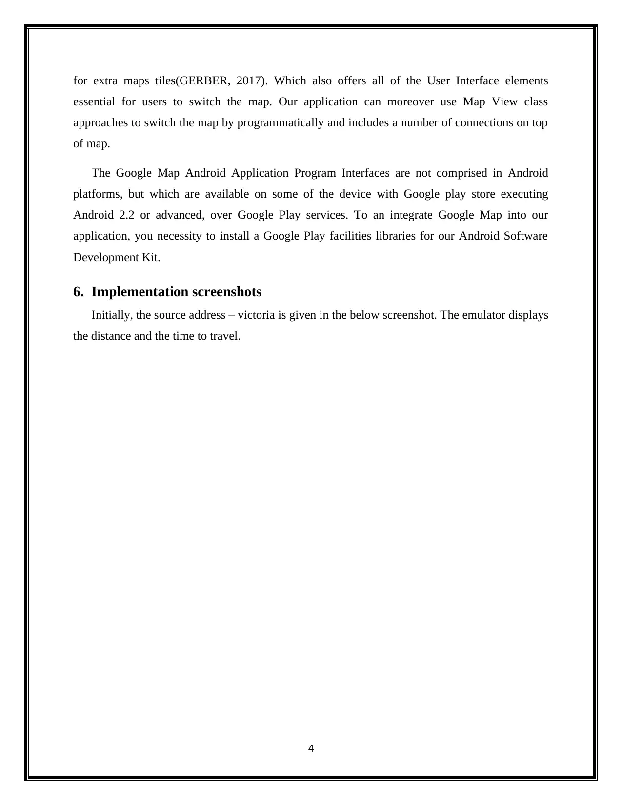
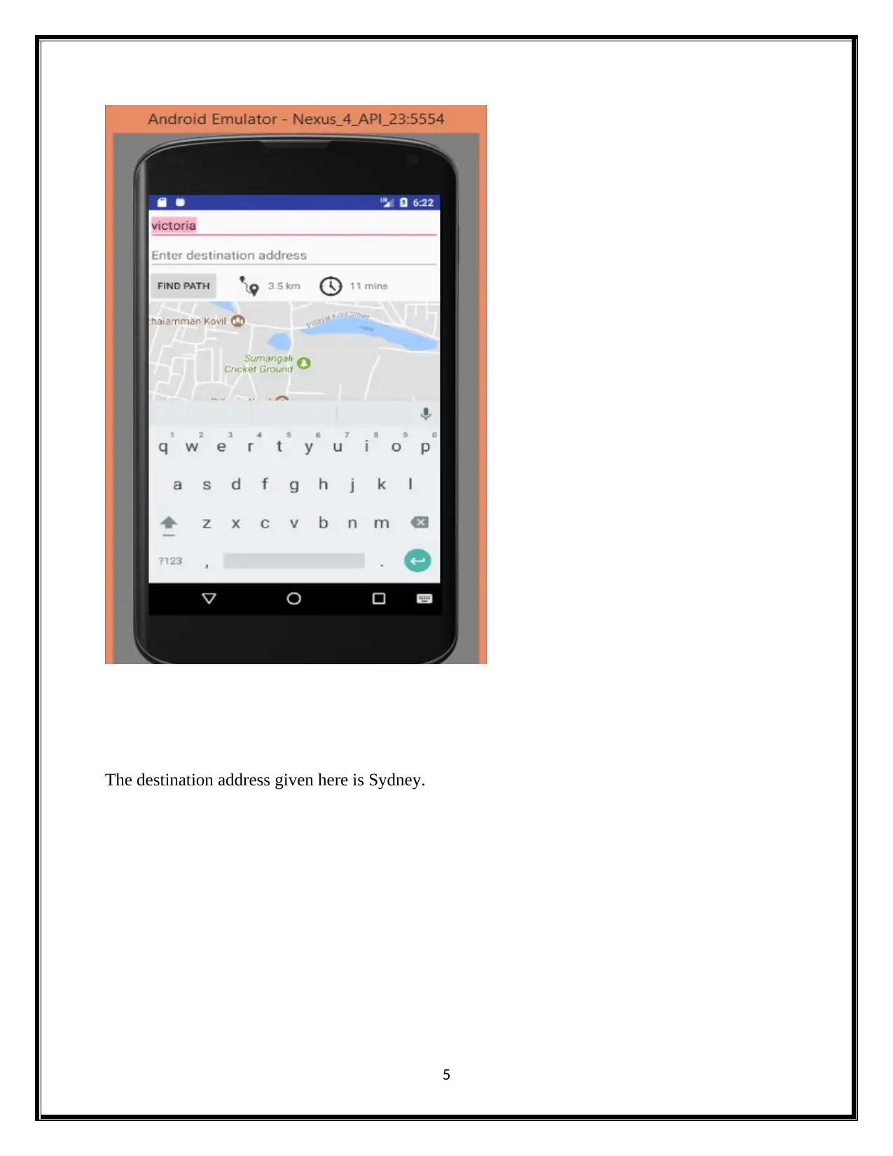
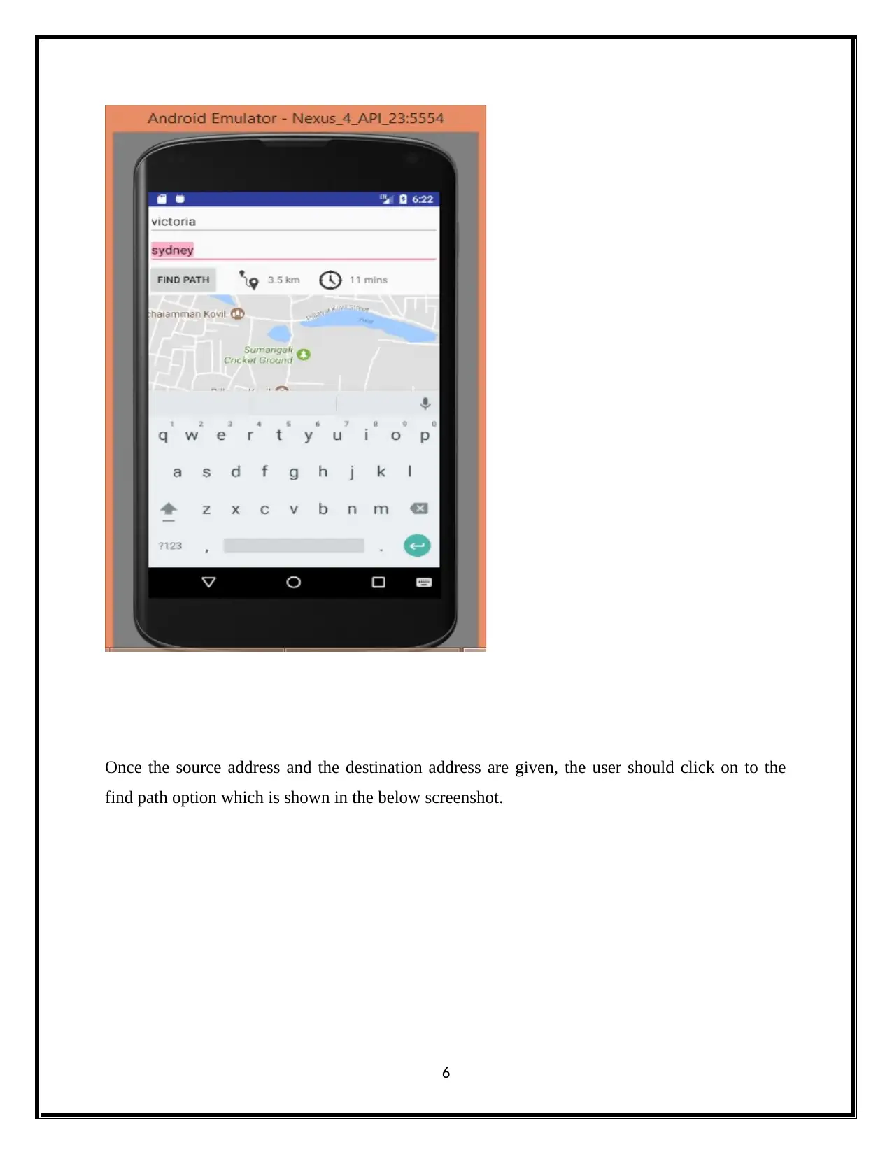
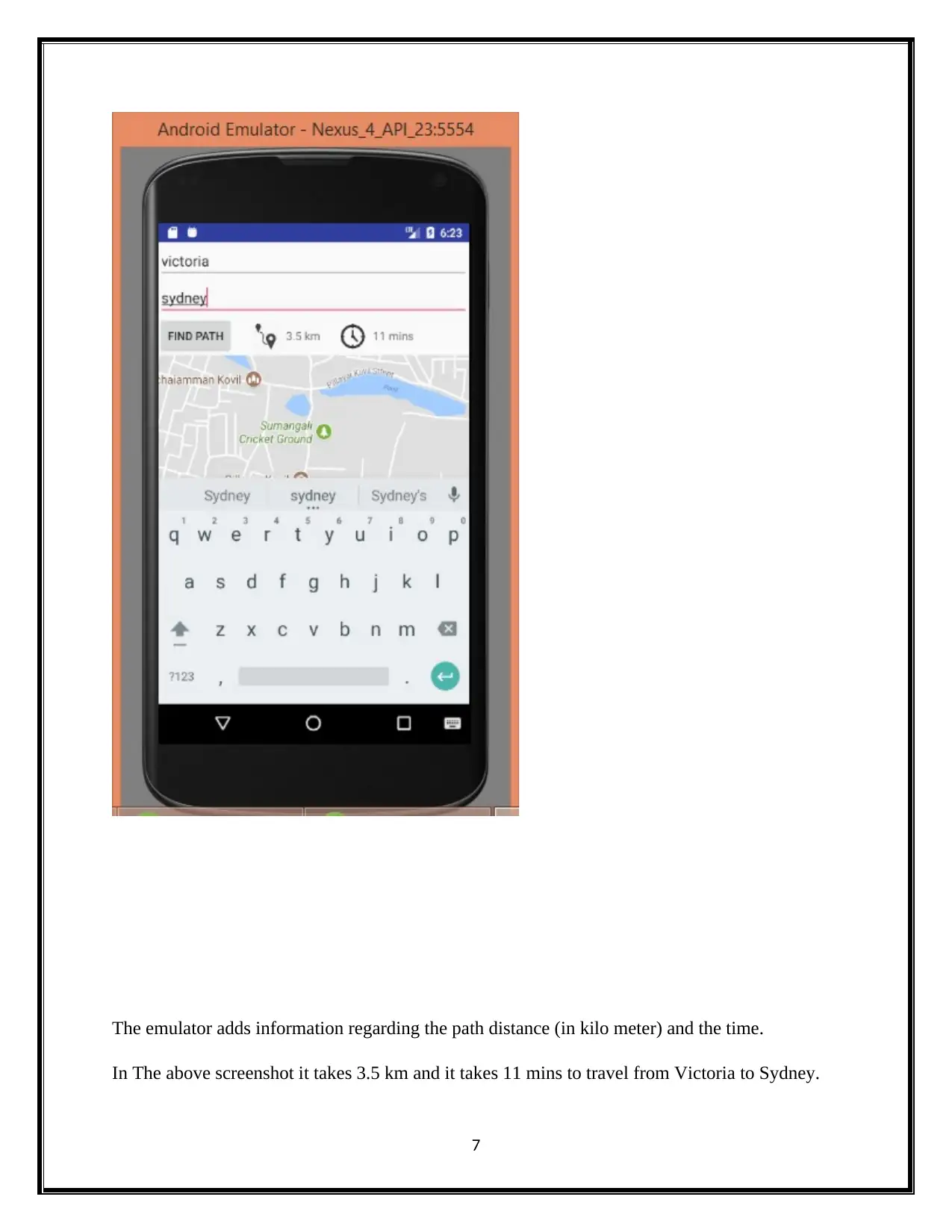
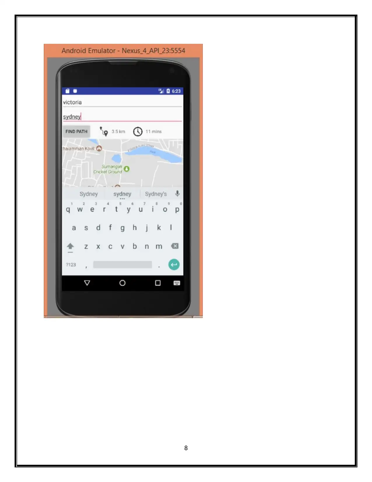
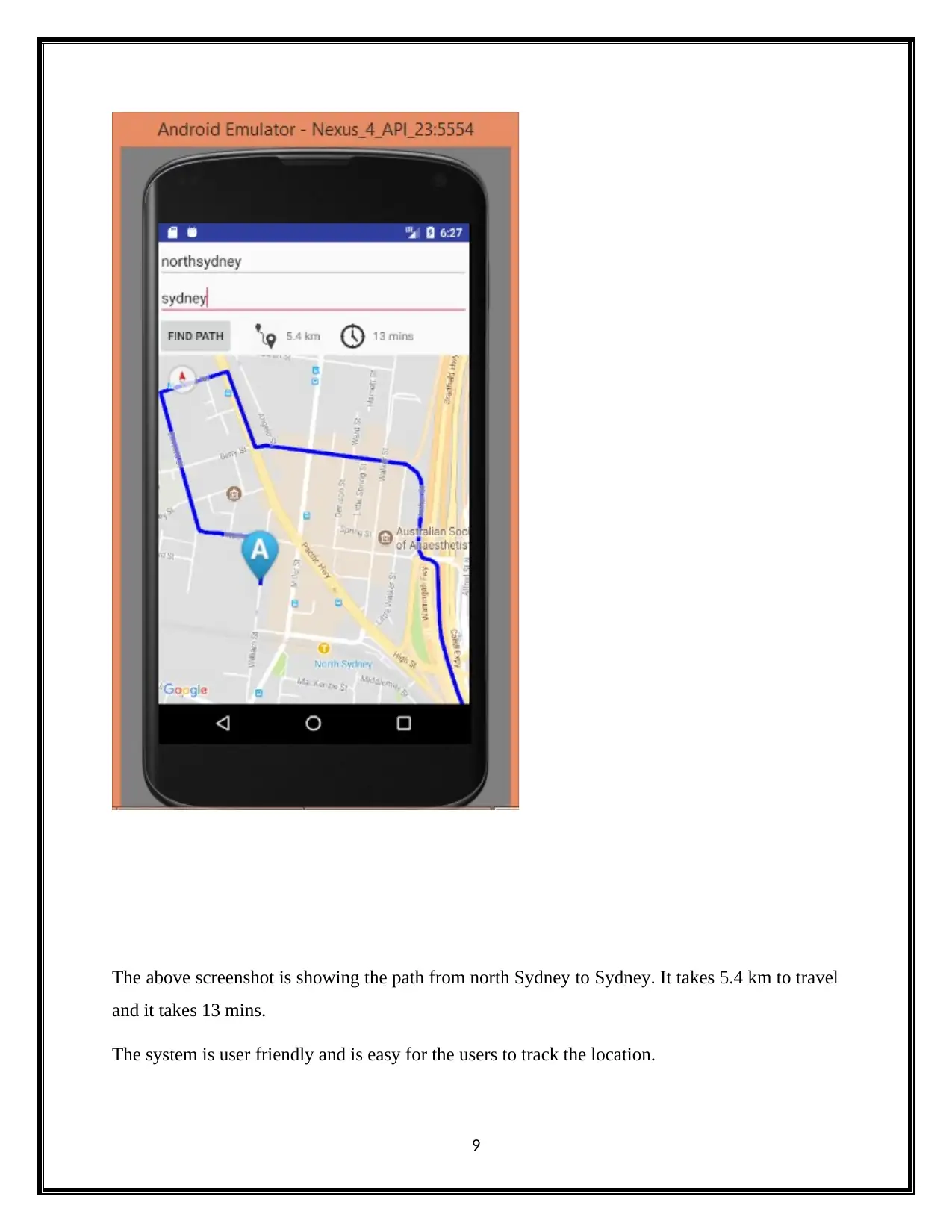
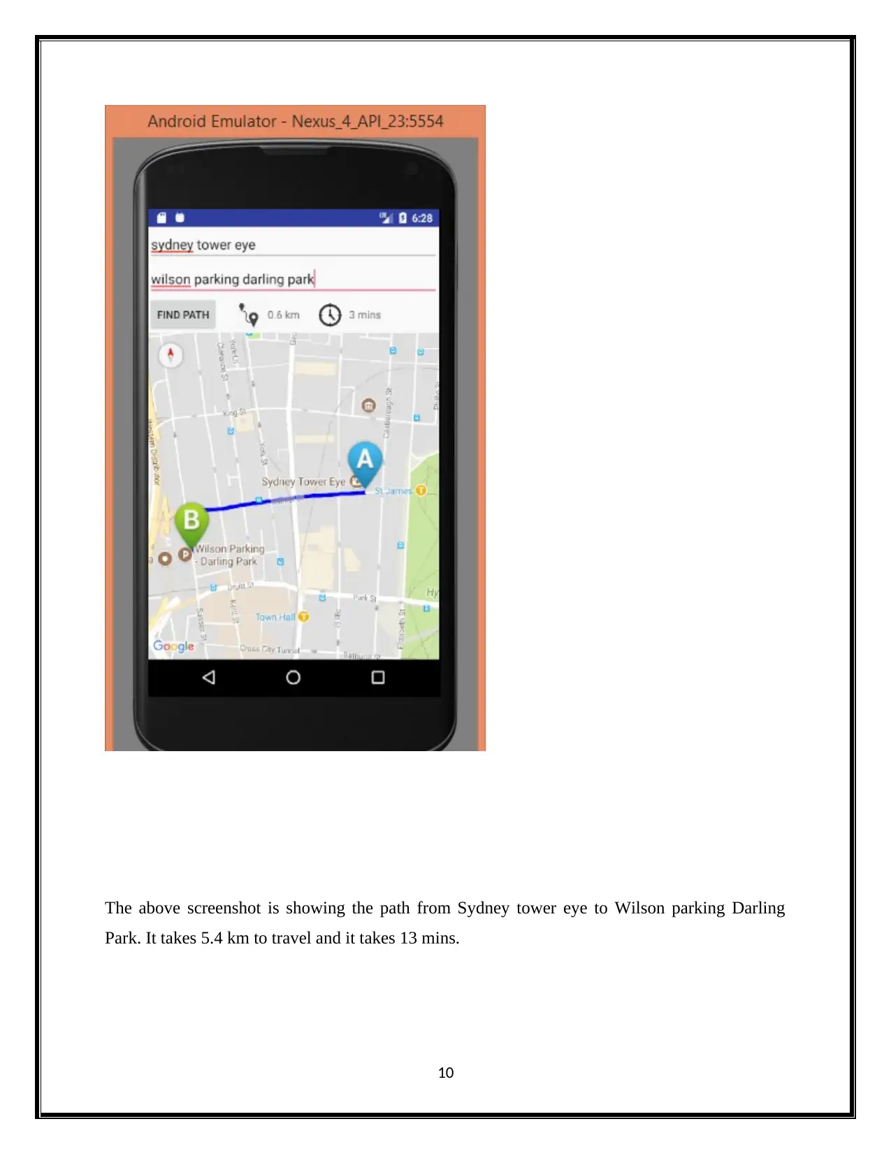
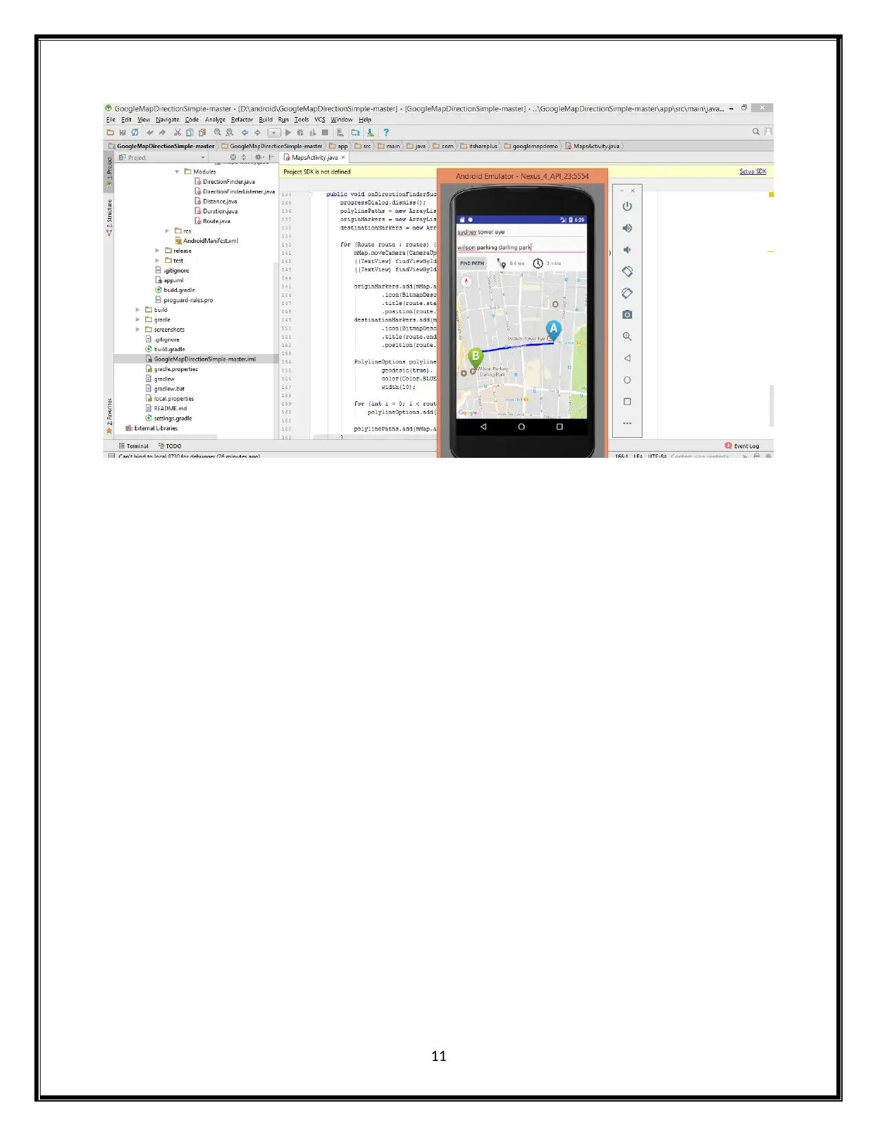
This project report details the development of an Android mobile application designed for location tracking, built using Android Studio. The application utilizes the Google Maps API to display user locations, track routes, and provide navigation functionalities. The project focuses on integrating location services, handling map displays, and responding to user gestures within the Android Studio environment. The application allows users to input source and destination addresses, displaying the path, distance, and estimated travel time. The report includes implementation screenshots, showcasing the user interface and functionality of the app, demonstrating features such as pathfinding from Victoria to Sydney and North Sydney to Sydney. The project underscores the application's user-friendly design and ease of use for location tracking purposes. The project also reviews the use of Android Studio's features and the integration of Google Maps services for navigation, providing a comprehensive overview of the development process. The conclusion highlights the successful implementation of the location tracking app, emphasizing its ability to display distances, travel times, and generate maps within the Android Studio environment.

WEB APP Software Work
Paraphrase This Document
Need a fresh take? Get an instant paraphrase of this document with our AI Paraphraser

1. Introduction
The aim of the proposed project is mainly to develop an application for the Android mobile
platform. The application will track the exact place for portable devices and purposes to
encourage the social integration and distribution of those routes within the community in
Android studio. The implementation will be done in android studio and the tracking location of
the source, destination will be shown accordingly. the map will be generated in android studoio.
this will maps the location to the users and handles the map display and it responses to the map
gestures. Additionaly it will display the distance and time of source and the destination given by
the user.
2. Android studio
a. Android studio is the IDE (Integrated Development Environment) for google android
OS.
b. It is a Gradle build support and android specific refactoring and fast links.
c. Android studio contains the lint tool to catch presentation performance, usability and
version type compatibility.
d. AVD (Android Virtual Device) or emulator to debug and run the applications in
android studio.
Android studio supports the number of languages. It is an easy to use and free
development environments. Android Studio offers the fastest and wildest tools for constructing
applications on each and every kind of Android device. The process for creating new application
in android studio is given below:
1. Click file menu then choose the new project
2. Type the application name and click the next button.
3. Select the phone and tablet option and click the next button. Then, new application is created
in android studio (Smyth, n.d.).
1

3. Map services for navigation
Usage of android studio map services for navigation
The mobile application called Google map navigation which is developed by Google. It is
developed for iOS operating systems and android. It was integrated into mobile app called
Google map. The mobile application utilize internet connection to global positioning system
navigation system. Turn-by-turn voice directed instruction is provided by Google maps (Zapata,
2016). It gives the instruction to arrive destination. It needs internet connection. It usually uses
global positioning system satellite connection. It is to determine the location. If the user enter the
destination in Google map mobile application, it plots a path to the destination from source
address. The mobile application shows progress of users along with issues and route instructions
for every turn (Baloni, 2016).
Guide to add a map to the android application
To build the application with android API Google map, android studio is suggested.
1) Downloading android studio
To install and download the android studio, guides should be followed.
2) Installation of SDK Google play service
Adding Google play services to the android studio is the second step.
3) Creating Google map
For creating new application project
For creating new application project which includes map task, the following steps should follow.
1. Begin android studio
2. Creating new project
3. Entering application name, location, etc. and click to the next.
4. For the application, choose form factor. Or just choose phone & tablet and click to next.
5. In the activity add to mobile dialog, choose goggle map activity and click to next.
6. Entering name of the activity, title and layout name as prompted. And click to finish.
2
⊘ This is a preview!⊘
Do you want full access?
Subscribe today to unlock all pages.

Trusted by 1+ million students worldwide

4. Data flow and Location services
The Google Map provides an awareness in location through the Android application. This
illustrates the location of the user by using the Service API that is available in the google
location services. The details of the location is been abstracted from the location providers. The
location providers are of three types. They are
Network provider-Combination of cellular data and WiFi
Passive Providers- This is an optional that is provided by the other application or services.
GPS Providers-This gives the most accurate location which is a combination of aGPS and
GPS.
For the dataflow in the Google Maps a pipeline is been represented. It consist of a set of
operation so that a source of input data can be read (DiMarzio, n.d.). With the help of the Google
maps the event can also be viewed on the map. For the location tracking in the Google maps the
departure and the arrival location can be drag and dropped. A most complete and authoritative
data is been used for the location tracking this is done with the map partner called base map
partner program. The base map partner program contains all the details related to the geography
and the maps. A vector data is been added to the Google's base map for updating the locations
information.
5. Google Maps with Android Application Program Interface
The Google Maps with Android Application Program Interface, we can enhance maps to
our application. The application is based on the Google Maps statistics. The Application
Program Interface automatically switch to access the Google Map servers, map show
information, downloading, and touch gesticulations on the maps. We can also utilize the
Application Program Interface calls to enhance markers, overlays and polygons, and to
transforms the user's vision of a specific map area (Developer.android.com, 2017).
The important discussion in the Google Maps Android studio Application Program
Interface is Map View. A Map View shows the map with information found from the Google
Maps facility. When a Map View have focus, then it will imprisonment touch gestures and key
presses to pan and increase view point of the maps automatically, with handling system requests
3
Paraphrase This Document
Need a fresh take? Get an instant paraphrase of this document with our AI Paraphraser

for extra maps tiles(GERBER, 2017). Which also offers all of the User Interface elements
essential for users to switch the map. Our application can moreover use Map View class
approaches to switch the map by programmatically and includes a number of connections on top
of map.
The Google Map Android Application Program Interfaces are not comprised in Android
platforms, but which are available on some of the device with Google play store executing
Android 2.2 or advanced, over Google Play services. To an integrate Google Map into our
application, you necessity to install a Google Play facilities libraries for our Android Software
Development Kit.
6. Implementation screenshots
Initially, the source address – victoria is given in the below screenshot. The emulator displays
the distance and the time to travel.
4

The destination address given here is Sydney.
5
5
⊘ This is a preview!⊘
Do you want full access?
Subscribe today to unlock all pages.

Trusted by 1+ million students worldwide

Once the source address and the destination address are given, the user should click on to the
find path option which is shown in the below screenshot.
6
find path option which is shown in the below screenshot.
6
Paraphrase This Document
Need a fresh take? Get an instant paraphrase of this document with our AI Paraphraser

The emulator adds information regarding the path distance (in kilo meter) and the time.
In The above screenshot it takes 3.5 km and it takes 11 mins to travel from Victoria to Sydney.
7
In The above screenshot it takes 3.5 km and it takes 11 mins to travel from Victoria to Sydney.
7

8
⊘ This is a preview!⊘
Do you want full access?
Subscribe today to unlock all pages.

Trusted by 1+ million students worldwide

The above screenshot is showing the path from north Sydney to Sydney. It takes 5.4 km to travel
and it takes 13 mins.
The system is user friendly and is easy for the users to track the location.
9
and it takes 13 mins.
The system is user friendly and is easy for the users to track the location.
9
Paraphrase This Document
Need a fresh take? Get an instant paraphrase of this document with our AI Paraphraser

The above screenshot is showing the path from Sydney tower eye to Wilson parking Darling
Park. It takes 5.4 km to travel and it takes 13 mins.
10
Park. It takes 5.4 km to travel and it takes 13 mins.
10

11
⊘ This is a preview!⊘
Do you want full access?
Subscribe today to unlock all pages.

Trusted by 1+ million students worldwide
1 out of 15
Related Documents

Your All-in-One AI-Powered Toolkit for Academic Success.
+13062052269
info@desklib.com
Available 24*7 on WhatsApp / Email
Unlock your academic potential
Copyright © 2020–2025 A2Z Services. All Rights Reserved. Developed and managed by ZUCOL.