Assessment Report: NSW Building in Bushfire Prone Areas Analysis
VerifiedAdded on 2023/06/03
|22
|4238
|233
Report
AI Summary
This report provides an assessment of building in bushfire-prone areas in New South Wales (NSW), focusing on planning legislation, proposed developments, and compliance with relevant regulations. The assessment covers site description, aerial views, and the importance of planning in mitigating fire risks, including fuel load assessment and material selection. It highlights the role of the Environmental Protection Authority (EPA) and State Environmental Planning Policies (SEPPs) in land use planning and development control. The report details asset protection zones (APZs), building materials standards (AS 3959-2009), and landscaping considerations for bushfire management. Plant selection and pool design are also addressed in the context of minimizing fire risks. The document emphasizes adherence to construction standards, radiant heat accommodation, and the overall stability of structures in bushfire-prone environments. Desklib provides a platform for students to access this and other solved assignments.
NEW SOUTH WALES Building in Bushfire Prone Areas 1
Assessment Report on:
NEW SOUTH WALES Building in Bushfire Prone Areas
By Student’s Name
Code + Course Name
Professor’s Name
University Name
City, State
Date
Assessment Report on:
NEW SOUTH WALES Building in Bushfire Prone Areas
By Student’s Name
Code + Course Name
Professor’s Name
University Name
City, State
Date
Paraphrase This Document
Need a fresh take? Get an instant paraphrase of this document with our AI Paraphraser
NEW SOUTH WALES Building in Bushfire Prone Areas 2
Table of Contents
1. Introduction.........................................................................................................................................3
2. Site.......................................................................................................................................................4
2.1. Site Description and Area of Study..............................................................................................4
2.2 Aerial View Photos.......................................................................................................................5
3. Planning Legislation.............................................................................................................................5
4. Proposed Development.....................................................................................................................10
4.1 SEPP Requirements of the Site..................................................................................................10
4.2 Building Materials......................................................................................................................10
4.3 Landscaping...............................................................................................................................10
4.3.1 Plant Selection...................................................................................................................11
4.3.2 Pool....................................................................................................................................12
5.0 Conclusion.....................................................................................................................................18
6.0 References.....................................................................................................................................21
7.0 Appendix........................................................................................................................................25
NEW SOUTH WALES Building in Bushfire Prone Areas 3
1. Introduction
A bushfire prone are is an environment accessed and investigations done on the probability of
fire outbreak by a state. The considerations of determining a bushfire prone area vary in
different states. Each state has set rules and regulations regarding the construction of houses in
such areas. These regulations are made to ensure in the case of fire outbreak, the structures do
not get burnt up or the intensity of heat to have a negative impact to the structure. Building in
these areas calls for special design foe structures that may bring up additional costs to the normal
construction cost. Bush fire areas are not only located in bush areas but also in other localities
such as city residential areas whereby there is a possibility of fire outbreak (Holland et al. 2013
p.41).
Building in an inclined bushfire region presents some of the new design outline, specifications,
and considerations as well as the construction parameters which one cannot overlook. These
extra necessities add additional expenses to another home, so it is critical to take note of that
there is typically more than one choice accessible to constructors and manufacturers to meet the
prerequisites of the building controls and benchmarks. Similarly, working in bushfire inclined
territories does not imply that conventional building materials, for example, timber window and
door jambs are disallowed. Despite what might be expected, timber windows as well as
entryways that have been bushfire tried to meet the brilliant warmth and fire introduction
necessities of the Australian Standard AS 1530 are appropriate for use in bushfire inclined zones
(Niven and Bardsley 2013 p.193).
⊘ This is a preview!⊘
Do you want full access?
Subscribe today to unlock all pages.
Trusted by 1+ million students worldwide
NEW SOUTH WALES Building in Bushfire Prone Areas 4
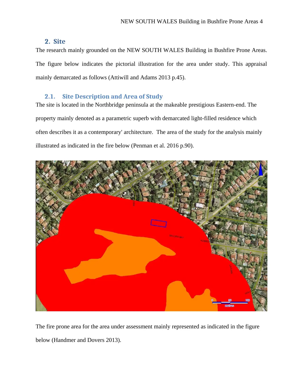
2. Site
The research mainly grounded on the NEW SOUTH WALES Building in Bushfire Prone Areas.
The figure below indicates the pictorial illustration for the area under study. This appraisal
mainly demarcated as follows (Attiwill and Adams 2013 p.45).
2.1. Site Description and Area of Study
The site is located in the Northbridge peninsula at the makeable prestigious Eastern-end. The
property mainly denoted as a parametric superb with demarcated light-filled residence which
often describes it as a contemporary' architecture. The area of the study for the analysis mainly
illustrated as indicated in the fire below (Penman et al. 2016 p.90).
The fire prone area for the area under assessment mainly represented as indicated in the figure
below (Handmer and Dovers 2013).
Paraphrase This Document
Need a fresh take? Get an instant paraphrase of this document with our AI Paraphraser
NEW SOUTH WALES Building in Bushfire Prone Areas 5
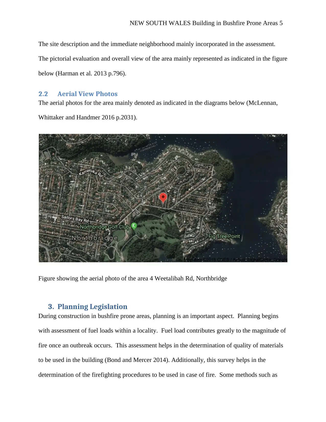
The site description and the immediate neighborhood mainly incorporated in the assessment.
The pictorial evaluation and overall view of the area mainly represented as indicated in the figure
below (Harman et al. 2013 p.796).
2.2 Aerial View Photos
The aerial photos for the area mainly denoted as indicated in the diagrams below (McLennan,
Whittaker and Handmer 2016 p.2031).
Figure showing the aerial photo of the area 4 Weetalibah Rd, Northbridge
3. Planning Legislation
During construction in bushfire prone areas, planning is an important aspect. Planning begins
with assessment of fuel loads within a locality. Fuel load contributes greatly to the magnitude of
fire once an outbreak occurs. This assessment helps in the determination of quality of materials
to be used in the building (Bond and Mercer 2014). Additionally, this survey helps in the
determination of the firefighting procedures to be used in case of fire. Some methods such as
NEW SOUTH WALES Building in Bushfire Prone Areas 6
water may be inappropriate in putting down fire in a high rate fuel manifested are. This survey
therefor helps in the appropriate choice of options.
The normal building materials such as timber are not avoided in the construction in bushfire
prone areas. Only the given quality of timber is used that can withstand high temperatures and
its quality is not affected by heat and meets the radiant heat standards. This is ensured by
following the construction regulations set to enhance adherence of quality. The structures follow
a regulation that caters for the provision of adherence in case of fire outbreak. This is focused on
the structure on how it should contain the extreme temperatures and be able to remain stable
even after fire attack. All the regulations should be put in place to ensure that the structure does
not collapse. Additionally, there is a regulation regarding the accommodation of radiant heat
from a bushfire to the structure (Mannakkara and Wilkinson 2014). This regulation ensures that
all the materials used I the construction are strong enough to withstand the high intensity heat
radiation from a nearing bushfire. Moreover, the regulations are also focused on the potential
probability of ignition of the structure in the case of extreme fire attack. The construction
standards are based on the predetermined severity of fire by the state. The intensity can be low,
moderate, high or extremely high depending on the locale of the site. These considerations
enhance better prediction on the quality of materials to be used for construction in each area. A
higher standard of construction materials can be used to prevent damage in case of a bushfire.
For example, the gauge designed to be used in the construction of moderate risk fire exposure
building can be used for the low risk fire exposure building so as to reduce the doubt of damage
in case of fire (Moritz et al. 2014 p.58).
EPA (ENVIRONMENTAL PROTECTION AUTHORITY) NSW
⊘ This is a preview!⊘
Do you want full access?
Subscribe today to unlock all pages.
Trusted by 1+ million students worldwide
NEW SOUTH WALES Building in Bushfire Prone Areas 7
According to Blanchi et al. ( 2014), “Environmental circumstances surrounding bushfire
fatalities in Australia 1901–2011,” Both the EA policy as well as the overall acts helps in
governing the application and the utilization of land use planning in the New South Wales
region. This provision helps in the designing and in the development of the of the control
measures for handling the fire related issues. The measures must be grounded on the Building
Code of Australia. Essentially, it is important to note that most of the bushfire prone
identifications in line with the land mainly depicted via the application of the EP and A acts
outlined in section 146 of the Building Code of Australia. Bushfire inclined land maps give a
trigger to the advancement evaluation arrangements (Eriksen 2014 p.25).
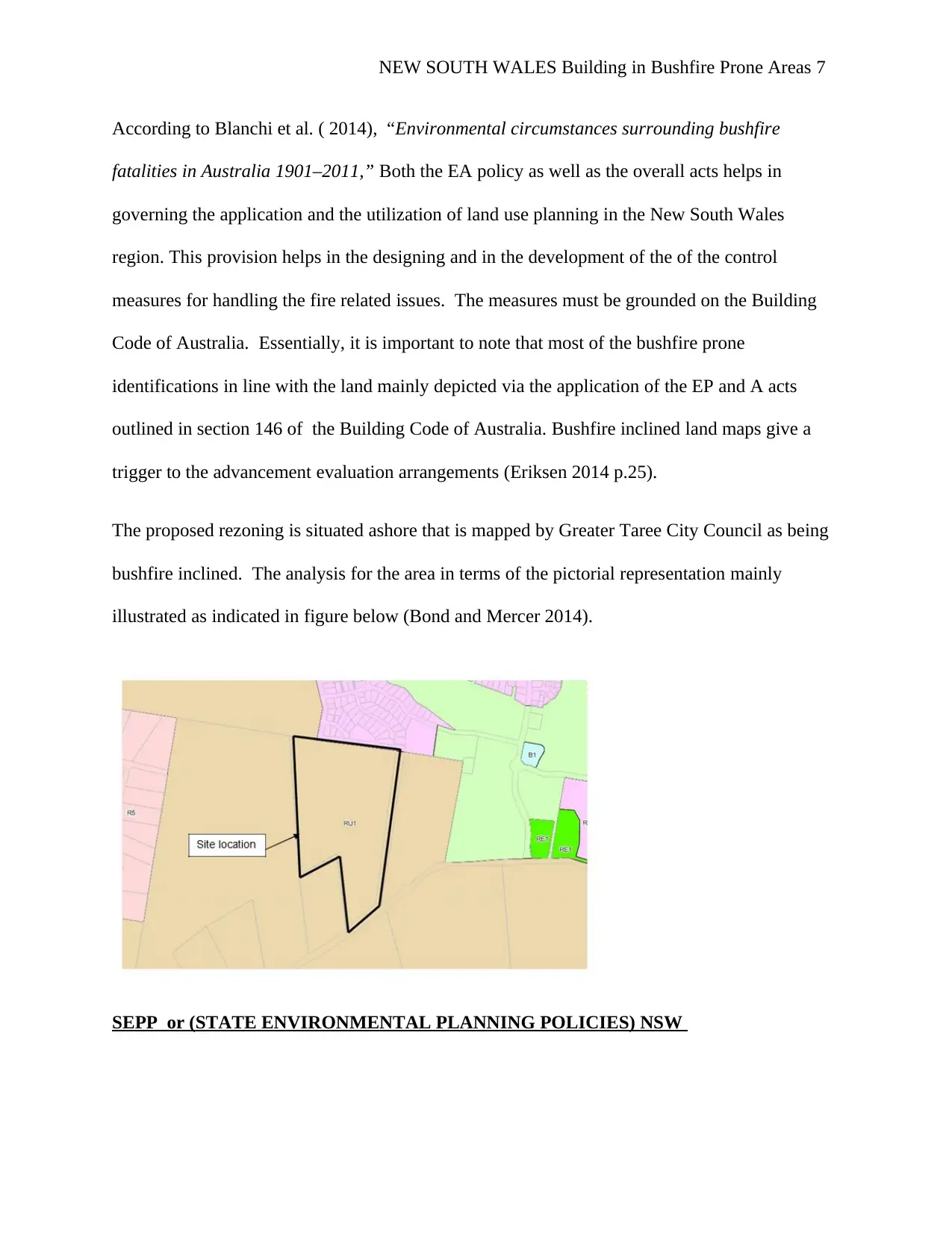
The proposed rezoning is situated ashore that is mapped by Greater Taree City Council as being
bushfire inclined. The analysis for the area in terms of the pictorial representation mainly
illustrated as indicated in figure below (Bond and Mercer 2014).
SEPP or (STATE ENVIRONMENTAL PLANNING POLICIES) NSW
According to Blanchi et al. ( 2014), “Environmental circumstances surrounding bushfire
fatalities in Australia 1901–2011,” Both the EA policy as well as the overall acts helps in
governing the application and the utilization of land use planning in the New South Wales
region. This provision helps in the designing and in the development of the of the control
measures for handling the fire related issues. The measures must be grounded on the Building
Code of Australia. Essentially, it is important to note that most of the bushfire prone
identifications in line with the land mainly depicted via the application of the EP and A acts
outlined in section 146 of the Building Code of Australia. Bushfire inclined land maps give a
trigger to the advancement evaluation arrangements (Eriksen 2014 p.25).
The proposed rezoning is situated ashore that is mapped by Greater Taree City Council as being
bushfire inclined. The analysis for the area in terms of the pictorial representation mainly
illustrated as indicated in figure below (Bond and Mercer 2014).
SEPP or (STATE ENVIRONMENTAL PLANNING POLICIES) NSW
Paraphrase This Document
Need a fresh take? Get an instant paraphrase of this document with our AI Paraphraser
NEW SOUTH WALES Building in Bushfire Prone Areas 8
Arranging and advancement in NSW is done under the Environmental Planning and Assessment
in line with the Act of 1979. Additionally, improvement appraisal arrangements, the Act likewise
accommodates the creation of Environmental Planning Instruments, which are authoritative
reports that manage arrive utilize and advancement. These arranging instruments are State
Environmental Planning Policies (SEPPs) which are regulated by the State Government, and
Local Environment Plans (LEPs) which are directed by neighborhood Councils. The Act
additionally accommodates open interest in arranging choices, among different arrangements. A
rundown of SEPPs and Deemed SEPPs (once in the past Regional Environmental Plans) is given
in the NSW Planning Portal (McLennan, Elliott and Wright 2014).
LEP (LOCAL ENVIRONMENTAL PLAN) NSW
Summary for the Bushfire Evaluation
The overall summary for the bushfire evaluation obtained from the overall evaluation (Gibbons
et al. 2018 p.12).
Building protection These are BAL – Flame Zone (FZ), BAL 40,
BAL 29, BAL 19 and BAL 12.5 AS3959 –
Construction of buildings in bushfire-prone areas.
The lowest level, BAL 12.5, has the longest APZ
distance while BAL – FZ has the shortest APZ
distance. These allow for varying levels of
building design and use of appropriate materials.
The minimum asset protection zones outlined in
the analysis above and depicted in Scheduled
NEW SOUTH WALES Building in Bushfire Prone Areas 9
attached are based on a BAL 29 construction
standard.
Future applications for dwelling construction
(Class 1, 2 & 3 buildings as identified by the
Building Code of Australia) for lots located on
bushfire prone land will be subject to a separate
application either under section 79BA of the
EP&A Act or as complying development under
the Codes SEPP.
Hazard management
The APZs are to be managed in accordance with
the RFS guidelines Standards for Asset Protection
Zones (RFS, 2005), with landscaping to comply
with Appendix 5 of PBP. APZs are to be confined
within the development lots to ensure ongoing
management of the APZ.
Access for firefighting operations Future residential development within the site
will be accessed via Pulpit Road in the north.
Access to Blackhead Road in the south will be
available for emergency vehicles only.
Table 3.2 outlines the performance criteria and
acceptable solutions for public roads within the
future subdivision design. Appendix 2 provides
further detail regarding the safety of Pulpit Road
⊘ This is a preview!⊘
Do you want full access?
Subscribe today to unlock all pages.
Trusted by 1+ million students worldwide
NEW SOUTH WALES Building in Bushfire Prone Areas 10
as the primary evacuation route (to address NSW
RFS additional information request).
4. Proposed Development
The proposed developments in the are mainly discussed in the various subsections as follows
4.1 SEPP Requirements of the Site
The state environmental management policies mainly tackled in this assessment in various
sections and this incorporates:
4.2 Building Materials
AS 3959-2009 is basically worried about enhancing the capacity of structures to more readily
withstand assault from bushfire in this way giving a proportion of assurance to the building
inhabitants and also to the building itself. Of hugeness to AS 3959-2009 was the distribution (in
2007) of the AS 1530.8 arrangement of gauges that set out strategies for test for building
materials, components of development and frameworks subjected to bushfire conditions. The
distribution of these models gives certainty to manufacturers and buyers that the utilization of
items that have been exhibited to meet particular test prerequisites will result in a more secure
building. The Standards additionally furnish makers with an institutionalized procedure and takes
into account reasonable and steady assessment of items.
4.3 Landscaping
Landscaping around a building has a great impact in the management of bushfire. This include
growing a well-managed vegetation or fence with help in the blocking of wind blowing which is
Paraphrase This Document
Need a fresh take? Get an instant paraphrase of this document with our AI Paraphraser
NEW SOUTH WALES Building in Bushfire Prone Areas 11
a major agent of fire spread. The vegetation also helps in the reduction of the intensity of heat
radiation which may reach the house. Such planning procedures are really beneficial in the
construction of houses in bushfire prone areas (Pham, Palaneeswaran and Stewart 2018 p.1276).
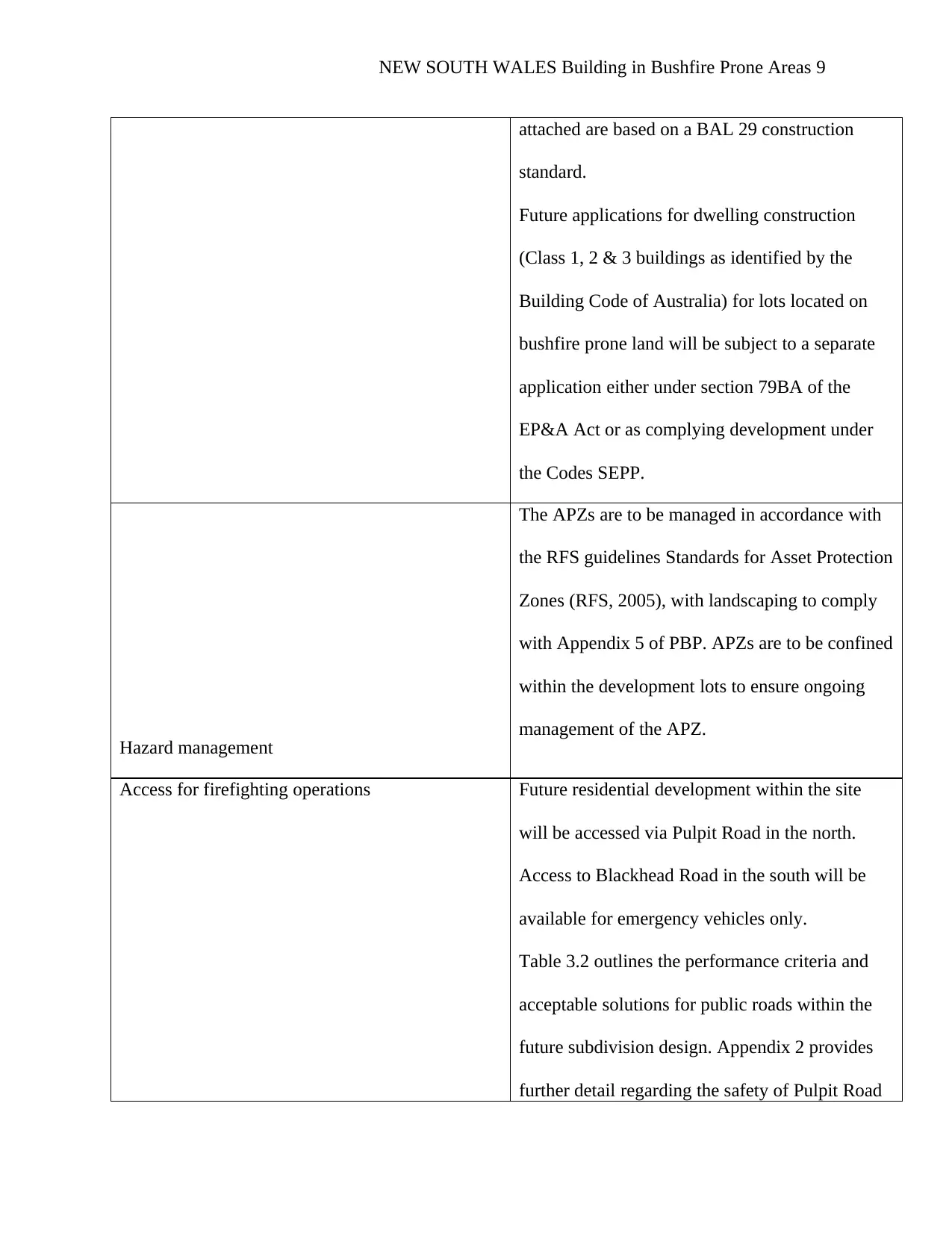
4.3.1 Plant Selection
Plant selection is a fundamental aspect and element which one must put into consideration when
appraising bushfire in line with the building and construction. Apparently, the area under study is
dominated with the evergreen plants and this makes it as an equatorial area. Some of the key
plants which can be planted in this area incorporate the Epiphytes, mahogany, greenheart and
rosewood as well as purple-heart. The aspect for plant selection mainly dominated via the
picture illustration as shown below (Mojtahedi, Newton and Von Meding 2017 p.1119).
a major agent of fire spread. The vegetation also helps in the reduction of the intensity of heat
radiation which may reach the house. Such planning procedures are really beneficial in the
construction of houses in bushfire prone areas (Pham, Palaneeswaran and Stewart 2018 p.1276).
4.3.1 Plant Selection
Plant selection is a fundamental aspect and element which one must put into consideration when
appraising bushfire in line with the building and construction. Apparently, the area under study is
dominated with the evergreen plants and this makes it as an equatorial area. Some of the key
plants which can be planted in this area incorporate the Epiphytes, mahogany, greenheart and
rosewood as well as purple-heart. The aspect for plant selection mainly dominated via the
picture illustration as shown below (Mojtahedi, Newton and Von Meding 2017 p.1119).
NEW SOUTH WALES Building in Bushfire Prone Areas 12
Figure Showing the Plants Selection and Section (Price 2018)
4.3.2 Pool
The overall analysis for the pool mainly demarcated as per the detailed diagram shown below
Figure Showing the Plants Selection and Section (Price 2018)
4.3.2 Pool
The overall analysis for the pool mainly demarcated as per the detailed diagram shown below
⊘ This is a preview!⊘
Do you want full access?
Subscribe today to unlock all pages.
Trusted by 1+ million students worldwide
1 out of 22
Related Documents


Your All-in-One AI-Powered Toolkit for Academic Success.
+13062052269
info@desklib.com
Available 24*7 on WhatsApp / Email
![[object Object]](/_next/static/media/star-bottom.7253800d.svg)
Unlock your academic potential
Copyright © 2020–2026 A2Z Services. All Rights Reserved. Developed and managed by ZUCOL.