Geog 205 Assignment 1: Photography and Urban Nature in Auckland
VerifiedAdded on 2023/04/22
|9
|1370
|65
Report
AI Summary
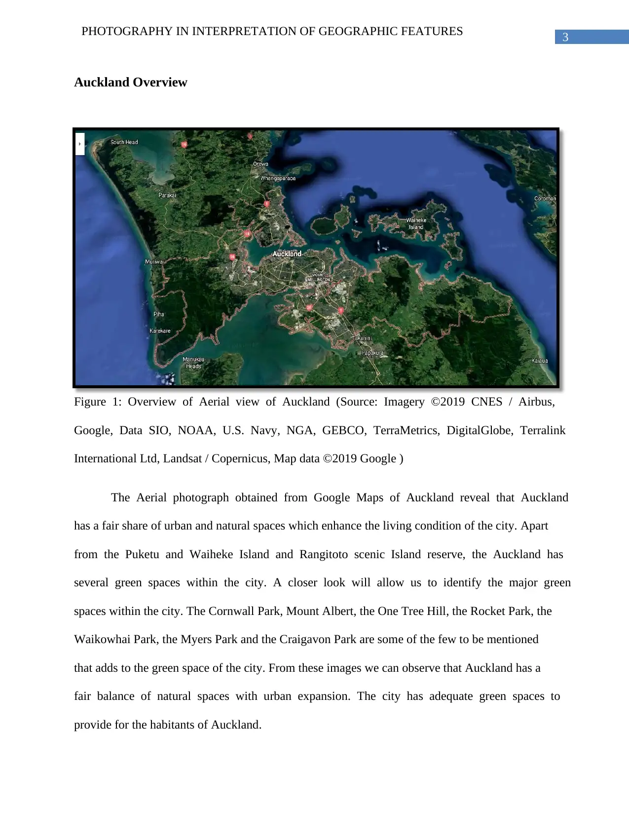
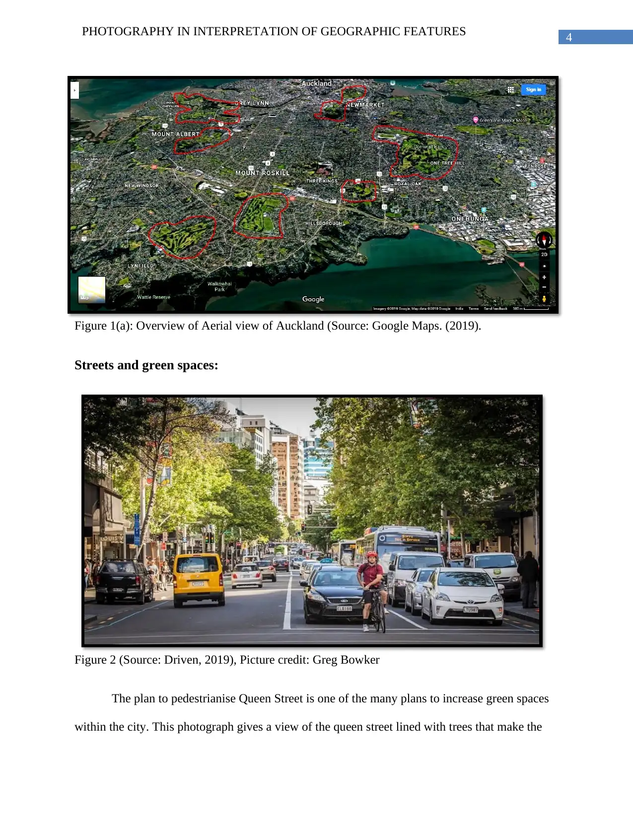
This report presents a photo essay that investigates the socio-natural spaces within Auckland, New Zealand. The essay utilizes photographic evidence to analyze the city's urban and green spaces, including parks, pedestrianized streets, and waterfront developments. The student examines how urban planning incorporates green spaces to enhance the living conditions and aesthetic value of the city. The essay includes an overview of Auckland's urban landscape, focusing on specific green spaces like Cornwall Park and Albert Park, and discusses initiatives like the pedestrianization of Queen Street and the Quay Street Transformation plan. Through the use of aerial and street-level photographs, the report highlights the balance between urban expansion and the preservation of natural environments, emphasizing the importance of green spaces for sustainable urban development and the well-being of Auckland's residents. The essay concludes that cities are indeed socio-natural spaces, and the balance between urban and natural environments is crucial for the sustainable growth of any urban settlement.

Running head: PHOTOGRAPHY IN INTERPRETATION OF GEOGRAPHIC FEATURES
PHOTOGRAPHY IN INTERPRETATION OF GEOGRAPHIC FEATURES
Name of the Student
Name of the University
Author Note
PHOTOGRAPHY IN INTERPRETATION OF GEOGRAPHIC FEATURES
Name of the Student
Name of the University
Author Note
Paraphrase This Document
Need a fresh take? Get an instant paraphrase of this document with our AI Paraphraser

2PHOTOGRAPHY IN INTERPRETATION OF GEOGRAPHIC FEATURES
Introduction:
As Hall (2009), describes the importance of photographs in evaluating human geography
by stating that it is a true record and is universally accepted and that a photographic survey is a
means to represent information in the truest form. While interpreting elements of human
geography Photographic evidence provides credible information that gives the researcher and the
audience an insight into the description of facts. With the advent of urban planning, the
necessities to have green spaces have been incorporated to provide aesthetic and environmental
value to an urban settlement. The cities of the modern days are fairly balanced as contrasted to
the older urban spheres. However with the recent rise of concerns regarding pollution and
healthy living, these cities are planning their extension with adequate green spaces to facilitate
the balance between urban and natural environments. It is no longer a rigid mandate that urban
settlements and natural spaces are divided with rigid boundary lines. Modern cities are now
developing their settlement pattern in a way that allows sustainable growth with adequate green
spaces and parks and fields. This paper will try to evaluate the concept of socio-natural spaces
with reference to Auckland, New Zealand with the help of photographic evidence.

3PHOTOGRAPHY IN INTERPRETATION OF GEOGRAPHIC FEATURES
Auckland Overview
Figure 1: Overview of Aerial view of Auckland (Source: Imagery ©2019 CNES / Airbus,
Google, Data SIO, NOAA, U.S. Navy, NGA, GEBCO, TerraMetrics, DigitalGlobe, Terralink
International Ltd, Landsat / Copernicus, Map data ©2019 Google )
The Aerial photograph obtained from Google Maps of Auckland reveal that Auckland
has a fair share of urban and natural spaces which enhance the living condition of the city. Apart
from the Puketu and Waiheke Island and Rangitoto scenic Island reserve, the Auckland has
several green spaces within the city. A closer look will allow us to identify the major green
spaces within the city. The Cornwall Park, Mount Albert, the One Tree Hill, the Rocket Park, the
Waikowhai Park, the Myers Park and the Craigavon Park are some of the few to be mentioned
that adds to the green space of the city. From these images we can observe that Auckland has a
fair balance of natural spaces with urban expansion. The city has adequate green spaces to
provide for the habitants of Auckland.
⊘ This is a preview!⊘
Do you want full access?
Subscribe today to unlock all pages.

Trusted by 1+ million students worldwide

4PHOTOGRAPHY IN INTERPRETATION OF GEOGRAPHIC FEATURES
Figure 1(a): Overview of Aerial view of Auckland (Source: Google Maps. (2019).
Streets and green spaces:
Figure 2 (Source: Driven, 2019), Picture credit: Greg Bowker
The plan to pedestrianise Queen Street is one of the many plans to increase green spaces
within the city. This photograph gives a view of the queen street lined with trees that make the
Paraphrase This Document
Need a fresh take? Get an instant paraphrase of this document with our AI Paraphraser

5PHOTOGRAPHY IN INTERPRETATION OF GEOGRAPHIC FEATURES
road visually relaxing and restricting cars in the street will allow less pollutions and sustainable
growth of green sprawls within the city which is exceptionally necessary to preserve the
existence of greener patches within the central city. A walk or bike ride would enhance the
aesthetic as well as the healthy aspect of the town. Similar other approaches would allow the
sustenance of the urban nature within the streets. The plan to pedestrianise the Queen was
included in the city plan in 2012. This enhanced the nature urban interaction in Queen Street.
Quay Street
Figure 3: (Source: Ourauckland, 2019).
The Quay Street Transformation plan undertaken by the City Center Master Plan by the
Auckland City council allows for the up gradation of the status of the street and was included as
an Initiative of Downtown frame work. Being a harbor edge Street, this location is being
renovated to increase the natural space along with transforming it into a pedestrian and meeting

6PHOTOGRAPHY IN INTERPRETATION OF GEOGRAPHIC FEATURES
point, rather than being a busy street. This Photo here gives an insight into urban nature
interaction at Quay Street and reflects the way the street is being used as an escape from the
urban busy streets by allowing pedestrians to take a detour through a relaxing walking
experience. This street is also one of the many instances of nature urban existence in Auckland.
Urban nature Walks
Albert Park
Albert Park is one of the nature walks situated within the city. This park allows for the
natural walk trails and allows visitors to exercise and relax their fatigue amidst nature. This is
one of the Public Parks and is bounded by the Wellesley Street, the Princes Street, Bowen
Avenue and Kitchener Street. This park is a fine example of the socio-natural spaces present in
the city. This Park also adds to the environmental asset of the city by curbing down pollution and
enhancing the carrying capacity of Auckland.
Figure 4: (Source: http://ourauckland.aucklandcouncil.govt.nz/articles/news/2018/1/walks-for-
every-auckland-landscape/)
⊘ This is a preview!⊘
Do you want full access?
Subscribe today to unlock all pages.

Trusted by 1+ million students worldwide

7PHOTOGRAPHY IN INTERPRETATION OF GEOGRAPHIC FEATURES
Cornwall Park
Figure 5: Source (Cornwall, 2019)
The Cornwall Park is one of the most loved parks of the town. With a sprawling
extension of 425 acres of vegetative cover, it gives a unique experience to the city dwellers. The
Cornwall Park allows its citizens to enjoy outdoor activities and strolling all round the year and
offers an exquisite example of urban nature amalgamation. The park offers walking trails and is a
natural retreat within the heart of the city.
Conclusion:
Thus from the above photographic evidences, it gives a clear picture about the urban
nature expanses of the city of Auckland which offers great rehabilitation to the public and
Paraphrase This Document
Need a fresh take? Get an instant paraphrase of this document with our AI Paraphraser

8PHOTOGRAPHY IN INTERPRETATION OF GEOGRAPHIC FEATURES
enhances the aesthetic value of the Auckland. Being located off the Bay, Auckland enjoys scenic
beauty apart from these parks within the city. The extension of the city includes the islands of
Puketutu, Rongitoto, Motutapu and Waiheke Islands, which add to the natural space of the city
but in an extended form. However the parks of the city have been developed with time and have
evolved with the growing city. The modifications of the park came with the urban growth and
with the Auckland Downtown Framework by the city Council; more instances of simultaneous
growth of nature and urban spaces have taken place. Thus we can conclude that cities are indeed
socio natural spaces and the balance between the two spheres is essential for a sustainable
growth of any urban settlement.

9PHOTOGRAPHY IN INTERPRETATION OF GEOGRAPHIC FEATURES
References
Bikeauckland. (2019). Retrieved from https://www.bikeauckland.org.nz/wp-
content/uploads/2014/09/20140924-Queens-Wharf-turning-restriction-media-statement-
final.pdf
Cornwall Park. (2019). Cornwall Park: Auckland, New Zealand. Retrieved from
http://cornwallpark.co.nz/
Cornwall. (2019). Retrieved from http://cornwallpark.co.nz/)
Driven. (2019). No cars on Queen St: the new plan for Auckland central city. Retrieved from
https://www.driven.co.nz/news/news/no-cars-on-queen-st-the-new-plan-for-auckland-
central-city/
Google Maps. (2019). Google Maps. Retrieved from https://maps.google.com/ Imagery ©2019
CNES / Airbus, Google, Data SIO, NOAA, U.S. Navy, NGA, GEBCO, TerraMetrics,
DigitalGlobe, Terralink International Ltd, Landsat / Copernicus, Map data ©2019 Google
Hall, T. (2009). The camera never lies? Photographic research methods in human
geography. Journal of Geography in Higher Education, 33(3), 453-462.
OurAuckland. (2019). Auckland News and Events. Retrieved from
http://ourauckland.aucklandcouncil.govt.nz/
Ourauckland. (2019). Retrieved from
http://ourauckland.aucklandcouncil.govt.nz/media/23068/1803-quay-street_render-02-
for-web.jpg
⊘ This is a preview!⊘
Do you want full access?
Subscribe today to unlock all pages.

Trusted by 1+ million students worldwide
1 out of 9

Your All-in-One AI-Powered Toolkit for Academic Success.
+13062052269
info@desklib.com
Available 24*7 on WhatsApp / Email
Unlock your academic potential
Copyright © 2020–2025 A2Z Services. All Rights Reserved. Developed and managed by ZUCOL.