1005HSL People and Places in Service Industries: Brisbane Field Trip
VerifiedAdded on 2020/04/07
|9
|2444
|53
Homework Assignment
AI Summary
This assignment is a self-directed field trip around Brisbane City Centre, designed to analyze various aspects of the city's service industries, urban planning, and retail landscape. The student is tasked with visiting key locations, including the Queen Street Mall, Brisbane River, and Botanic Gardens, to observe and document retail outlets, urban renewal projects, and examples of rejuvenation strategies. The assignment requires the student to identify global brands, analyze signage, and assess the influence of luxury brands on urban renewal. Furthermore, the student must consider inclusivity and accessibility, identify stakeholder groups in development projects, and analyze the city's 'sense of place.' The observations and data collected during the field trip will be used to provide examples in an individual essay, emphasizing the practical application of theoretical concepts learned in class, such as Bitner's Servicescapes theory and urban renewal strategies. The student is required to complete the field trip before a Week 11 workshop and submit their data collection record in Week 12.
1
1005HSL People and Places in the Service Industries
Week 10: Fieldwork around Brisbane City Centre
You should by now have completed the reading and exercises in the Task sheet for Week 10.
The field trip will refer specifically to pages 42, 43, 44, 64, 65, 68 and 114 to 124 of the Brisbane City
Master Plan 2014.
The field trip is self-directed. This means you will NOT be accompanied by any member of the teaching
team. This also means you have the flexibility to go on the field trip any day that suits you best.
Conducting the field trip virtually via Google Earth and Google Street View is not permitted. Because,
a virtual field trip will not help you to sense/feel and may, therefore not help you with your essay. Also,
answering some of the questions below can be a frustrating process given the fact that we also discuss
the intangible aspects of people and places. Additionally, each student must do all parts of the field
trip so you can appreciate the plan and how it links with the theory studied in class (this too will help
you with your essay).
The field trip must be completed prior to the tutorial/workshop in Week 11.
The field trip should take approximately 2 hours to complete. Dress for a walk in the open air with
comfortable clothing and shoes, take/buy a bottle of water and consider wearing a hat, sunglasses and
sunscreen. You will need to print and take this Field Trip Worksheet and a pencil or pen to record
answers to questions. Use Google Maps on your mobile if you need a back-up location finder.
Be aware of your safety: travel in a group of 2-4 people, look where you are walking, do not
stop in the middle of a footpath or roadway and cause inconvenience to other people, take care
crossing roads. It is recommended that you do not take laptops and be aware of your personal
possessions. Check your time and keep moving.
The field trip must be completed prior to the Week 11 Workshop.
This exercise is worth MARKS. You will use this observation research data to give examples in your
individual essay. As with all research, you need to keep your data collection record and you are
required to hand it in during the Week 12 class. If you do not hand this in your marks will not be as
high as they could be.
----------------------------------------------------------------------------------------------------------------------------------------------
Please start here. Begin at entrance to MYER department store on the Queen Street Mall.
Walk west towards the top of the Mall and the Brisbane River.
1. What type of retail outlets do you see? Any global brands? What would stores tourists be attracted
to? Note: buildings, stores, views, etc
Queen Street Shopping mall
Myer Brisbane Centre
Paraphrase This Document
Need a fresh take? Get an instant paraphrase of this document with our AI Paraphraser
2
2. Locate a sign towards the right hand side of the Mall where the Mall meets George Street. What is
significant about this sign? Who would use it?
Cross George Street and continue toward the Brisbane River.
3. Note the building on your left. What is its name? What was its original purpose? What is its purpose
today?
Treasury Casino & Hotel Brisbane. Originally served as a government building.
4. Note the construction on your right. What is it? Of which early semester theory is this an example?
Identify the theory and explain the connection between the theory and the construction.
Quit Gardens Point Campus
When you reach the junction of the Mall, William Street and the Victoria Bridge, cross William
Street, stay to the left and proceed to the North Quay Ferry Terminal where the City Cats berth.
5. Look all around and comment on what you see.
Note: buildings on the opposite bank (along the river to the south), what is opposite the ferry terminal?
Queen Wharf Road, Bicentennial Bikeway, Riverside Expressway, The Commissariat Store Museum. Brisbane city
county council
6. Look carefully along this side of the river bank to the south. What current structures do you see?
What proposed development has the Brisbane City Council approved? What is its name and what
buildings will be included in this development? Particularly, what will be built along this river bank?
3
Return up the North Quay ramp until you come to the cliff face. Stop here for a moment.
7. Ahead of you, you will see a notice board. What is it showing you? It uses a familiar term learnt in
Class, “Precinct”, what does this mean in general? Identify the characteristic of this precinct.
It means the perceived boundary limits or a policy segmentation or a location or place. Its characteristics include
boundary, physical location and protection (Gregory, 2015)
8. Look left, what do you see? You should be thinking ramp and elevator. Of which early semester
theory is this an example? Identify the theory and explain the connection between the theory and the
construction.
Safety in riverside construction is important. Developing buildings along locations where people operate calls for
safety
Walk up the ramp and go up in the elevator. Cross back over William Street and turn right.
You will cross over Elizabeth Street walking past the Queens Gardens and another historic
building.
9. What is the statue on the corner? What is the current use of the historic building behind Queens
Gardens?
Treasury
10. What other historic buildings can you see across the road?
⊘ This is a preview!⊘
Do you want full access?
Subscribe today to unlock all pages.
Trusted by 1+ million students worldwide
4
Brisbane Square Library,
Immediately after the historic building, turn left and walk through Stephens Lane to George
Street and cross over the road. Keep walking south toward QUT until you reach Alice Street.
11. As you make your way past the large Queens Wharf construction site, identify the possible stakeholder
groups involved in this development. What conflicts could arise between the parties?
Ministry of home affairs, local government and the business community. Conflict about the prioritization of the
new development could arise. Issues about resources and space manipulation could also influence the choices
made. Queen Wharf Road, Bicentennial Bikeway, Riverside Expressway, The Commissariat Store Museum.
Brisbane city county council
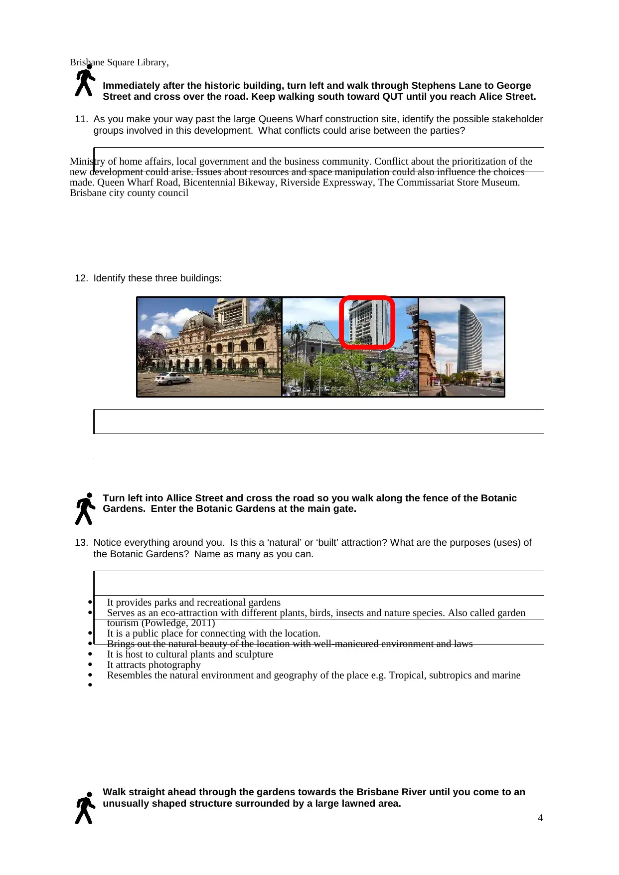
12. Identify these three buildings:
Turn left into Allice Street and cross the road so you walk along the fence of the Botanic
Gardens. Enter the Botanic Gardens at the main gate.
13. Notice everything around you. Is this a ‘natural’ or ‘built’ attraction? What are the purposes (uses) of
the Botanic Gardens? Name as many as you can.
It provides parks and recreational gardens
Serves as an eco-attraction with different plants, birds, insects and nature species. Also called garden
tourism (Powledge, 2011)
It is a public place for connecting with the location.
Brings out the natural beauty of the location with well-manicured environment and laws
It is host to cultural plants and sculpture
It attracts photography
Resembles the natural environment and geography of the place e.g. Tropical, subtropics and marine
Walk straight ahead through the gardens towards the Brisbane River until you come to an
unusually shaped structure surrounded by a large lawned area.
Brisbane Square Library,
Immediately after the historic building, turn left and walk through Stephens Lane to George
Street and cross over the road. Keep walking south toward QUT until you reach Alice Street.
11. As you make your way past the large Queens Wharf construction site, identify the possible stakeholder
groups involved in this development. What conflicts could arise between the parties?
Ministry of home affairs, local government and the business community. Conflict about the prioritization of the
new development could arise. Issues about resources and space manipulation could also influence the choices
made. Queen Wharf Road, Bicentennial Bikeway, Riverside Expressway, The Commissariat Store Museum.
Brisbane city county council
12. Identify these three buildings:
Turn left into Allice Street and cross the road so you walk along the fence of the Botanic
Gardens. Enter the Botanic Gardens at the main gate.
13. Notice everything around you. Is this a ‘natural’ or ‘built’ attraction? What are the purposes (uses) of
the Botanic Gardens? Name as many as you can.
It provides parks and recreational gardens
Serves as an eco-attraction with different plants, birds, insects and nature species. Also called garden
tourism (Powledge, 2011)
It is a public place for connecting with the location.
Brings out the natural beauty of the location with well-manicured environment and laws
It is host to cultural plants and sculpture
It attracts photography
Resembles the natural environment and geography of the place e.g. Tropical, subtropics and marine
Walk straight ahead through the gardens towards the Brisbane River until you come to an
unusually shaped structure surrounded by a large lawned area.
Paraphrase This Document
Need a fresh take? Get an instant paraphrase of this document with our AI Paraphraser
5
14. What is this structure? Of which of the six Rejuvenation Strategies (Week 7 lecture) is this an
example?
Walk back towards the city. Follow the path along the river, across from which you can see
the Kangaroo Point cliffs, and further east, the Story Bridge.
15. As you walk along, be observant. Make a note of the signs, structures and views you can see. Find
examples of Bitner’s (1992) theory about Servicescapes: Ambient Conditions, Function/Space, and
Signs, Symbols and Artifacts.
16. What evidence have you seen to remind you of inclusivity, “accessibility”?
Inclusivity ensures that the larger community is part of the project (Tom & Fredric, 2017). Cultural diversity
ensures that the city has recognition for global culture. Evidence includes restaurants, and amenities for all age
groups. Accessibility makes event centers reachable through roads, airport, underground transit systems and ports.
When you reach the exit to the Botanical Gardens on the corner of Alice and Edward Streets,
head north along Edward Street, toward the Queen Street Mall. Make a note of the building at
No. 53 Edward Street (you will need this later).
17. How do you find walking along Edward Street? Is it easy and comfortable? Do you feel safe?
Note: Observe footpaths, greeneries, buildings, people, etc
18. When you cross Elizabeth Street, what international luxury brands outlets do you see?
6
19. How do these outlets influence the urban renewal plan for Edward Street?
Global landmarks are attractions because they influence recognition of a place, these are also important for
navigation (Spirou, 2011). The constructions have economic benefits and they enhance the social environment
because of recreation and educational locations.
20. What is the nature of the property at 201 Edward Street? Is it the same as the property at 53 Edward
Street? What did you notice was the difference in the style of the buildings?
21. Macarthur Chambers and The Bostonian Apartments are examples of which theoretical concept of
Urban renewal?
Comprehensive planning includes housing under Social Spatial integration. (Hall & Page, 2014). This includes
rehabilitation of public utilities, urban renewal and public housing units. This creates city dwellings and is
important in management of coexistence.
Turn around and go back along Edward Street and turn right into Elizabeth Street and head
west toward Albert Street.
22. Is there any difference between the ‘sense of place’ on Edward Street and Elizabeth Street?
When you reach the corner of Elizabeth and Alberts Streets. Look both ways and notice the
businesses around you.
23. Is there much outdoor space for dining and entertainment on the street currently? If so, where?
⊘ This is a preview!⊘
Do you want full access?
Subscribe today to unlock all pages.
Trusted by 1+ million students worldwide
7
24. Who currently visits Albert Street?
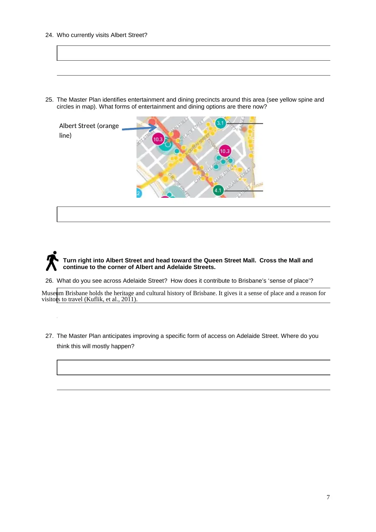
25. The Master Plan identifies entertainment and dining precincts around this area (see yellow spine and
circles in map). What forms of entertainment and dining options are there now?
Albert Street (orange
line)
Turn right into Albert Street and head toward the Queen Street Mall. Cross the Mall and
continue to the corner of Albert and Adelaide Streets.
26. What do you see across Adelaide Street? How does it contribute to Brisbane’s ‘sense of place’?
Museum Brisbane holds the heritage and cultural history of Brisbane. It gives it a sense of place and a reason for
visitors to travel (Kuflik, et al., 2011).
27. The Master Plan anticipates improving a specific form of access on Adelaide Street. Where do you
think this will mostly happen?
24. Who currently visits Albert Street?
25. The Master Plan identifies entertainment and dining precincts around this area (see yellow spine and
circles in map). What forms of entertainment and dining options are there now?
Albert Street (orange
line)
Turn right into Albert Street and head toward the Queen Street Mall. Cross the Mall and
continue to the corner of Albert and Adelaide Streets.
26. What do you see across Adelaide Street? How does it contribute to Brisbane’s ‘sense of place’?
Museum Brisbane holds the heritage and cultural history of Brisbane. It gives it a sense of place and a reason for
visitors to travel (Kuflik, et al., 2011).
27. The Master Plan anticipates improving a specific form of access on Adelaide Street. Where do you
think this will mostly happen?
Paraphrase This Document
Need a fresh take? Get an instant paraphrase of this document with our AI Paraphraser
8
Return to the Queen Street Mall
28. What would you say is the current core attractions on the Queen Street Mall for tourists and visitors?
Brisbane Botanic Gardens
Museum and cultural center
Queen Street Mall
Citycat
Bridges
Hotels
Restaurants
29. Can you find evidence of another Rejuvenation Strategy on the side of a restaurant? What is it?
Parking and shared space strategy for visitors (Alpopi & Manole, 2013)
30. Walk back towards the MYER Centre. Can you find another example of the Rejuvenation Strategy:
Events: Community? What is it? A clue, it is similar to something you saw in the Botanical Gardens.
The Travelex
** the end **
9
1. References
Alpopi, C., & Manole, C. (2013). Integrated and urban regeneration-solution for cities revitalize. Procedia
Economics and Finance, 178-185.
Gregory, J. J. (2015). Creative industries and urban regeneration-The Maboneng precinct, Johannesberg. Local
Economy: The Journal of the local economy policy unit, 158-171.
Hall, C., & Page, S. J. (2014). The geography of toursm and recreation: . Environment, place and space.
Kuflik, T., Stock, O., Zancanaro, M., Gorfinkel, A., Jbara, S., Kats, S., & Kashtan, N. (2011). A visitors guide in an
active museum: Presentations, commmunications and refelction. Journal of Computing and Cultural
Heritage, 11.
Powledge, F. (2011). The evolving role of botanical gardens: Hegdes against extinction, showcases for botany?
BioScience, 61(10), 743-749.
Spirou, C. (2011). Urban tourism and urban change: Cities in a global economy. Rouledge.
Tom, G., & Fredric, D. (2017). Urban tourism: the growing role of VFR and immigration. Journal of tourism
futures. Retrieved September 18, 2017, from http://www.emeraldinsight.com/doi/full/10.1108/JTF-10-
2016-0036
⊘ This is a preview!⊘
Do you want full access?
Subscribe today to unlock all pages.
Trusted by 1+ million students worldwide
1 out of 9
Your All-in-One AI-Powered Toolkit for Academic Success.
+13062052269
info@desklib.com
Available 24*7 on WhatsApp / Email
![[object Object]](/_next/static/media/star-bottom.7253800d.svg)
Unlock your academic potential
Copyright © 2020–2026 A2Z Services. All Rights Reserved. Developed and managed by ZUCOL.