CIV4ID Infrastructure Design: Melbourne Traffic Analysis Report
VerifiedAdded on 2022/11/07
|11
|2442
|125
Report
AI Summary
This report, prepared for the CIV4ID Infrastructure Design course, presents a traffic impact analysis conducted in Melbourne, Australia, specifically focusing on an area bounded by Darebin creek, Kingsway drive, and Preston Cemetery. The study utilizes SIDRA software to model and analyze traffic patterns, assess intersection performance, and evaluate the potential impacts of a proposed development. The report examines traffic volumes, identifies areas of congestion, and proposes land use recommendations based on traffic flow data, including suggestions for parking provisions and service deliveries. The analysis considers the effects of heavy vehicles, pedestrian movements, and the potential for new routes to alleviate congestion. The primary goal is to provide insights and solutions to improve traffic flow and enhance the livability of the area, ultimately informing decisions regarding infrastructure design and land use planning. The report also includes an executive summary, table of contents, introduction, design, results, discussions, conclusion, and references.
1Running head: CIV4ID INFRASTRUCTURE DESIGN
CIV4ID Infrastructure Design
[Name]
[Institutional Affiliation]
CIV4ID Infrastructure Design
[Name]
[Institutional Affiliation]
Paraphrase This Document
Need a fresh take? Get an instant paraphrase of this document with our AI Paraphraser
2CIV4ID INFRASTRUCTURE DESIGN
Executive Summary
With the economic advancements, many people continue to own private cars, this
has been the cause for traffic congestion in many towns, cities and urban centres. In fact, as
years go by, traffic congestion continue to remain a threat that many people in the leadership
position continue to grapple with. The statistics are out there carried out in the United States,
that registered vehicle numbers have grown exponentially, that in 1990 the number of
vehicles were less than 200 million and presently there are more than 250 million vehicles,
which is a 25% increase over the years (US Department of Transportation, 2019). Even as
this happens, the development of the capacity of the network is not directly proportionate to
the rising number of automobiles in the highways. Again the evidence of this is a study done
in the United States by the Texas A&M Transportation Institute and Inrix on the Urban
Mobility scorecard, indicates that the residents living Washington D.C. spend up to 82hours
per annum as a result of slow traffic during the rush hour times, this they admit, is the most
hours spent in traffic in the United States. This is followed by the Los Angeles, San
Francisco, and New York. In the year 2014, each commuter in Washington D.C., Maryland,
and Virginia, was said to have lost 82 hours. This was translated to a yearly congestion cost
of around $1,834 per commuter, for the 204.4 million commuters, which is around $4.6
billion (Litman, 2015).
Globally, according to Inrix Bogota is the world leader in the hours lost in traffic,
followed by Rome, Dublin and Moscow and the least among the cities where the survey was
carried out, is Wichita, in Kansas city (INRIX, 2018). This paper or research will be concern
with conducting the traffic analysis in Melbourne in Australia, at a place bounded by Darebin
creek, Kingsway drive, and Preston Cemetery. On the analysis, this paper also probes the
impacts of the traffic is having on the surrounding and recommend what measures needs to
be taken to solve any traffic menace there might be. Using the SIDRA software, analysing the
capacity will be possible and the evaluation of the impacts of the adjacent intersections at the
site of study. With the software, there shall be a possibility is determining the parking slots
availability from the land use.
3CIV4ID INFRASTRUCTURE DESIGN
Table of Contents
Title Page ………………………………………………………………………………… 1
Executive Summary ...……………………………………………………………………. 2
Contents ……………………………………………………………………………………3
Introduction ………………………………………………………………………………..4
Design …………………………………………………………………………………….….6
Results and Discussions ………………………………………………………………….…7
Conclusion ………………………………………………………………………………….10
References..........................................................................................................................................11
⊘ This is a preview!⊘
Do you want full access?
Subscribe today to unlock all pages.
Trusted by 1+ million students worldwide
4CIV4ID INFRASTRUCTURE DESIGN
Introduction
In the past, the major concerns of modelling have been the forward movement of
the vehicles than the spread of queues that are in the intersections. This form of modelling is
important as well, but when there’s no modelling of the capacity-reducing that reduces the
blockages of the vehicles departing by the queues that are downstream, and those of the
capacity constraints of the oversaturated conditions can’t give a sufficient model of a network
that has a higher demand of traffic of these days. The conventional model of the network
analysis is link-based, this means that they represent the lanes that are grouped, where the
traffic condition for each lane are combined and would be lost in the more combined traffic
units. There is an importance in estimating the capacity, the flow, and the queue of the lanes
while analysing the performance of an intersection, this is more essential in the modelling of
the close intersection. The lane capacities, queues and flows for the downstream and
upstream could depend on each other places where there are closely spaced intersections.
The land use parameters can be viewed in the transportation angle, where it
affects the use of land immensely. When a decision is made to change something will
eventually affect the use of another. That is why it is important to link up and coordinate the
land use and transportation planning choices for them to complement one another rather than
contradict the other. This collaboration also ensures that the decision of transport planning
and the objectives of the land use planning are in support of the goals that are achievable to
better the environment. On this area where we are having the study carried through, there are
major, medium, and smaller roads. These roads ensure there’s access to homes and
institutions or social amenities in the area. The design process is to ensure there’s a seamless
flow of traffic, and that no one is affected by congestion whatsoever. The volume of
movement study that is designed by SIDRA ensures there’s even an analysis of the volume of
the masses on the road, and looking at the map of the area, it is visible the kind of houses in
that region. Still viewing the map and knowing how the traffic flows, it is possible to design
packing for the public. Still on the design, SIDRA allows us to see the traffic areas, the
direction of heavy traffic, this in collaboration with the map (which shall be retrieved from
Google), see figure 1, shall be expressed the office areas and the so the inroads into people’s
homes and those from the offices and other commercial areas, shall bring into the picture the
ease of joining the main roads. SIDRA allows us to see the vehicle movement and be able to
determine the areas with the heavy traffic
Paraphrase This Document
Need a fresh take? Get an instant paraphrase of this document with our AI Paraphraser
5CIV4ID INFRASTRUCTURE DESIGN
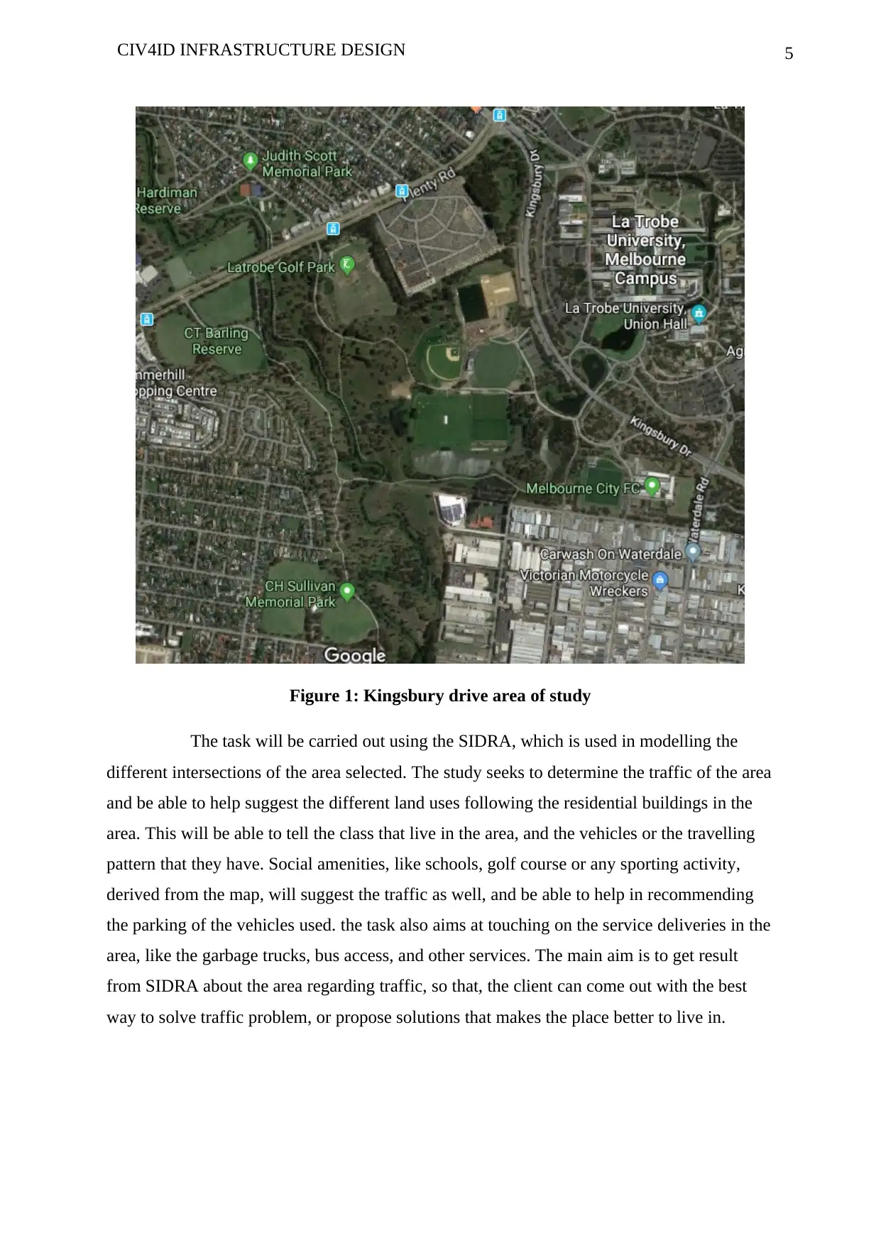
Figure 1: Kingsbury drive area of study
The task will be carried out using the SIDRA, which is used in modelling the
different intersections of the area selected. The study seeks to determine the traffic of the area
and be able to help suggest the different land uses following the residential buildings in the
area. This will be able to tell the class that live in the area, and the vehicles or the travelling
pattern that they have. Social amenities, like schools, golf course or any sporting activity,
derived from the map, will suggest the traffic as well, and be able to help in recommending
the parking of the vehicles used. the task also aims at touching on the service deliveries in the
area, like the garbage trucks, bus access, and other services. The main aim is to get result
from SIDRA about the area regarding traffic, so that, the client can come out with the best
way to solve traffic problem, or propose solutions that makes the place better to live in.
6CIV4ID INFRASTRUCTURE DESIGN
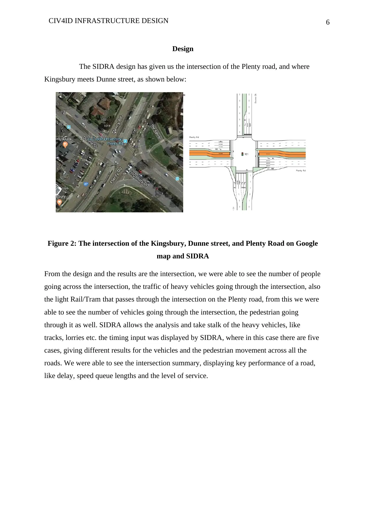
Design
The SIDRA design has given us the intersection of the Plenty road, and where
Kingsbury meets Dunne street, as shown below:
Figure 2: The intersection of the Kingsbury, Dunne street, and Plenty Road on Google
map and SIDRA
From the design and the results are the intersection, we were able to see the number of people
going across the intersection, the traffic of heavy vehicles going through the intersection, also
the light Rail/Tram that passes through the intersection on the Plenty road, from this we were
able to see the number of vehicles going through the intersection, the pedestrian going
through it as well. SIDRA allows the analysis and take stalk of the heavy vehicles, like
tracks, lorries etc. the timing input was displayed by SIDRA, where in this case there are five
cases, giving different results for the vehicles and the pedestrian movement across all the
roads. We were able to see the intersection summary, displaying key performance of a road,
like delay, speed queue lengths and the level of service.
⊘ This is a preview!⊘
Do you want full access?
Subscribe today to unlock all pages.
Trusted by 1+ million students worldwide
7CIV4ID INFRASTRUCTURE DESIGN
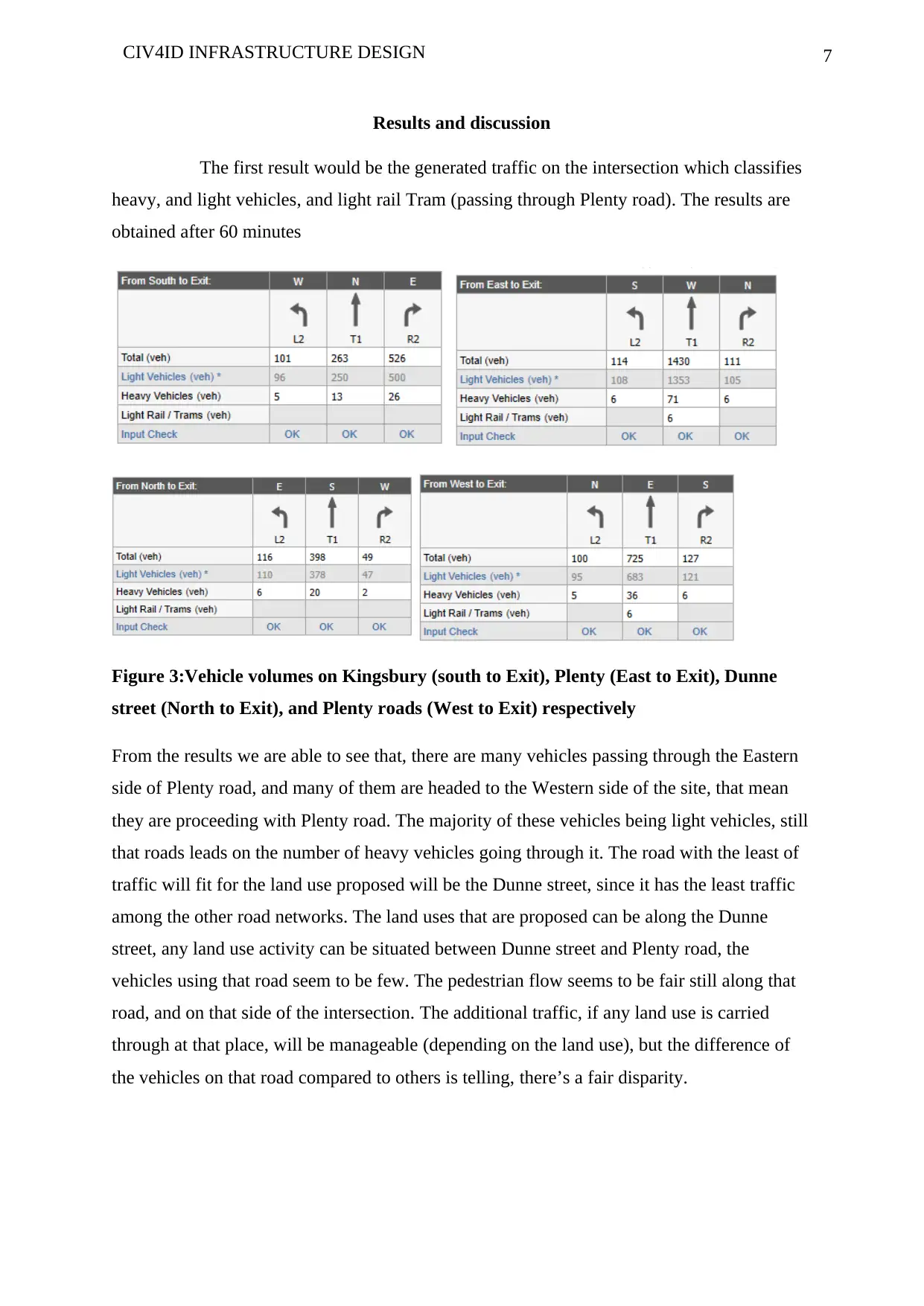
Results and discussion
The first result would be the generated traffic on the intersection which classifies
heavy, and light vehicles, and light rail Tram (passing through Plenty road). The results are
obtained after 60 minutes
Figure 3:Vehicle volumes on Kingsbury (south to Exit), Plenty (East to Exit), Dunne
street (North to Exit), and Plenty roads (West to Exit) respectively
From the results we are able to see that, there are many vehicles passing through the Eastern
side of Plenty road, and many of them are headed to the Western side of the site, that mean
they are proceeding with Plenty road. The majority of these vehicles being light vehicles, still
that roads leads on the number of heavy vehicles going through it. The road with the least of
traffic will fit for the land use proposed will be the Dunne street, since it has the least traffic
among the other road networks. The land uses that are proposed can be along the Dunne
street, any land use activity can be situated between Dunne street and Plenty road, the
vehicles using that road seem to be few. The pedestrian flow seems to be fair still along that
road, and on that side of the intersection. The additional traffic, if any land use is carried
through at that place, will be manageable (depending on the land use), but the difference of
the vehicles on that road compared to others is telling, there’s a fair disparity.
Paraphrase This Document
Need a fresh take? Get an instant paraphrase of this document with our AI Paraphraser
8CIV4ID INFRASTRUCTURE DESIGN
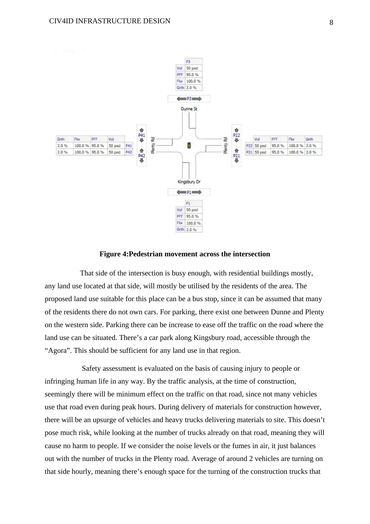
Figure 4:Pedestrian movement across the intersection
That side of the intersection is busy enough, with residential buildings mostly,
any land use located at that side, will mostly be utilised by the residents of the area. The
proposed land use suitable for this place can be a bus stop, since it can be assumed that many
of the residents there do not own cars. For parking, there exist one between Dunne and Plenty
on the western side. Parking there can be increase to ease off the traffic on the road where the
land use can be situated. There’s a car park along Kingsbury road, accessible through the
“Agora”. This should be sufficient for any land use in that region.
Safety assessment is evaluated on the basis of causing injury to people or
infringing human life in any way. By the traffic analysis, at the time of construction,
seemingly there will be minimum effect on the traffic on that road, since not many vehicles
use that road even during peak hours. During delivery of materials for construction however,
there will be an upsurge of vehicles and heavy trucks delivering materials to site. This doesn’t
pose much risk, while looking at the number of trucks already on that road, meaning they will
cause no harm to people. If we consider the noise levels or the fumes in air, it just balances
out with the number of trucks in the Plenty road. Average of around 2 vehicles are turning on
that side hourly, meaning there’s enough space for the turning of the construction trucks that
9CIV4ID INFRASTRUCTURE DESIGN
may be delivering materials. Other than the effects during constructions, there are almost non
effects that may be caused by the new project that could harm anyone.
For the delivery of services, that will not be affected as such. The garbage trucks
will just fit into the amount of the trucks that are currently very less in the region. Though,
going by the standards of road construction, the Dunne street is not receptive to an amount of
trucks on that road, therefore the change that can take effect is widening that road and re-
carpeting or increasing the magnitude of the tar on that road in readiness to having an
increased impending number of trucks. The development will be accessed through Ring road,
for those using Kingsbury road, and the ones using Plenty road on the eastern side, must cross
over to the western side of Plenty road, the same for the Dunne street pedestrians or cyclists.
The proposed development might bring an upsurge of traffic on the Plenty road, that is the
one between the Dunne street and Plenty road, so, a new route might have to be formed so
that those living or using Kingsbury road, might have to follow Ring road, going through
Main Dr road as well. Since the Kingsbury road is already congested and using that road
might cause a lot of problems on that road.
⊘ This is a preview!⊘
Do you want full access?
Subscribe today to unlock all pages.
Trusted by 1+ million students worldwide
10CIV4ID INFRASTRUCTURE DESIGN
Conclusion
Having analysed the detail about the proposed development in the area suggested
by us, we might recommend the use of smart system of garbage collection as suggested by
(Azahara, 2017), where the garbage are under ground and being collected from designated
points. These can ease congestion by the track drivers. The choice of development needs to
be checked well, and analysed before construction, since some will mean changing the course
of travel.
Paraphrase This Document
Need a fresh take? Get an instant paraphrase of this document with our AI Paraphraser
11CIV4ID INFRASTRUCTURE DESIGN
References
Azahara. (2017, May 9). Smart waste management as a key factor for Smart Cities. Retrieved
from Geographica: https://geographica.com/en/blog/waste-management/
INRIX. (2018). INRIX 2018 Global Traffic Scorecard. Retrieved from Inrix:
http://inrix.com/scorecard/
Litman, T. (2015, August 26). 2015 Urban Mobility Scorecard: Still Measuring Urban
Travel Conditions Incorrectly. Retrieved from Planetizen:
https://www.planetizen.com/node/80588/2015-urban-mobility-scorecard-still-
measuring-urban-travel-conditions-incorrectly
US Department of Transportation. (2019, April 1). Publications & Statistics. Retrieved from
Federal Highway Administration: https://www.fhwa.dot.gov/resources/pubstats/
1 out of 11
Related Documents


Your All-in-One AI-Powered Toolkit for Academic Success.
+13062052269
info@desklib.com
Available 24*7 on WhatsApp / Email
![[object Object]](/_next/static/media/star-bottom.7253800d.svg)
Unlock your academic potential
Copyright © 2020–2026 A2Z Services. All Rights Reserved. Developed and managed by ZUCOL.