Report 1: Subdivision Planning, Location and City Council Guidelines
VerifiedAdded on 2023/06/08
|22
|5310
|181
Report
AI Summary
This report provides a comprehensive analysis of subdivision planning, focusing on a specific site within Australia. It begins by detailing the site's location, including its latitude and longitude, and identifies the relevant local government (City Council). The report then delves into the City Council's planning guidelines, discussing Local Environmental Plans (LEP) and Development Control Plans (DCP), along with requirements for lot sizes, road designs, and open spaces. The core of the report focuses on subdivision layout, including the use of Google Earth and MX Road for site capture and contouring. It outlines the development of residential, commercial, and institutional lots, adhering to council guidelines, and specifies the widths of cul-de-sacs, local roads, and collector roads. The report also covers traffic volume calculations, including traffic growth rates, daily traffic reports, and the estimation of Load Distribution Factors (LDF). Finally, it addresses team collaboration aspects such as group management and conflict resolution within the project. References and a list of figures and tables are included to support the analysis.
Contents
1 Location and city council planning guide lines........................................................................1
1.1 Introduction to planning....................................................................................................1
1.2 Planning in Western Australia..........................................................................................1
1.2.1 Local environmental plan..........................................................................................3
1.2.2 Development Control Plan........................................................................................5
1.3 Site Description and lot size Requirement........................................................................7
1.4 TRANSPORT AND ACCESSIBILITY...........................................................................8
2 Subdivision planning...............................................................................................................9
2.1 COST MANAGEMENT...................................................................................................9
2.2 COMMUNICATIONS MANAGEMENT......................................................................10
2.3 Road width......................................................................................................................11
2.4 Lot Size...........................................................................................................................13
3 Traffic Volume calculation:...................................................................................................13
3.1 Traffic growth rate..........................................................................................................14
3.2 Daily traffic reports.........................................................................................................15
3.3 Commutative Growth factor...........................................................................................16
3.4 Estimating LDF...............................................................................................................17
3.5 Traffic volume calculation in tem of ESA, SAR5, SAR7 and SA..................................18
4 TEAM COLLABORATION:................................................................................................19
4.1 Group management.........................................................................................................19
4.2 Conflict administration...................................................................................................19
5 References..............................................................................................................................20
List of Figure
Figure 1-1 Western Australia capture from google map.................................................................4
Figure 1-2 main theme of LEP........................................................................................................5
Figure 1-3 objective of reasons........................................................................................................7
Figure 1-4 Expected Area................................................................................................................8
Figure 3-1 commutative Growth rate vs factor..............................................................................18
Figure 3-2 HV Traffics..................................................................................................................19
Paraphrase This Document
Need a fresh take? Get an instant paraphrase of this document with our AI Paraphraser
List of Table
Table 1-1 Surrounding land Usage..................................................................................................9
Table 1-2 Lot size Requirement......................................................................................................9
Table 2-1 type of road and the their width....................................................................................13
Table 2-2 Lot size..........................................................................................................................14
Table 3-1Passenger car equivalent factors....................................................................................14
Table 3-2 traffic reports.................................................................................................................17
1 Location and city council planning guide lines
1.1 Introduction to planning
Present day town arranging began in the nineteenth century, when the Industrial Revolution
prompted huge populace development in urban zones and related weakness and natural
conditions for city occupants. Today, numerous individuals and government offices collaborate
in the arranging procedure to guarantee that our towns, urban communities and districts develop
reasonably. Arranging controls are required to meet the diverse needs of individuals living and
cooperating.
Town arranging, or urban and provincial arranging, facilitates arrive utilize and advancement by
adjusting monetary, social and ecological issues. Arranging enactment, strategy and statutory
procedures control choices that shape networks and give personal satisfaction to individuals
living in those networks. There are two key segments of arranging in the 21st Century:
Strategic arranging, which centers around the 10,000 foot view and on setting a system
for future advancement of towns and districts in Western Australia, to viably manage
arrive supply, arrive utilize, and urban and territorial improvement.
Statutory arranging, which is guided by enactment and concerns the everyday basic
leadership by the different capable experts on arranging plans, subdivision and
improvement recommendations.
1.2 Planning in Western Australia
Western Australia's arranging framework depends on an extraordinary blend of institutional
courses of action that accommodate:
Strong and straightforward enactment
unified statutory territorial arranging, subdivision control and assistance of nearby
arranging
subsidizing for metropolitan change
Statutory specialist to practice powers, distribute assets and give exhortation in light of
master proficient help of a State Government division.
⊘ This is a preview!⊘
Do you want full access?
Subscribe today to unlock all pages.
Trusted by 1+ million students worldwide
The main enactment to be passed in WA identifying with town arranging, the Municipal
Institutions Act 1871, had its birthplaces in general wellbeing and lodging control, and intended
to control the utilization and advancement of land in light of a legitimate concern for open
prosperity. In 1928, WA presented its first particular town arranging enactment, the Town
Planning and Development Act 1928(the TP&D Act). This Act offered capacity to nearby
experts to get ready region zoning arranging plans, and held State Government control of
subdivision through the Town Planning Board. Before this enactment was passed there was no
prerequisite to get endorsement for subdivision of land – every one of the a landowner Needed to
do was to have an authorized land surveyor draw up an arrangement and enroll it with the Office
of Land Titles (the early forerunner to the present Land entryway).
The TP&D Act was set up for a little more than 76 years, and keeping in mind that it was altered
and added to various occasions for the duration of its life, the primary highlights of the
framework it made stay right up 'til the present time. The Act was likewise expanded by two
other noteworthy bits of enactment:
the Metropolitan Region Town Planning Scheme Act 1959, which set up the ability to
influence a locale to conspire over the entire of the metropolitan zone, and the capacity
to anchor assets to get and save arrive for open purposes; and
The Western Australian Planning Commission Act 1985, which built up the Western
Australian Planning Commission (WAPC), and conceded this new body various forces,
including the ability to make State arranging strategy.
These three separate bits of enactment were in this manner solidified into one bit of enactment,
the Planning and Development Act 2005 (the P&D Act), which gives a far reaching arrangement
of land-utilize arranging and advancement in WA
Paraphrase This Document
Need a fresh take? Get an instant paraphrase of this document with our AI Paraphraser
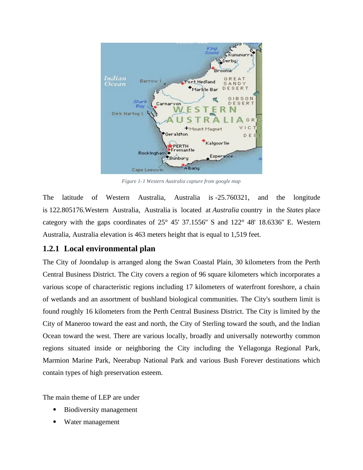
Figure 1-1 Western Australia capture from google map
The latitude of Western Australia, Australia is -25.760321, and the longitude
is 122.805176.Western Australia, Australia is located at Australia country in the States place
category with the gaps coordinates of 25° 45' 37.1556'' S and 122° 48' 18.6336'' E. Western
Australia, Australia elevation is 463 meters height that is equal to 1,519 feet.
1.2.1 Local environmental plan
The City of Joondalup is arranged along the Swan Coastal Plain, 30 kilometers from the Perth
Central Business District. The City covers a region of 96 square kilometers which incorporates a
various scope of characteristic regions including 17 kilometers of waterfront foreshore, a chain
of wetlands and an assortment of bushland biological communities. The City's southern limit is
found roughly 16 kilometers from the Perth Central Business District. The City is limited by the
City of Maneroo toward the east and north, the City of Sterling toward the south, and the Indian
Ocean toward the west. There are various locally, broadly and universally noteworthy common
regions situated inside or neighboring the City including the Yellagonga Regional Park,
Marmion Marine Park, Neerabup National Park and various Bush Forever destinations which
contain types of high preservation esteem.
The main theme of LEP are under
Biodiversity management
Water management
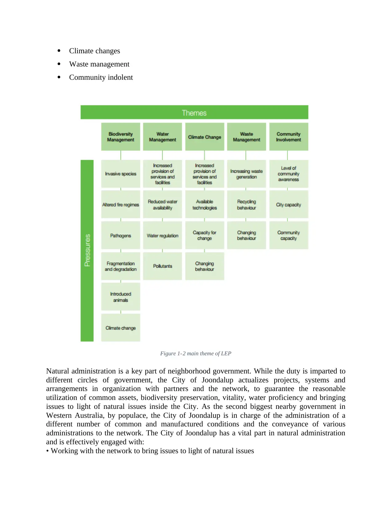
Climate changes
Waste management
Community indolent
Figure 1-2 main theme of LEP
Natural administration is a key part of neighborhood government. While the duty is imparted to
different circles of government, the City of Joondalup actualizes projects, systems and
arrangements in organization with partners and the network, to guarantee the reasonable
utilization of common assets, biodiversity preservation, vitality, water proficiency and bringing
issues to light of natural issues inside the City. As the second biggest nearby government in
Western Australia, by populace, the City of Joondalup is in charge of the administration of a
different number of common and manufactured conditions and the conveyance of various
administrations to the network. The City of Joondalup has a vital part in natural administration
and is effectively engaged with:
• Working with the network to bring issues to light of natural issues
⊘ This is a preview!⊘
Do you want full access?
Subscribe today to unlock all pages.
Trusted by 1+ million students worldwide
• Providing open doors for network training
• Developing practical waste administration choices
• Supporting effective utilization of water, vitality and different assets
• Conserving nearby biodiversity and common territories
• Developing associations to accomplish better Environmental results
• Consideration of natural results in obtaining choices
• Enhancing the common habitat of the City
Through viable land utilize arranging and advancement Control forms
• Including natural destinations in long haul Planning choices
1.2.2 Development Control Plan.
1.2.2.1 Region schemes
With the declaration on 5 May 2009 by the Minister for Planning in building up new Regional
Planning Committees and the production of the Draft Spatial Framework for Perth and Peel in
June 2009, the part of territorial and sub-local arranging will turn out to be more vital in setting
up the long haul vision for future development. The advancing territorial designs and plans will
be critical in guaranteeing that satisfactory land is made accessible for an assortment of
advancement necessities. At provincial and sub-local scales, there is the chance to deliver vital
issues identifying with game and dynamic entertainment, especially as a component of the more
extensive conveyance of a scope of desires that add to the personal satisfaction of the region
concerned. Specifically, the accompanying viewpoints should be fused inside territorial plans:
The commitment of game and dynamic amusement.
• Ensuring that the wide advantages of game and dynamic diversion and its commitment
to ecological supportability, network security, neighborhood monetary feasibility, personal
satisfaction, wellbeing and training guidelines is perceived inside the long haul spatial vision and
methodology for the areas and sub-districts. Ensuring and improving game and diversion assets.
Paraphrase This Document
Need a fresh take? Get an instant paraphrase of this document with our AI Paraphraser
• Where a verifiable need is distinguished, empowering the assignment and assurance of
future territories for sport which are of sub-local, local, national or global significance.
Advancing the security and upgrade of existing game and amusement foundation.
• Particularly vital open space and green foundation, including the insurance of existing
vital diversion courses, systems or hallways where require has been tastefully illustrated.
Empowering the assurance and upgrade of existing vital games offices. • Those current offices
that give donning chances of sub-provincial, local or national significance over all networks and
meet a demonstrated need. Defending and contributing. • Where existing offices are never
again satisfactory or never again required, to justify a protected fitting assets for elective
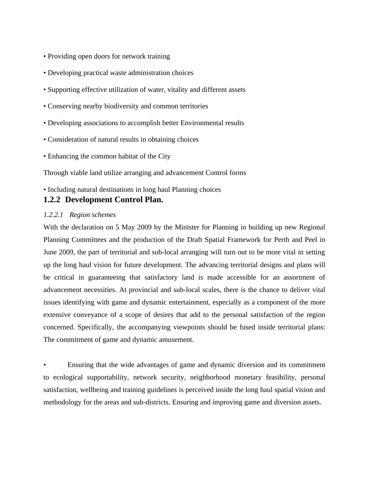
diversion offices that meet contemporary and future rising needs. The accompanying table
distinguishes the general targets of a local or sub-local arrangement or plan (left section) and the
inquiries to be raised by the relaxation proficient (right segment). On the off chance that the
inquiries raised are not reasonably tended to inside the draft local arrangement or plan, it is the
obligation of the relaxation expert to guarantee that these are tended to through formal
neighborhood government channels and portrayal through DSR.
Figure 1-3 objective of reasons
future territories for sport which are of sub-local, local, national or global significance.
Advancing the security and upgrade of existing game and amusement foundation.
• Particularly vital open space and green foundation, including the insurance of existing
vital diversion courses, systems or hallways where require has been tastefully illustrated.
Empowering the assurance and upgrade of existing vital games offices. • Those current offices
that give donning chances of sub-provincial, local or national significance over all networks and
meet a demonstrated need. Defending and contributing. • Where existing offices are never
again satisfactory or never again required, to justify a protected fitting assets for elective
diversion offices that meet contemporary and future rising needs. The accompanying table
distinguishes the general targets of a local or sub-local arrangement or plan (left section) and the
inquiries to be raised by the relaxation proficient (right segment). On the off chance that the
inquiries raised are not reasonably tended to inside the draft local arrangement or plan, it is the
obligation of the relaxation expert to guarantee that these are tended to through formal
neighborhood government channels and portrayal through DSR.
Figure 1-3 objective of reasons
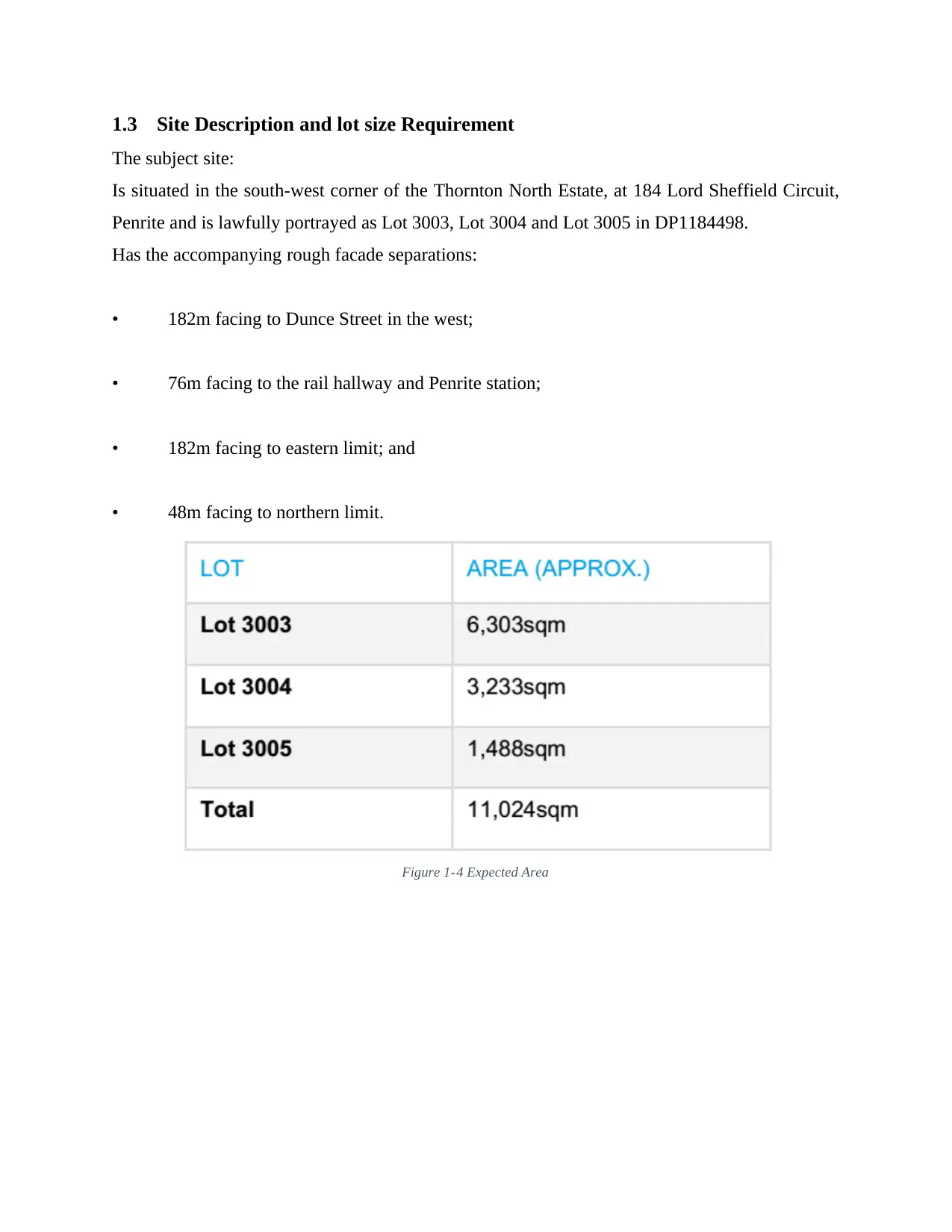
1.3 Site Description and lot size Requirement
The subject site:
Is situated in the south-west corner of the Thornton North Estate, at 184 Lord Sheffield Circuit,
Penrite and is lawfully portrayed as Lot 3003, Lot 3004 and Lot 3005 in DP1184498.
Has the accompanying rough facade separations:
• 182m facing to Dunce Street in the west;
• 76m facing to the rail hallway and Penrite station;
• 182m facing to eastern limit; and
• 48m facing to northern limit.
Figure 1-4 Expected Area
⊘ This is a preview!⊘
Do you want full access?
Subscribe today to unlock all pages.
Trusted by 1+ million students worldwide
Table 1-1 Surrounding land Usage
1.4 TRANSPORT AND ACCESSIBILITY
Table 1-2 Lot size Requirement
The site is very available by open transport, including: 20m (approx.) stroll to the Penrite Station
which is overhauled by the Blue Mountains Line (Bathurst to Central) and the North Shore Line
(Emu Plains to City and Richmond to City). 70m (approx.) stroll to Penrite transport trade which
is overhauled by the accompanying transport courses:
• Route 673 (Penrite to Windsor).
• Route 677/678 (Penrite to Richmond).
• Route 689 (Penrite to Leona Loop).
• Route 690P (Penrite to Springwood).
• Route 691 (Penrite to Blaxland).
• Route 780 (Penrite to Mt Druitt).
• Route 781/782 (Penrite to St Mary's).
• Route 785 (Penrite to Werrington).
• Route 786 (Penrite Loop by means of North Penrite).
• Route 789 (Penrite to Ludden ham).
• Route 794 (Penrite to Muglia Rise).
Paraphrase This Document
Need a fresh take? Get an instant paraphrase of this document with our AI Paraphraser
• Route 795 (Penrite to Wargame).
• Route 797 (Penrite to Glenmore Park).
2 Subdivision planning
The WAPC decides all green title, constructed, empty and review strata subdivision (with the
exception of manufactured strata subdivision utilizations of five parts and under which are
controlled by Local Government).
Application to the WAPC for subdivision endorsement is started by the landowner/designer.
Subdivision applications are held up with supporting data, including an arrangement, and are
handled by the Department of Planning, Lands and Heritage in the interest of the WAPC.
Subdivision applications are enrolled by the Department of Planning, Lands and Heritage at that
point alluded to significant State government organizations and the Local Government for input
on whether to give restrictive or unlimited endorsement, or refusal. All applications are alluded
to the pertinent Local Government, Western Power and the Water Corporation. Other
conceivable referral offices incorporate the Department of Biodiversity, Conservation and
Attractions, Department of Water and Environment Regulation, Main Roads Western Australia
(MRWA), Swan River Trust, Fire and Emergency Services, Department of Health, Department
of Agriculture and Department of Education.
2.1 COST MANAGEMENT
Overseeing costs successfully over a task that included direct commitment with numerous offices
required an imaginative way to deal with money related administration and an abnormal state of
coordination between organizations – especially the Department of Transport, Land gate and
Department of Parks and Wildlife. The general achievement of this approach utilized existing
long-standing coordinated effort between these offices through the WA Land Information
System (WALIS). The venture has additionally upgraded the level of joint effort between these
offices and others; with the possibility to drive assist efficiencies in information administration
and coordination of beach front and marine administration into what's to come[25].
A venture execution group was framed at the Department of Transport drawing on work force
with nitty gritty information and entrenched systems over the important offices through WALIS.
This group was formally connected via Land gate, giving fund and human asset administration
assets to disentangle the organization of the undertaking, dispensing with any potential
duplication of managerial overheads. The group was then sent into the Department of Transport
and along these lines the Department of Parks and Wildlife to embrace the work to work
intimately with staff at these offices in charge of the information. This has empowered an
intensive hand-over process for continuous administration of the information in which the
program has contributed[26].
The subsidizing for the MCV venture was overseen via Land gate in interview with the
Department of Regional Development. MCV venture colleagues were utilized and overseen
through the Land gate Payroll framework. Buy of gear and other operational expenses were
likewise endorsed and overseen through Land gate. Particular game plans were made under this
framework for specific things of use.
In all cases demands for buys were raised to Land gate for endorsement in counsel with the
MCV group and pertinent host organizations according to the accompanying illustrations:
Bathymetric Information System (BIS)
• Purchased by the Department of Transport through the Department of Transport
delicate framework. Last solicitations introduced to the MCV venture.
• The MCV venture group orchestrated a Department of Transport receipt routed to
Land gate with outline and receipt duplicates.
• Payment made to the Department of Transport from Land gate.
• PC equipment
• Purchased by the Department of Parks and Wildlife for the MCV venture. Last
solicitations exhibited to the MCV venture.
• MCV organized Department of Parks and Wildlife receipt routed to Land gate
with rundown and receipt duplicates.
• Payment made to Department of Parks and Wildlife from Land gate. Duplicates
all things considered and administration records are connected
2.2 COMMUNICATIONS MANAGEMENT
Viable interchanges for the MCV venture were basic in effectively dealing with a group that
moved between associations all through the undertaking, and in working with an assorted scope
of open and private area partners crosswise over State and Local Government, and beach front
and marine specialists and scientists.
The MCV venture could use a current system and connections between these gatherings through
WALIS, and added to Key Performance Indicators (KPI) followed by WALIS and utilized for
covering the execution of the more extensive LIS program. The MCV venture increased these
current plans with particular interchanges for the partners all the more straightforwardly engaged
with beach front and marine administration – particularly through a bulletin, and introductions at
significant gatherings and different occasions facilitated by these partners[31]–[33].
⊘ This is a preview!⊘
Do you want full access?
Subscribe today to unlock all pages.
Trusted by 1+ million students worldwide
1 out of 22
Your All-in-One AI-Powered Toolkit for Academic Success.
+13062052269
info@desklib.com
Available 24*7 on WhatsApp / Email
![[object Object]](/_next/static/media/star-bottom.7253800d.svg)
Unlock your academic potential
Copyright © 2020–2026 A2Z Services. All Rights Reserved. Developed and managed by ZUCOL.