Civil Estimating Assignment #2: Cut and Fill Calculations and Analysis

Verified

Added on  2022/10/04

|8
|1136
|17
Homework Assignment
AI Summary
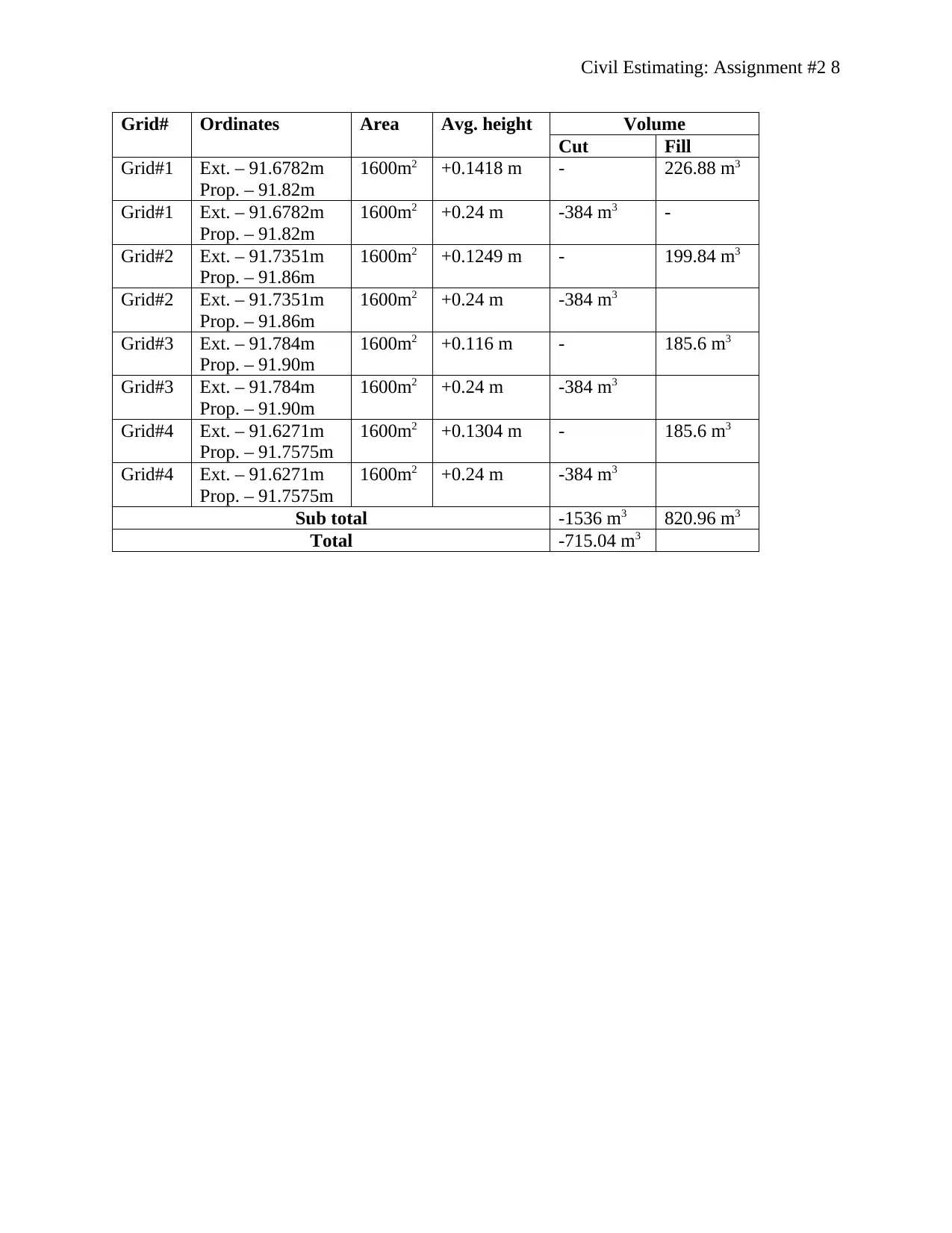
This assignment solution demonstrates the application of the 4-corner method for calculating cut and fill volumes in a parking lot project. The solution begins by outlining the steps involved in the 4-corner method, including grid cell creation, elevation determination, and volume calculation. Existing and proposed elevations are determined for each grid corner, and average cut/fill depths are computed. The area of each grid cell is calculated, and the cut or fill volume is determined by multiplying the area by the average depth. The total fill and cut volumes are then calculated, and the need for import or export of materials is assessed. The solution considers the removal of topsoil and presents an earthwork estimating worksheet summarizing the calculations. The final result indicates that a total material cut is required to achieve the proposed elevation for the parking lot project. The assignment provides a detailed breakdown of the calculations, including the area and volume for each grid, and concludes with a summary of the findings. This assignment is a valuable resource for students studying civil engineering and related fields. The document is contributed to Desklib, a platform offering AI-powered study tools for students.
Document Page
Civil Estimating: Assignment #2 1
CIVIL ESTIMATING: ASSIGNMENT #2
Name
Course
Professor
University
City/state
Date
tabler-icon-diamond-filled.svg

Paraphrase This Document

Need a fresh take? Get an instant paraphrase of this document with our AI Paraphraser
Document Page
Civil Estimating: Assignment #2 2
Civil Estimating: Assignment #2
4-corner method
The parking lot examined in this scenario has four grids. 4-corner method involves four main
steps when estimating cut and fill volumes of earthworks. The first step is to draw uniform grid
cells on the earthworks project’s plan. The second step is to determine the existing ground
elevations (levels) for each corner or node of the grid cells. The third step is to determine the
proposed ground elevations (levels) for each corner of the grid cells. The fourth step is to
determine the difference between proposed ground elevation and the existing ground elevation
(proposed ground elevation – existing ground elevation) for each of the grid cell corners/nodes.
Positive values from this difference indicate that the materials at that grind are fill whereas
negative values indicate that the materials at that grid are cut. The fifth step is to determine the
average fill or cut depth for each grid cell. This is done by taking the sum of the fill or cut depth
for each corner of the grid cell and dividing it by four.
The sixth step is to calculate the area of each grid cell by multiplying the length of the cell by its
width. The seventh step is to calculate the cut or fill volume for each grid cell by multiplying the
area of the grid cell with its average cut or fill depth. The eight step is to calculate total volume
of fill and/or cut by adding all the positive values to determine total fill volume and all negative
values to determine total cut volume. The last step is to determine the difference between total
fill volume and total cut volume so as to find out if there are surplus materials to be exported
from the site or there are less materials to necessitate importation of new materials.
Existing elevations
Document Page
Civil Estimating: Assignment #2 3
Existing elevations are the determined by finding the average of at least two topographical
elevations provided by J.L. Richards & Associated Limited dated Oct. 2009 that are closest to
each of the grid cell corners on the parking lot drawing.
Grid #1
Node ¿ 1= 91.565+91.597+ 91.590
3 =91.584
Node ¿ 2= 91.633+91.660
2 =91.6465
Node ¿ 3= 91.687+ 91.771+ 91.702
3 =91.72
Node ¿ 4= 91.721+91.800+91.778+ 91.750
4 =91.76225
Grid #2
Node ¿ 1= 91.633+91.660
2 =91.6465
Node ¿ 2= 91.662+91.706
2 =91.684
Node ¿ 3= 91.721+91.800+91.778+ 91.750
4 =91.76225
Node ¿ 4= 91.790+91.905+91.792+ 91.903
4 =91.8475
Grid #3
Node ¿ 1= 91.662+ 91.706
2 =91.684
Document Page
Civil Estimating: Assignment #2 4
Node ¿ 2= 91.741+91.828
2 =91.7845
Node ¿ 3= 91.790+91.905+ 91.792+91.903
4 =91.8475
Node ¿ 4= 91.787+91.833
2 =91.81
Grid #4
Node ¿ 1= 91.558+91.673
2 =91.6155
Node ¿ 2= 91.621+91.704
2 =91.6625
Node ¿ 3= 91.565+91.597+ 91.590
3 =91.584
Node ¿ 4= 91.633+91.660
2 =91.6465
Proposed elevations
Proposed elevations are the new surface elevations provided at each of the grid cell corners on
the parking lot drawing.
Grid #1
Node #1 – 91.77, node #2 – 91.81, node #3 – 91.83, and node #4 – 91.87
Grid #2
Node #1 – 91.81, node #2 – 91.85, node #3 – 91.87, and node #4 – 91.91
Grid #3
tabler-icon-diamond-filled.svg

Paraphrase This Document

Need a fresh take? Get an instant paraphrase of this document with our AI Paraphraser
Document Page
Civil Estimating: Assignment #2 5
Node #1 – 91.85, node #2 – 91.89, node #3 – 91.91, and node #4 – 91.95
Grid #4
Node #1 – 91.70, node #2 – 91.75, node #3 – 91.77, and node #4 – 91.81
Average fill/cut depth
Grid#1
Average existing elevation = 91.584+91.6465+ 91.72+91.76225
4 =91.6782
Average proposed elevation = 91.77+91.81+91.83+91.87
4 =91.82
Average depth = proposed elevation – existing elevation = 91.82 – 91.6782 = +0.1418 m (fill)
Grid#2
Average existing elevation = 91.6465+91.684+91.76225+91.8475
4 =91.7351
Average proposed elevation = 91.81+91.85+91.87+91.91
4 =91.86
Average depth = proposed elevation – existing elevation = 91.86 – 91.7351 = +0.1249 m (fill)
Grid#3
Average existing elevation = 91.684+91.7845+91.8575+91.81
4 =91.784
Average proposed elevation = 91.85+91.89+91.91+91.95
4 =91.90
Average depth = proposed elevation – existing elevation = 91.90 – 91.784 = +0.116 m (fill)
Document Page
Civil Estimating: Assignment #2 6
Grid#4
Average existing elevation = 91.6155+91.6625+91.584 +91.6465
4 =91.6271
Average proposed elevation = 91.70+91.75+ 91.77+91.81
4 =91.7575
Average depth = proposed elevation – existing elevation = 91.7575 – 91.6271 = +0.1304 m (fill)
Area of grid cells
Each of the four grid cells is a square measuring 40 m by 40 m. Therefore area of each grid cell
is calculated as follows:
Area = 40 m x 40 m = 1,600 m2
Volume of grid cells
Grid#1
Volume = 1,600 m2 x 0.1418 m = 226.88 m3
Grid#2
Volume = 1,600 m2 x 0.1249 m = 199.84 m3
Grid#3
Volume = 1,600 m2 x 0.116m = 185.6 m3
Grid#4
Volume = 1,600 m2 x 0.1304 m = 208.64 m3
Total volume
Document Page
Civil Estimating: Assignment #2 7
Total volume = grid#1 volume + grid#2 volume + grid#3 volume + grid#4 volume
= 226.88 m3 + 199.84 m3 + 185.6 m3 + 208.64 m3
= 820.96 m3
Import or export materials
Since the total volume is fill volume only, it means that soil material of volume 820.96 m3 will
have to be imported to the site.
Additionally, it has been assumed that an average of 240mm of topsoil has to be removed before
the start of any construction. This may be due to the condition of the soil that necessitates this
excavation of topsoil so as to get a more stable ground for the foundation. It means that the total
volume to be removed (cut) based on this required is: (4 x 1600 m2) x 0.24 m = -1,536 m3
Summary
Since cut volume is greater than fill volume, it means that the total excavation material will be
cut. Therefore the total material that has to be cut so as to achieve the proposed elevation for the
parking lot project is:
820.96 m2 – 1,536 m3 = -715.04 m3
Earthwork estimating sheet
The earthwork estimating worksheet is provided in Table 1 below.
Ext. – Existing elevation
Prop. – Proposed elevation
Table 1: Earthwork estimating worksheet
tabler-icon-diamond-filled.svg

Paraphrase This Document

Need a fresh take? Get an instant paraphrase of this document with our AI Paraphraser
Document Page
Civil Estimating: Assignment #2 8
Grid# Ordinates Area Avg. height Volume
Cut Fill
Grid#1 Ext. – 91.6782m
Prop. – 91.82m
1600m2 +0.1418 m - 226.88 m3
Grid#1 Ext. – 91.6782m
Prop. – 91.82m
1600m2 +0.24 m -384 m3 -
Grid#2 Ext. – 91.7351m
Prop. – 91.86m
1600m2 +0.1249 m - 199.84 m3
Grid#2 Ext. – 91.7351m
Prop. – 91.86m
1600m2 +0.24 m -384 m3
Grid#3 Ext. – 91.784m
Prop. – 91.90m
1600m2 +0.116 m - 185.6 m3
Grid#3 Ext. – 91.784m
Prop. – 91.90m
1600m2 +0.24 m -384 m3
Grid#4 Ext. – 91.6271m
Prop. – 91.7575m
1600m2 +0.1304 m - 185.6 m3
Grid#4 Ext. – 91.6271m
Prop. – 91.7575m
1600m2 +0.24 m -384 m3
Sub total -1536 m3 820.96 m3
Total -715.04 m3
chevron_up_icon
1 out of 8
circle_padding
hide_on_mobile
zoom_out_icon
[object Object]