Rural Land Development Plan: A Case Study of Colac Otway Shire
VerifiedAdded on 2020/05/16
|14
|3168
|362
Report
AI Summary
This report provides a comprehensive review of the rural land development plan in the Colac Otway Shire, focusing on key aspects such as agricultural industries, forestry plantations, environmental assets and threats, and relevant planning policies. The agricultural industry, contributing significantly to the region's revenue, faces challenges like farm amalgamation and the demand for lifestyle properties. Forestry, particularly timber production, impacts the local economy and ecosystem. Environmental threats, including salinity, landslides, and flooding, necessitate careful planning and mitigation strategies. The report also examines the State Planning Policy Framework (SPPF) and Municipal Strategic Statement (MSS), emphasizing the importance of sustainable development and afforestation. Trends in farm businesses over time reveal shifts in commodity production and farm numbers, impacting rural populations and land use. Ultimately, the report underscores the need for effective planning schemes to address these multifaceted issues and ensure the sustainable development of the Colac Otway Shire. Desklib offers a range of study tools and resources, including solved assignments and past papers, to support students in understanding complex topics like rural development planning.
Running head: PLANNING PROCESS AND PRACTICE
Planning process and practice
Name of the Student
Name of the University
Author’s Note
Planning process and practice
Name of the Student
Name of the University
Author’s Note
Paraphrase This Document
Need a fresh take? Get an instant paraphrase of this document with our AI Paraphraser
1
PLANNING PROCESS AND PRACTICE
Table of Contents
Introduction......................................................................................................................................4
Agricultural Industries in the Colac Otway Shire............................................................................4
Minimum Lot Sizes.....................................................................................................................5
Forestry plantations.....................................................................................................................6
Environment Assets and Threats.................................................................................................6
Planning Policy................................................................................................................................7
Otway Plains and Ranges............................................................................................................7
Economic value of industries in the Colac Otway Shire.................................................................8
Trends in the farm Business over time........................................................................................9
Planning Scheme Implication....................................................................................................10
State Planning Policy Framework.................................................................................................11
Municipal Strategic Statement (MSS)...........................................................................................12
Conclusion.....................................................................................................................................12
Reference.......................................................................................................................................14
2
PLANNING PROCESS AND PRACTICE
Introduction
The Colac Otway Shire include Great Ocean Road and coast that has been declared Great
Otway national park. The Shire has recognized importance of preserving high agricultural
quality land, developing sustainable forestry and various agricultural diversity (Myconos and
McKenna 2017). The industrial growth u the land is important for the development of
individuals living nearby the coast. Therefore, a planning scheme has been repapered for
maintaining the development of the Shire, The review of rural land within municipality has been
described in report.
This report deals with the rural development plan in the Shire. The Rural Conservation
Zone in the city has been properly discussed in the report. This report focuses on the Overlays,
Local and State planning policies. The methodologies for developing the plan has been explained
in the report.
This report outlines basic uses of the rural development plan under the municipality. The
use of Municipal Strategic Statements has been explained in the report. This report discusses
about outcomes of review of land and planning scheme of new rural zones.
Agricultural Industries in the Colac Otway Shire
Flentje et al. (2016) commented that agriculture industry is one of the most significant
industry in Colac Otway Shire region. The contribution of agricultural industry has helped a lot
in the development of the region. The total revenue generated from the agricultural sector has
been estimated $250 million. However, industry has contributed $82 million from the gross
value. The gross value of the development of the region. The use of the rural development plan
⊘ This is a preview!⊘
Do you want full access?
Subscribe today to unlock all pages.
Trusted by 1+ million students worldwide
3
PLANNING PROCESS AND PRACTICE
has helped in maintaining the development of the Shire. However, as detailed analysis can be
done on the agricultural industry of the state.
However, farm amalgamation has hexed in maintaining number of farms in municipality
for the development of the economic condition of the Shire, the use of proper management of the
agricultural dimensions of the agricultural method have helped in providing a proper approach
toward the development the Shire. As mentioned by Johnson and Karunanethy (2015), over 60 %
farms in the Shire have nonuse in the business perspective. Therefore, this land can be used for
the development of the rural areas in the municipality. The rural development of the Colac
Otway economy and off-farm business. This has led to an increase in the demand for healthy and
prosperous lifestyle properties. However, an emphasis on dwellings for lifestyle in farm purposes
have to compromise in long-term viability of farming in the Colac Otway Shire.
Minimum Lot Sizes
As mentioned by Hepworth (2017), the current minimum lot sizes have been reviewed in
order to calculate appropriate reflected in current circumstances. However, this review
commented that present minimum lot sizes have provision for applying in Schedule to farming
Zone needs to be retained. Therefore, a review of around 8 hectares land in context of the
agricultural capability and dwelling development of the proximity in townships. Leonard et al.
(2016) commented that the rural land plan has been beneficial for the development of the Shire.
Different aspects of the Rural Living Zone in appropriate locations in the Shore has developed
under the considerations of the government.
Forestry plantations
Paraphrase This Document
Need a fresh take? Get an instant paraphrase of this document with our AI Paraphraser
4
PLANNING PROCESS AND PRACTICE
The forestry industry in Colac Otway Shure has depicted that the timber production can
be contributor towards finance of Colac Otway Shire. Therefore, proclamation of Great Otway
national park has been maintained under the consideration of production of timber wood and
local processor employment. Cotter (2017) mentioned that the growth in the timber wood
plantation in the forest has developed the ecosystem of the Shire. The decline in the indicators of
land use has resulted in declination in the development. Expansion of the plantation of timber
wood have increased the value of the land use in the Shire, therefore, the tourism sector has
increased in the region. The use of the farming tools in the agricultural sector has helped in
maintaining the development of the rural plan. However, timber plantation has various lease
agreements with the stakeholders that depend upon the value of the land use. As the value of the
land, use has been increased due to the production of timber wood.
Environment Assets and Threats
Various threats and risks have been identified in the development of the rural plan in the
Shire. The use of the native vegetation of the private and has seen several scattered and remnants
that are vulnerable to declination. As argued by Myconos and McKenna (2017), salinity is a
threat that has been prevailing in Northern half of Shire creating water problems in the
infrastructure. The draft Corangamite Salinity Action Plan (2003-2008) identifies that risk and
threats are related to the biodiversity of the plains. The key management actions addressing
salinity that is relevant to Colac Otway Shire focuses on effects of salinity on infrastructure and
urban environment and includes:
Development of strategies with the help of local government for guiding
placement and urban subdivision;
5
PLANNING PROCESS AND PRACTICE
However, landslides are hazardous risks that have helped in maintaining the southern
end of Shire associated with the steep slopes in the Shire due to heavy rainfall. As argued by
Hepworth (2017), flooding is a threat that is prevailing in the northern part of the Otway ranges
due to the poor land clearance and drainage system. Therefore, there is the requirement for
planning scheme that helps in ensuring future of the Shire for land use in the agricultural
industry. The awareness among the individuals might help in maintaining the development of the
region by planting trees and plants. The risks and threats prevailing in the Shire have developed
an opportunity for the making decisions in order to mitigate those risks and threats. The use of
the proper planning and designing might help in mitigating the threats and risks involved in the
development of the region. Environmental factors have deviated the development on the rural
development plan including the earthquake, volcano and heavy rainfall. These calamities have
restricted the development of rural development plan.
Planning Policy
As commented by Cotter (2017), the key objective of the study has focused on the
strengths for promoting the development of the environmental factors. The key sustainable
development of the ecosystem in the Shire is depended on the afforestation in the region. The
awareness among the individuals might help in maintaining the development of the region by
planting trees and plants. As suggested by Neale (2015), the tourism industry has helped in
encouraging diversification of economy and ensures environmental features to be accessed in the
arena.
Otway Plains and Ranges
⊘ This is a preview!⊘
Do you want full access?
Subscribe today to unlock all pages.
Trusted by 1+ million students worldwide
6
PLANNING PROCESS AND PRACTICE
Various environmental factors have been prevailing that are providing sustainability to
the National and Regional development plans. As mentioned by Rydon (2017), the cultural
diversity in the plains has helped in maintaining among the divarication in the land. Several
groups of people are living in various places of the Shire creating a huge cultural diversification.
The farming zone of majority of people in the rural areas have dwellings based in the minimum
area for a farming system.
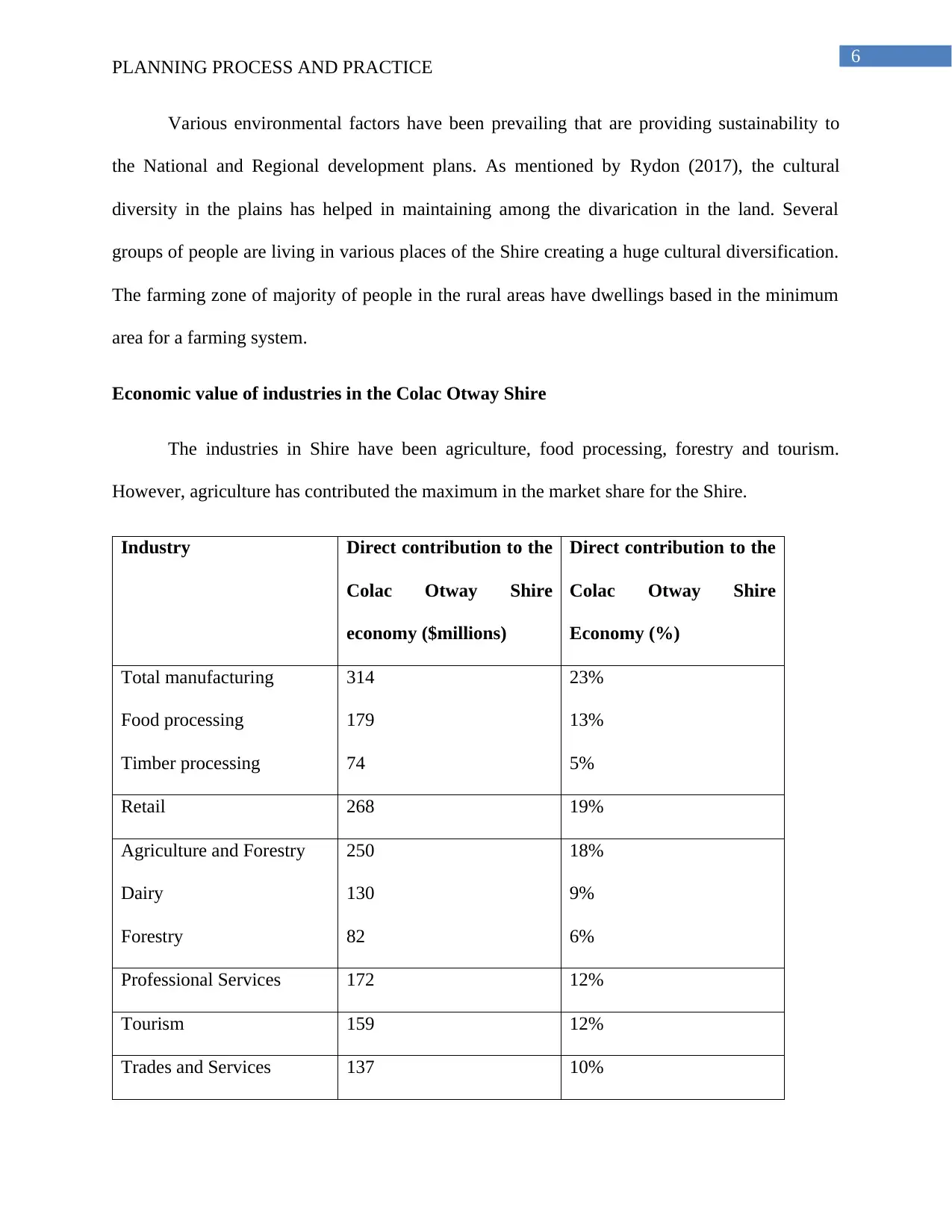
Economic value of industries in the Colac Otway Shire
The industries in Shire have been agriculture, food processing, forestry and tourism.
However, agriculture has contributed the maximum in the market share for the Shire.
Industry Direct contribution to the
Colac Otway Shire
economy ($millions)
Direct contribution to the
Colac Otway Shire
Economy (%)
Total manufacturing
Food processing
Timber processing
314
179
74
23%
13%
5%
Retail 268 19%
Agriculture and Forestry
Dairy
Forestry
250
130
82
18%
9%
6%
Professional Services 172 12%
Tourism 159 12%
Trades and Services 137 10%
PLANNING PROCESS AND PRACTICE
Various environmental factors have been prevailing that are providing sustainability to
the National and Regional development plans. As mentioned by Rydon (2017), the cultural
diversity in the plains has helped in maintaining among the divarication in the land. Several
groups of people are living in various places of the Shire creating a huge cultural diversification.
The farming zone of majority of people in the rural areas have dwellings based in the minimum
area for a farming system.
Economic value of industries in the Colac Otway Shire
The industries in Shire have been agriculture, food processing, forestry and tourism.
However, agriculture has contributed the maximum in the market share for the Shire.
Industry Direct contribution to the
Colac Otway Shire
economy ($millions)
Direct contribution to the
Colac Otway Shire
Economy (%)
Total manufacturing
Food processing
Timber processing
314
179
74
23%
13%
5%
Retail 268 19%
Agriculture and Forestry
Dairy
Forestry
250
130
82
18%
9%
6%
Professional Services 172 12%
Tourism 159 12%
Trades and Services 137 10%
Paraphrase This Document
Need a fresh take? Get an instant paraphrase of this document with our AI Paraphraser
7
PLANNING PROCESS AND PRACTICE
Health and community
service
87 6%
Total 1387 100%
Table 1: Estimated contribution made by major industries to the Colac Otway Shire
economy in 2001/2002
(Source: Clarke, Heady and Erwin 2017, pp.39)
Trends in the farm Business over time
Clarke, Heady and Erwin (2017) commented that there has a drastic change in the trend
in the farm business time that indicates changes in the hectares of crop number of farms and
number of an agricultural commodity. Andersson et al. (2017) suggested that number of dairy
cows have increased but number of dairy farms have decreased by 44%. Wool and vegetable
production have been decreased in various aspects of the market.
Commodity Production and
number of
farms
1983 2001 Change
Dairy cows
farms
94,264
681
99,062
381
5%
-44%
Beef cows
farms
47,758
706
56,918
436
19%
-38%
Vegetables Hectares Tonnes
farms
573
12,732
68
259
6656
15
-55%
-52%
-79%
Sheep Tonnes of wool
sheepshorn
farms
1,235
365,171
273
852
218,699
136
-31%
-40%
-50%
Nurseries/Cut
flowers
Hectares
farms
0
0
13
9
Grain Hectares
Tones
3504
2523
4149
14992
18%
500%
8
PLANNING PROCESS AND PRACTICE
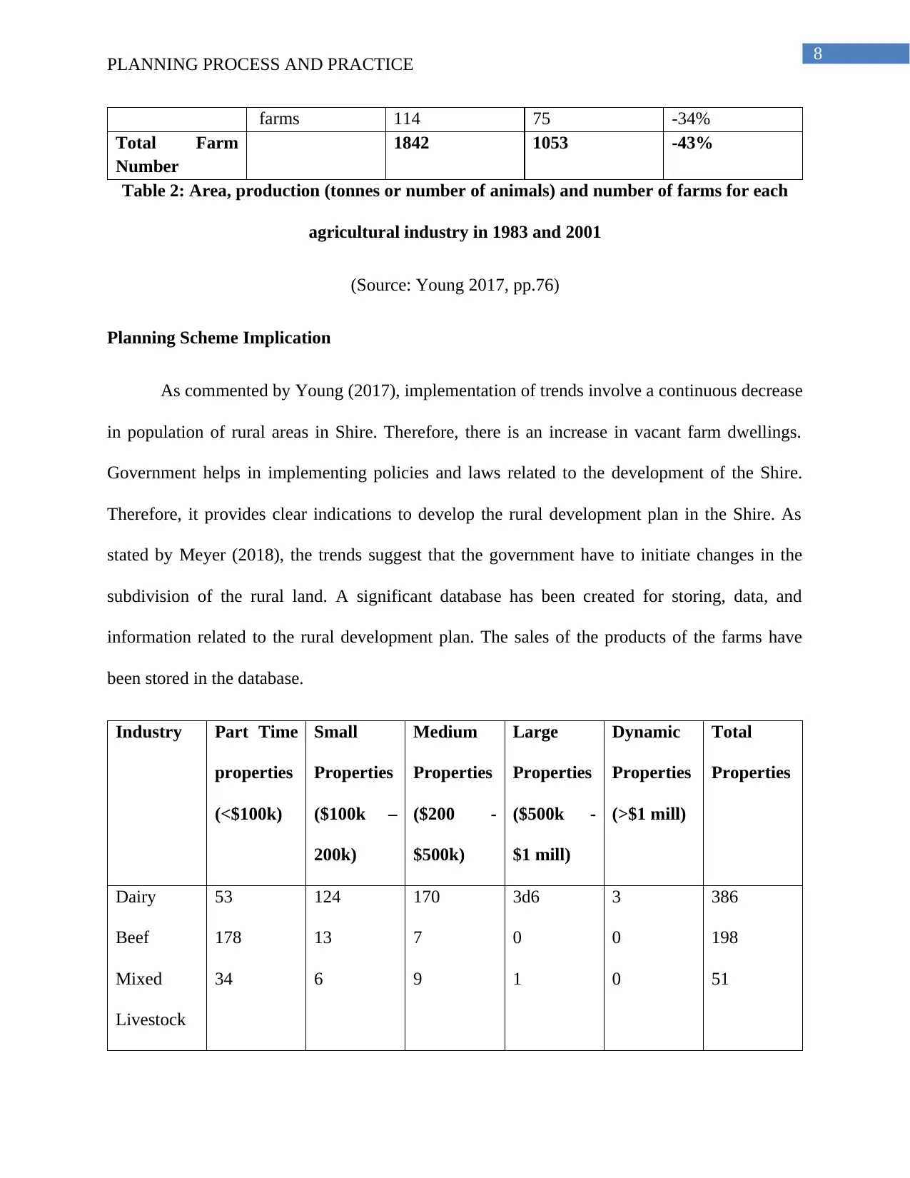
farms 114 75 -34%
Total Farm
Number
1842 1053 -43%
Table 2: Area, production (tonnes or number of animals) and number of farms for each
agricultural industry in 1983 and 2001
(Source: Young 2017, pp.76)
Planning Scheme Implication
As commented by Young (2017), implementation of trends involve a continuous decrease
in population of rural areas in Shire. Therefore, there is an increase in vacant farm dwellings.
Government helps in implementing policies and laws related to the development of the Shire.
Therefore, it provides clear indications to develop the rural development plan in the Shire. As
stated by Meyer (2018), the trends suggest that the government have to initiate changes in the
subdivision of the rural land. A significant database has been created for storing, data, and
information related to the rural development plan. The sales of the products of the farms have
been stored in the database.
Industry Part Time
properties
(<$100k)
Small
Properties
($100k –
200k)
Medium
Properties
($200 -
$500k)
Large
Properties
($500k -
$1 mill)
Dynamic
Properties
(>$1 mill)
Total
Properties
Dairy
Beef
Mixed
Livestock
53
178
34
124
13
6
170
7
9
3d6
0
1
3
0
0
386
198
51
PLANNING PROCESS AND PRACTICE
farms 114 75 -34%
Total Farm
Number
1842 1053 -43%
Table 2: Area, production (tonnes or number of animals) and number of farms for each
agricultural industry in 1983 and 2001
(Source: Young 2017, pp.76)
Planning Scheme Implication
As commented by Young (2017), implementation of trends involve a continuous decrease
in population of rural areas in Shire. Therefore, there is an increase in vacant farm dwellings.
Government helps in implementing policies and laws related to the development of the Shire.
Therefore, it provides clear indications to develop the rural development plan in the Shire. As
stated by Meyer (2018), the trends suggest that the government have to initiate changes in the
subdivision of the rural land. A significant database has been created for storing, data, and
information related to the rural development plan. The sales of the products of the farms have
been stored in the database.
Industry Part Time
properties
(<$100k)
Small
Properties
($100k –
200k)
Medium
Properties
($200 -
$500k)
Large
Properties
($500k -
$1 mill)
Dynamic
Properties
(>$1 mill)
Total
Properties
Dairy
Beef
Mixed
Livestock
53
178
34
124
13
6
170
7
9
3d6
0
1
3
0
0
386
198
51
⊘ This is a preview!⊘
Do you want full access?
Subscribe today to unlock all pages.
Trusted by 1+ million students worldwide
9
PLANNING PROCESS AND PRACTICE
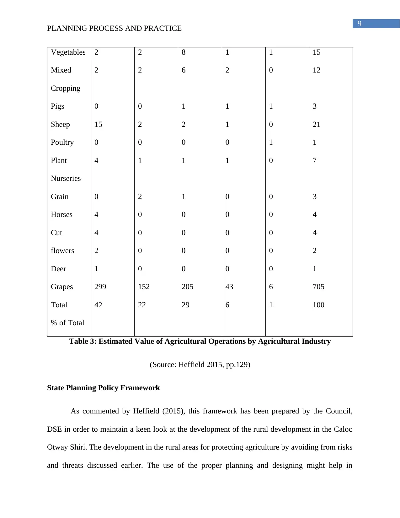
Vegetables
Mixed
Cropping
Pigs
Sheep
Poultry
Plant
Nurseries
Grain
Horses
Cut
flowers
Deer
Grapes
Total
% of Total
2
2
0
15
0
4
0
4
4
2
1
299
42
2
2
0
2
0
1
2
0
0
0
0
152
22
8
6
1
2
0
1
1
0
0
0
0
205
29
1
2
1
1
0
1
0
0
0
0
0
43
6
1
0
1
0
1
0
0
0
0
0
0
6
1
15
12
3
21
1
7
3
4
4
2
1
705
100
Table 3: Estimated Value of Agricultural Operations by Agricultural Industry
(Source: Heffield 2015, pp.129)
State Planning Policy Framework
As commented by Heffield (2015), this framework has been prepared by the Council,
DSE in order to maintain a keen look at the development of the rural development in the Caloc
Otway Shiri. The development in the rural areas for protecting agriculture by avoiding from risks
and threats discussed earlier. The use of the proper planning and designing might help in
PLANNING PROCESS AND PRACTICE
Vegetables
Mixed
Cropping
Pigs
Sheep
Poultry
Plant
Nurseries
Grain
Horses
Cut
flowers
Deer
Grapes
Total
% of Total
2
2
0
15
0
4
0
4
4
2
1
299
42
2
2
0
2
0
1
2
0
0
0
0
152
22
8
6
1
2
0
1
1
0
0
0
0
205
29
1
2
1
1
0
1
0
0
0
0
0
43
6
1
0
1
0
1
0
0
0
0
0
0
6
1
15
12
3
21
1
7
3
4
4
2
1
705
100
Table 3: Estimated Value of Agricultural Operations by Agricultural Industry
(Source: Heffield 2015, pp.129)
State Planning Policy Framework
As commented by Heffield (2015), this framework has been prepared by the Council,
DSE in order to maintain a keen look at the development of the rural development in the Caloc
Otway Shiri. The development in the rural areas for protecting agriculture by avoiding from risks
and threats discussed earlier. The use of the proper planning and designing might help in
Paraphrase This Document
Need a fresh take? Get an instant paraphrase of this document with our AI Paraphraser
10
PLANNING PROCESS AND PRACTICE
mitigating the threats and risks involved in the development of the region. The key sustainable
development of the ecosystem in the Shire is depended on the afforestation in the region.
Minimizing the servicing costs by the local State government might help in the growth of the
rural development plan. As mentioned by Authority (2015), the SPFF has focused on the
development of the housing colony for individuals in the state.
Municipal Strategic Statement (MSS)
The recent MSS includes strategic directions that have been relevant to the clause 21.04-2
(Nature of land) and clause 21.04-5 (Primary Industry). The Shire accepts the importance of the
agriculture and forestry for providing the maximum revenue generation to the state. As
mentioned by HALL (2014), the use of timber wood has helped in encouraging agricultural
diversity and ensure sustainable development of the rural areas. The use of the proper planning
and designing might help in mitigating the threats and risks involved in the development of the
region. Environmental factors have deviated the development on the rural development plan
including the earthquake, volcano and heavy rainfall. The Shire has focused on the development
of the agriculture sector in the stare that helps in growth of rural people and municipality of the
site. However, growth of rural areas is directly dependent on the growth of the agricultural sector
and minimized threats and risks. As mentioned by Meyer (2014), there are various directions for
the study on updated material in the rural areas including agricultural industries, agricultural
capabilities, forestry plantations, environmental considerations and rural living opportunities.
Conclusion
It can be concluded that the rural development plan of the Caloc Otway Shiri has helped
in developing the rural area in that region. The agriculture industry has been the most prominent
11
PLANNING PROCESS AND PRACTICE
industry in that region. This industry has contributed the most to the revenue of this state. Other
industries include forestry, food and tourism. The risks and threats prevailing in the Shire have
developed an opportunity for the making decisions in order to mitigate those risks and threats.
These industries have helped in the development of the rural areas in the Shire. However, some
threats and risks in the Shire that have restricted development plan. The key sustainable
development of the ecosystem in the Shire is depended on the afforestation in the region. The
awareness among the individuals might help in maintaining the development of the region by
planting trees and plants. There have been various changes in the trends of the development plan
for creating opportunities in the growth of the rural areas. These threats and risks include
landslides, flooding cultural diversity. Rural areas have been suffering from the natural
calamities including heavy rain and volcanos. Therefore, the rural development has been
restricted to these threats and risks. Therefore, the government have created various strategies for
the development of the rural areas.
⊘ This is a preview!⊘
Do you want full access?
Subscribe today to unlock all pages.
Trusted by 1+ million students worldwide
1 out of 14
Related Documents


Your All-in-One AI-Powered Toolkit for Academic Success.
+13062052269
info@desklib.com
Available 24*7 on WhatsApp / Email
![[object Object]](/_next/static/media/star-bottom.7253800d.svg)
Unlock your academic potential
Copyright © 2020–2026 A2Z Services. All Rights Reserved. Developed and managed by ZUCOL.