NURBN1004 Community Profile
VerifiedAdded on 2019/11/12
|24
|6473
|354
Practical Assignment
AI Summary
This assignment involves a comprehensive fieldwork-based analysis of the Dandenong community in Australia. Students are tasked with creating a community profile report and a fieldwork workbook, documenting observations and statistical evidence related to various aspects of the community's health and socioeconomic status. The workbook is structured around twelve elements, grouped into four topics: People and Culture, Environment and Accessibility, Socioeconomic State and Connection, and Services and Resources. Each element requires students to collect data, make comparisons with other LGAs or Victoria as a whole, and analyze the impact on the community's health. The final deliverable includes a fact sheet summarizing key findings and an analysis of three significant health issues within the community, explaining their underlying causes. The assignment emphasizes the use of current, relevant data and proper referencing in APA format.
2017 NURBN1004 Fieldwork Workbook
Instructions:CHOOSE DANDENONG COMMUNITY
ALL elements (12) are to be completed throughout the 8 week fieldwork period and this workbook is
then to be submitted for assessmentby 5pm, Friday 22nd Septemberalong with your Community
Profile Fact Sheet.
The elements are grouped strategically so you are addressing 3 elements each field work session;
which is every fortnight. They are grouped into topics, which are:
People and Culture
Environment and Accessibility
Socioeconomic State and Connection
Services and Resources
You will notice that each template has a coloured section at the bottom of the page and each
fieldwork session has a group of elements that is in one particular colour. Eg: Week 2 elements are
green, Week 4 elements are orange, and so on. ALL element groups are to be completed within the
8 week period allocated.
During your fieldwork, you are to collect relevant observations and statistical evidence and
document them in the appropriate column inDOT FORM within the space provided. Be succinct.ONE
page per element ONLY is to be created.You may use smaller text, but no less than size 10 font is to
be used. Photos can be included and shrunk down in size. Photos are to be referenced by stating
YOU as the photographer, location and the date it was taken. Data must be current, relevant and
referenced correctly. NO PHOTOS are to be taken directly of people.
Once you have gathered your evidence, you then need to step back and interpret what all the
information means- What does this all mean in terms of health for this population? Make a short
summary and demonstrate your understanding of the overall impact of each element on this
population, by answering the question in the coloured box at the bottom of each page. Use the
marking guide to ensure you are meeting all assessment requirements.
NOTE: The observations and evidence you can use during your fieldwork can include information
from all your senses. What do you see? What do you hear? What can you smell? Also use other
resources such as local television, newspapers or radio; what does this tell you about this
community? Look on local notice boards, newsletters, etc.
Fieldwork Workbook: weeks 1-2
People and Culture
Paraphrase This Document
Need a fresh take? Get an instant paraphrase of this document with our AI Paraphraser
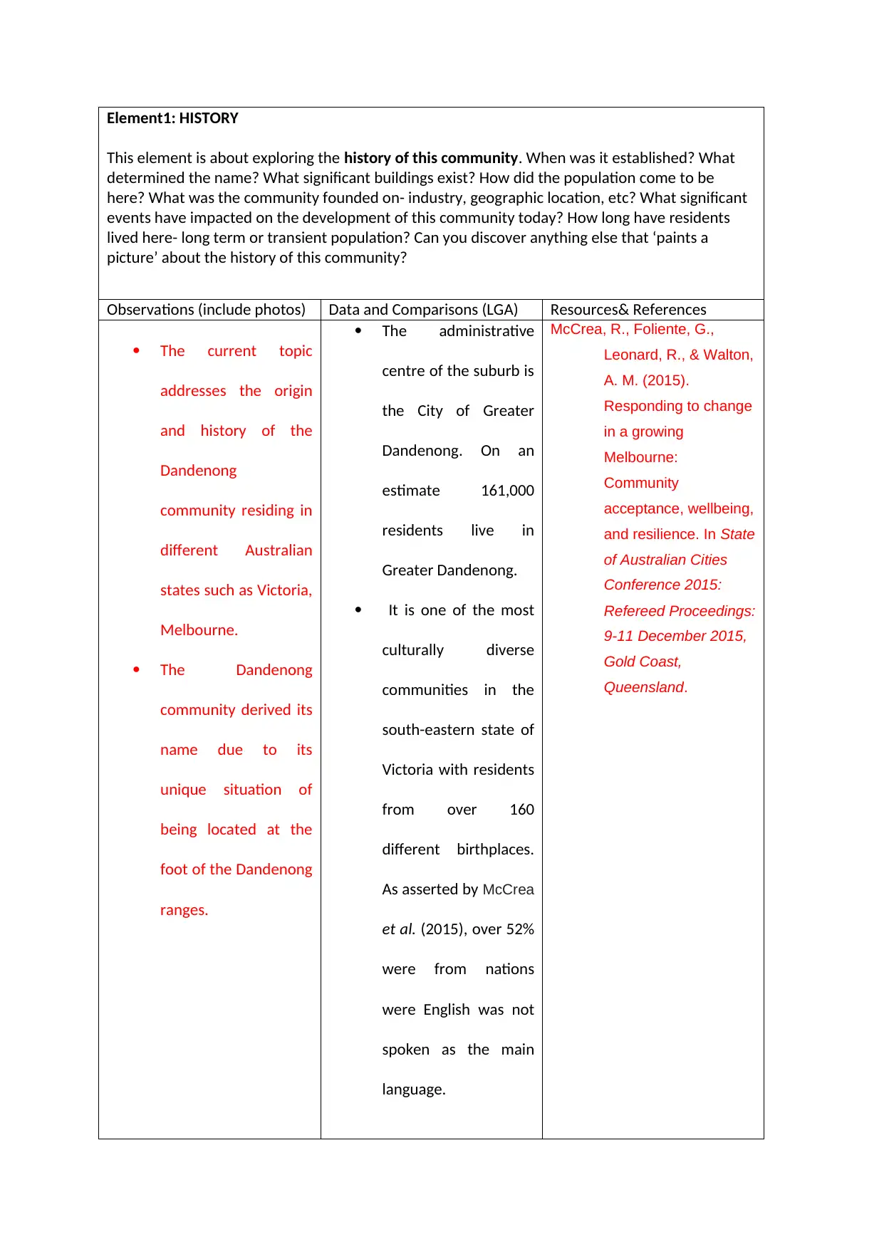
Element1: HISTORY
This element is about exploring the history of this community. When was it established? What
determined the name? What significant buildings exist? How did the population come to be
here? What was the community founded on- industry, geographic location, etc? What significant
events have impacted on the development of this community today? How long have residents
lived here- long term or transient population? Can you discover anything else that ‘paints a
picture’ about the history of this community?
Observations (include photos) Data and Comparisons (LGA) Resources& References
The current topic
addresses the origin
and history of the
Dandenong
community residing in
different Australian
states such as Victoria,
Melbourne.
The Dandenong
community derived its
name due to its
unique situation of
being located at the
foot of the Dandenong
ranges.
The administrative
centre of the suburb is
the City of Greater
Dandenong. On an
estimate 161,000
residents live in
Greater Dandenong.
It is one of the most
culturally diverse
communities in the
south-eastern state of
Victoria with residents
from over 160
different birthplaces.
As asserted by McCrea
et al. (2015), over 52%
were from nations
were English was not
spoken as the main
language.
McCrea, R., Foliente, G.,
Leonard, R., & Walton,
A. M. (2015).
Responding to change
in a growing
Melbourne:
Community
acceptance, wellbeing,
and resilience. In State
of Australian Cities
Conference 2015:
Refereed Proceedings:
9-11 December 2015,
Gold Coast,
Queensland.
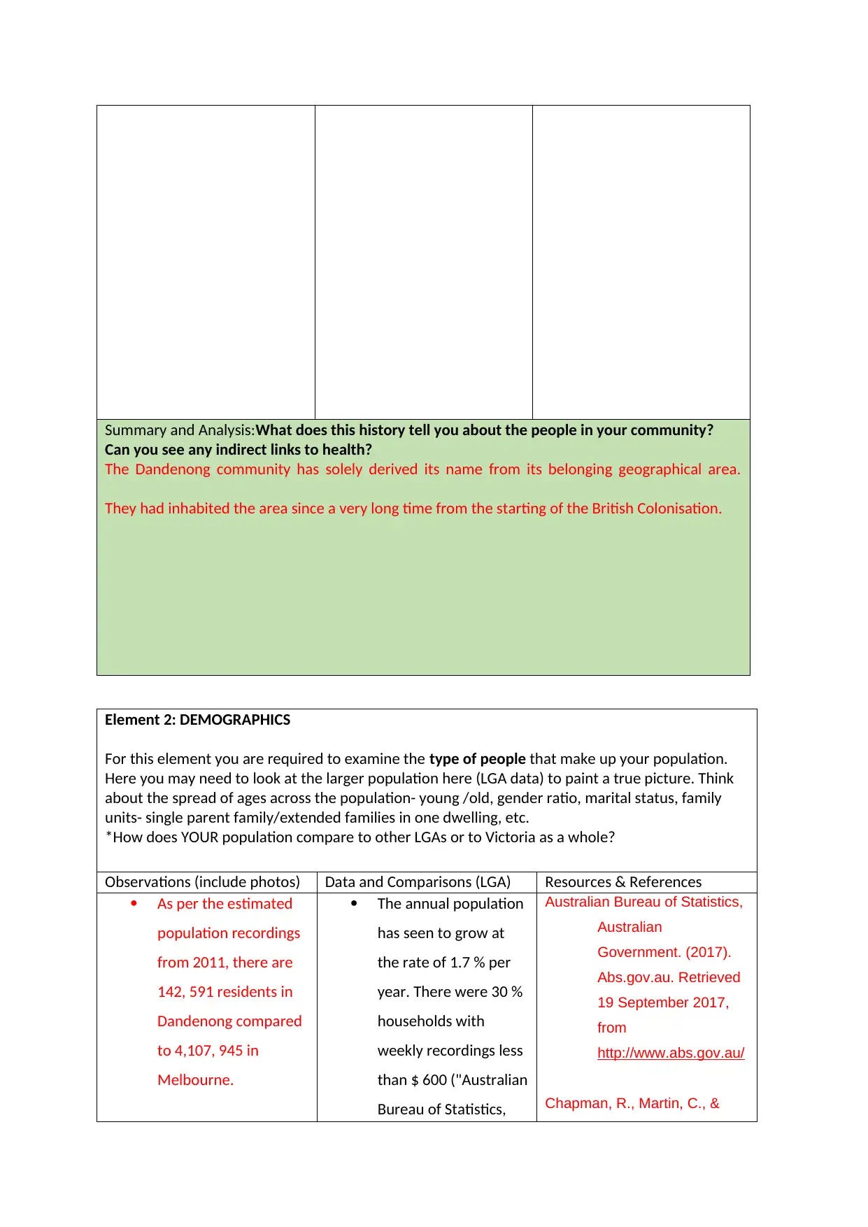
Summary and Analysis:What does this history tell you about the people in your community?
Can you see any indirect links to health?
The Dandenong community has solely derived its name from its belonging geographical area.
They had inhabited the area since a very long time from the starting of the British Colonisation.
Element 2: DEMOGRAPHICS
For this element you are required to examine the type of people that make up your population.
Here you may need to look at the larger population here (LGA data) to paint a true picture. Think
about the spread of ages across the population- young /old, gender ratio, marital status, family
units- single parent family/extended families in one dwelling, etc.
*How does YOUR population compare to other LGAs or to Victoria as a whole?
Observations (include photos) Data and Comparisons (LGA) Resources & References
As per the estimated
population recordings
from 2011, there are
142, 591 residents in
Dandenong compared
to 4,107, 945 in
Melbourne.
The annual population
has seen to grow at
the rate of 1.7 % per
year. There were 30 %
households with
weekly recordings less
than $ 600 ("Australian
Bureau of Statistics,
Australian Bureau of Statistics,
Australian
Government. (2017).
Abs.gov.au. Retrieved
19 September 2017,
from
http://www.abs.gov.au/
Chapman, R., Martin, C., &
⊘ This is a preview!⊘
Do you want full access?
Subscribe today to unlock all pages.
Trusted by 1+ million students worldwide
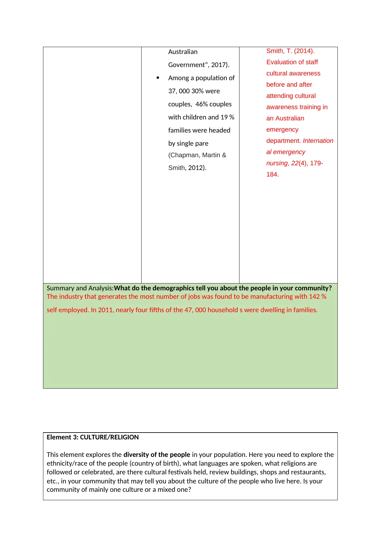
Australian
Government", 2017).
Among a population of
37, 000 30% were
couples, 46% couples
with children and 19 %
families were headed
by single pare
(Chapman, Martin &
Smith, 2012).
Smith, T. (2014).
Evaluation of staff
cultural awareness
before and after
attending cultural
awareness training in
an Australian
emergency
department. Internation
al emergency
nursing, 22(4), 179-
184.
Summary and Analysis:What do the demographics tell you about the people in your community?
The industry that generates the most number of jobs was found to be manufacturing with 142 %
self employed. In 2011, nearly four fifths of the 47, 000 household s were dwelling in families.
Element 3: CULTURE/RELIGION
This element explores the diversity of the people in your population. Here you need to explore the
ethnicity/race of the people (country of birth), what languages are spoken, what religions are
followed or celebrated, are there cultural festivals held, review buildings, shops and restaurants,
etc., in your community that may tell you about the culture of the people who live here. Is your
community of mainly one culture or a mixed one?
Paraphrase This Document
Need a fresh take? Get an instant paraphrase of this document with our AI Paraphraser
*How might this compare to other areas or to Victoria as a whole?
Observations (include photos) Data and Comparisons (LGA) Resources & References
The Dandenong
Community in the
Victoria region of
South East Australia
comprises of a
culturally missed
population.
The Dandenong region
provides a fusion of
culture and wide
variety of options to
the customers visiting
the shopping centres
and markets. The
Dandenong market
offers taste for every
season and
cherishable products
in very stall (Best et al.
2017).
The multidisciplinary
culture puts on equal
emphasis to different
religions and
particularly the
festivals (McCrea et al.
2015).
The region consists of
almost 52% of the
population who are
non-native English
speakers ("Australian
Bureau of Statistics,
Australian
Government", 2017).
Best, D., Irving, J., Collinson,
B., Andersson, C., &
Edwards, M. (2017).
Recovery networks
and community
connections: identifying
connection needs and
community linkage
opportunities in early
recovery
populations. Alcoholis
m Treatment
Quarterly, 35(1), 2-15.
Australian Bureau of Statistics,
Australian
Government. (2017).
Abs.gov.au. Retrieved
19 September 2017,
from
http://www.abs.gov.au/
McCrea, R., Foliente, G.,
Leonard, R., & Walton,
A. M. (2015).
Responding to change
in a growing
Melbourne: Community
acceptance, wellbeing,
and resilience. In State
of Australian Cities
Conference 2015:
Refereed Proceedings:
9-11 December 2015,
Gold Coast,
Queensland.
Summary and Analysis:How can the diversity of the population influence health?
Thus, being 35 km away from Melbourne’s CBD and being home to multiple cultures.
Fieldwork Workbook: weeks 3-4
Environment and Accessibility
Element4: PHYSICAL ENVIRONMENT
This element looks at the location and physical surrounds of this community. What climate does
this community have? What is the quality of the air, the water, etc.? What sort of topography is it
surrounded by? How accessible is the location (rural, remote, metro, etc) and what natural
disasters might it be prone to? What else can you tell me about the area or environment where
this community lives?
*How does this compare to other areas or to Victoria?
Observations (include photos) Data and Comparisons (LGA) Resources & References
The Dandenong range
consists of set of low
range mountains. The
climate experienced
by the region is mild
and wet with
temperature variation
typically low.
The connectivity of the
region is good with
the rest of the world.
The region is prone to
frequent incidents of
bushfires
The topography
consists of a series of
ridges dissected by
deeply cut streams
(D’Cruz et al. 2016).
The region is located
at a distance of 35 kms
from the major cities
of Australia such as
Victoria,
Melbourne("Australia
n Bureau of Statistics,
Australian
Government", 2017).
D’Cruz, G., McLeod, S., de Bruyn,
D., & McIntyre, S. (2016).
Dancing Dandenong: The
Poetics of Spatial
Politics. In Contemporary
Publics (pp. 77-95).
Palgrave Macmillan UK.
Australian Bureau of Statistics,
Australian
Government. (2017).
Abs.gov.au. Retrieved
19 September 2017,
from
http://www.abs.gov.au/
⊘ This is a preview!⊘
Do you want full access?
Subscribe today to unlock all pages.
Trusted by 1+ million students worldwide
Summary and Analysis:How can WHERE you live impact on the health of a population?
Due to the extreme climate experienced by the region frequent bushfires are experienced by the
region which impacts upon the vegetation type.
Element5: RECREATION
This element is where we look at how the surroundings are used by people. Does the area offer
special places for sport or activities? Who uses these spaces? What risks are involved in these
activities? Do people come from outside the community to use these resources? Do these
recreational resources cater for everybody? Disability access? Cultural/art/musical activities?
*How does this compare to other areas or to Victoria?
Observations (include photos) Data and Comparisons (LGA) Resources & References
Paraphrase This Document
Need a fresh take? Get an instant paraphrase of this document with our AI Paraphraser
The parks and the
playgrounds have been
well designed to cater
to the needs of the
disabled children or
audiences attending
the venues.
The cross cultural
communities promotes
rich cultural heritage.
The city of Dandenong
harbours 91 sporting
clubs and the at same
time promotes 18
different recreational
activities and sports. In
addition, to the
estimated list of
playgrounds for
children there are 100
parks, 4 bushland
areas.
Additionally, as
commented by Joshi
et al. (2013), the 54
kms wide biking path
of the Dandenong
community provides
greater relaxation
opportunities for the
local community.
Around 600 acres of
public parks are
accessible for children
and the local citizens.
Joshi, C., Russell, G., Cheng, I.
H., Kay, M., Pottie, K.,
Alston, M., ... & Wahidi,
S. S. (2013). A
narrative synthesis of
the impact of primary
health care delivery
models for refugees in
resettlement countries
on access, quality and
coordination. Internatio
nal journal for equity in
health, 12(1), 88.
Summary and Analysis:How dothe activities that are undertaken in this community impact the
health of its people?(Inclusive, accessible and affordable, risks/benefits?)
The region promotes 5 premier sports reserves hosting a wide range of sports events.
Element6:MOBILITY and TRANSPORTATION
For this element we look at how people move around this community. We modes of transport
(private and public), roads (quality, type, amount of traffic, etc), footpaths, walking/bike tracks and
so on. We think about issues such as cost, time of day, availability, who uses them- young/old,
disabled, mothers with prams, etc?
*How does this compare to other areas of Victoria?
Observations (include photos) Data and Comparisons (LGA) Resources & References
The suburbs of
Dandenong are well
connected to the rest
of the cities with the
introduction of smart
bus services.
As mentioned by
Oldroyd et al. (2017),
the presence of 52 kms
wide biking tracks
allows for free and
comfortable
movement reducing
the chances of
congestion due to
heavy vehicles.
There are vast and
open spaces available
to mothers for freely
moving around with
their babies or in the
pram("Australian
Bureau of Statistics,
Australian
Government", 2017).
Oldroyd, J. C., White, S.,
Stephens, M., Neil, A.
A., & Nanayakkara, V.
(2017). Program
Evaluation of the Inner
South Community
Health Oral Health
Program for Priority
Populations. Journal of
Health Care for the
Poor and
Underserved, 28(3),
1222-1239.
Australian Bureau of Statistics,
Australian
Government. (2017).
Abs.gov.au. Retrieved
19 September 2017,
from
http://www.abs.gov.au/
⊘ This is a preview!⊘
Do you want full access?
Subscribe today to unlock all pages.
Trusted by 1+ million students worldwide
Summary and Analysis:How does mobility or transport impact on health within your community?
Dandenong is well connected with the rest of the major cities of the Australian continent. It
consists of a number of well connected rail routes at Dandenong, yarrman, Sandwon Park and
Springvale.
Fieldwork Workbook: weeks 5-6
Socioeconomic State and Connection
Element 7: ECONOMY
This element addresses the financial and employment state of the community and its population.
You will explore employment rates, types of workforce and industry, income rates, etc. This might
include data about housing (own/renting, homeless), single/double income families,
retirees/pensions, etc.
*How does this compare to other areas or to Victoria?
Observations (include photos) Data and Comparisons (LGA) Resources & References
Paraphrase This Document
Need a fresh take? Get an instant paraphrase of this document with our AI Paraphraser
As mentioned by
Osborne et al. (2013),
the majority of the
recruitments
happening in the
manufacturing
industries.
As per the detailed
reports and
assessment around
152 % of the
population belonging
to the Dandenong
suburban region are
self-employed
(Oldroyd et al. 2017).
The median annual
income of males have
been found to be 58 %
higher than that of the
females("Australian
Bureau of Statistics,
Australian
Government", 2017).
Oldroyd, J. C., White, S.,
Stephens, M., Neil, A.
A., & Nanayakkara, V.
(2017). Program
Evaluation of the Inner
South Community
Health Oral Health
Program for Priority
Populations. Journal of
Health Care for the
Poor and
Underserved, 28(3),
1222-1239.
Australian Bureau of Statistics,
Australian
Government. (2017).
Abs.gov.au. Retrieved
19 September 2017,
from
http://www.abs.gov.au/
Summary and Analysis:How can the socioeconomic status of your community impact on the
health of the population?
The percentage of population with a per day income of less than 6 Australian dollars is
30%.
The rate of double income families is only about 15% compared to 46% for single income
families.
Element 8: EDUCATION
This element explores the level and type of education within the community. This includes private
or public, what level students leave study, attrition rates, what extra curriculum activities the
education facilities offer and so on. You need to consider all levels of education; from
preschool/childcare (early childhood) through to tertiary education or trade qualifications.
*How does this compare to other areas or to Victoria?
Observations (include photos) Data and Comparisons (LGA) Resources & References
The education facilities
through connected
with different
extracurricular
activities such as
theatre and music only
4% people have been
seen to avail of such
extended networks.
.
Estimates shows that
almost 8475 number
of students had been
dropped out of
secondary schools
whereas only 20% had
been attending
secondary schooling.
Therefore, reducing
the literacy rates on a
much wider platform.
As per the census of
2011, 13% of the
students had left
school even before
completion of the 11th
standard.
The percentage of
students attending
tertiary education is
only 23% compared to
29% percentage in
Melbourne (ABS,
2017).
Australian Bureau of Statistics,
Australian
Government. (2017).
Abs.gov.au. Retrieved
19 September 2017,
from
http://www.abs.gov.au/
⊘ This is a preview!⊘
Do you want full access?
Subscribe today to unlock all pages.
Trusted by 1+ million students worldwide
1 out of 24
Related Documents


Your All-in-One AI-Powered Toolkit for Academic Success.
+13062052269
info@desklib.com
Available 24*7 on WhatsApp / Email
![[object Object]](/_next/static/media/star-bottom.7253800d.svg)
Unlock your academic potential
Copyright © 2020–2026 A2Z Services. All Rights Reserved. Developed and managed by ZUCOL.