Earth Science Assignment: Geological History Analysis Report
VerifiedAdded on 2021/09/16
|8
|1159
|161
Report
AI Summary
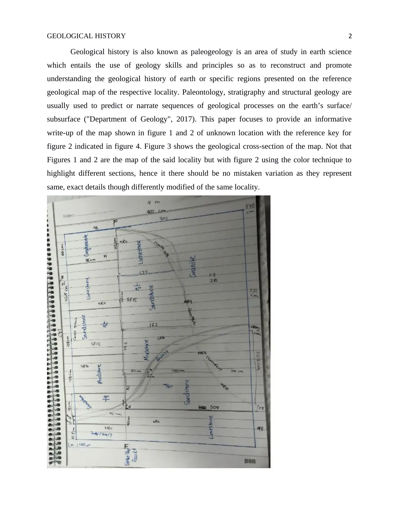
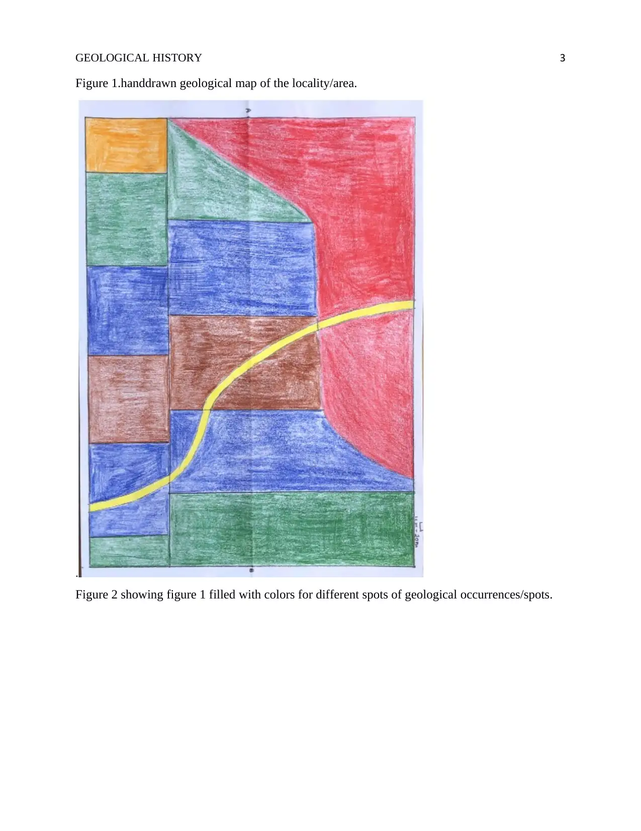
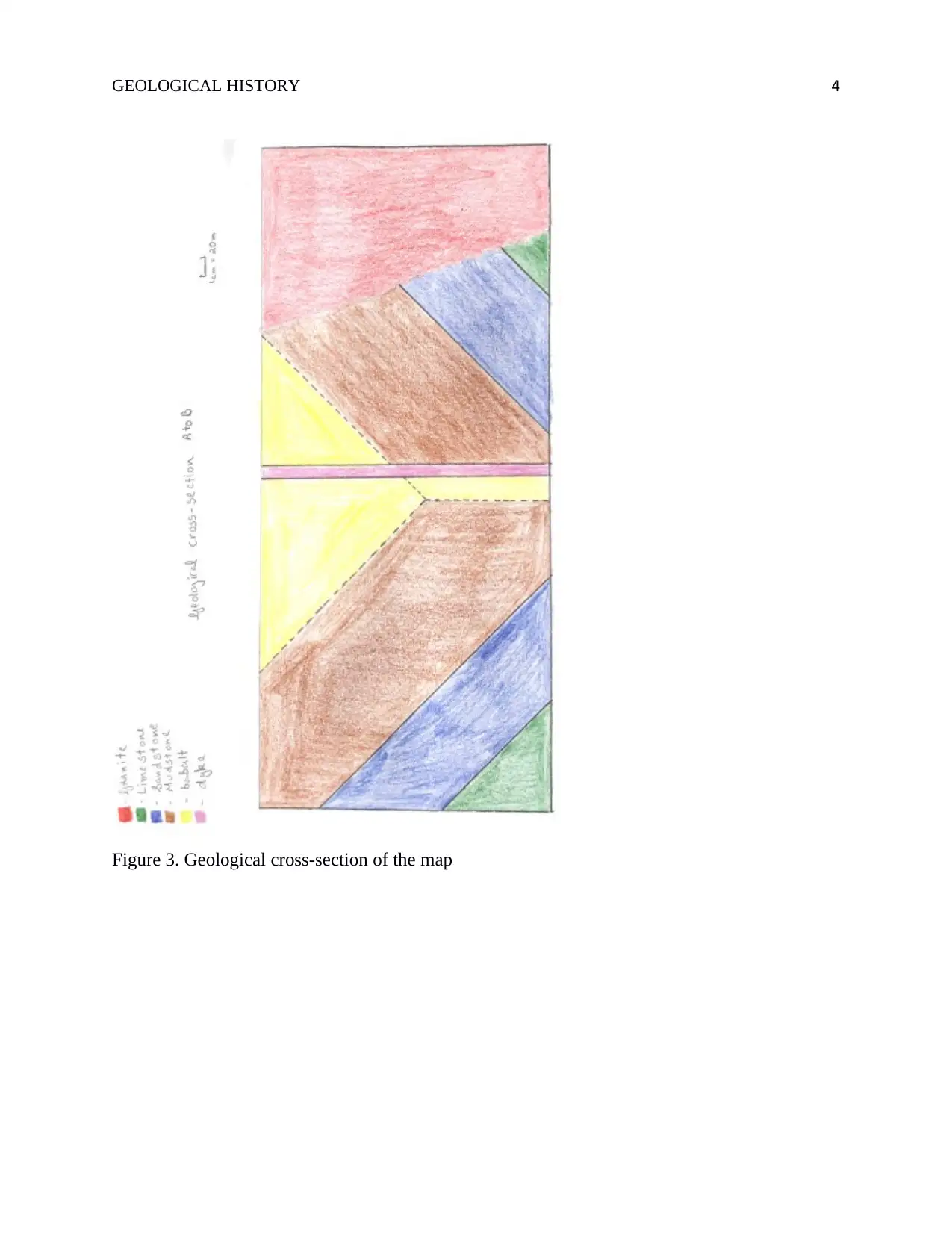
This report provides an analysis of a geological map, detailing the geological history of an unknown locality. The analysis includes descriptions of various rock formations such as conglomerate, limestone, sandstone, mudstone, granite, quartzite, marble, and hornfel. The report explores the characteristics and formation processes of each rock type, including their sedimentary, igneous, and metamorphic origins. The spatial distribution of these rocks on the map, along with the geological cross-section, allows for interpretations about the area's past environment, suggesting the presence of both marine and terrestrial environments, including a subduction zone or tectonic convergent boundary. The report utilizes the principle of cross-cutting relationships to infer the relative ages of different rock formations and concludes with an overview of the area's geological history based on the map and cross-section data.

Running head: GEOLOGICAL HISTORY 1
Earth Science
First Second Name
Institution
Earth Science
First Second Name
Institution
Paraphrase This Document
Need a fresh take? Get an instant paraphrase of this document with our AI Paraphraser

GEOLOGICAL HISTORY 2
Geological history is also known as paleogeology is an area of study in earth science
which entails the use of geology skills and principles so as to reconstruct and promote
understanding the geological history of earth or specific regions presented on the reference
geological map of the respective locality. Paleontology, stratigraphy and structural geology are
usually used to predict or narrate sequences of geological processes on the earth’s surface/
subsurface ("Department of Geology", 2017). This paper focuses to provide an informative
write-up of the map shown in figure 1 and 2 of unknown location with the reference key for
figure 2 indicated in figure 4. Figure 3 shows the geological cross-section of the map. Not that
Figures 1 and 2 are the map of the said locality but with figure 2 using the color technique to
highlight different sections, hence it there should be no mistaken variation as they represent
same, exact details though differently modified of the same locality.

GEOLOGICAL HISTORY 3
Figure 1.handdrawn geological map of the locality/area.
.
Figure 2 showing figure 1 filled with colors for different spots of geological occurrences/spots.
Figure 1.handdrawn geological map of the locality/area.
.
Figure 2 showing figure 1 filled with colors for different spots of geological occurrences/spots.
⊘ This is a preview!⊘
Do you want full access?
Subscribe today to unlock all pages.

Trusted by 1+ million students worldwide

GEOLOGICAL HISTORY 4
Figure 3. Geological cross-section of the map
Paraphrase This Document
Need a fresh take? Get an instant paraphrase of this document with our AI Paraphraser

GEOLOGICAL HISTORY 5
Figure 4. Key for the maps in figures 3 &4.
From the far top, left corner occurs the conglomerate spanning within 95 cm by 66 cm on the
map (9500m by 6600 m on the actual ground). Conglomerate consists of significant portions of
subangular to rounded clasts of gravel-size (Trundle, 2015). The conglomerate is a sedimentary
rock coarse-grained and clastic nature with sizes of individual portions exceeding 2 mm. For it to
occur in the map indicate that the area within which it occurs is characterized by strong water
currents which play a significant role in the transportation of the particles and the rounded shape
of particles. Therefore, the surrounding zone of deposition hence occurrence of this type of rock
is along a swiftly flowing stream or a beach characterized by resilient waves.
Limestone occurs at 4 different regions within the map. At one of these regions, it borders a line
of occurrence of marble which based on the principle of cross-cutting relationships indicated that

GEOLOGICAL HISTORY 6
marble developed much later after the occurrence of the limestone or bordering rocks it cuts
across. Limestone is a sedimentary rock composed significantly of calcium carbonate (mineral
calcite) (Documentary, "Geological History Of Earth - Geological History Documentary", 2016).
Ideally, limestone occurs in shallow, clear, warm marine waters. Being an organically
sedimentary rock, it is formed from amassing of algal, shell, fecal and coral debris. These areas
would seem to be basically lying within marine waters hence the occurrence of the limestone, at
least at one point in time during their formation.
Sandstone also happens to occur in 4 different regions as indicated in the figures above. In two of
such regions it is traversed by basalt rock at widths not exceeding 17 cm; indicating that it is
older than the basalt occurring across it sections based on the principle of cross-cutting
relationships. Sandstone is a sedimentary rock comprising of a matrix of silt or clay size particles
bound together as a resulting of its cementing properties (Trundle, 2015). It is characterized by
remarkable resistance and hence its ability to serve as groundwater aquifers as well as/ or natural
gas and oil reserves in the subsurface. Based on the cross sections of the geology provided, it is
much likely that forms the groundwater aquifer or a reservoir of oil and natural gas.
Mudstone is characterized by a combination of silt and clay-sized particles and is significantly
extremely fine-grained sedimentary rock. Mudstone forms from compaction by overlying
sediment of small particles that settle at the ocean bottoms, lagoons, the floor of lakes and quiet
stretches of rivers (Park, 2014).
Granite occurs extensively and continuously relative to other individual rock type’s occurrences
on the map as shown in the figures 1 and 2. Granite is an igneous rock consisting of feldspar and
quartz with insignificant levels of amphiboles, mica minerals. Granite forms as a result of
dawdling crystallization of magma underneath the surface of the earth ("Igneous Rocks:
Formation Texture and Composition | Geology", 2016). Based on the geological cross-section on
figure 4, it occurs across the rock layer with the edges of the existing rocks as it does not occur in
layers.
Evidently, there occur traces of quartzite, marble and hornfel rocks. Hornfel rocks are
metamorphic rock formed as a result of contact between clay-rich rock or mudstone/ shale and
hot igneous rock hence it occurrence between granite and sandstone as shown in the figures
above. Quartzite forms from sandstone through metamorphism due to compression of tectonic
plates within the orogenic belts (Bowman, 2015). Marble on the other hand forms from
⊘ This is a preview!⊘
Do you want full access?
Subscribe today to unlock all pages.

Trusted by 1+ million students worldwide

GEOLOGICAL HISTORY 7
limestone by thermos-dynamic metamorphism. Form this understanding, it can be noted that
there exist a subduction zone or a tectonic convergent boundary in the area covered by the map;
specifically where marble and quartzite occur in the map.
Conclusion
In summary, the map spans an area within massive water mass, for instance, an ocean or Quiet
River but precisely an ocean hence a marine water system. Also, the area is characterized by
quiet waters at some points to facilitate deposition with a section of the area close to the
shoreline characterized by strong water currents hitting the shore where conglomerate rock
occurs. Lastly, there exists either a subduction zone or tectonic convergent boundary within the
area represented on the map.
Paraphrase This Document
Need a fresh take? Get an instant paraphrase of this document with our AI Paraphraser

GEOLOGICAL HISTORY 8
References
Bowman, C. (2015). Rocks. Minneapolis, MN: Bellwether Media.
Igneous Rocks: Formation Texture and Composition | Geology. (2016, October 20). Retrieved
November 9, 2018, from
http://www.yourarticlelibrary.com/geology/igneous-rocks/igneous-rocks-formation-
texture-and-composition-geology/91378
Park, G. (2014). The making of Europe: A geological history. Edinburgh, Scotland: Dunedin.
Trundle, K. C. (2015). Earth science. Menasha, WI: National Geographic Learning.
Documentary, B. (2016, December 12). Geological History Of Earth - Geological History
Documentary. Retrieved November 9, 2018, from https://www.youtube.com/watch?
v=_UuDFkXxEnI
Department of Geology. (2017). Retrieved November 9, 2018, from
https://www.uvm.edu/cas/geology
1 out of 8

Your All-in-One AI-Powered Toolkit for Academic Success.
+13062052269
info@desklib.com
Available 24*7 on WhatsApp / Email
Unlock your academic potential
Copyright © 2020–2025 A2Z Services. All Rights Reserved. Developed and managed by ZUCOL.