Detailed Environmental and Infrastructure Report: M-4 Motorway Project
VerifiedAdded on 2022/03/24
|14
|4296
|22
Report
AI Summary
This report details the M-4 Motorway Extension Project, a significant infrastructure initiative aimed at enhancing trade and connectivity within Pakistan and with Central Asian Republics. The project involves constructing a four-lane access-controlled dual carriageway from Faisalabad to Khanewal, with an extension to Multan. The report examines the project's components, including road design, interchanges, and related infrastructure, as well as the environmental impact assessment, considering factors such as air quality, noise, hydrology, and ecological resources. The project area's physical environment, including climate, soil, and seismicity, is analyzed, alongside agricultural and industrial activities. The report highlights the baseline environmental conditions and potential impacts, providing a comprehensive overview of the project's scope and implications. The document also provides information on land acquisition, construction work and potential environmental concerns during the operation phase of the motorway.
The Transport Infrastructure Needs Improvement
GENERAL:
This is a project of national importance, which aims to improve the transport infrastructure by
constructing a new four-lane access-controlled dual carriageway with a barrier in the centre. The
length of M-4 from Faisalabad to Khanewal is 184 kms and proposed M-4 extension is 42 km
designed for 120 km/hr speed facility. The civil works will involve construction of four new
lanes, fence, grade-separated interchanges, under passes, toll plazas, rest/service areas, flyovers
etc. Total formation width of the proposed expressway will be 24.2 metres.
Prime objectives of the proposed Project are to:
Enhance trade activities in the country;
To provide in future the trade linkage of Central Asian Republics with Pakistan.
Provide safe, high speed and time saving corridor to the travellers;
Enhance the efficiency of road network; and
Reduce the number of accidents.
The existing environment in the Project Area has been studied with respect to physical,
ecological, cultural and socio-economic aspects. The data collection for M-4 extension was
carried out during month of June 2009
At present, there are mostly agricultural fields on site of the proposed Project; therefore baseline
environment of the Project Area is free from environmental pollution such as dust, noise or
vehicular emissions. This will allow the determination of baseline conditions against which the
incremental impact of the proposed Project will be assessed. Human impacts such as road safety,
traffic noise, vehicular emissions and other types of associated pollution are taken into
consideration for the operational stage of the proposed Project. These factors are therefore
discussed as part of the baseline environmental conditions in the Project Area.
LOCATION OF THE PROPOSED PROJECT
1 | P a g e
Paraphrase This Document
Need a fresh take? Get an instant paraphrase of this document with our AI Paraphraser
The proposed Faisalabad-Khanewal section falls under the administrative jurisdiction of
Faisalabad, Toba Teksingh and Khanewal districts while proposed M-4 extension falls under
jurisdiction of Khanewal and Multan districts. The proposed M-4 extension will start at near
Moza Shamkot and end at Multan-Bahawalpur road 7 km towards Bahawalpur from Multan.
presents the location of the proposed Project.
The cities, towns and major settlements falling en-route the M-4 extension Project are Khanewal,
Qadirpur ran, Tatepur, Kotheywal, and Multan. The RoW of the proposed Project contains
mostly agricultural land.
PROJECT COMPONENTS
The carriageway will include paved width of 24.2m with shoulders at inner and outer side. The
outer shoulder of each carriageway will be 3 meters wide with 0.5 meter rounding and the inner
side will be 0.6 meter.
The Right of Way (RoW) of the proposed Motorway Project is 100 meters up to Khanewal and
80 m onwards up to Multan, while it will be 300 meters at the locations where interchanges will
be constructed. The cross section of entire M-4 will remain unchanged. Only the area reserved
for future lane and plantation will vary as it will be 32.9m wide on either side of paved portion
up to Khanewal and 22.9m on either side for M-4 extension. Major construction work will
generally remain confined within the RoW. About 850 acres of land will be acquired for the
proposed Extension.
PHYSICAL ENVIRONMENT
The climate of the Project Area touches two extremes, characterised by hot summers and mild
winters. From April onwards, the summer season continues usually up to the middle of October
after which it becomes cool and the day temperature also begins to recede. May, June and July
are the hottest months. The winter season on the other hand starts from November and continues
till March. December, January and February are coldest months.
2 | P a g e
The mean maximum and minimum temperature in summer are 42oC and 27oC respectively and
in winter 28oC and 4oC respectively. .
The Project Area has very few rainfalls. The summer season continues from July to September
and the winter season from December to April. The bulk of monsoon precipitation occurs in July
and August, with monthly averages of 115.0 and 89.8 mm respectively. Minimum rainfall occurs
in the month of November, which is 3.0 mm.
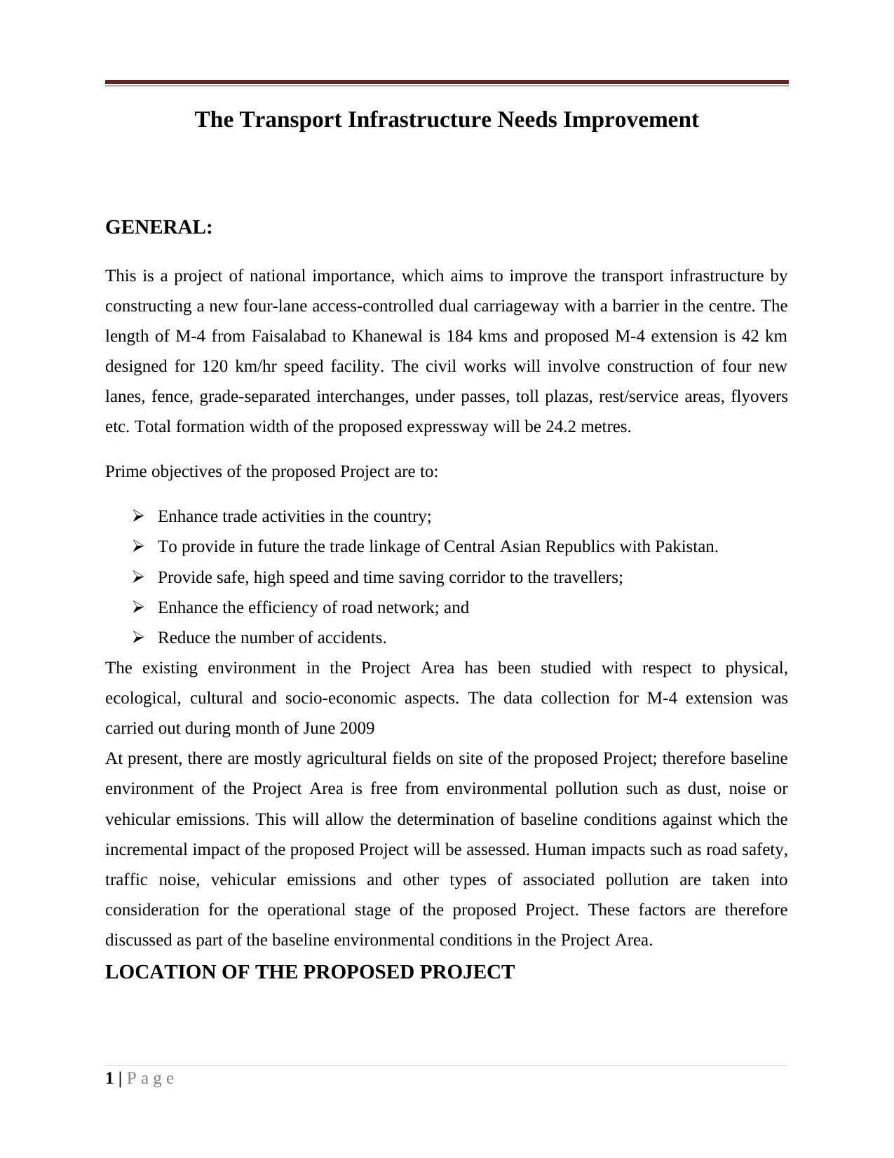
AIR QUALITY
The air quality in the Project Area is mostly free from pollutants except dust on the existing
roads where interchanges and flyovers are proposed. A lot of dust occurs due to dry atmosphere
and the situation gets aggravated by the human activity. Large amount of suspended particulate
matter (SPM) is generated when the vehicles move (to overtake other vehicles) on unpaved
shoulders of these roads. The proposed Project will not cause any dust problem due to smooth
road surface and paved shoulders.
NOISE
As the existing status of the Project area is mostly agricultural fields and some road crossings
therefore noise level exceeds only at road crossings. The average value of noise along the road
crossings close to NEQS and WHO limits and is expected that in the construction and operation
phase this will go beyond limits. Roadside noise levels were measured from the edge of the road
3 | P a g e
in winter 28oC and 4oC respectively. .
The Project Area has very few rainfalls. The summer season continues from July to September
and the winter season from December to April. The bulk of monsoon precipitation occurs in July
and August, with monthly averages of 115.0 and 89.8 mm respectively. Minimum rainfall occurs
in the month of November, which is 3.0 mm.
AIR QUALITY
The air quality in the Project Area is mostly free from pollutants except dust on the existing
roads where interchanges and flyovers are proposed. A lot of dust occurs due to dry atmosphere
and the situation gets aggravated by the human activity. Large amount of suspended particulate
matter (SPM) is generated when the vehicles move (to overtake other vehicles) on unpaved
shoulders of these roads. The proposed Project will not cause any dust problem due to smooth
road surface and paved shoulders.
NOISE
As the existing status of the Project area is mostly agricultural fields and some road crossings
therefore noise level exceeds only at road crossings. The average value of noise along the road
crossings close to NEQS and WHO limits and is expected that in the construction and operation
phase this will go beyond limits. Roadside noise levels were measured from the edge of the road
3 | P a g e
⊘ This is a preview!⊘
Do you want full access?
Subscribe today to unlock all pages.
Trusted by 1+ million students worldwide
(about 7.5 m from the source). Average noise level along the road is between 40 – 67 dB(A),
whereas peak noise level is between 61 – 100 dB(A).
HYDROULOGY OF AREA
SURFACE WATER AND GROUNDWATER
The main sources of water in the Project Area are Ravi River and Chenab River. The Jhang
Branch, Guggera Branch and Burala Branch are the major irrigation system for the Project area.
This system irrigates the land of the Project Area in Faisalabad, Jhang and Toba Tek Singh
districts, where as the Project Area in Khanewal district is irrigated through Sadhnaicanal and
Abdul Hakeem distributary. The Sadhnai canal and Abdul Hakeem Distributary are very
important sources of irrigation in Khanewal district. The proposed Motorway will cross Ravi
River and Sadhnai Canal at 145+250 Km and 145+900 Km respectively.
Small scale waterlogging and salinity problems were also observed in the Project Area in
Khanewal district, but none of these areas comes in the Motorway alignment. These waterlogged
and saline areas are more than one kilometrefar from the Motorway alignment.
GEOLOGY OF AREA:
TOPOGRAPHY AND SOIL
Topography of the M-4 extension same as of M-4 up to Khanewal. The topography is flat with
mild slope from North to South. Project Area is 500 metre above the mean sea level. The soil of
all four districts is fertile. The soil in the Project Area is rich alluvial loam. In Jhang district soil
is part of Sandal Bar except rock that is not in Project Area. The sand is abundant in Ravi and
Chenab river bed and this sand is superior for building material.
Flooding
During construction the topsoil and vegetation cover have to be removed which leads to a
slight increase in permeability of soil and thus causes a reduction in run-off coefficient.
However, this effect is likely to be compensated for by the effects of soil compaction.
The consequent effect on the volume of surface run-off is therefore negligible.
SEISMICITY
4 | P a g e
Paraphrase This Document
Need a fresh take? Get an instant paraphrase of this document with our AI Paraphraser
According to the seismic zoning map of Pakistan, the Project Area lies in Zone 1 of Modified
Mercalli (M.M.) intensity scale, i.e. minor damage. Distant earthquakes may cause damage to
structures with fundamental period greater than 1.0 second, corresponds to intensity V and VI of
the M.M.
AGRICULTURE AND CROP PATTERN
Agriculture along M-4 is predominantly irrigated agriculture. The Project Area depends on
perennial canals from Sagir Head Works, Abdul Hakeem Head Works and Rangor Head Works.
The shortage of water is generally experienced in winter and in sowing season it greatly hampers
Kharif cultivation.
The Project Area of M-4 Motorway passes through five districts. Cropping patterns in these
districts are slightly different from each other. Table 3.8 represents the major crops for respective
Districts of the Project Area. In the area from Khanewal to Multan Mango orchards are
abundant, while Cotton, Rice, Chillies, Fodder, Wheat, Gram, Sunflower are the major crops of
the area.
INDUSTRIAL AND COMMERCIAL ACTIVITIES
The route of M-4 has been designed through agriculture fields therefore chances of commercial
units along the route are negligible. Faisalabad the starting point of M-4 is famous for its textile
industries. In districts of Toba Tek Singh and Jhang, very little commercial units i.e. only a few
sugar mills and spinning. In Khanewal district Rosh Power Plant, a hatchery and pesticide
factory. Multan has its separate industrial area with versatile industries. All the industrial units in
the Project Area are at safe distance from the alignment.
ECOLOGICAL/BIOLOGICAL RESOURCES
FLORA
The Project Area falls under the Tropical Thorn Forest however, the natural vegetation has been
replaced by the agricultural crops. Major crops grown in the area include wheat, oilseeds and
fodder during winter, and sugar cane, maize, rice, fodder, and cotton in summer.
5 | P a g e
Trees: Citrus and guava orchards are common towards the north eastern side, replaced by mango
orchards towards south western end. Tree plantation campaigns have motivated the farmers to
grow trees along the field borders or along the water channels. A total of 18000 non fruit trees
were estimated to be growing in the project area up to Khanewal and 16899 trees comprising
8660 fruit and 8239 non fruit trees are growing in corridor of M-4 extension.NATURAL
VEGETATION:
Natural vegetation including Karir (Capparis aphylla), Aak (Calotropis procera), Kana
(Saccharum bengalensis), Khabbal (Cynodondactylon), Lamb (Aristida depressa), Gorkha
(Lasiurus sindicus) is present only in the graveyards or at open areas along the existing roads and
canals. Mesquit (Prosopis glandulosa) has invaded many open areas. Koondar (Typha angustata)
grows along water ponds and wet places.
FAUNA
MAMMALS
Naturally occurring mammals have also been eradicated with the removal of natural Tropical
Thorn Forests only the agriculture associated species remain. Jackal (Canis aureus), Mongoose
(Herpestesedwardsi and H. javanicus), Jungle cat (Felis chaus), Hedgehog (Hemiechinuscollaris)
and Five striped Palm squirrel (Funambuluspennantii) commonly occur. Porcupine ( Hystrix
indica) also occurs in the area. Small mammals including Bandicoot or Indian mole rat
(Bandicota bengalensis), Soft furred rat (Millardiameltada), Field mouse (Mus musculus), Indian
gerbil (Tatera indica), and House shrew (Suncus murinus) are the common pests of agricultural
crops.
Domestic livestock include buffalo, cattle, goats and sheep. Donkeys are kept to pull carts in the
area. Some farmers are also engaged in horse breeding. Camel may be found occasionally.
Livestock are mainly farm fed. Goats and sheep herds may be raised by feeding on wastelands.
REPTILES
House gecho (Hemidactylus brooki) is common. Common tree lizard (Calotes versicolor
versicolor) may also occur in orchards. Monitor Lizard (Varanus bengalensis) and Fat tailed
6 | P a g e
⊘ This is a preview!⊘
Do you want full access?
Subscribe today to unlock all pages.
Trusted by 1+ million students worldwide
lizard (Uromastixhardwickii) occur in open areas. Two species of fresh water turtles viz., Indian
soft–shell (Aspideretes gangeticus), and Indian flapshell (Lissemys punctata andersoni) have
been reported. They are usually present near the ponds, canals and in the fields during the wet
season.
AMPHIBIANS
Bullfrog (Hoplobatrachustigerinus), Pahari tiddamaindak (Fejervaryalimnocharis) and Indus
valley toad (Bufo stomaticus) are also present in the area.
BIRDS
Intensive use of agriculture pesticide is a common practice in the Project Area. This has
impacted the bird populations adversely. Black and Grey partridges (Francolinusfrancolinus and
F. pondicerianus), are the worst hit as they are also hunted and captured to be kept as pets.
Species known to occur in the area are: Cattle egret (Bubulcus ibis), pond heron (Ardeolagrayii),
Common and Bank myna (Acridotheres tristis and A. ginginianus), Red vented bulbul
(Pycnonotuscafer), Jungle babbler (Turdoidesstriatus), Blyth’s reed warbler (Acrocephalus
dumetorum), Indian great reed warbler (A. stentoreus), Black kite (Mivusmigrans), Black
shouldered kite (Elanus caeruleus), Koel (Eudynamysscolopacea), Black drongo or King crow
(Dicrurusmacrocercus) Common crow (Corvus splendens), and house sparrow (Passer
domesticus). Common quails (Coturnix coturnix) visit the area on their spring and winter
migration.
AQUATIC BIOTA
Aquatic fauna reported from therivers and canals of the Project Area is mainly fish, which
include the carp fishes The welfare of fish depends on the availability of food which occurs in
the form of invertebrate groups including Rotifers. The fauna is similar to that found in the fish
farms established in central Punjab and in standing water.
The aquatic flora in the Project Area consists of species usually found in the standing water
along the canals and fish ponds.No rare or endangered species occur in the Project Area.
Air Quality
7 | P a g e
Paraphrase This Document
Need a fresh take? Get an instant paraphrase of this document with our AI Paraphraser
The emission of pollutants by vehicles has worldwide impacts and contributes greatly to
the total atmospheric pollution generated by people. The use of passenger cars alone is
responsible for 60 percent of carbon monoxide emissions, 60 percent of hydrocarbon
emission, and more than one-third of the nitrogen released into the atmosphere. Clearly,
pollution by motor vehicles plays a significant role in a serious global problem.
The level of effort and degree of urgency for air quality assessment should be related to
PEPA standards and local conditions. Where motor vehicles are a major source of the
problem, or are likely to be one, air quality assessment is essential.
The main products of the combustion of motor fuels are carbon dioxide and water, but
inefficiencies and high temperatures inherent in engine operation encourage the production of
many other pollutants of varying effect.
EXISTING LAND USE
The land along the M-3 route is uninhabited substantially except small rural settlements
located 500 to 800 m away from the ROW. There are vast agricultural activities around
the project area. As good quality groundwater is available for agriculture. Therefore,
major land use of the area is agriculture. Other land uses in the vicinity of the project area
are residential settlements and roads. Hotels, petrol pumps, shopping area, river, water channels
etc., are not found along the M-3 route.
Agriculture
The land along the M-3 route is mostly cultivated. (About 90% land is agricultural). In
villages, people are engaged in cultivation mainly for the domestic and commercial
consumption. The survey also revealed that the cultivated land produces a high yield.
Sugar cane, wheat, corn, cotton and rice are grown mainly. Vegetables and seasonal fruits
are also grown in this area.
Recreational Areas/Open Spaces
No green spaces, parks, national parks or forests are found in the vicinity of the proposed
M-4 that could be used for tourism and recreational purposes
SOCIO-ECONOMIC ENVIRONMENT
Motorway passes from rural areas of the Punjab and socio cultural conditions of all districts are
almost same. Most of the people living in the surrounding villages are farmers, Punjabi is their
mother tongue. In some areas Saraiki is also spoken as mother tongue. In almost all areas dress
patron is same, Shalwar kameez and dothi kurta are the common dresses of males and females.
Some modern young males also wear pants and shirts. The history of colonization exercised a
profound influence on socio-economic pattern of the areas. People belong to different races but
due to frequent inter-marriages, these castes have intermingled and it is now difficult to
distinguish their entity and thus tribal system is no more dominated in the culture. In fact a
common culture has emerged. Most of the people are engaged in agriculture or agro based
businesses. Almost all the land holders’ families have landholding size around 10 Acres
therefore they belong to lower middle class. The socioeconomic information for extension of M-
8 | P a g e
4 is collected through the survey conducted between January 2007 and February 2007 and in
May 2009 to June 2009 for Khanewal Multan Section.
POPULATION PROFILE OF THE AREAS
Total population of the areas by which the route passes as, Sadar Tehsil of Faisalabad is 924,110
with a growth rate of 1.94%. ThesilGojra district Toba Tek Singh has a population of 495,096
with a growth rate of 1.94%. Tehsil Toba Tek Singh has population of 617,035 with a growth
rate of 2.07%. Tehsil Shorkot of district Jhang has a population of 670,255 with a growth rate of
2.23% as recorded in 1998 Census. The areas which are adjacent to the extended portion of the
project, from Khanewal to Multan have following demographic profile.
SETTLEMENT PATTERNS
M-4 starts from Faisalabad district and ends in Multan district. It passes from tehsil areas of
Faisalabad, Gojra, Toba Tek Singh, Shorkot, Kabirwala, Khanewal and Multan. In rural areas of
tehsils Kabirwala, Khanewal and Multan, there is no formal pattern of villages establishing and
people make their homes in their agriculture lands which is colloquially called Dera or Bhani.
INDIGENOUS PEOPLE
Although people living around Khanewal and Multan belong to different races and tribes and
have different cast pattern but there is no community identified who has “close culture, close
economy and close community” (Confined to a limited area). Therefore no any indigenous
community exists and there is no danger of elimination or affecting negatively of any community
by the proposed project execution.
RELIGION
Religion plays a vital role in people’s life. Majority of the Project Area population is Muslim.
Cultural festivals are mostly related with religious traditional events. Visit to the shrines (termed
as Ziarat) is a very common among people. Only minority identified are Christian in the areas
which are less than 1 percent.
SOCIO ECONOMIC:
9 | P a g e
⊘ This is a preview!⊘
Do you want full access?
Subscribe today to unlock all pages.
Trusted by 1+ million students worldwide
Communities and their Economic Activity
Communities owe much of their vitality to the ease with which economic and social
interactions take place. Ironically, while roads are central to this continuing interaction,
the introduction of a new road, or the widening of an existing road, may well cause
disruptions to local interactions which outweigh the benefits. With poor planning, this
can be as true of the local road improvement as it is of the new highway. Properly
planned, however, both should bring benefits to surrounding communities; for example
through lower transport costs, better access to markets, goods, jobs, or services such as
health and education. Admittedly, in the case of some major highways and freeways, the
benefits may accrue mainly to long-distance travelers and haulage companies and their
customers, while benefits to the local community may be minimal. Proper planning calls
for recognition that road projects can lead to modifications in the community
environment surrounding the road, influencing various aspects of lifestyles, travel
patterns, and social as well as economic activities. Recognizing and planning for the
management of these impacts is an important aspect of the environmental assessment of
roads
Displacement and Resettlement
The land acquired by M-4 is agricultural land and no residential area (village/town) was
disturbed by the route, during construction phase. According to NHA, the acquired
agricultural land is purchased from the owners at a rate higher than the market rate.
Pedestrian Underpasses
M-4 motorway has cut the access to same villagers; some individuals may have their
houses on one side and their estates on other side. Although for 52.5 Km length of
project, 51 numbers of subways (under-passes) have been designed (about one subway
after one Km), but location of these subways will have some impact on living and
housing trend of the area.
Indigenous People
Roads are very crude instruments of economic and social change. Nowhere is this more
evident than in areas inhabited by indigenous peoples. The cultural, social, political, and
economic integrity that characterizes indigenous peoples renders their lives extremely
vulnerable to disruptions from outside. Whether a road is being planned to cross an area
10 | P a g e
Paraphrase This Document
Need a fresh take? Get an instant paraphrase of this document with our AI Paraphraser
inhabited by indigenous peoples or to open up that same area, it will have a marked effect
on their lives
Road planners have to realize that while a road will create some opportunities, it will
more likely thrust indigenous people into an artificially accelerated development stream.
As a result of a poorly planned road project, indigenous people could suffer health and
other social problems. Most of the indigenous people are farmers, shop-keepers, landlords
and other people related with agricultural activities.
Cultural Heritage
The term cultural heritage, also termed cultural property, refers to sites, structures, and
remains of archaeological, historical, religious, cultural, or aesthetic value. Cultural
heritage, often only partially known and studied, is a particular form of expression of
human values which serves to record past achievements and discoveries. Its identification
and examination by specialists are helpful in understanding the significance of a site,
according to its aesthetic, historic, scientific, and social value, in addition to its amenity
value [1]. There is no such cultural heritage along M-3.
Aesthetics and Landscape
It is now becoming more widely accepted that an understanding of ecology is essential
for environmental planning in the larger, regional landscape. Landscape along the M-3
motorway is very beautiful with lush green agricultural crops, beautiful trees and
unspoiled natural landscape.
Human Health and Safety
Nowhere is impact prevention more important than in the area of road safety and human
health. Poor planning can lead to loss of life, which can neither be mitigated nor
adequately compensated.
Pedestrians and non-motorized vehicles are the most vulnerable users of roads, and are at
greater risk of being injured in accidents. In areas where these road users mix with
motorized traffic, special measures must be adopted to prevent the increased mobility of
motorists from undermining the safety and health of all other road users. As M-3 is
limited access motorway with free flow conditions. Therefore, possibility of road
accidents is very rare while crossing the road. Moreover, pedestrian underpasses have
also been provided at convenient intervals (1 km) along the entire length. The threats to
11 | P a g e
health and safety of the workers and other road users are air pollution and from the dead
bodies of dead animals, which should be removed efficiently right after the accident.
REFERENCE:
https://www.google.com.pk/?
gws_rd=cr&ei=F2cPU9O6HcPdtAb4jICYBA#q=m3%20motorway%20eia
(B) Classification of impacts:
Direct impacts
Indirect impacts
Commutative impacts
Synergistic impacts
Direct impacts:
Due to motorway construction, the land consumption occur and removal of vegetation
occur.
Indirect impacts:
Due to motorway construction, the reduction in agricultural products occurs like rubber,
cereals, fruits, vegetables, eggs fungi etc.
Commutative impacts:
The construction of motorway which individually seems the minor impact but
collectively due to loss of large area of land it becomes significant.
Synergistic impacts:
The construction of motorway may cause the synergistic impact due to the interaction of
traffic and transportation load and ultimately leads to air pollution and land pollution.
Positive impact:
Improved access.
Reduced travel time and cost.
Negative impact:
Cutting of trees.
12 | P a g e
⊘ This is a preview!⊘
Do you want full access?
Subscribe today to unlock all pages.
Trusted by 1+ million students worldwide
1 out of 14

Your All-in-One AI-Powered Toolkit for Academic Success.
+13062052269
info@desklib.com
Available 24*7 on WhatsApp / Email
![[object Object]](/_next/static/media/star-bottom.7253800d.svg)
Unlock your academic potential
Copyright © 2020–2026 A2Z Services. All Rights Reserved. Developed and managed by ZUCOL.