B.Sc. IT Project: Mobile App for Flash Flood Protection in Mauritius
VerifiedAdded on 2020/12/03
|10
|2042
|75
Project
AI Summary
This research proposal outlines the development of a mobile application, Quick Response Mauritius (QRM), designed to protect the citizens of Mauritius from flash floods. The project addresses the increasing threat of flash floods, highlighting the need for a proactive system that provides real-time information, warnings, and guidance to mitigate the impact of these disasters. The application aims to offer features such as weather forecasts, flood alerts, location-based data on affected areas, and guidance for users in flood situations. The project emphasizes the importance of technological solutions in disaster management, with QRM utilizing technologies like JAVA, XML, Android Studio, and Firebase to provide a user-friendly and accessible platform. The rationale for the project is based on the destruction of properties and increase in death toll due to limited information and resources to manage flash floods. The proposal also includes a PESTLE analysis of the factors affecting flash flood management, including political, economic, social, technological, environmental, and legal considerations. The expected outcomes include a user-friendly application with detailed notifications, accessible maps, and informative guides, which will contribute to reducing the impact of flash floods and improving citizen safety.
B.Sc. (Hons)
Information Technology and Business Information System (Top-
up)
Final Year Project Research Proposal.
Topic: Mobile based application on for protecting the citizens of Mauritius against
Flash Flood
Submitted for: Mr. Divesh Ropoowa
Prepared By: Oyebanji Oluwaseyi Sheriff
M00789353
Date: October 27, 2020
Paraphrase This Document
Need a fresh take? Get an instant paraphrase of this document with our AI Paraphraser
Table of Contents
Project Title 3
Introduction 3
Rationale 4
Research Scope 5
Description 6
Development Methodology 7
Outcome of planned process 8
Timeline 9
Resources Required 9
References 16
Project Title 3
Introduction 3
Rationale 4
Research Scope 5
Description 6
Development Methodology 7
Outcome of planned process 8
Timeline 9
Resources Required 9
References 16
1. Project Title
Build a mobile app that prevents Mauritius citizens against flash floods
2. Introduction
Background
Main emphasis on state, national and international water sources required for
agriculture, energy production, industrial uses, domestic needs, and climate
is being imposed on higher living levels, population shifts, water and soil and
other foreign influences. Much of Europe has seen a reduction in the volume
and quality of groundwater, particularly server pressure and water levels,
which have had negative effects on the environment (Kløve et al., 2014).
What is Flash Flood?
Flash flood is a fast overflowing of lowlands such as rivers, dry lakes,
hurricane, and typhoon. Flash flood also occurs after the collapse of a natural
ice or damaged dam. Flash floods are identified by a period of less than six
hours between rainfall and flooding.
Flash floods may occur everywhere, but in urban areas, such as counties,
they are more likely to occur than in rural areas. The theory is, in urban
centers where these areas are covered in paving, pavement or other
substance that water cannot be exposed to, there are less sites in the water
to fall to the bottom. Water flows downhill almost always, and any region can
also have more storm than others.
Flash flood analysis crucially depends on documented case data for
hypothesis testing. However, flash flood technology suffers from data
shortages. Since the processing of incident data is extremely difficult, there
are few extensive and long-term flash floods. However, scientists should use
time to build case data sets to advance flood science. This paper therefore
takes one first step in structuring the flash flood reporting protocol to
minimize the data collection and planning effort. With the invention of
technology to Internet of Things (IoT) weather forecasting has made it easier
to read through out the world which allows scientist gather data on natural
occurring’s / changes, Due to the non-regular occurrence of flash flood in
some areas, its been difficult to gather data’s for flash flood since its not a
regular occurring catastrophe.
⊘ This is a preview!⊘
Do you want full access?
Subscribe today to unlock all pages.
Trusted by 1+ million students worldwide
Every year individuals lose their life or properties due to limited information
and infrastructure in place to tackle the disturbing flash flood occurrences
which depends on whenever or whatever is used to stop it. Water-borne and
Vector-borne diseases can be communicable flash flood is not prevented and
take care of.
3. Rationale
Reasons for Studying
According to research conducted, destruction of properties and increase in death
toll are found in areas that have limited information and resources to manage
flash flood. The need for an application developed to caution and protect citizens
of Mauritius is required to give out at least minimum protection incase flash
flood occurs, which would give individuals the necessary time to prepare
beforehand. This concept has been brought out to reduce/minimize death toll
and destruction of properties and would give time for those in-charge of natural
disasters to make room for resources.
Factors affecting Flash Flood Management
The concept of the Flash Flood must be expanded to take account of the global
threats that contemporary leaders, professionals, and scientists face. In this
quickly developing country. The strengthened linkage between the physical
infrastructure and the economic processes and the substantial role of humans in
assessing flash flood must be recognized by flood management. Innovative
technologies are emerging to help manage flash flooding, but they are not
always easy, and all our challenges will not be met with technology alone.
Using the PESTLE Analysis I was able to determine the problems affecting the
control of flash flood. Below are some factors that are faced with Flash flood
management:
i. Political Factor: Politic considerations can also include products
and services to be given by the government (merit goods) or not to
be provided by the Government (demerit goods or losses to merit).
In addition, government measures to help subsidize the harm
caused by floods have a big role to play.
ii. Economic Factor: These aspects have a huge effect on the way
corporations work and evaluate. However, we will concentrate more
on how floods cause issues that contribute to the country's
economic development.
iii. Social Factor: Cultural factors, including health literacy,
population growth rate, the allocation of age, job attitudes and
Paraphrase This Document
Need a fresh take? Get an instant paraphrase of this document with our AI Paraphraser
safety attention, are all societal factors. Idea and impression of the
government of persons from diverse classes.
iv. Technological Factor: It can demonstrate how the technologies
can be applied or contribute to problems.
v. Environmental Factor: Change in ecological and environmental
aspects such as Climate change can affect tourism, farming, and
other source of livelihood. In addition, greater understanding of the
future consequences of climate change influences multiple
businesses to handle their capital better.
vi. Legal Factor: These aspects include a basis to assess how more
should be done to support flood-affected residents and businesses.
Problems Faced based on the Factors Mentioned
Political Stability- Many projects undertaken by the former government are
canceled, or seldom proceed due to conflicts of interest, whether the
government is changed.
Problems to business sectors- Millions of people would lose their jobs after
the current floods.
Better Living Standard- For the issue of floods. State appears to be more
reactive than constructive and already ruins the property of citizens before
assistance gets in.
4. Research Scope
This research done would use the factors above to educate, preview problems
and solutions so that individuals or companies would have clear insights on how
to tackle flash flood situations. From the IT point of view Mobile Devices grow
smarter daily and have about 100% usage across the country. Using this as a
solution that I proffer, individuals or companies would get a smart application
that does not only give them information on basic atmospheric changes or time
difference change, but also gives them quality updates on live data’s gathered,
locations that have experienced flash floods, location on areas with landslide and
drylands. This application main purpose is to educate and protect citizens of not
only Mauritius but the entire world.
Issues found In Rationale
The analysis indicates that many questions need to be discussed to understand
the dynamics of flash flood management and prevention.
Importance of study.
This investigation and execution and of project is important to both the
economic, social, and academic way of living.
some of the reasons why this study is significant are mentioned below
Reduction in loss of assets and properties.
Management of population risk and exposure and the climate.
Maintain available options through the implementation of scalable, multi-
use technologies and the development of flexible techniques of
construction and maintenance.
It is necessary to consider the need for a wide variety of flooding infrastructure
to cover physical mechanisms such as rainfall; man-made flood dumps and flood
resistance infrastructure; fiscal, social and environmental properties in a
floodplain; organizations with responsibility for flood risk management and
stakeholders involved in flood impacts. Thus, the above mechanisms must be
applied through environmental, fiscal, social, and technical structures —
primarily across a portfolio strategy to mitigate risks Inin the broadest of social
settingssociety.
5. Description
Why is this application is needed?
The creation of Quick Response Mauritius (QRM) would help to analyze, fix,
prevent and give fast solutions to the entire concept of flooding, for once
flooding is being cleared there would not be flash floods.
What is expected?
QRM would educate and address all situations relating to how individual /
companies / government would be able to tackle flooding, flash flooding and
other environmental hazards.
QRM would be able to do the following operations.
Send in notifications on daily weather forecast and climate changes.
The application is going to have a nice user-friendly structure for users to
understand.
It would give fast response to when and how floods / flash floods cases
arise.
It would give out fast options to situations in cases of natural
environmental disasters.
It would have a traveler’s guide to what they should do and how they
should protect themselves when they find themselves in a flooded
situation.
It would alert individuals/companies using its platform on what to do.
⊘ This is a preview!⊘
Do you want full access?
Subscribe today to unlock all pages.
Trusted by 1+ million students worldwide
Aims and Objectives.
The QRM application aims to:
Make sure that there is no big disturbance of local authority activity
from flood threat incidents.
Reduce harmful impacts from flood hazard incidents on vital
installations and facilities.
Increase public awareness about flood risk vulnerability and flood
preparedness.
Preserve, strengthen and rehabilitation of the ability of the natural
ecosystem to address the consequences of flood danger events.
Enhance the cooperation between all aspects of the economy to create
a flood-resistant economy.
QRM Objectives are:
Keep an emergency and warning service that is organized regionally to
identify and promptly notify flood hazards.
UtilizationThe use of the best data and science available, constantly
strengthen the knowledge of locations and possible impacts of flood
risks, building form vulnerability and urban growth trends and steps to
protect life protection.
Iterative updating information on flash flood risks, threats, and
prevention measures is given to state, county, and municipal
authorities.
Formulate collaborations with all levels of political and corporate
communities to promote and enforce consistent community floodplain
planning process, including mitigation, proprietary protection, public
education and understanding, the protection of natural resources,
emergency services and increase of capital.
6. Development Technology
QRM will be developed as a front end and firebase with programming languages
like JAVA and Xml to achieve the final target.
QRM application would be developed with adobe-Xdxd as the prototype while the
main application would be developed with android studio.
Paraphrase This Document
Need a fresh take? Get an instant paraphrase of this document with our AI Paraphraser
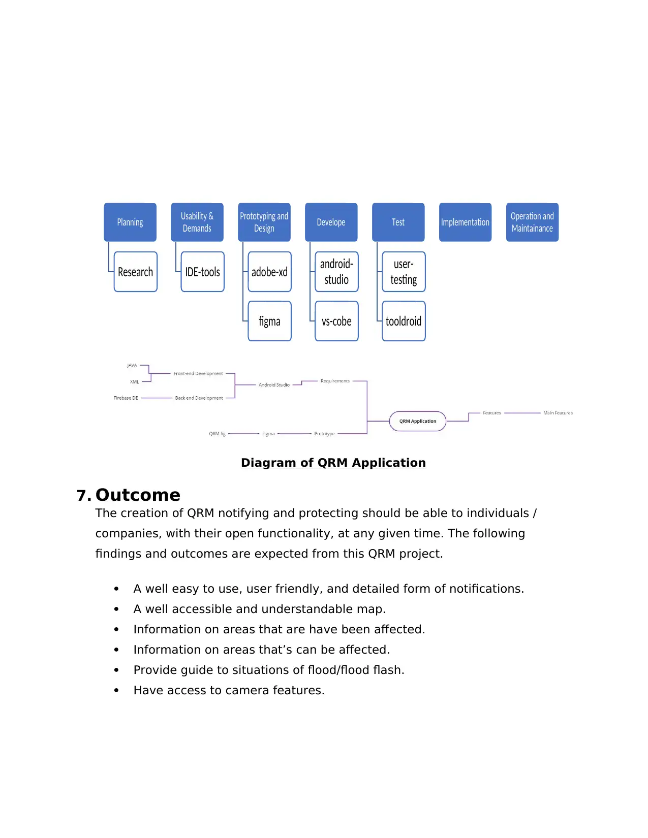
Diagram of QRM Application
7. Outcome
The creation of QRM notifying and protecting should be able to individuals /
companies, with their open functionality, at any given time. The following
findings and outcomes are expected from this QRM project.
A well easy to use, user friendly, and detailed form of notifications.
A well accessible and understandable map.
Information on areas that are have been affected.
Information on areas that’s can be affected.
Provide guide to situations of flood/flood flash.
Have access to camera features.
Planning
Research
Usability &
Demands
IDE-tools
Prototyping and
Design
adobe-xd
figma
Develope
android-
studio
vs-cobe
Test
user-
testing
tooldroid
Implementation Operation and
Maintainance
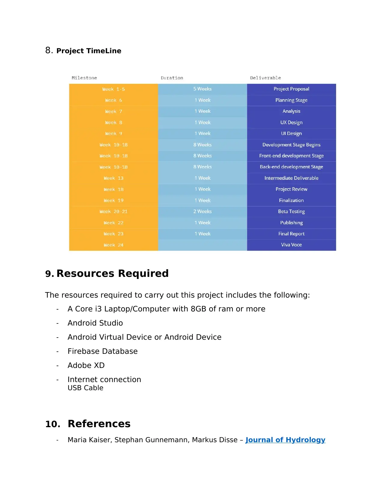
8. Project TimeLine
9. Resources Required
The resources required to carry out this project includes the following:
- A Core i3 Laptop/Computer with 8GB of ram or more
- Android Studio
- Android Virtual Device or Android Device
- Firebase Database
- Adobe XD
- Internet connection
USB Cable
10. References
- Maria Kaiser, Stephan Gunnemann, Markus Disse – Journal of Hydrology
⊘ This is a preview!⊘
Do you want full access?
Subscribe today to unlock all pages.
Trusted by 1+ million students worldwide

- Zaheer Allama , David S Jonesb - A conceptual framework for Port Louis, Mauritius;
1 out of 10
Your All-in-One AI-Powered Toolkit for Academic Success.
+13062052269
info@desklib.com
Available 24*7 on WhatsApp / Email
![[object Object]](/_next/static/media/star-bottom.7253800d.svg)
Unlock your academic potential
Copyright © 2020–2026 A2Z Services. All Rights Reserved. Developed and managed by ZUCOL.