Geological Features: Plate Boundaries, Earthquakes, and Their Impact
VerifiedAdded on 2022/08/20
|8
|1488
|12
Report
AI Summary
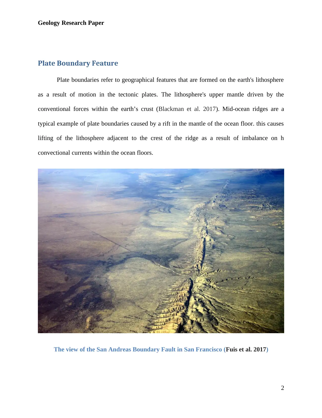
This report delves into the fascinating world of plate boundaries and their impact on the Earth's geology, with a specific focus on the San Andreas Fault and the Chilean Earthquake. The paper discusses the formation of plate boundaries, using the San Andreas Fault as a prime example, detailing its formation, geological activity (including earthquakes), and its significance as a tourist attraction. It then transitions to the study of earthquakes, exploring their causes, the devastating effects, and the scales used to measure their intensity, with the 1960 Valdivia earthquake in Chile as a case study. The report concludes by emphasizing the correlation between geological distribution and geographical features, highlighting the importance of understanding these phenomena for both environmental awareness and disaster preparedness. This research paper provides a comprehensive overview of these critical geological events and their broader implications.

Geographical Tour
Geology Research Paper
Institution Affiliation
Name of Student
Unit Title
Due Date
Geology Research Paper
Institution Affiliation
Name of Student
Unit Title
Due Date
Paraphrase This Document
Need a fresh take? Get an instant paraphrase of this document with our AI Paraphraser

Geology Research Paper
Plate Boundary Feature
Plate boundaries refer to geographical features that are formed on the earth's lithosphere
as a result of motion in the tectonic plates. The lithosphere's upper mantle driven by the
conventional forces within the earth’s crust (Blackman et al. 2017). Mid-ocean ridges are a
typical example of plate boundaries caused by a rift in the mantle of the ocean floor. this causes
lifting of the lithosphere adjacent to the crest of the ridge as a result of imbalance on h
convectional currents within the ocean floors.
The view of the San Andreas Boundary Fault in San Francisco (Fuis et al. 2017)
2

Geology Research Paper
The tour to these plate boundary features led San Andreas Fault in Los Angeles formed
as a result of drift between the pacific plates of Hawaii and Los Angeles past the tectonic plates
of San Francisco. San Andrea’s boundary extends to aver 1,200 kilometers through to California,
forming the boundary between the North American plates and the Pacific Ocean plates
(Verdecchia, & Carena, 2016). And the boundary runs through the epicenter of Santa Cruz
Mountains to Peninsula of San Francisco
San Andrea’s boundary was formed as a result of plate tectonic drift in North American
plates in southward motion developing a fault in the on the eastern sides of San Francisco as a
result of compressional forces within the lithospheres tectonic plates. San Andrea’s boundary
plate is dated to have formed hundreds of years ago as the Fallon plates and the pacific plates
began to spread apart towards the subduction areas off the North American west coast.
Geological activity associated with the drifting of plate tectonics at San Andreas is
Earthquake. As seismologists’ report on the situation and geological condition of San Andreas
fault, suggests that the fault at Park field at California produces a magnitude of approximately
6.10 earthquake in every 23 years (Zhang et al. 2017). This was evident when it was predicted
that an earthquake would occur in 2004, and it did happen due to the predicted motions of the
tectonic plates caused by conventional forces within the earth's mantle.
San Andreas provides beautiful scenery as it extends across county f the United States
into the Pacific Ocean. With it formation resulted in the creation of other geographical features
along its boundaries, proving tourist attraction sites, raising revenue to the federal government,
and source of livelihood to locals.
3
⊘ This is a preview!⊘
Do you want full access?
Subscribe today to unlock all pages.

Trusted by 1+ million students worldwide

Geology Research Paper
Earthquake Feature
The Chilean Earthquake
Earthquakes are caused by frequent and constant vibration in the earth’s crust that
eventually results in the shaking of the earth's surface. The unique thing earthquake is that,
unlike other geological activities, they occur without warning; thus, whenever there are reports
of earthquake anywhere, it is always associated with catastrophic damages including, loss of life
and destruction of properties. Statistics show that at least 30,000, both major and minor
earthquakes occur around the world yearly (Blackman et al. 2017). Though humans do not easily
detect signs of earthquake occurrence. Though sensible to very high sensitive devices as
seismometers are used to predict which areas are more likely prone to earthquakes than others
after studying the geological distribution of paces and the plate tectonic forces associated with
these regions.
Earthquakes are caused due to the build p of stresses between plates as they glide past
one another within the earth's mantle.
4
Paraphrase This Document
Need a fresh take? Get an instant paraphrase of this document with our AI Paraphraser

Geology Research Paper
The Stretch of Valdivia Earthquake in Chile (Briggs, 2016)
In the history of the earthquake, the world largest ever experienced earthquake was in
Valdivia, Chile, in the year 1960 (Kronmüller et al. 2017). The Valdivia Earthquake, as it was
named, had a magnitude of approximately 9.6, as was reported by the United States geological
survey. Though in every occurrence of earthquakes, they are always associated with destruction,
but the Great Chilean Earthquake had the highest magnitude compared to any other earthquake
witnessed.
The Valdivia earthquake occurred as a result of ground movement and gliding of plate
tectonics beneath the Pacific Ocean offshores of Chile’s coastal regions. It was estimated that the
Great Chilean earthquake destroyed hundreds of thousands of properties, leaving over two
million people homeless. The only arm that alerted people was that it occurred at around
midday, and the foreshock scared many to the point that they left houses in a bid to seek safety
5

Geology Research Paper
before the occurrence of the earthquake (Kronmüller et al. 2017).. Their subsidence of this
Valdivia Earthquake was approximately six feet along coastal regions of Chile, from Peninsula
to Chiloe Island.
The magnitude of damage was enormous as thousands of lives were lost, properties worth
millions of US dollars were destroyed, and over two million people were left homeless after the
occurrence of the earthquake (Blackman et al. 2017). Only structures that had reinforced
concrete remained standing though were the shaking weaken their pillars thus could not be used
again due to safety factors.
There are two methods or scales that are mostly used to measure earthquakes. That is the
Mercalli scale and the Richter scale. The Mercalli scale is used to measure the magnitude of
earthquakes ranging from 1 to 12 (Verdecchia, & Carena, 2016). High the scale reading
translates to more catastrophic the effects of the earthquake. The Richter scale is different from
Mercalli in that it is used to measure the energy associated with the earthquake, and the scale is
in logarithmic.
Conclusion
The geological distribution of the earth's crust affects the distribution of geographical
features since most of these features are formed as a result of rapid motions of the tectonic plates
and tectonic forces within the earth's lithosphere. As some of these features provides beautiful
scenery on the landscape, for example, mountains, lakes, etc. others cause damage and even loss
of lives upon their occurrence i.e., the occurrence of an earthquake.
6
⊘ This is a preview!⊘
Do you want full access?
Subscribe today to unlock all pages.

Trusted by 1+ million students worldwide

Geology Research Paper
San Andrea’s boundary fault covers a wide range of distance as it transverse across
counties with the United States and covers approximately 1200 kilometers. It is a source of
income revenue to the states as it is a tourist attraction feature, and to those living along, it is a
source of livelihood. The Valdivia earthquake was one of the largest ever witnessed an
earthquake in the word history that cause a lot of damages to properties, leaving over 2.000.000
people homeless
7
Paraphrase This Document
Need a fresh take? Get an instant paraphrase of this document with our AI Paraphraser

Geology Research Paper
Reference
Blackman, D. K., Boyce, D. E., Castelnau, O., Dawson, P. R., & Laske, G. (2017).
Effects of crystal preferred orientation on upper-mantle flow near plate boundaries: rheologic
feedbacks and seismic anisotropy. Geophysical Journal International, 210(3), 1481-1493.
Briggs, R. (2016). Earthquakes: Megathrusts and mountain building. Nature
Geoscience, 9(5), 346-348.
Fuis, G. S., Bauer, K., Goldman, M. R., Ryberg, T., Langenheim, V. E., Scheirer, D.
S., ... & Graves, R. W. (2017). Subsurface geometry of the San Andreas fault in southern
California: Results from the Salton Seismic Imaging Project (SSIP) and strong ground motion
expectations. Bulletin of the Seismological Society of America, 107(4), 1642-1662.
Kronmüller, E., Atallah, D. G., Gutiérrez, I., Guerrero, P., & Gedda, M. (2017).
Exploring indigenous perspectives of an environmental disaster: Culture and place as interrelated
resources for remembrance of the 1960 mega-earthquake in Chile. International journal of
disaster risk reduction, 23, 238-247.
Verdecchia, A., & Carena, S. (2016). Coulomb stress evolution in a diffuse plate
boundary: 1400 years of earthquakes in eastern California and western Nevada,
USA. Tectonics, 35(8), 1793-1811.
Zhang, T., Gordon, R. G., Mishra, J. K., & Wang, C. (2017). The Malpelo plate
hypothesis and implications for nonclosure of the Cocos‐Nazca‐Pacific plate motion
circuit. Geophysical Research Letters, 44(16), 8213-8218.
8
1 out of 8
Related Documents
Your All-in-One AI-Powered Toolkit for Academic Success.
+13062052269
info@desklib.com
Available 24*7 on WhatsApp / Email
Unlock your academic potential
Copyright © 2020–2026 A2Z Services. All Rights Reserved. Developed and managed by ZUCOL.


