Geological Survey Report: Analysis of Three Drilled Holes in LNG Site
VerifiedAdded on 2022/10/12
|11
|2491
|106
Report
AI Summary
This report presents a geological survey of three drilled holes, focusing on the analysis of rock formations, excavation procedures, and construction materials within an LNG facility project. The report begins with an introduction to the project's objectives and scope, followed by a detailed examination of various rock types found in the drilled holes, including Uluru Rock, Kata Tjuta, and others, along with their characteristics and locations. The excavation processes and risk management strategies are discussed, adhering to relevant codes of practice. The report also explores guidelines for excavation support, including earth retention and bracing support types. The core of the report provides the specifications of the drilled holes, lithographic codes, and rock strength data. It then delves into the analysis of potential bearing capacity failures, excavatability, and construction materials. The report concludes with a review of the data points for rock types and construction materials along with their conditions, supported by references to relevant literature and data sources, and excavatability charts. The assignment aims to assess ground conditions, foundation and slope stability, excavatability, and potential for construction material, providing a comprehensive understanding of the site's geological characteristics.
GEOLOGICAL SURVEY OF THREE DRILLED HOLES
INTRODUCTION
In this report file we will study about the structure of drilled holes, different types of rocks
found in the holes, understand the requirements of the project of investigation of the site,
types of load exerted on and sustained by the rocks, designing and construction issues of a
hole to be drilled.
TYPES OF ROCKS
There are different types of rocks found I the excavation process of drilling holes in Australia
are Uluru Rock; found in the northern territory also known as Ayers Rock these are huge
sandstone rocks and covers around 3.3 square kilometres, and also 9.4 kilometres around its
base with a height rises about 345 metres above the plain fields, The Kata Tjuta; this rock is
also found in the northern territories and is rounded with the 28 domes with Mt. Olga as the
highest peak around 546 metres above the plain fields, Karlwe Karlwe rock also known as
Devil’s Marbles is also found in northern territory near Wauchope and are often termed as
sacred stones by Aboringinal Dreaming and are said to be the fossilised eggs of the serpent of
rainbow, Mount Augustus also named as Burringurah is double the size of Uluru; a combined
structure of sandstone and conglomerate was formed due to the uplift of an ancient seabed
around 1000 million years old settled on the bed of granite rock around 1650 million years
old, Wave Rock is also very old about 2700 million years was formed by the dissolving and
re-deposition of chemicals in the granite is shaped as a curved cliff faced structure around 15
metres high and 110 metres long, Bald Rock is an isolated rock hill; the largest exposed
granite surface was emplaced by the uplift and erosion that removed the surrounded
sediments and the surrounded metamorphic rocks and due to the resistance from the weather
changes, and many more types of rocks (Ga.gov.au, 2019).
EXCAVATION AND ITS PROCEDURE
The excavation is a work which involves the removal of soil or rocks from a site to form an
open face, a hole or cavity using tools, machinery or explosives. The excavation process is
carried out by following the code of practice for excavation at the working site in spite of the
depth of the hole. The excavation processes to be carried out connected to a construction is
Paraphrase This Document
Need a fresh take? Get an instant paraphrase of this document with our AI Paraphraser
termed as high risk construction work if it is done in or near a shaft or trench with depth more
than 1.5 metres or a tunnel. These specific duties do not apply on a mine or bore where water
law is applied. The excavation procedure has some general requirements as; drilling,
trenching, levelling, digging, driving of pegs into the ground, etc. (Day, 2017). It is to be
understood that no excavation or penetration process should undergo at places adjacent to any
structural unit that could affect the structural integrity of the building. Before starting
excavation process the sites should be inspected thoroughly for stability and signs of collapse
on daily basis and after every blast operation, after an unexpected fall of support, after heavy
rainfall, after the usage of vibrating machines being used in close proximity.
RISK MANAGEMENT
According to the regulation 34-38 made by Excavation Works Department in the code of
practice in Australia can be stated as (Excavation Work code of practice, 2015):
To identify reasonable hazards that can be foreseen and could give the rise to the risks
in excavation.
To determine and eliminate the risks which is practically reasonable.
To maintain and implement control measures to counter control measures.
The code of practice explains the guidelines for managing risks by identifying risks,
accessing the risks, implementing measures for controlling and maintaining the effect of
control methodologies.
For controlling risks, level of safety gained from the control measures should be known by
the inspection and analysis of the measures that could be ranked according to highest safety
to lowest safety always aiming to eliminate a hazard. If the risks are not completely
eliminated then following steps should be taken (Excavation Work code of practice, 2015):
1) By substituting - use of excavator than manual methods to break rocks.
2) By Isolating - make concrete barriers to separate pedestrians and powered mobile
plant to eliminate risk of collision.
3) By introducing Engineering Controls – use of advanced methods like benching,
battering or shoring the sides of the excavation to eliminate the possibilities of failure
of ground or boundaries of the excavated site.
GUIDELINES FOR EXCAVATION SUPPORT
The functions to provide support to the excavation field to support and retain earth and
adjacent structures from falling are illustrated as:
a. The Earth Retention type (contains support wall like sheet pile, diaphragm wall, etc.).
b. Bracing Support type (either internal or external bracing like rakers, struts) that
supports the earth retention type.
The types of support required in excavation are (Zumrawi and El-Amin, 2016):
i. Diaphragm Wall is a continuous support wall made of concrete that is excavated in
place in accordance with the loads from retained soil and water. These walls are
designed on the basis of bending moments and shears resulting from lateral pressures
acting on the wall. These loads should be considered while designing the wall to
support vertical loads.
ii. Sheet Piling; a vertical steel shapes driven into the ground interconnected with each
other to support lateral loads, to form a continuous wall. The wall gets structural
strength from the sheets itself.
iii. Slurry Wall; a substantiated and continuous wall formed by filling a series of discrete
trenches with tremic concrete. The slurry is used to prevent collapsing of trench
during excavation for slurry wall preparation, this wall retain soil and groundwater at
the exterior wall and allows the excavation and removal of soil from inside.
iv. Preloaded Bracing; creates a tight fit between the supporting elements by reducing
shoring deflection and ground settlement during excavation, where feasible struts
should be applied in preload condition at 50% design loads to gain proper bearing
between supporting material.
LNG Site
The project site is a huge LNG facility (Woodside, 2019) whose data for three drilled holes
are provided. Australia is on the verge to cross LNG export capacity, Qatar was at the first
position. Now Australia is going to be the world’s largest liquefied natural gas (LNG)
exporter outshining Qatar, according to the data provided by Australia’s Department of
industry, innovation and science (DIIS).
⊘ This is a preview!⊘
Do you want full access?
Subscribe today to unlock all pages.
Trusted by 1+ million students worldwide
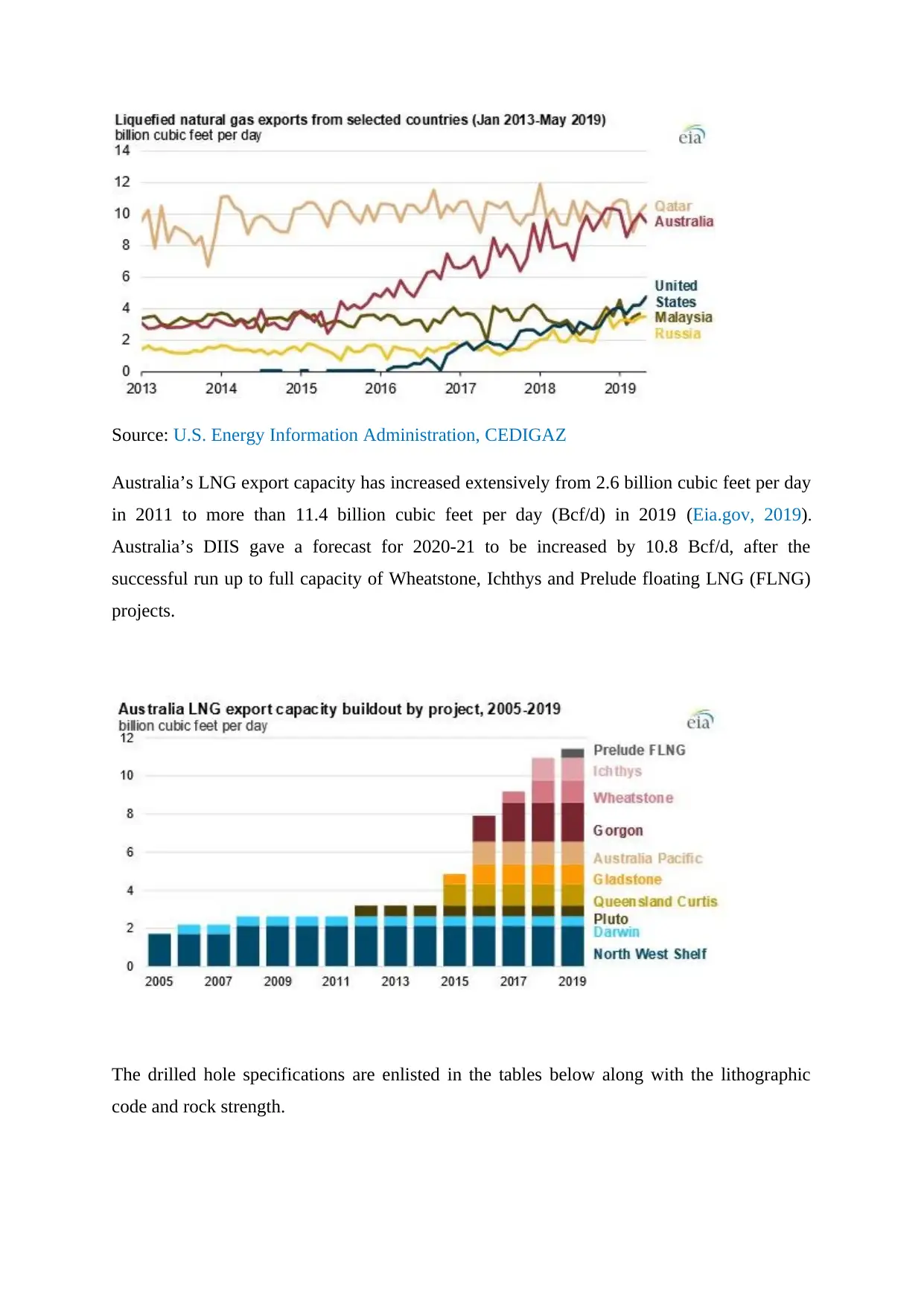
Source: U.S. Energy Information Administration, CEDIGAZ
Australia’s LNG export capacity has increased extensively from 2.6 billion cubic feet per day
in 2011 to more than 11.4 billion cubic feet per day (Bcf/d) in 2019 (Eia.gov, 2019).
Australia’s DIIS gave a forecast for 2020-21 to be increased by 10.8 Bcf/d, after the
successful run up to full capacity of Wheatstone, Ichthys and Prelude floating LNG (FLNG)
projects.
The drilled hole specifications are enlisted in the tables below along with the lithographic
code and rock strength.
Paraphrase This Document
Need a fresh take? Get an instant paraphrase of this document with our AI Paraphraser
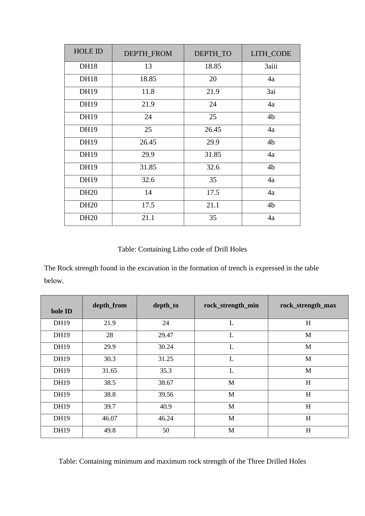
HOLE ID DEPTH_FROM DEPTH_TO LITH_CODE
DH18 13 18.85 3aiii
DH18 18.85 20 4a
DH19 11.8 21.9 3ai
DH19 21.9 24 4a
DH19 24 25 4b
DH19 25 26.45 4a
DH19 26.45 29.9 4b
DH19 29.9 31.85 4a
DH19 31.85 32.6 4b
DH19 32.6 35 4a
DH20 14 17.5 4a
DH20 17.5 21.1 4b
DH20 21.1 35 4a
Table: Containing Litho code of Drill Holes
The Rock strength found in the excavation in the formation of trench is expressed in the table
below.
hole ID depth_from depth_to rock_strength_min rock_strength_max
DH19 21.9 24 L H
DH19 28 29.47 L M
DH19 29.9 30.24 L M
DH19 30.3 31.25 L M
DH19 31.65 35.3 L M
DH19 38.5 38.67 M H
DH19 38.8 39.56 M H
DH19 39.7 40.9 M H
DH19 46.07 46.24 M H
DH19 49.8 50 M H
Table: Containing minimum and maximum rock strength of the Three Drilled Holes
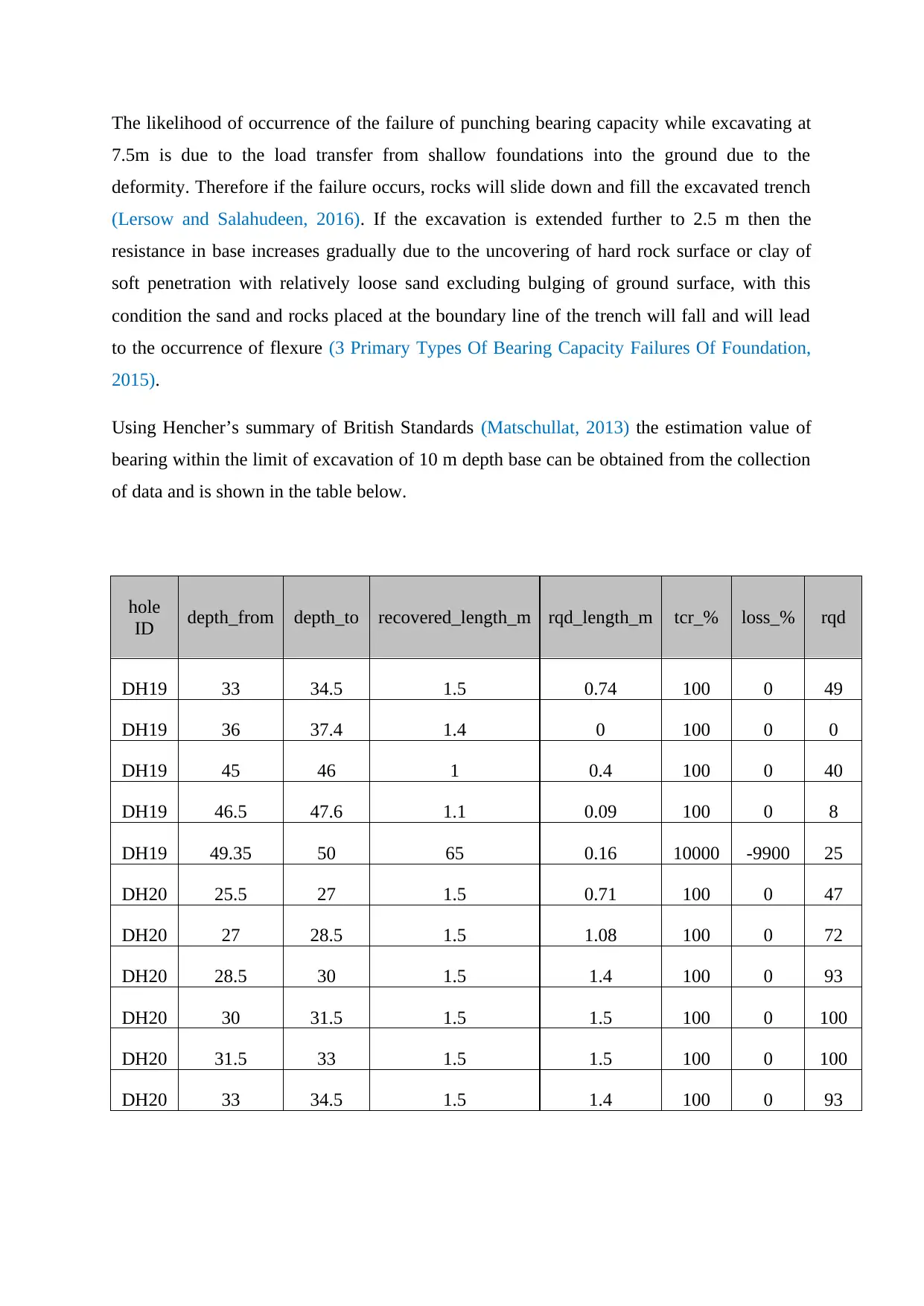
The likelihood of occurrence of the failure of punching bearing capacity while excavating at
7.5m is due to the load transfer from shallow foundations into the ground due to the
deformity. Therefore if the failure occurs, rocks will slide down and fill the excavated trench
(Lersow and Salahudeen, 2016). If the excavation is extended further to 2.5 m then the
resistance in base increases gradually due to the uncovering of hard rock surface or clay of
soft penetration with relatively loose sand excluding bulging of ground surface, with this
condition the sand and rocks placed at the boundary line of the trench will fall and will lead
to the occurrence of flexure (3 Primary Types Of Bearing Capacity Failures Of Foundation,
2015).
Using Hencher’s summary of British Standards (Matschullat, 2013) the estimation value of
bearing within the limit of excavation of 10 m depth base can be obtained from the collection
of data and is shown in the table below.
hole
ID depth_from depth_to recovered_length_m rqd_length_m tcr_% loss_% rqd
DH19 33 34.5 1.5 0.74 100 0 49
DH19 36 37.4 1.4 0 100 0 0
DH19 45 46 1 0.4 100 0 40
DH19 46.5 47.6 1.1 0.09 100 0 8
DH19 49.35 50 65 0.16 10000 -9900 25
DH20 25.5 27 1.5 0.71 100 0 47
DH20 27 28.5 1.5 1.08 100 0 72
DH20 28.5 30 1.5 1.4 100 0 93
DH20 30 31.5 1.5 1.5 100 0 100
DH20 31.5 33 1.5 1.5 100 0 100
DH20 33 34.5 1.5 1.4 100 0 93
⊘ This is a preview!⊘
Do you want full access?
Subscribe today to unlock all pages.
Trusted by 1+ million students worldwide
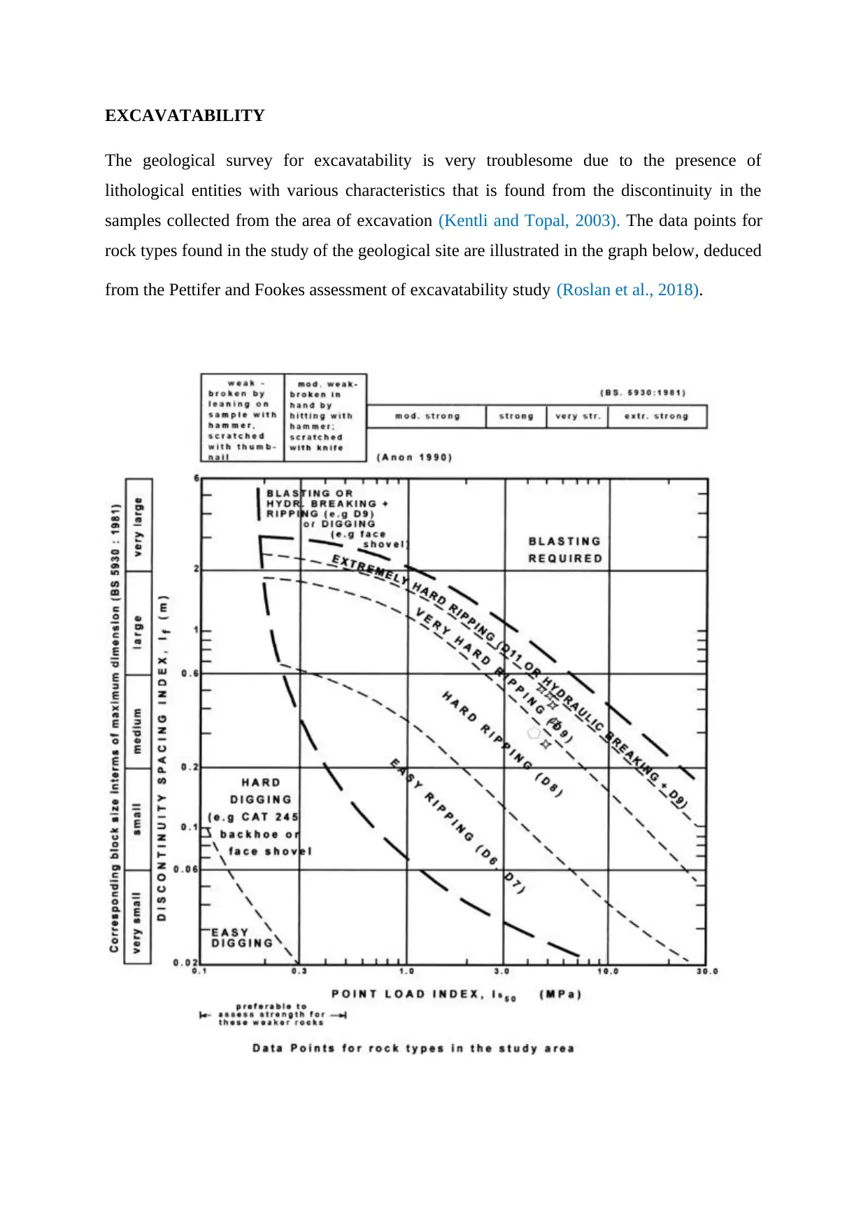
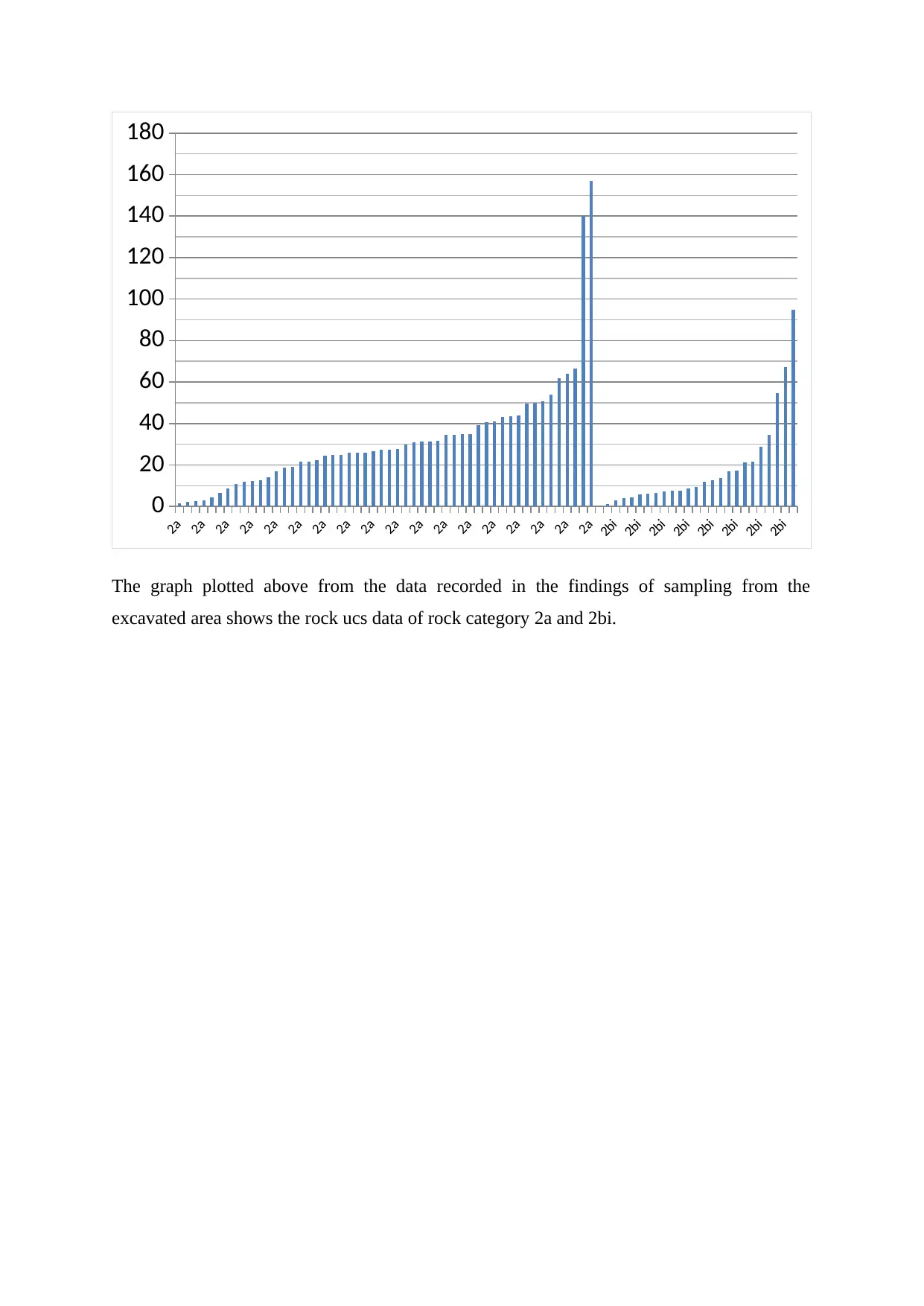
EXCAVATABILITY
The geological survey for excavatability is very troublesome due to the presence of
lithological entities with various characteristics that is found from the discontinuity in the
samples collected from the area of excavation (Kentli and Topal, 2003). The data points for
rock types found in the study of the geological site are illustrated in the graph below, deduced
from the Pettifer and Fookes assessment of excavatability study (Roslan et al., 2018).
Paraphrase This Document
Need a fresh take? Get an instant paraphrase of this document with our AI Paraphraser
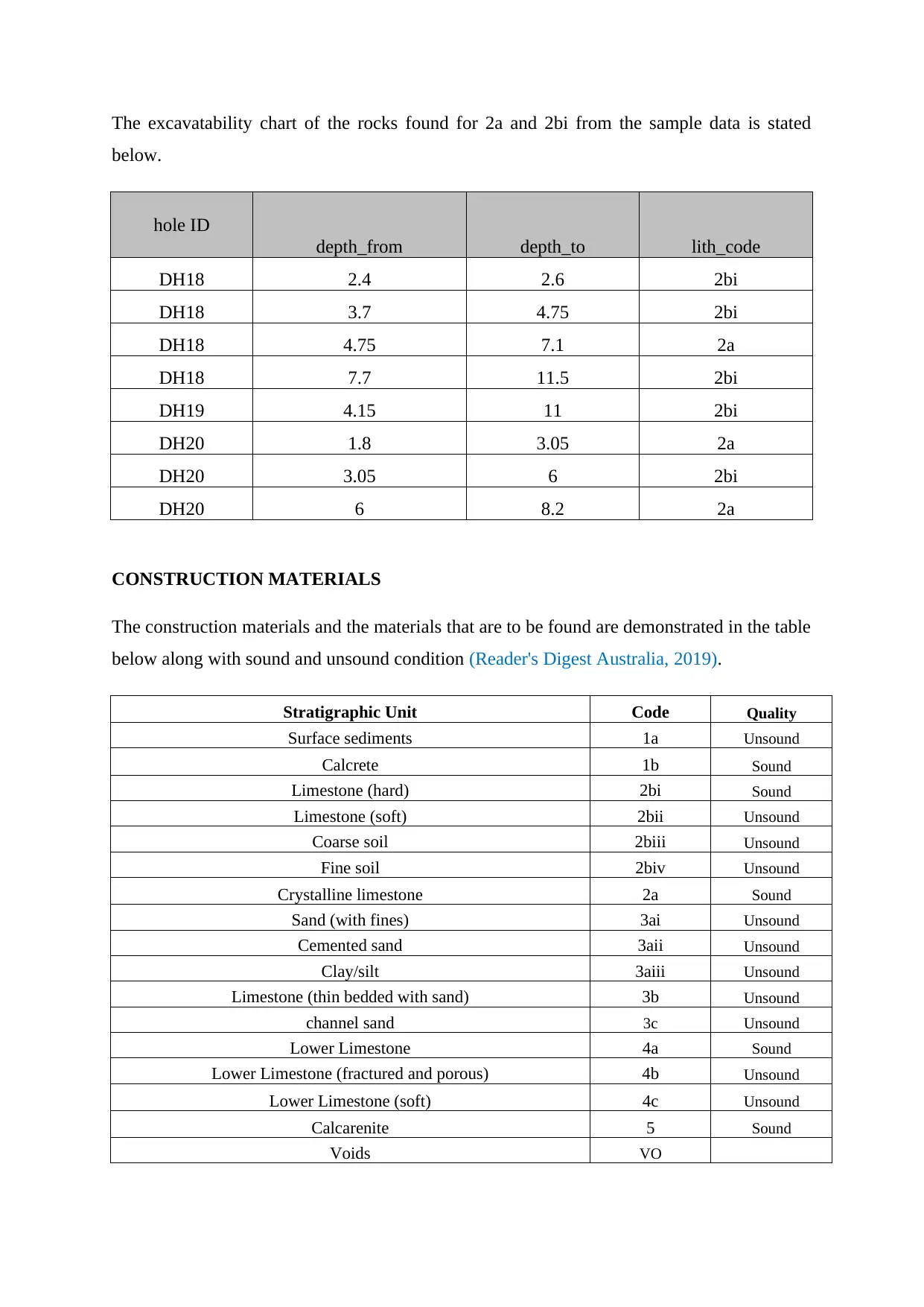
The excavatability chart of the rocks found for 2a and 2bi from the sample data is stated
below.
hole ID
depth_from depth_to lith_code
DH18 2.4 2.6 2bi
DH18 3.7 4.75 2bi
DH18 4.75 7.1 2a
DH18 7.7 11.5 2bi
DH19 4.15 11 2bi
DH20 1.8 3.05 2a
DH20 3.05 6 2bi
DH20 6 8.2 2a
CONSTRUCTION MATERIALS
The construction materials and the materials that are to be found are demonstrated in the table
below along with sound and unsound condition (Reader's Digest Australia, 2019).
Stratigraphic Unit Code Quality
Surface sediments 1a Unsound
Calcrete 1b Sound
Limestone (hard) 2bi Sound
Limestone (soft) 2bii Unsound
Coarse soil 2biii Unsound
Fine soil 2biv Unsound
Crystalline limestone 2a Sound
Sand (with fines) 3ai Unsound
Cemented sand 3aii Unsound
Clay/silt 3aiii Unsound
Limestone (thin bedded with sand) 3b Unsound
channel sand 3c Unsound
Lower Limestone 4a Sound
Lower Limestone (fractured and porous) 4b Unsound
Lower Limestone (soft) 4c Unsound
Calcarenite 5 Sound
Voids VO
2a
2a
2a
2a
2a
2a
2a
2a
2a
2a
2a
2a
2a
2a
2a
2a
2a
2a
2bi
2bi
2bi
2bi
2bi
2bi
2bi
2bi
0
20
40
60
80
100
120
140
160
180
The graph plotted above from the data recorded in the findings of sampling from the
excavated area shows the rock ucs data of rock category 2a and 2bi.
2a
2a
2a
2a
2a
2a
2a
2a
2a
2a
2a
2a
2a
2a
2a
2a
2a
2bi
2bi
2bi
2bi
2bi
2bi
2bi
2bi
0
20
40
60
80
100
120
140
160
180
The graph plotted above from the data recorded in the findings of sampling from the
excavated area shows the rock ucs data of rock category 2a and 2bi.
⊘ This is a preview!⊘
Do you want full access?
Subscribe today to unlock all pages.
Trusted by 1+ million students worldwide
REFERENCES
Ga.gov.au. (2019). Significant Rock Features | Geoscience Australia. [online] Available at:
http://www.ga.gov.au/scientific-topics/national-location-information/landforms/significant-
rock-features [Accessed 30 Sep. 2019].
Excavation Work code of practice. (2015). [pdf] Cannington: Government of Australia, pp.2-
4. Available at: https://www.safeworkaustralia.gov.au/system/files/documents/1705/mcop-
excavation-work-v3.pdf [Accessed 30 Sep. 2019].
Day, J. (2017). Excavation and Penetration ProcedureHealth & Safety. 3rd ed. [pdf] Roy
Hill, pp.2-4. Available at: https://www.royhill.com.au/wp-content/uploads/2018/07/OP-PRO-
00355_3.pdf [Accessed 30 Sep. 2019].
Zumrawi, M. and El-Amin, A. (2016). Importance of Deep Excavation Support and Its
Influence on Adjacent Buildings. Available online at www.ejournals.uofk.edu Proceedings
Vol. 1 pp. xxx 7th Annual Conference for Postgraduate Studies and Scientific Research Basic
Sciences, [online] 1, pp.4-5. Available at: http://www.ejournals.uofk.edu/ [Accessed 30 Sep.
2019].
Eia.gov. (2019). Today In Energy. [online] Available at:
https://www.eia.gov/todayinenergy/detail.php?id=40853 [Accessed 1 Oct. 2019].
Lersow, M. and Salahudeen, A. (2016). Why allowable bearing capacity for shallow
foundations but ultimate bearing capacity for deep foundations?. [online] Researchgate.
Available at:
https://www.researchgate.net/post/Why_allowable_bearing_capacity_for_shallow_foundatio
ns_but_ultimate_bearing_capacity_for_deep_foundations [Accessed 18 Oct. 2019].
3 PRIMARY TYPES OF BEARING CAPACITY FAILURES OF FOUNDATION. (2015).
[Blog] CivilBlog.Org. Available at: https://civilblog.org/2015/07/25/3-primary-types-of-
bearing-capacity-failures-of-foundation/ [Accessed 18 Oct. 2019].
Kentli, B. and Topal, T. (2003). Evaluation of rock excavatability and slope stability along a
segment of motorway, Pozanti, Turkey. Environmental Geology, [online] 1(1), pp.1-1.
Available at:
https://www.researchgate.net/publication/225174843_Evaluation_of_rock_excavatability_an
d_slope_stability_along_a_segment_of_motorway_Pozanti_Turkey [Accessed 18 Oct. 2019].
Paraphrase This Document
Need a fresh take? Get an instant paraphrase of this document with our AI Paraphraser
Reader's Digest Australia. (2019). Types of Building Materials | Reader's Digest Australia.
[online] Available at: https://www.readersdigest.com.au/diy-tips/types-of-building-materials
[Accessed 21 Oct. 2019].
Roslan, R., Omar, R., Baharuddin, I., Taha, H., Fared, M. and Hashim, W. (2018).
Determination of Segari Rock Slope Excavation Technique using Geological Strength Index
(GSI). International Journal of Engineering & Technology, [online] 7(4.35), p.819. Available
at:
https://www.researchgate.net/publication/225552483_Excavatability_assessment_of_rock_m
asses_using_the_Geological_Strength_Index_GSI.
Matschullat, J. (2013). Hencher S: Practical engineering geology. 71st ed. [ebook] Freiberg:
Technische Universität Bergakademie, pp.1-9. Available at:
https://www.researchgate.net/publication/271914451_Hencher_S_Practical_engineering_geol
ogy [Accessed 21 Oct. 2019].
Woodside. (2019). Pluto LNG - Woodside Energy. [online] Available at:
https://www.woodside.com.au/our-business/pluto-lng [Accessed 21 Oct. 2019].
1 out of 11

Your All-in-One AI-Powered Toolkit for Academic Success.
+13062052269
info@desklib.com
Available 24*7 on WhatsApp / Email
![[object Object]](/_next/static/media/star-bottom.7253800d.svg)
Unlock your academic potential
Copyright © 2020–2026 A2Z Services. All Rights Reserved. Developed and managed by ZUCOL.