GIS Site Selection: Environmental Management Project - Student Housing

Verified

Added on  2022/08/25

|14
|1428
|17
Practical Assignment
AI Summary
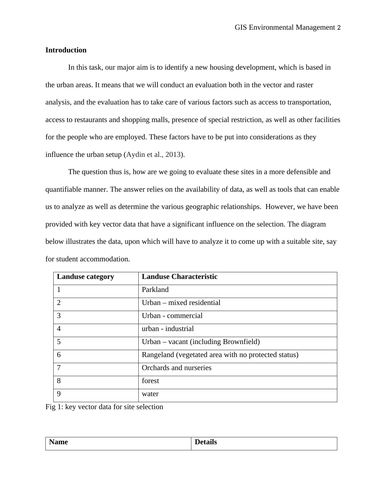
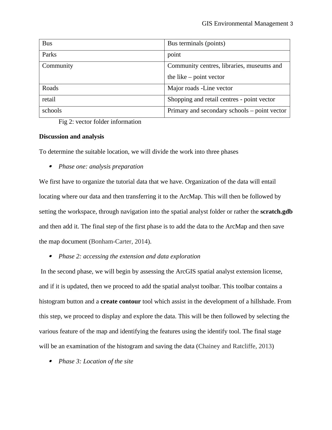
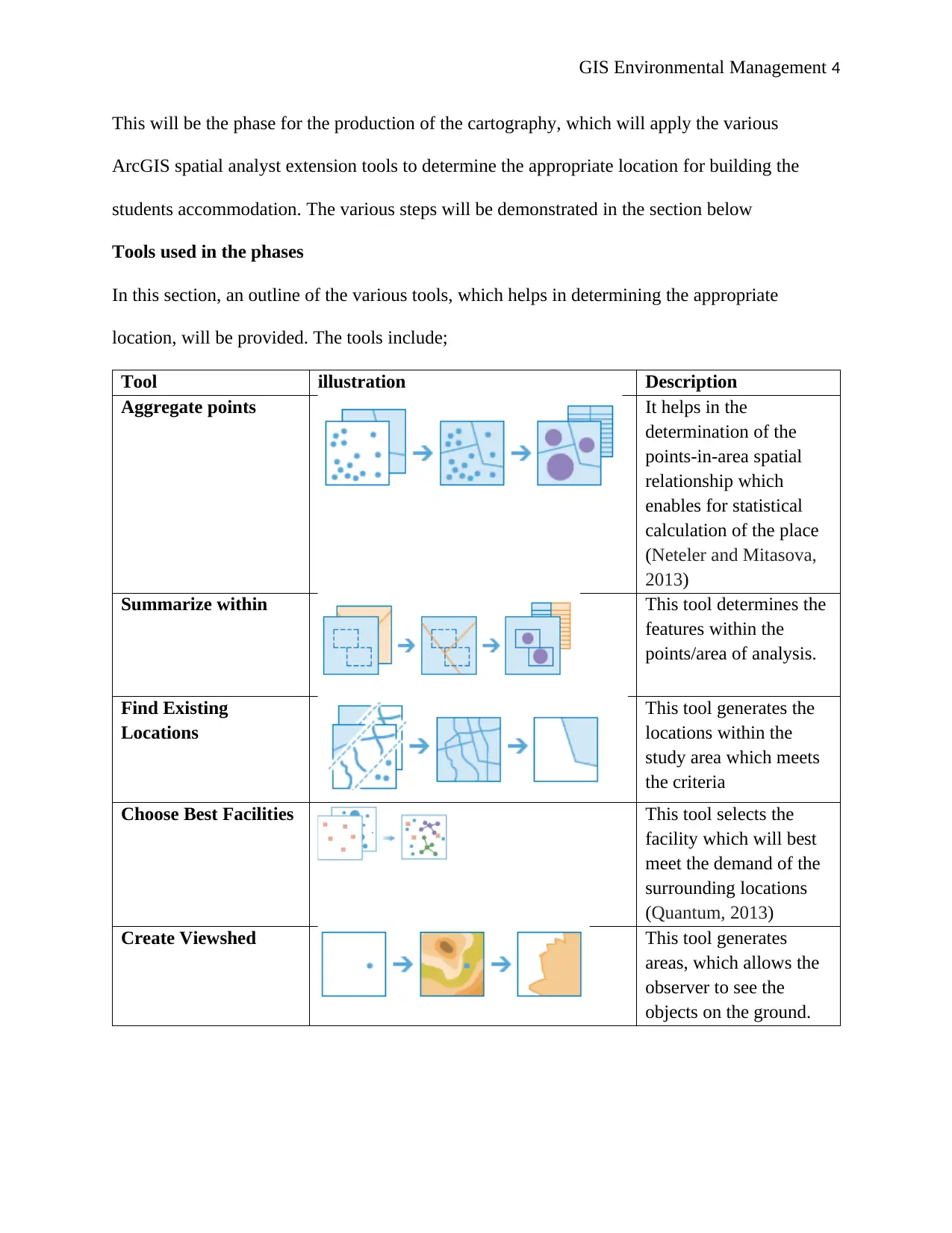
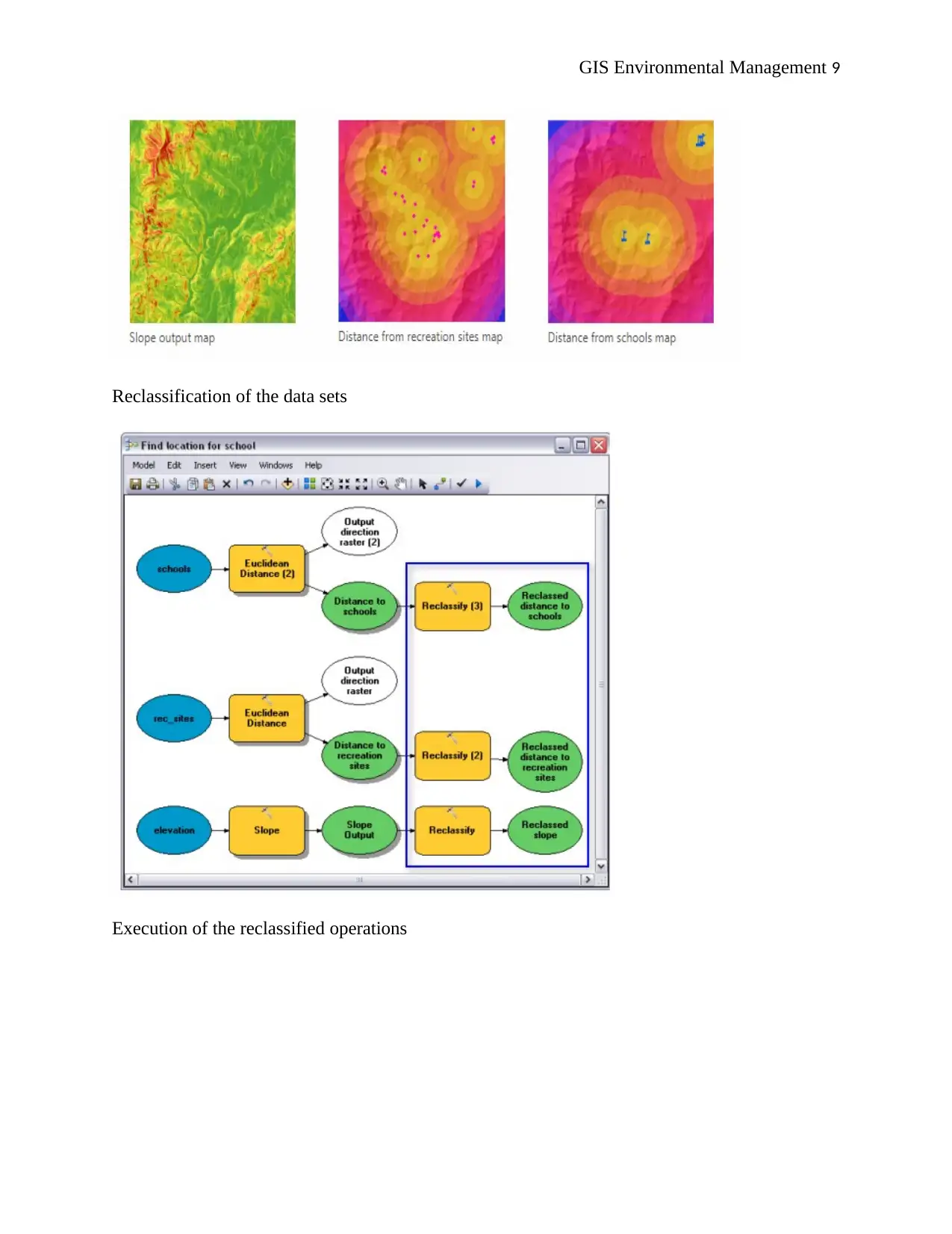
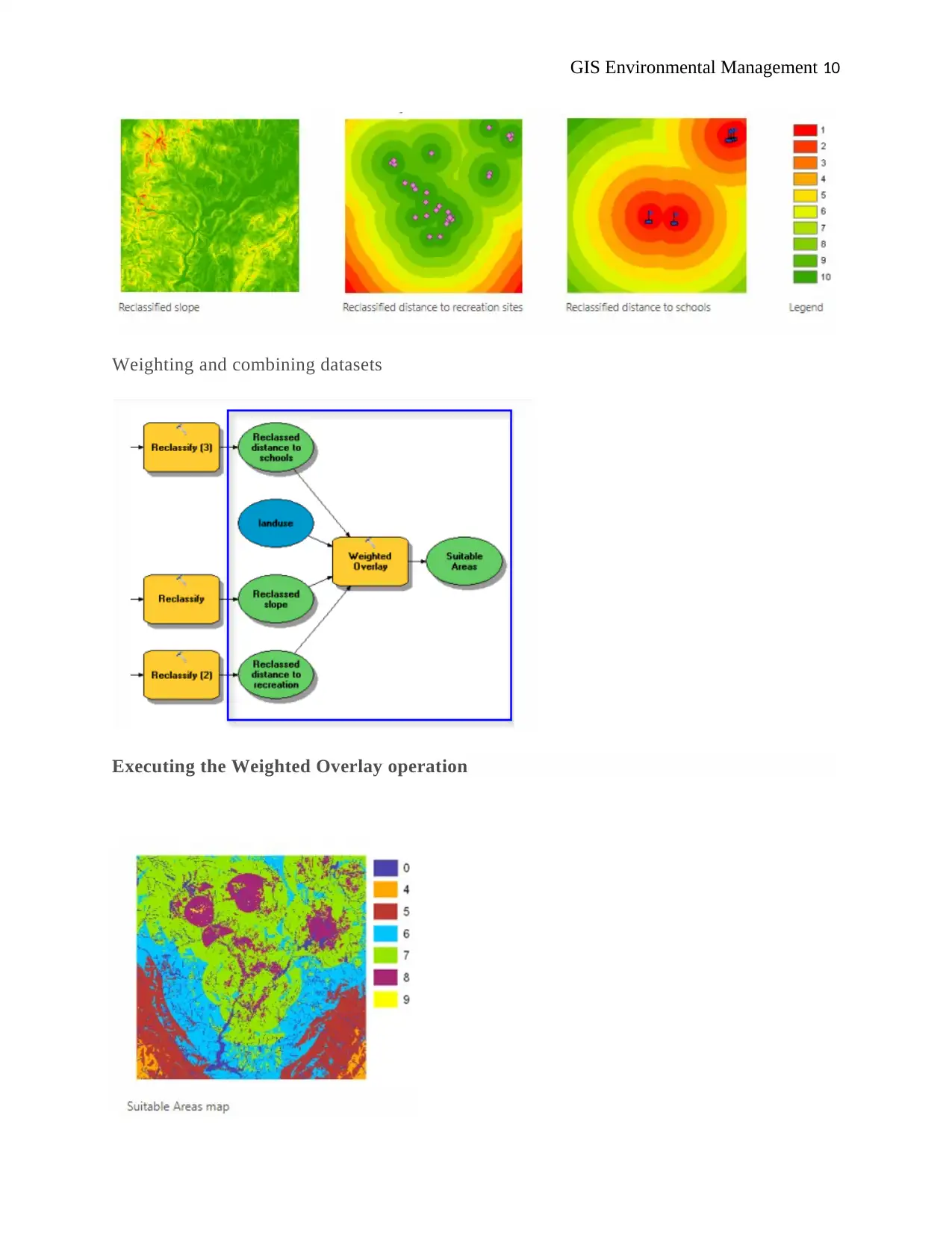
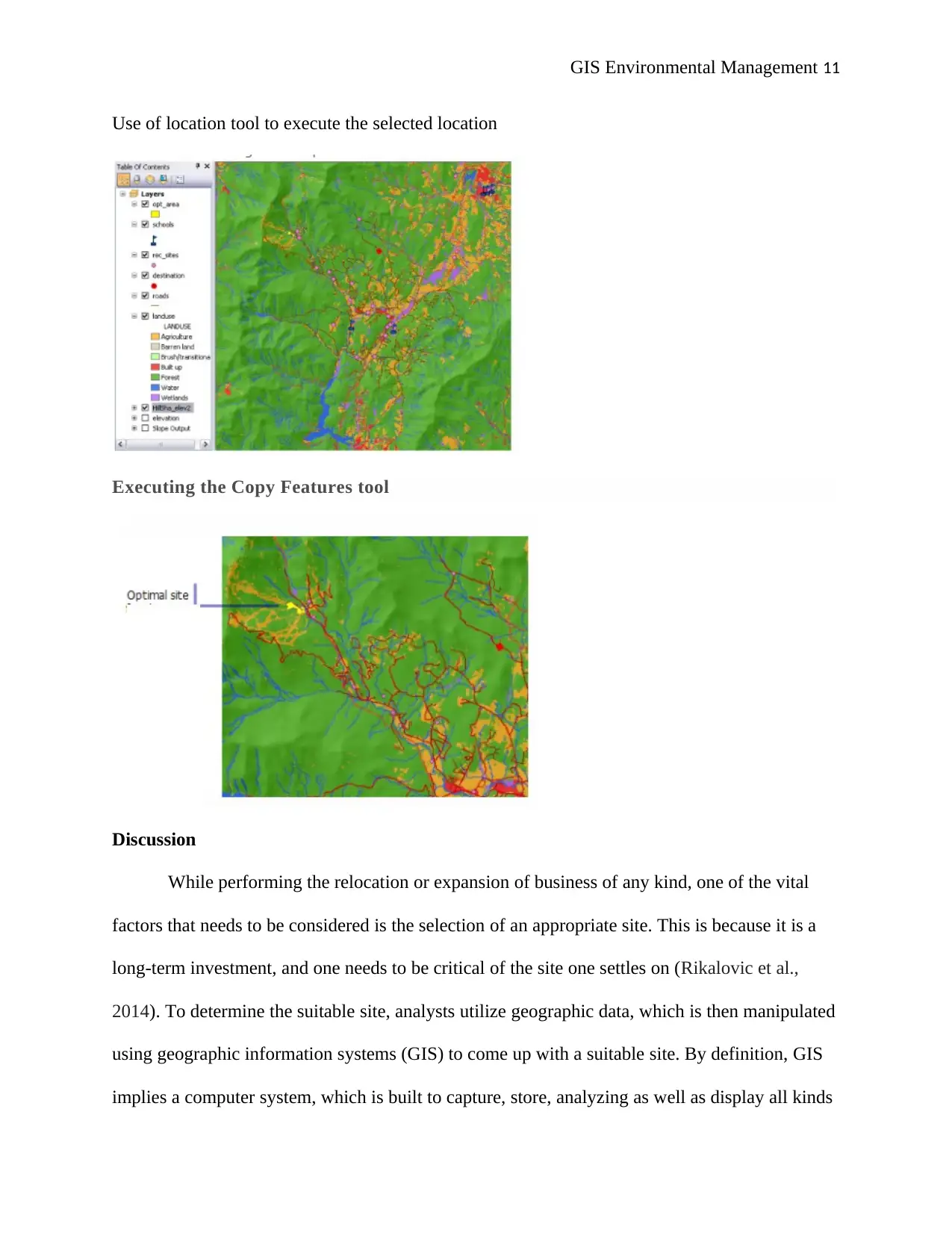
This assignment provides a comprehensive analysis of site selection using Geographic Information Systems (GIS) and ArcGIS. The project focuses on identifying a suitable location for a new housing development, specifically targeting student accommodation, within an urban environment. The methodology involves the evaluation of both vector and raster data, considering factors like access to transportation, shopping, restaurants, and the presence of special restrictions. The analysis is divided into three phases: preparation, data exploration, and site location. Various ArcGIS spatial analyst extension tools are employed, including Aggregate points, Summarize within, Find Existing Locations, Choose Best Facilities, and Create Viewshed, along with model builder techniques for data processing and cartographic representation. The discussion highlights the advantages and disadvantages of GIS, emphasizing its role in informed decision-making. The assignment concludes by demonstrating how GIS can be utilized in the determination of suitable sites for various activities, while also acknowledging the time and resources required for effective implementation.
Document Page
GIS Environmental Management 1
GIS ENVIRONMENTAL MANAGEMENT
Name of Student
Institution
Date
Location
tabler-icon-diamond-filled.svg

Secure Best Marks with AI Grader

Need help grading? Try our AI Grader for instant feedback on your assignments.
Document Page
GIS Environmental Management 2
Introduction
In this task, our major aim is to identify a new housing development, which is based in
the urban areas. It means that we will conduct an evaluation both in the vector and raster
analysis, and the evaluation has to take care of various factors such as access to transportation,
access to restaurants and shopping malls, presence of special restriction, as well as other facilities
for the people who are employed. These factors have to be put into considerations as they
influence the urban setup (Aydin et al., 2013).
The question thus is, how are we going to evaluate these sites in a more defensible and
quantifiable manner. The answer relies on the availability of data, as well as tools that can enable
us to analyze as well as determine the various geographic relationships. However, we have been
provided with key vector data that have a significant influence on the selection. The diagram
below illustrates the data, upon which will have to analyze it to come up with a suitable site, say
for student accommodation.
Landuse category Landuse Characteristic
1 Parkland
2 Urban – mixed residential
3 Urban - commercial
4 urban - industrial
5 Urban – vacant (including Brownfield)
6 Rangeland (vegetated area with no protected status)
7 Orchards and nurseries
8 forest
9 water
Fig 1: key vector data for site selection
Name Details
Document Page
GIS Environmental Management 3
Bus Bus terminals (points)
Parks point
Community Community centres, libraries, museums and
the like – point vector
Roads Major roads -Line vector
retail Shopping and retail centres - point vector
schools Primary and secondary schools – point vector
Fig 2: vector folder information
Discussion and analysis
To determine the suitable location, we will divide the work into three phasesď‚· Phase one: analysis preparation
We first have to organize the tutorial data that we have. Organization of the data will entail
locating where our data and then transferring it to the ArcMap. This will then be followed by
setting the workspace, through navigation into the spatial analyst folder or rather the scratch.gdb
and then add it. The final step of the first phase is to add the data to the ArcMap and then save
the map document (Bonham-Carter, 2014).ď‚· Phase 2: accessing the extension and data exploration
In the second phase, we will begin by assessing the ArcGIS spatial analyst extension license,
and if it is updated, then we proceed to add the spatial analyst toolbar. This toolbar contains a
histogram button and a create contour tool which assist in the development of a hillshade. From
this step, we proceed to display and explore the data. This will be then followed by selecting the
various feature of the map and identifying the features using the identify tool. The final stage
will be an examination of the histogram and saving the data (Chainey and Ratcliffe, 2013)ď‚· Phase 3: Location of the site
Document Page
GIS Environmental Management 4
This will be the phase for the production of the cartography, which will apply the various
ArcGIS spatial analyst extension tools to determine the appropriate location for building the
students accommodation. The various steps will be demonstrated in the section below
Tools used in the phases
In this section, an outline of the various tools, which helps in determining the appropriate
location, will be provided. The tools include;
Tool illustration Description
Aggregate points It helps in the
determination of the
points-in-area spatial
relationship which
enables for statistical
calculation of the place
(Neteler and Mitasova,
2013)
Summarize within This tool determines the
features within the
points/area of analysis.
Find Existing
Locations
This tool generates the
locations within the
study area which meets
the criteria
Choose Best Facilities This tool selects the
facility which will best
meet the demand of the
surrounding locations
(Quantum, 2013)
Create Viewshed This tool generates
areas, which allows the
observer to see the
objects on the ground.
tabler-icon-diamond-filled.svg

Secure Best Marks with AI Grader

Need help grading? Try our AI Grader for instant feedback on your assignments.
Document Page
GIS Environmental Management 5
A cartographic (model builder) diagram
Creation of a new model in the model builder
Renaming of the model
Specification of the various environmental settings
Document Page
GIS Environmental Management 6
Derivation of the datasets
Document Page
GIS Environmental Management 7
Derivation of the slope from elevation
tabler-icon-diamond-filled.svg

Paraphrase This Document

Need a fresh take? Get an instant paraphrase of this document with our AI Paraphraser
Document Page
GIS Environmental Management 8
Running the model to determine the data sets
Document Page
GIS Environmental Management 9
Reclassification of the data sets
Execution of the reclassified operations
Document Page
GIS Environmental Management 10
Weighting and combining datasets
Executing the Weighted Overlay operation
tabler-icon-diamond-filled.svg

Secure Best Marks with AI Grader

Need help grading? Try our AI Grader for instant feedback on your assignments.
Document Page
GIS Environmental Management 11
Use of location tool to execute the selected location
Executing the Copy Features tool
Discussion
While performing the relocation or expansion of business of any kind, one of the vital
factors that needs to be considered is the selection of an appropriate site. This is because it is a
long-term investment, and one needs to be critical of the site one settles on (Rikalovic et al.,
2014). To determine the suitable site, analysts utilize geographic data, which is then manipulated
using geographic information systems (GIS) to come up with a suitable site. By definition, GIS
implies a computer system, which is built to capture, store, analyzing as well as display all kinds
Document Page
GIS Environmental Management 12
of geographic and spatial data. This power fool tool is associated with some benefits as well as
drawbacks, as outlined below;
Advantages of GIS
I. GIS improves the organizational integration through the integration of both the hardware
and software data to manipulate all the geographic information needed
II. GIS allows for a comprehensive understanding of data in vast ways thus revealing
various trends, patterns and existing relationships in the form of reports, maps, and charts
III. GIS provides solutions to problems in a more simplified manner (Wheatley and Gillings,
2013)
IV. The technology can as well be incorporated into a framework for any kind of enterprise
information system
V. It also enhances the communication between departments and organizations, which are
involved through the various visual formats in which it is produced.
Drawbacks
I. On the other side, one major challenge with the GIS is that it is expensive
VI. It requires a great amount of data that must be fed in, hence tiresome and requires total
dedication Wheatley and Gillings, 2013).
II. With greater scales, the GIS is prone to generating geographic errors.
Conclusion
GIS plays a vital role in the determination of suitable sites for various activities. The tools
utilized, however, needs to be properly analyzed to obtain reliable information. In this
experiment, gis has been adopted and a suitable site determined for the construction of
accommodation for students. Further, it has been noted that gis is associated with numerous
Document Page
GIS Environmental Management 13
advantages, amongst them, being; improvement of the organizational integration, enabling a
comprehensive understanding of data etc. one major setback associated with the technology is
that it is expensive and requires a lot of dedication as it is time-consuming.
tabler-icon-diamond-filled.svg

Paraphrase This Document

Need a fresh take? Get an instant paraphrase of this document with our AI Paraphraser
Document Page
GIS Environmental Management 14
References
Aydin, N.Y., Kentel, E. and Duzgun, H.S., 2013. GIS-based site selection methodology for
hybrid renewable energy systems: A case study from western Turkey. Energy Conversion and
Management, 70, pp.90-106.
Bonham-Carter, G.F., 2014. Geographic information systems for geoscientists: modelling with
GIS (Vol. 13). Elsevier.
Chainey, S. and Ratcliffe, J., 2013. GIS and crime mapping. John Wiley & Sons.
Fotheringham, S. and Rogerson, P. eds., 2013. Spatial analysis and GIS. CRC Press.
Neteler, M. and Mitasova, H., 2013. Open source GIS: a GRASS GIS approach (Vol. 689).
Springer Science & Business Media.
Quantum, G.I.S., 2013. Development Team. (2013). Quantum GIS geographic information
system. Open Source Geospatial Foundation Project.
Rikalovic, A., Cosic, I. and Lazarevic, D., 2014. GIS-based multi-criteria analysis for industrial
site selection. Procedia Engineering, 69(12), pp.1054-1063.
Wheatley, D. and Gillings, M., 2013. Spatial technology and archaeology: the archaeological
applications of GIS. CRC Press.
chevron_up_icon
1 out of 14
circle_padding
hide_on_mobile
zoom_out_icon
logo.png

Your All-in-One AI-Powered Toolkit for Academic Success.

Available 24*7 on WhatsApp / Email

[object Object]