West-Muskoka Highway Realignment Design Project - CADM CV414-01

Verified

Added on  2022/08/20

|5
|525
|100
Report
AI Summary
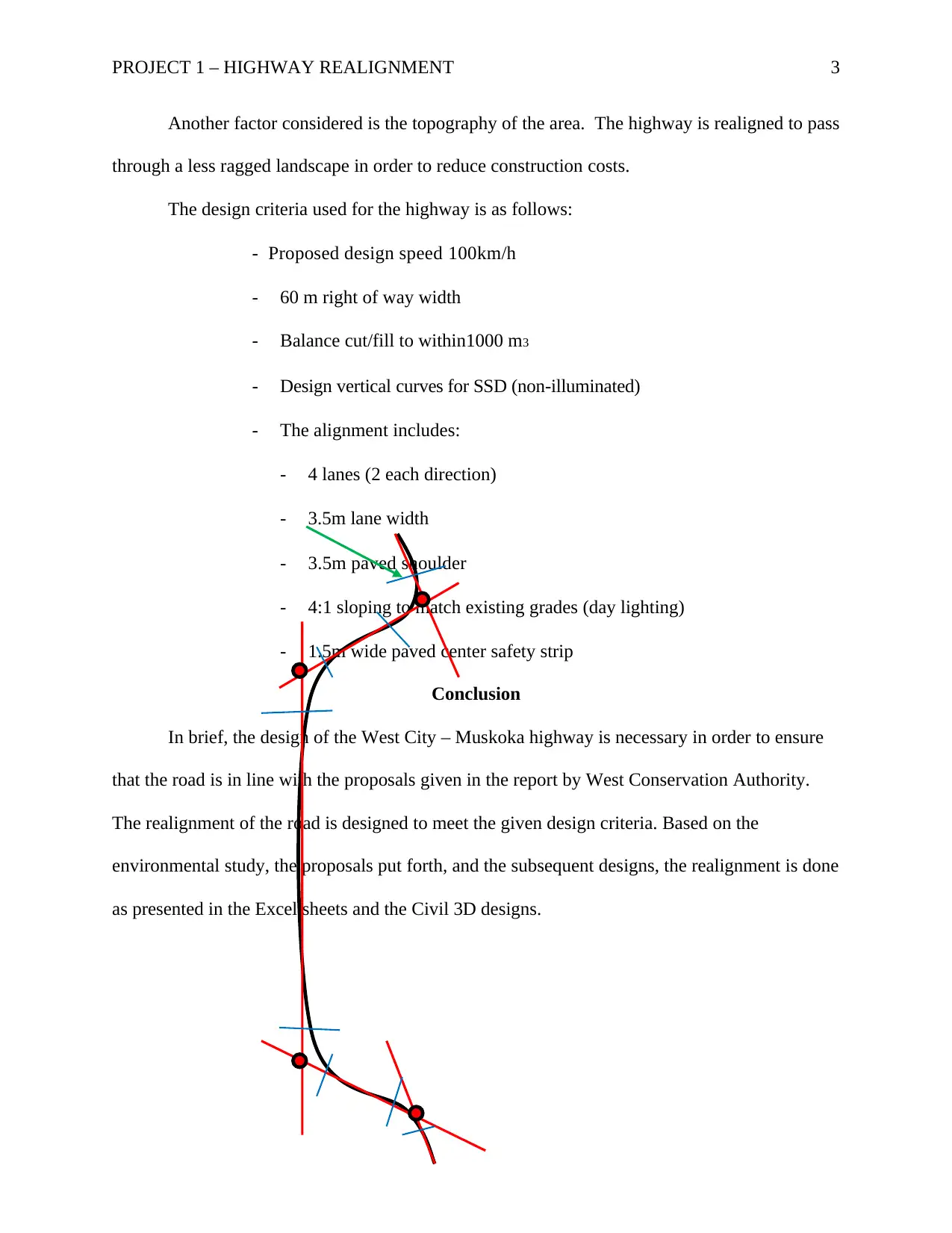
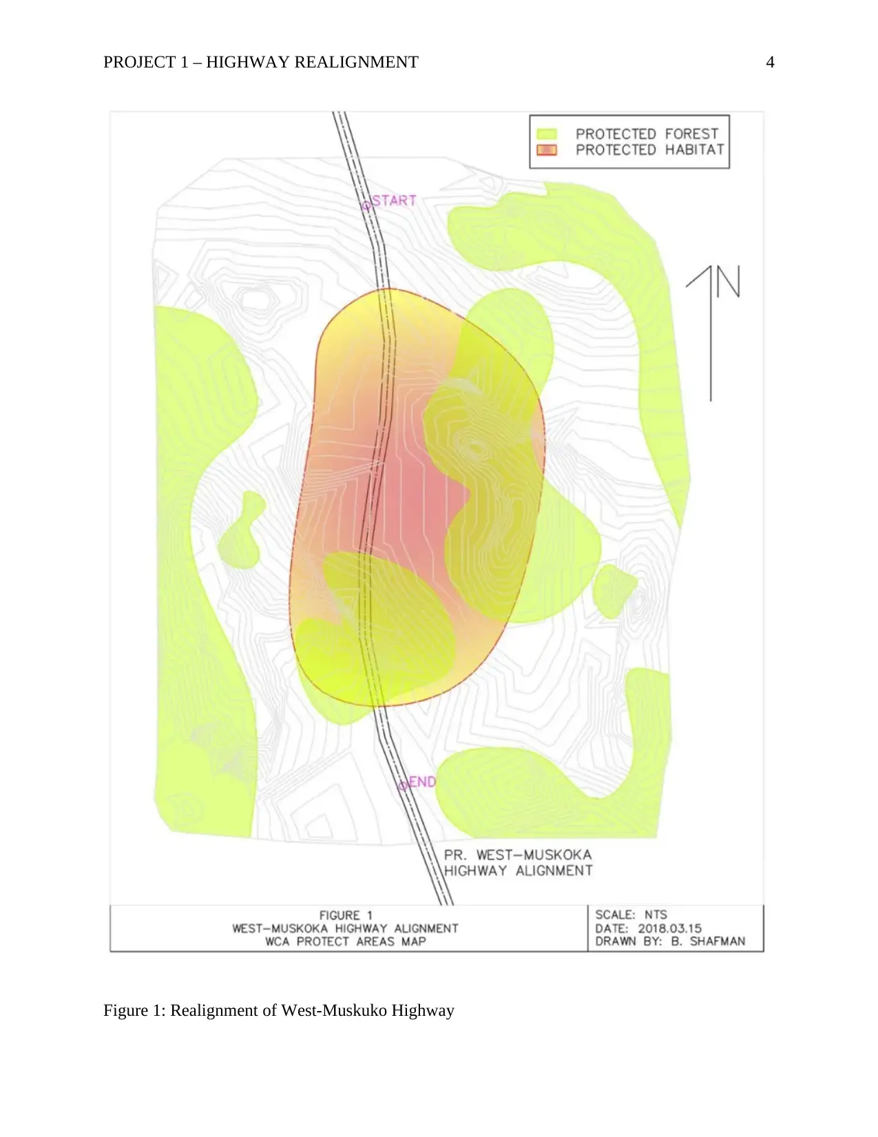
This report details the realignment design of the West City – Muskoka highway, addressing the environmental concerns raised by the West Conservation Authority regarding the original route's impact on protected Carolinian forests and the Bala Bog Monster habitat. The project, undertaken by Taylor Engineering, involved redesigning the highway corridor to bypass these sensitive areas. The design adheres to specific criteria, including a design speed of 100 km/h, a 60-meter right-of-way width, and considerations for cut/fill balance and vertical curve design. The realignment utilizes straight lines, following the route Start – PI1 – PI2 – PI3 – PI4 – End, as shown in the map, and incorporates a four-lane configuration with paved shoulders and a center safety strip. The design process involved careful consideration of topography to minimize construction costs and ensure compliance with the WCA's recommendations. The report includes details on horizontal and vertical alignment, as well as design drawings in Excel sheets and AutoCAD Civil 3D files. The project's successful completion ensures the highway aligns with environmental protection while meeting the specified design parameters.
Document Page
Running head: PROJECT 1 – HIGHWAY REALIGNMENT 1
Project 1 – Highway Realignment
Name
Institution
tabler-icon-diamond-filled.svg

Paraphrase This Document

Need a fresh take? Get an instant paraphrase of this document with our AI Paraphraser
Document Page
PROJECT 1 – HIGHWAY REALIGNMENT 2
Project 1 – Highway Realignment (Response Letter)
Introduction
In light of the design of the highway connecting the West City to the Muskoka’s by
Taylor Engineering in 2014, the design was completed and sent to various authorities and
departments for a review. The bodies that reviewed the design are West City, MTO, and West
Conservation Authority (WCA). Based on the environmental study done along the proposed
corridor, it was found that the route passes through the protected Carolinian forests, and through
the protected Bala Bog Monster habitat. In order to avoid the protected areas, the highway design
is realigned as in the design description below.
Design Description
The proposed realignment of the route corridor is as shown in the map below. The
realistic realignment was established using straight lines (in red) as shown on the map below;
The proposed realignment will therefore follow the route corridor Start – PI1 – PI2 –
PI3 – PI4 – End.
The design speed given for the West-Muskoka Highway Realignment is 100 km/h.
The horizontal alignment design of the road is as done in the excel design sheets attached.
The vertical alignment design of the highway is as done in the excel design sheets
attached.
The drawing designs of the highway are as presented in the AutoCAD Civil 3D file
attached.
In realigning the highway, various factors were considered. First, the realignment had to
follow the guidelines or recommendations proposed by the West Conservation Authority.
Therefore, the design was done such that it passes outside the protected and conserved areas.
Document Page
PROJECT 1 – HIGHWAY REALIGNMENT 3
Another factor considered is the topography of the area. The highway is realigned to pass
through a less ragged landscape in order to reduce construction costs.
The design criteria used for the highway is as follows:
- Proposed design speed 100km/h
- 60 m right of way width
- Balance cut/fill to within1000 m3
- Design vertical curves for SSD (non-illuminated)
- The alignment includes:
- 4 lanes (2 each direction)
- 3.5m lane width
- 3.5m paved shoulder
- 4:1 sloping to match existing grades (day lighting)
- 1.5m wide paved center safety strip
Conclusion
In brief, the design of the West City – Muskoka highway is necessary in order to ensure
that the road is in line with the proposals given in the report by West Conservation Authority.
The realignment of the road is designed to meet the given design criteria. Based on the
environmental study, the proposals put forth, and the subsequent designs, the realignment is done
as presented in the Excel sheets and the Civil 3D designs.
Document Page
PROJECT 1 – HIGHWAY REALIGNMENT 4
Figure 1: Realignment of West-Muskuko Highway
tabler-icon-diamond-filled.svg

Paraphrase This Document

Need a fresh take? Get an instant paraphrase of this document with our AI Paraphraser
Document Page
PROJECT 1 – HIGHWAY REALIGNMENT 5
Appendix
1. Excel Design Sheets – Attached
2. Civil 3D Designs – Attached.
chevron_up_icon
1 out of 5
circle_padding
hide_on_mobile
zoom_out_icon
[object Object]