Incheon Airport Integrated Spatial Management System Report
VerifiedAdded on 2022/09/26
|6
|3360
|37
Report
AI Summary
This report delves into the Incheon International Airport's Integrated Spatial Management System, exploring the application of Building Information Modeling (BIM) and Geographical Information System (GIS) to address challenges in construction and airport management. The report begins with an overview of the airport and its characteristics, followed by a description of the project and the problems faced before implementation. The core of the report focuses on the innovation strategy, emphasizing the importance of BIM and the integration of GIS with BIM, including the use of tools like Revit and ESRI ArcGIS. It details the project's approach to managing building information, leveraging 3D models and virtual globes. The report discusses potential improvements, such as integrating BIM with big data, cloud computing, AI, and machine learning, and the use of RFID data. It highlights the benefits of the system, including enhanced safety, quality, and cost-effectiveness. The report also addresses the potential for further advancements through data-driven BIM and IoT sensors, emphasizing the importance of structured data and cloud computing for improved information exchange and analysis.
Incheon International Airport Integrated Spatial Management System
Student Name, Student Number, Email Address
Executive Summary
Building Information management is a very important aspect in the construction industry.
There are massive challenges which are faced by the construction industry. BIM tools have
the capability to address the issues of the construction industry. There are various types of
BIM tools that are available such as Big data, 4D sequencing and model estimates. In this
report, BIM approach indicates several approaches as an innovation to address the risk
management as well as quality assurance. In this report, it will discuss regarding the Incheon
International Airport Integrated Spatial Management System. At first, this report will discuss
regarding the details of the company. After that, it will discuss regarding the details of the
project as well as problems faced by the organisation before implementing the project. In this
report, it will discuss regarding the innovation strategy regarding this project. In this
particular portion, importance of the BIM is discussed. It also discusses regarding the
integration of GIS and BIM. After that, this report will discuss regarding the various
improvement strategy is discussed. In this portion, how BIM can integrate with big data,
cloud computing, artificial intelligence and machine learning are discussed. In this portion, it
is also discusses regarding the RFID data.
1. INTRODUCTION (TIMES NEW ROMAN BOLD 14 ALL CAPS
1.1.Company Name, Characteristics etc.
Incheon International Airport is treated as one of the largest airport in South
Korea. It is a very busy airport in South Korea. Every year this airport bags the best
airport award from the Airports Council International (Xiong 2020). It is also treated
as the cleanest airport in all over the world. It bagged the best airport of the world
award by Skytrax. It has the capability of tackling 2.7 million tons of cargo. The
length of the cargo space is two million square feet.
Volume of annual flight is increased from 240,000 to 410,000 (Kim, Lee and
Choi 2020). The annual capacity is increased from 30-44 million and the annual cargo
capacity of this airport is from 2.7Mt to 4.5 Mt.
1.2.Project Name, Description etc.
In the Integrated Spatial Management System of the Incheon International Airport,
Geographical Information System unlocks entire potential of data by gripping the
power of maps and spatial analysis. It gives unparallel insight among various types of
data that are not seen in previous times (Khanzadi, Sheikhkhoshkar and
Banihashemi 2020). GIS can empower detailed knowledge regarding their knowledge
and assets.
The geospatial information is available totally relevant to the development of
the sites (Oliver et al. 2020). In this particular project, Virtual Globe needs to be the
main gateway for the GIS information that maximizes the contact frequency for the
non technical users of the airport because it gives the strong environment for users.
Paraphrase This Document
Need a fresh take? Get an instant paraphrase of this document with our AI Paraphraser
Paper Title (use abbreviation if necessary) Surname of the first author
That is why; it is treated as the 3D model based GIS information. In this project there
is a 3D web based provision as well as managing gadget based system in the airport.
By adopting the Building Information Management, Geographical Information System
can be applied to manage the buildings as well as infrastructure spread in the
entire airport by using a two dimensional model base because of large scale of data
processing. They also take Revit for the BIM software as well as ESRI Arc GIS for
GIS based software (Kim, Lee and Choi 2020). These tools are quite capable for
processing of three dimensional data in real time.
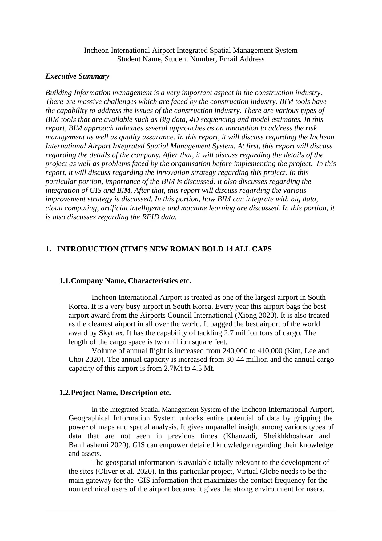
Classification Extension Description
DEM *.bil Data regarding the height
mapping for Tile zone
Point *.poi Information related to Point
of Interest (POI) symbol for
Tile zone.
Billboard *.poi Information related to
Billboard symbol for Tile
Zone
Real3D index *.dat Information related to Real
3D symbol for Tile Zone
Direct Show Surface *.dds Information related to
Satellite image for Tile Zone
Figure 1: BIM project table
Source: Created by author
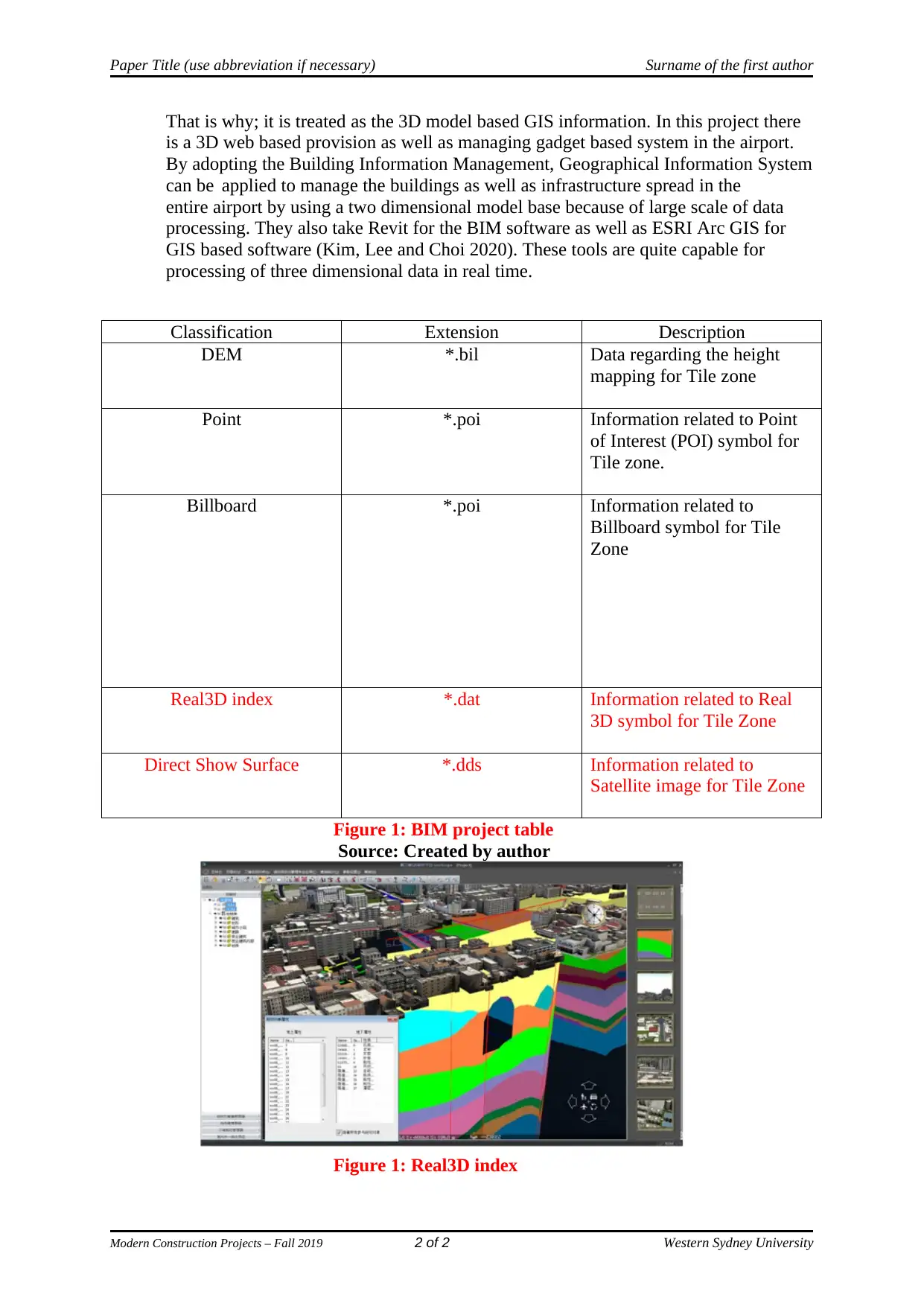
Figure 1: Real3D index
Modern Construction Projects – Fall 2019 2 of 2 Western Sydney University
That is why; it is treated as the 3D model based GIS information. In this project there
is a 3D web based provision as well as managing gadget based system in the airport.
By adopting the Building Information Management, Geographical Information System
can be applied to manage the buildings as well as infrastructure spread in the
entire airport by using a two dimensional model base because of large scale of data
processing. They also take Revit for the BIM software as well as ESRI Arc GIS for
GIS based software (Kim, Lee and Choi 2020). These tools are quite capable for
processing of three dimensional data in real time.
Classification Extension Description
DEM *.bil Data regarding the height
mapping for Tile zone
Point *.poi Information related to Point
of Interest (POI) symbol for
Tile zone.
Billboard *.poi Information related to
Billboard symbol for Tile
Zone
Real3D index *.dat Information related to Real
3D symbol for Tile Zone
Direct Show Surface *.dds Information related to
Satellite image for Tile Zone
Figure 1: BIM project table
Source: Created by author
Figure 1: Real3D index
Modern Construction Projects – Fall 2019 2 of 2 Western Sydney University
Paper Title (use abbreviation if necessary) Surname of the first author
Source: https://www.researchgate.net/figure/Real-3D-
model-of-Wuhan-China_fig2_271951596
2. THE PROBLEM(S)
There is lots of problems that are faced by the airport authority regarding the
construction. For resolving those problems, this project is designed. There is trend to use
some traditional methodologies regarding the construction and other assignments of the
airports. Staffs are not willing to accimilitize to several approaches that has been set to it.
Modification is a slow process. And adopting the change is the need of the growth. After
some onset construction, urgent modification is required that take a long time and it also
takes some costs (Rivera and Christian 2020). Most of the times, there are some incorrect
evaluations of services generate conflicts regarding the construction of the sites. Most of
the times it happens that amount of ordered building materials are of huge number and it
was ordered without any proper approximation.
After the designing of the plan for work, the proper estimation of building material is
totally drawn out (MEHRBOD, STAUB-FRENCH AND TORY 2020). Complexities of
the two dimensional plan may lead to some incorrect calculations eventually causing the
shortage or wastage of the material used for various constructions of the airport.
For resolving those problems, BIM can play vital contribution.
3. THE INNOVATION(S)
The project is mainly focused on the designing of the Geographical Information
System data as well as examines associated with to the CAD/BIM/GIS addition for increasing
the effectiveness for management of the building information by using BIM data erection and
data retrieved from GIS (Okakpu et al. 2020). Geospatial information can be used with the
help of some satellite photos of Google Earth. In this software, various three dimensional
forms of the construction is stored. Many plug associated with the Google Earth requires to be
performed by using some exisisting BIM tools. VWorld tools are also used which includes
some satellite photos related to the airport construction.
With the help of this, it could gain easy access to the building related information
regarding the information available in their own database. For enhanced interoperability
design of the project, there is a huge need of CAD/BIM/GIS addition. It also helps to maintain
the construction as well as maintenance of information which covers the building and
infrastructure life cycles (Phang, Chen and Tiong 2020). This integration is very difficult
because it is considered as the essential handling of large amount of three dimensional data.
There are some essential concepts that can be used to develop this project. It is totally based
on the hierchical structure. It is done as per specification provided by the National BIM
standards.
In this project, Revit is treated as the BIM software and VWorld as the desktop. In this
case, A360 is treated as the Revit-BIM viewer (Oliver et al. 2020). These are connected with
middleware. Middleware contains following parts: - search part is utilized for fetching a data
from the VWorld. Convert part is utilized for modification of the data so that middleware has
a capability to process it. It is used to develop some Revit Objects so that Revit Objects can be
managed within VWorld (Mostafa et al. 2020). Request keyword covers many forms of data.
However, it is very important to utilize the lot number for getting a good address and for
achieving an outstanding outcome because there is a map for performing the registration of a
Modern Construction Projects – Fall 2019 3 of 2 Western Sydney University
⊘ This is a preview!⊘
Do you want full access?
Subscribe today to unlock all pages.
Trusted by 1+ million students worldwide
Paper Title (use abbreviation if necessary) Surname of the first author
land. The outcomes of the search are suggested using the list as well as image. For that
reason, users can able to identify them very easily.
Data conservation portion takes various received data into geometrics and properties
are used internally within the system. The geometry includes three dimensional terrians, 3D
buildings, satellite images, map images, as well as map used for land registration. Property
has the information associated with the lands, region as well as districts. The received data are
modified to the Revit object such as terrain objects, mass objects as well as property line
objects. It is used for mapping of the registration.
Property information is stored in the form of custom user defined parameters for the
specific objects. VWorld middleware applies several functions for preserving the associated
information of the creation of terrain object. It also helps to map with the photographs of the
satellites of the airport construction (Liao et al. 2020). The analysis of the Real 3D format is
not finished. For that reason, a building model format modification function is not furnished
with middleware. Revit building model is fetched as a surface model as well as transferred to
VWorld in KMZ.
Entire model is very complicated and it cannot be directly showed as the hotchpotch in
the VWorld. These models are given through with the help of a web browser links available
in the VWorld.
4. OUTCOME – LIST SPECIFIC BENEFITS INCLUDING ANY DATA ON SAFETY,
QUALITY, COST, OR SCHEDULE
Panel 1 along with Panel 2 highlight the initial showoff and search window for
VWorld middleware of the airport construction (Le, Likhitruangsilp and Yabuki 2020). In this
case, panel 1 display the satellite photography as well as panel 2 utilizes a base map of
VWorld. Panel three highlights an outcome of the site map that displays outcome of the
transformed Revit topography object for a chosen zone of the airport. Panel four highlights
photography mapping outcomes for the Revit topography. The panel six displays the outcome
of addition which has the ability to illustrate the outcome of initial assessment of the buildable
volume which is totally based on the required information.
As this software has the Building Information Management, it enables the safety and
security of the health of the airport workers. In BIM, there are number of concepts that are
available such as Safety Development as well as Protection with the help of Design. These
can be applied very well with the feature of the BIM (Jayasinghe and Waldmann 2020). It
helps to promote collaboration among the various project teams of this project throughout the
entire delivery procedure.
It helps to provide a quality as well as efficient product to the airport authority.
Using BIM in this project is very much cost effective.
5. POSSIBLE IMPROVEMENT(S) ON THIS INNOVATION(S)
Project team may use the data driven Building Information Management can decrease
the construction projects the cost estimation is eighteen percent and it also reduces the project
finishing time by twelve weeks. It has achieved drastically shortening the pre construction
phase (Huang 2020). Internet of Things sensors in machine learning will provide information
on active as well as idle time of the project. Such input can be processed for making the
machines more efficient. Geolocation data of software will allow the logistics to be improved.
Many parts of the project is available when required. It also helps to avoid the downtime.
Weather, airport traffic, community and business activity data help to perform the optimized
Modern Construction Projects – Fall 2019 4 of 2 Western Sydney University
Paraphrase This Document
Need a fresh take? Get an instant paraphrase of this document with our AI Paraphraser
Paper Title (use abbreviation if necessary) Surname of the first author
transformation. Temperature, stress and humidity of the airport can be analysed to detect how
it affects a particular structure.
Economic activity can affect the labour and material expenditures. It will be very
useful for the airport authority (Khanzadi, Sheikhkhoshkar and Banihashemi 2020). It may
happen that they are lots of unstructured data in this project. It is the largest set back in any
big data based applications. This may generates a large amount of data on a regular basis.
These data need to be structured with an appropriate infrastructure to store, curate and activate
them. Then only the intelligence can be generated.
The project team can implement cloud computing into this BIM based projects. As
there are lots of data that is why, cloud based repository becomes very much necessary. A
cloud based repository will help the project team to perform the information exchanges more
frequently (Kim, Lee and Choi 2020). It adds more depth in the data. It gives lots of the
flexibility to the project in terms of location as well as time. Project team may use the
Microsoft Azure Computing Platform which has an ample computing power for setting up a
BIM cloud workplace. It is adopted by Bentley Systems for their cloud solutions. Project team
may use the BIM 360 which is cloud based BIM construction software. It helps to create a
robust cloud based collaborative environments. Cloud based framework helps any person to
access the information regarding the project.
Internet of Things enabled devices is capable of capturing data from the project. The
project will showcase a user interface with the Building Information Management and related
sensor data of Internet of Things which can be used for facility management (Jayasinghe and
Waldmann 2020). They may use some RFID sensors, individual prefab gadgets which can be
trailed with the help of IoT enabled devices. Since the airport construction engages a
comparatively tiny amount of footprint but requires a huge amount of prefabricated portions.
It is logically very complicated tasks for coordinating the RFID data that can be utilized to
extenuating the effect of any type of downstream hold-up in this project (Huang 2020). In
addition to that, data can be inserted into the BIM when it is installed. It also allows some real
time supply of the building in progress. It helps for project of controls and KPIs.
Data collected from various simulations, models and the projects help them to
construct a new construction project. Including machine learning in the BIM process can
decrease the human mistakes (Ali et al. 2020). With the help of Artificial Intelligence used in
BIM software, the project team can complete assignments that may be too detailed to carry
out in the earlier construction phase. Machine learning inspects each BIM elements to classify
and identify every model. If the algorithm is not able to classify an element, then it asks the
human experts but it learns so that it never has to check the classification again.
6. CONCLUSION
BIM tool is basically used for the flow of the information during a project is very
critical. BIM helps the project team to perform the tasks within the assigned deadline. It will
provide a good efficiency. Artificial Intelligence helps the BIM tool to perform the project
very efficiently. With the help of GIS software, project team can perform efficiently the
project of the Incheon International Airport.
Modern Construction Projects – Fall 2019 5 of 2 Western Sydney University
Paper Title (use abbreviation if necessary) Surname of the first author
7. IF YOU HAVE REFERENCES - LIST AT THE END OF REPORT (FOLLOW
HARVARD STYLE
Ali, B., Zahoor, H., Nasir, A.R., Maqsoom, A., Khan, R.W.A. and Mazher, K.M., 2020. BIM-
based claims management system: A centralized information repository for extension of time
claims. Automation in Construction, 110, p.102937.
Hollberg, A., Genova, G. and Habert, G., 2020. Evaluation of BIM-based LCA results for
building design. Automation in Construction, 109, p.102972.
Huang, Y., 2020. Introducing BIM to Construction Management Students: A Case Study of
Using Lego Blocks as Instructional Tool. Journal of Civil Engineering and Architecture, 14,
pp.100-108.
Jayasinghe, L.B. and Waldmann, D., 2020. Development of a BIM-Based Web Tool as a
Material and Component Bank for a Sustainable Construction Industry. Sustainability, 12(5),
p.1766.
Khanzadi, M., Sheikhkhoshkar, M. and Banihashemi, S., 2020. BIM applications toward key
performance indicators of construction projects in Iran. International Journal of Construction
Management, 20(4), pp.305-320.
Kim, I., Lee, Y. and Choi, J., 2020. BIM-based Hazard Recognition and Evaluation
Methodology for Automating Construction Site Risk Assessment. Applied Sciences, 10(7),
p.2335.
Le, H.T.T., Likhitruangsilp, V. and Yabuki, N., 2020. A BIM-Integrated Relational Database
Management System for Evaluating Building Life-Cycle Costs. Engineering Journal, 24(2),
pp.75-86.
Liao, L., Teo, E.A.L., Chang, R. and Li, L., 2020. Investigating Critical Non-Value Adding
Activities and Their Resulting Wastes in BIM-Based Project Delivery. Sustainability, 12(1),
p.355.
Mehrbod, S., Staub-French, S. and Tory, M., 2020. BIM-based building design coordination:
processes, bottlenecks, and considerations. Canadian Journal of Civil Engineering, 47(1),
pp.25-36.
Mostafa, S., Kim, K.P., Tam, V.W. and Rahnamayiezekavat, P., 2020. Exploring the status,
benefits, barriers and opportunities of using BIM for advancing prefabrication practice.
International Journal of Construction Management, 20(2), pp.146-156.
Okakpu, A., GhaffarianHoseini, A., Tookey, J., Haar, J. and Ghaffarianhoseini, A., 2020.
Exploring the environmental influence on BIM adoption for refurbishment project using
structural equation modelling. Architectural Engineering and Design Management, 16(1),
pp.41-57.
Oliver, S., Seyedzadeh, S., Pour Rahimian, F., Dawood, N. and Rodriguez, S., 2020. Cost-
effective as-built BIM modelling using 3D point clouds and photogrammetry. Current Trends
in Civil & Structural Engineering, 4(5).
Panteli, C., Polycarpou, K., Morsink-Georgalli, F.Z., Stasiuliene, L., Pupeikis, D., Jurelionis,
A. and Fokaides, P.A., 2020, January. Overview of BIM integration into the Construction
Sector in European Member States and European Union Acquis. In IOP Conference Series:
Earth and Environmental Science (Vol. 410, No. 1, p. 012073). IOP Publishing.
Phang, T.C., Chen, C. and Tiong, R.L., 2020. New Model for Identifying Critical Success
Factors Influencing BIM Adoption from Precast Concrete Manufacturers’ View. Journal of
Construction Engineering and Management, 146(4), p.04020014.
Rivera, J. and Christian, C., 2020. BIM for Bridges and Structures Pooled Fund Initiative.
Xiong, Y., 2020. A BIM-based Interoperability Platform in Support of Building Operation
and Energy Management (Doctoral dissertation, Virginia Tech).
Modern Construction Projects – Fall 2019 6 of 2 Western Sydney University
⊘ This is a preview!⊘
Do you want full access?
Subscribe today to unlock all pages.
Trusted by 1+ million students worldwide
1 out of 6

Your All-in-One AI-Powered Toolkit for Academic Success.
+13062052269
info@desklib.com
Available 24*7 on WhatsApp / Email
![[object Object]](/_next/static/media/star-bottom.7253800d.svg)
Unlock your academic potential
Copyright © 2020–2026 A2Z Services. All Rights Reserved. Developed and managed by ZUCOL.