ENVS805 Water Quality Analysis Report: Mars Creek, Macquarie Uni
VerifiedAdded on 2022/10/01
|12
|2505
|57
Report
AI Summary
This report presents a water quality analysis of Mars Creek at Macquarie University, conducted as part of the ENVS805 course. The study investigates the relationship between contaminants and water quality using collected water samples and various analytical methods, including the Grid GIS method. Six key parameters, including dissolved oxygen, ammonia nitrogen, nitrate nitrogen, nitrite nitrogen, total nitrogen, and total phosphorus, were analyzed. The assessment utilized single-factor and comprehensive pollution indices, alongside Geo-statistical analysis and GIS to visualize spatial pollution characteristics. The results indicate the presence of various pollutants, with total phosphorus, nitrite nitrogen, and total nitrogen exceeding Category III standards. The report references Australian and New Zealand guidelines for water quality and emphasizes the importance of sustainable development principles and community involvement in water resource management. The methodology included sampling, chemical analysis, and data interpretation, with environmental actions and risks also being considered. The report concludes by highlighting the significance of the ANZAC guidelines for addressing environmental issues and emphasizes the influence of seasonal climate variations on water quality. The report is based on the assignment brief, which includes the analysis of the creek, data assessment, and benchmarking against ANZECC guidelines with at least 10 references from quality and credible peer-reviewed journals.
A
ANALYSIS
REPORT
ON
THE
TOPIC
“WATER QUALITY ANALYSIS”
BY
STUDENT NAME
ROLL NO
SUBMITTED TO: PROFESSOR NAME
MACQUARIE UNIVERSITY
ANALYSIS
REPORT
ON
THE
TOPIC
“WATER QUALITY ANALYSIS”
BY
STUDENT NAME
ROLL NO
SUBMITTED TO: PROFESSOR NAME
MACQUARIE UNIVERSITY
Paraphrase This Document
Need a fresh take? Get an instant paraphrase of this document with our AI Paraphraser

ABSTRACT
This paper deals with the water quality analysis report for the location 4 - Mars Creek in
Macquarie University situated at Balaclava Rd, Macquarie Park NSW 2109, Australia. In this
report we will find the relationship between the contaminants and the water present in the
Mars Creek. Water quality assessment at the mars creek watershed scale requires not only an
investigation of water pollution and the recognition of main pollution factors, but also the
identification of polluted risky reason resulted in polluted surrounding river sections. To
realize this objective, we collected water samplings from various sites in mars creek with
Grid GIS method to analyze six parameters including dissolved oxygen (DO), ammonia
nitrogen (NH3-N), nitrate nitrogen (NO3-N), nitrite nitrogen (NO2-N), total nitrogen (TN) and
total phosphorus (TP). Single factor pollution index and comprehensive pollution index were
adopted to explore main water pollutants and evaluate water quality pollution level. Based on
two evaluate methods, Geo-statistical analysis and Geographical Information System (GIS)
were used to visualize the spatial pollution characteristics and identifying potential polluted
risky regions. The results indicated that the general water quality in the watershed has been
exposed to various pollutants, in which TP, NO2-N and TN were the main pollutants and
seriously exceeded the standard of Category III.
INTRODUCTION
With the rapid growth in economic and social development in the country, non-point source
pollution to the environment from livestock and poultry industry, aquaculture industry,
planting industry, and rural domestic sewage to our living space centered on the Earth has
drawn much attention to the public and policy-makers (Niemi et al., 1990). This document
updates the Australian water quality guidelines for fresh and marine waters released in 1992
(ANZECC 1992).Specifically, this document outlines the important principles, objectives and
philosophical basis of underpinning the development and application of the guidelines, the
management framework recommended for applying the water quality guidelines to the
natural and semi-natural marine and fresh water resources in Australia and New Zealand,
provides a summary of the water quality guidelines proposed to protect and manage the
environmental values supported by the water resources; provides advice on designing and
implementing water quality monitoring and assessment programs has also been revised using
data, relevant literature, and other available information to at least 1996
(https://www.ijltet.org/journal/151736924028.%202064.pdf, 2018).
BACKGROUND
The current guidelines including this working documentation is taken from a revision of the
NWQMS guidelines published in 1992 (ANZECC 1992). The revision was necessary to
incorporate current scientific, national and international information in a clear and
understandable format, ensuring that the guidelines complement major policy initiatives and
directions undertaken at the state and federal levels in the areas of ecologically sustainable
development and water resource management, promote a more realistic approach to aquatic
ecosystem management, incorporate more detailed guidance on how to refine national or
regional guidelines for site-specific application, it is important input to the review process
from Australia and New Zealand has included public submissions on the 1992 Guidelines.
Earlier drafts of the revised document are the most recent local and overseas scientific and
resource management documents and information relevant overseas water quality guideline
documents and government submissions. In accordance with the script of philosophy of the
1992 Guidelines, the chapters in this document describe how to apply state-of-the-art
practices of water resource management and assessment for the protection of the
environmental values.
GUIDING PRINCIPLES
The Australian and New Zealand Guidelines for Fresh and Marine Water Quality are initially
based on the philosophy of ecologically sustainable development (ESD). The Australian
National Strategy for Ecologically Sustainable Development (ESD Steering Committee 1992)
defined ESD is defined as the development of ecological systems by conserving and
enhancing the community’s resources on the ecological processes on which life depends are
maintained along with the total quality of life aiming now and in the future that could be
increased (Yan et al., 2015). Illustrating more simply the ESD is a development process which
aims to meet the needs of Australians today, while conserving our ecosystems to the benefits
of future generations. The need to comply with ESD principles is being included in statutes
⊘ This is a preview!⊘
Do you want full access?
Subscribe today to unlock all pages.
Trusted by 1+ million students worldwide
throughout Australia, with the commitment to continuous environmental improvement
through comprehensive and integrated public policy. The Purpose and Principles in the
Resource Management Act (1991) was to set out the philosophy and approach for water
management in Australia (Waterquality.gov.au, 2019). The purpose of the RMA is to promote
sustainable management, which is broadly equivalent to the ESD philosophy. The Guidelines
are also based on the policies and principles of the Australian National Water Quality
Management Strategy as explained in ANZECC and ARMCANZ (1994) (Yan et al., 2019). The
principles includes ecologically sustainable development, an integrated approach to water
quality management, including establishment of the environmental values and development
of management plans, community involvement in water resource management and
government endorsement of the water quality policy objectives (Meng, 2019). Four further
guiding principles have also been adopted by the Australian’s are: A coordinated and
cooperative approach to water quality management is vital and involves all spheres of the
community, government local and indigenous groups and the private sector. The high
variability and complexity inherent in natural water resources needs to be recognised and
taken into account when evaluating water quality or developing management strategies.
Water resources are special features of the environment and their quality and integrity should
be conserved and managed according to the intent of the Australian National Strategy for
Ecologically Sustainable Development, the Wetlands Policy of the Commonwealth
Government of Australia and the National Strategy for the Conservation of Australia’s
Biological Diversity (Waterquality.gov.au, 2019). Current research results shows the inter-
relationships between ecological processes, water quality and the biota and the dissemination
of these findings in a readily usable form which are essential for effective management of
water resources.
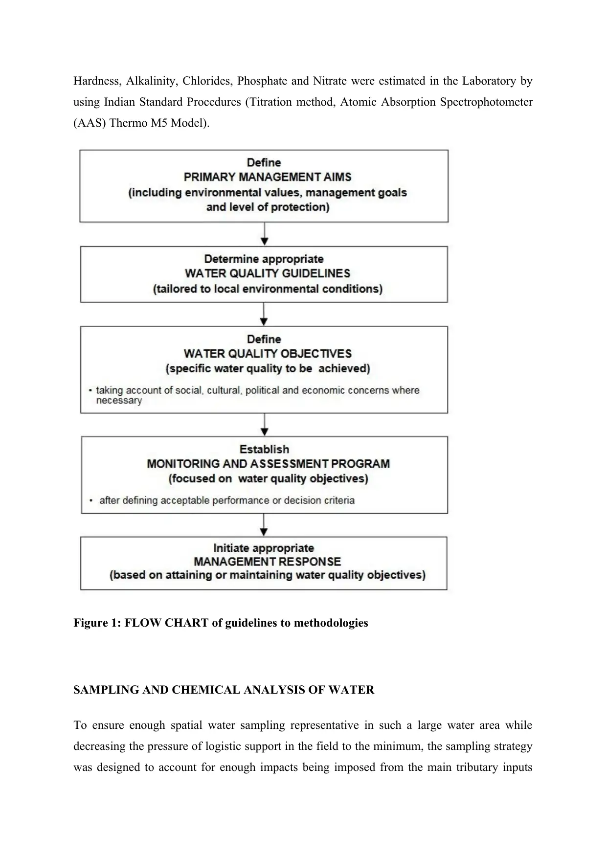
MATERIALS AND METHODOLOGIES
The Water Samples from Mars creek were collected from different sites in the morning hours
between 10 to 12 am in Polythene bottle regularly for every month. The Water samples were
immediately brought in to Laboratory for the Estimation of various Physico-chemical
parameters, like temperature of water and pH of water that were recorded at the time of
sample collection by using Thermometer and Pocket Digital pH Meter (Construction
Environmental Management Plan, 2019). Meanwhile other Parameters like DO, TDS, Free CO2,
through comprehensive and integrated public policy. The Purpose and Principles in the
Resource Management Act (1991) was to set out the philosophy and approach for water
management in Australia (Waterquality.gov.au, 2019). The purpose of the RMA is to promote
sustainable management, which is broadly equivalent to the ESD philosophy. The Guidelines
are also based on the policies and principles of the Australian National Water Quality
Management Strategy as explained in ANZECC and ARMCANZ (1994) (Yan et al., 2019). The
principles includes ecologically sustainable development, an integrated approach to water
quality management, including establishment of the environmental values and development
of management plans, community involvement in water resource management and
government endorsement of the water quality policy objectives (Meng, 2019). Four further
guiding principles have also been adopted by the Australian’s are: A coordinated and
cooperative approach to water quality management is vital and involves all spheres of the
community, government local and indigenous groups and the private sector. The high
variability and complexity inherent in natural water resources needs to be recognised and
taken into account when evaluating water quality or developing management strategies.
Water resources are special features of the environment and their quality and integrity should
be conserved and managed according to the intent of the Australian National Strategy for
Ecologically Sustainable Development, the Wetlands Policy of the Commonwealth
Government of Australia and the National Strategy for the Conservation of Australia’s
Biological Diversity (Waterquality.gov.au, 2019). Current research results shows the inter-
relationships between ecological processes, water quality and the biota and the dissemination
of these findings in a readily usable form which are essential for effective management of
water resources.
MATERIALS AND METHODOLOGIES
The Water Samples from Mars creek were collected from different sites in the morning hours
between 10 to 12 am in Polythene bottle regularly for every month. The Water samples were
immediately brought in to Laboratory for the Estimation of various Physico-chemical
parameters, like temperature of water and pH of water that were recorded at the time of
sample collection by using Thermometer and Pocket Digital pH Meter (Construction
Environmental Management Plan, 2019). Meanwhile other Parameters like DO, TDS, Free CO2,
Paraphrase This Document
Need a fresh take? Get an instant paraphrase of this document with our AI Paraphraser
Hardness, Alkalinity, Chlorides, Phosphate and Nitrate were estimated in the Laboratory by
using Indian Standard Procedures (Titration method, Atomic Absorption Spectrophotometer
(AAS) Thermo M5 Model).
Figure 1: FLOW CHART of guidelines to methodologies
SAMPLING AND CHEMICAL ANALYSIS OF WATER
To ensure enough spatial water sampling representative in such a large water area while
decreasing the pressure of logistic support in the field to the minimum, the sampling strategy
was designed to account for enough impacts being imposed from the main tributary inputs
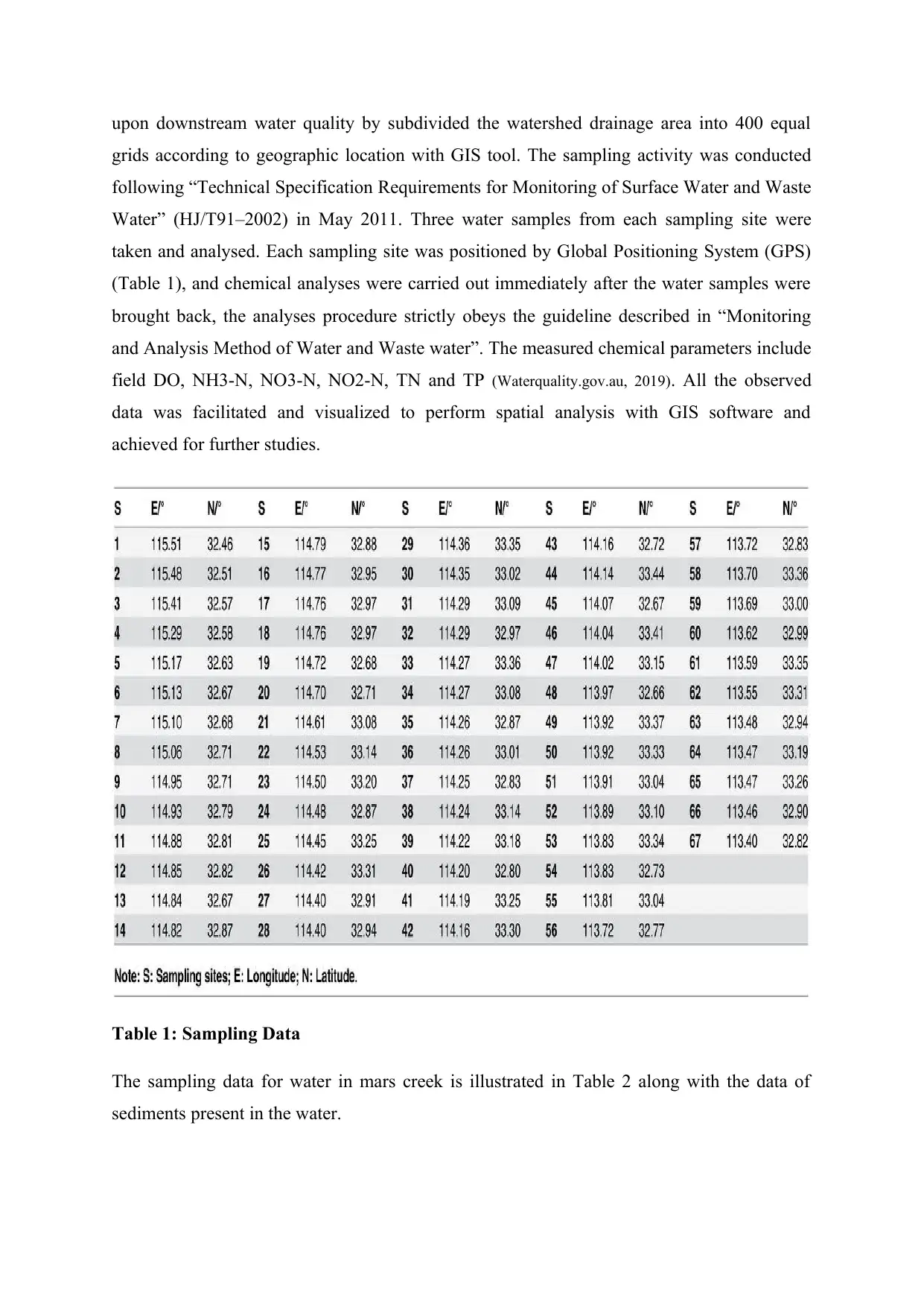
upon downstream water quality by subdivided the watershed drainage area into 400 equal
grids according to geographic location with GIS tool. The sampling activity was conducted
following “Technical Specification Requirements for Monitoring of Surface Water and Waste
Water” (HJ/T91–2002) in May 2011. Three water samples from each sampling site were
taken and analysed. Each sampling site was positioned by Global Positioning System (GPS)
(Table 1), and chemical analyses were carried out immediately after the water samples were
brought back, the analyses procedure strictly obeys the guideline described in “Monitoring
and Analysis Method of Water and Waste water”. The measured chemical parameters include
field DO, NH3-N, NO3-N, NO2-N, TN and TP (Waterquality.gov.au, 2019). All the observed
data was facilitated and visualized to perform spatial analysis with GIS software and
achieved for further studies.
Table 1: Sampling Data
The sampling data for water in mars creek is illustrated in Table 2 along with the data of
sediments present in the water.
⊘ This is a preview!⊘
Do you want full access?
Subscribe today to unlock all pages.
Trusted by 1+ million students worldwide
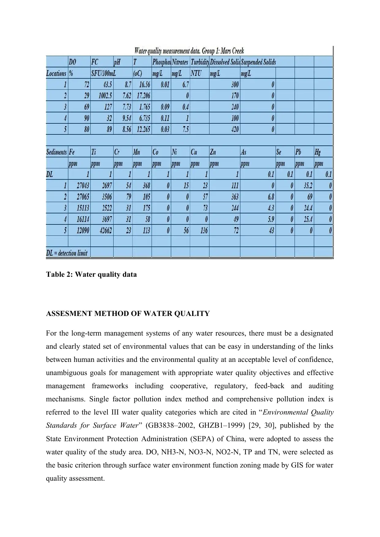
Table 2: Water quality data
ASSESMENT METHOD OF WATER QUALITY
For the long-term management systems of any water resources, there must be a designated
and clearly stated set of environmental values that can be easy in understanding of the links
between human activities and the environmental quality at an acceptable level of confidence,
unambiguous goals for management with appropriate water quality objectives and effective
management frameworks including cooperative, regulatory, feed-back and auditing
mechanisms. Single factor pollution index method and comprehensive pollution index is
referred to the level III water quality categories which are cited in “Environmental Quality
Standards for Surface Water” (GB3838–2002, GHZB1–1999) [29, 30], published by the
State Environment Protection Administration (SEPA) of China, were adopted to assess the
water quality of the study area. DO, NH3-N, NO3-N, NO2-N, TP and TN, were selected as
the basic criterion through surface water environment function zoning made by GIS for water
quality assessment.
Paraphrase This Document
Need a fresh take? Get an instant paraphrase of this document with our AI Paraphraser
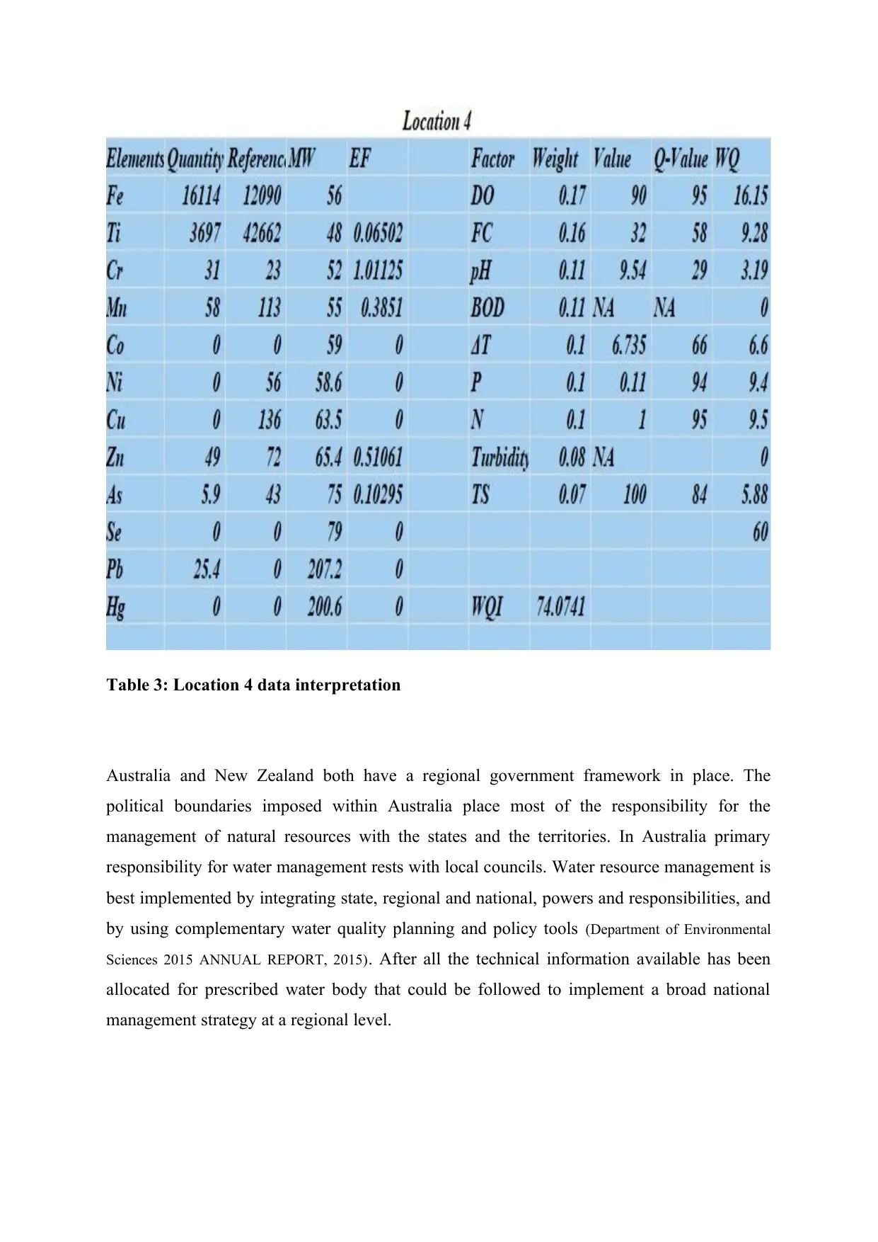
Table 3: Location 4 data interpretation
Australia and New Zealand both have a regional government framework in place. The
political boundaries imposed within Australia place most of the responsibility for the
management of natural resources with the states and the territories. In Australia primary
responsibility for water management rests with local councils. Water resource management is
best implemented by integrating state, regional and national, powers and responsibilities, and
by using complementary water quality planning and policy tools (Department of Environmental
Sciences 2015 ANNUAL REPORT, 2015). After all the technical information available has been
allocated for prescribed water body that could be followed to implement a broad national
management strategy at a regional level.
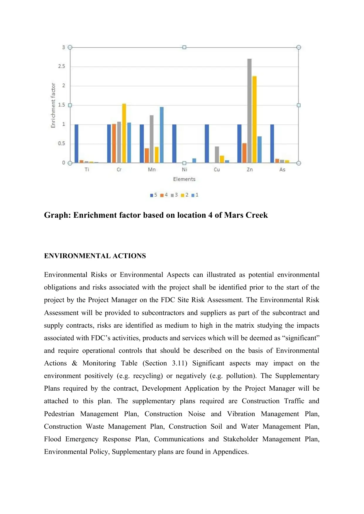
Graph: Enrichment factor based on location 4 of Mars Creek
ENVIRONMENTAL ACTIONS
Environmental Risks or Environmental Aspects can illustrated as potential environmental
obligations and risks associated with the project shall be identified prior to the start of the
project by the Project Manager on the FDC Site Risk Assessment. The Environmental Risk
Assessment will be provided to subcontractors and suppliers as part of the subcontract and
supply contracts, risks are identified as medium to high in the matrix studying the impacts
associated with FDC’s activities, products and services which will be deemed as “significant”
and require operational controls that should be described on the basis of Environmental
Actions & Monitoring Table (Section 3.11) Significant aspects may impact on the
environment positively (e.g. recycling) or negatively (e.g. pollution). The Supplementary
Plans required by the contract, Development Application by the Project Manager will be
attached to this plan. The supplementary plans required are Construction Traffic and
Pedestrian Management Plan, Construction Noise and Vibration Management Plan,
Construction Waste Management Plan, Construction Soil and Water Management Plan,
Flood Emergency Response Plan, Communications and Stakeholder Management Plan,
Environmental Policy, Supplementary plans are found in Appendices.
⊘ This is a preview!⊘
Do you want full access?
Subscribe today to unlock all pages.
Trusted by 1+ million students worldwide
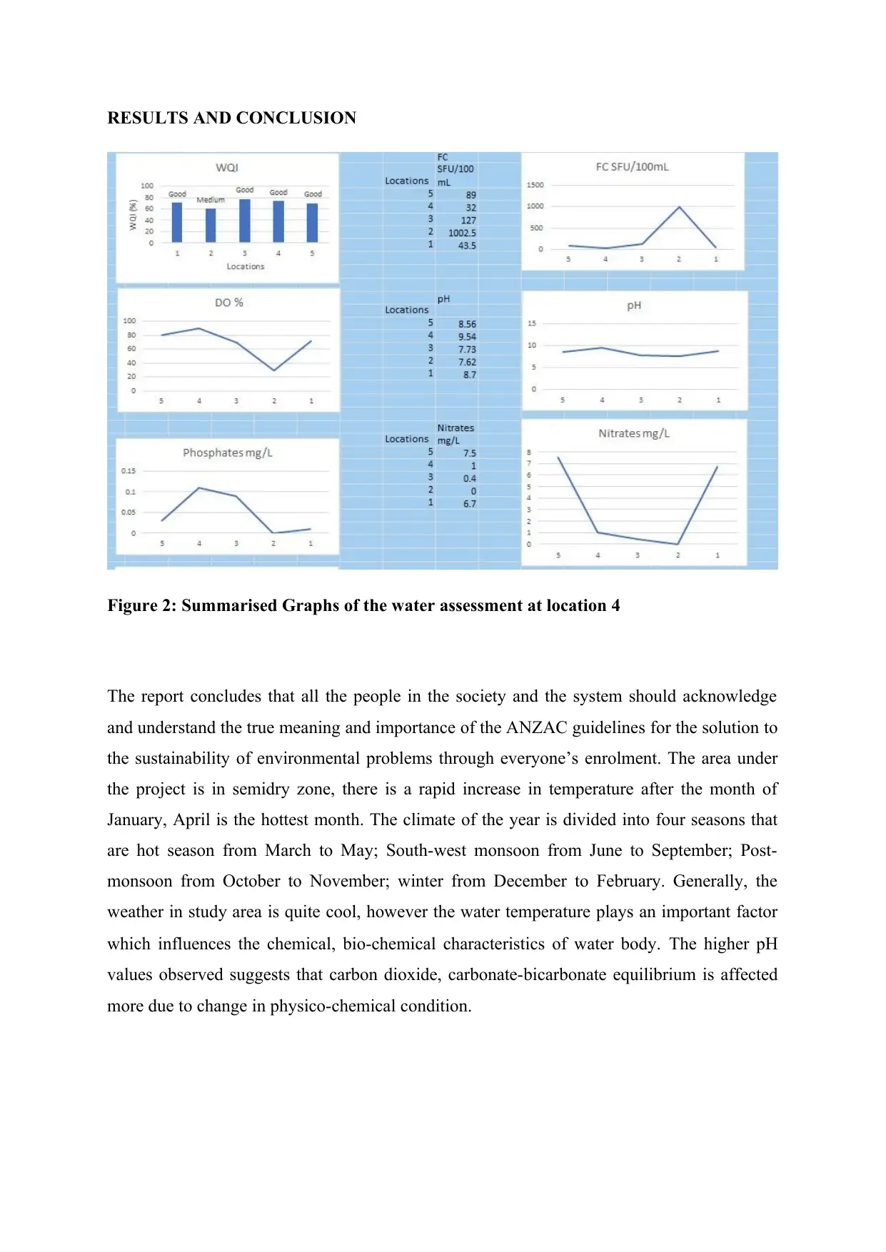
RESULTS AND CONCLUSION
Figure 2: Summarised Graphs of the water assessment at location 4
The report concludes that all the people in the society and the system should acknowledge
and understand the true meaning and importance of the ANZAC guidelines for the solution to
the sustainability of environmental problems through everyone’s enrolment. The area under
the project is in semidry zone, there is a rapid increase in temperature after the month of
January, April is the hottest month. The climate of the year is divided into four seasons that
are hot season from March to May; South-west monsoon from June to September; Post-
monsoon from October to November; winter from December to February. Generally, the
weather in study area is quite cool, however the water temperature plays an important factor
which influences the chemical, bio-chemical characteristics of water body. The higher pH
values observed suggests that carbon dioxide, carbonate-bicarbonate equilibrium is affected
more due to change in physico-chemical condition.
Paraphrase This Document
Need a fresh take? Get an instant paraphrase of this document with our AI Paraphraser
REFERENCES
Niemi, G., DeVore, P., Detenbeck, N., Taylor, D., Lima, A., Pastor, J., Yount, J. and Naiman,
R. (1990). Overview of case studies on recovery of aquatic systems from
disturbance. Environmental Management, 14(5), pp.571-587.
https://www.ijltet.org/journal/151736924028.%202064.pdf. (2018). International Journal of
Latest Trends in Engineering and Technology, 9(3).
Yan, C., Zhang, W., Zhang, Z., Liu, Y., Deng, C. and Nie, N. (2019). Assessment of Water
Quality and Identification of Polluted Risky Regions Based on Field Observations & GIS in
the Honghe River Watershed, China.
Meng, W. (2019). Integrated assessment of river health based on water quality, aquatic life
and physical habitat. - PubMed - NCBI. [online] Ncbi.nlm.nih.gov. Available at:
https://www.ncbi.nlm.nih.gov/pubmed/19862913 [Accessed 5 Oct. 2019].
Yan, C., Zhang, W., Zhang, Z., Liu, Y., Deng, C. and Nie, N. (2015). Assessment of Water
Quality and Identification of Polluted Risky Regions Based on Field Observations & GIS in
the Honghe River Watershed, China. PLOS ONE, 10(3), p.e0119130.
Waterquality.gov.au. (2019). NATIONAL WATER QUALITY MANAGEMENT STRATEGY.
[online] Available at: https://www.waterquality.gov.au/sites/default/files/documents/anzecc-
armcanz-2000-guidelines-vol1.pdf [Accessed 5 Oct. 2019].
Construction Environmental Management Plan. (2019). [ebook] Macquarie: FDC, pp.1-150.
Available at: https://www.mq.edu.au/about/about-the-university/our-campus/campus-
development-plan/central-courtyard-precinct/central-courtyard-pdfs/MUCCP-Construction-
Environmental-Management-Plan-Rev-E-1.pdf [Accessed 5 Oct. 2019].
Department of Environmental Sciences 2015 ANNUAL REPORT. (2015). [ebook]
Macquaire: Department of environmental sciences, pp.2-18. Available at:
https://www.mq.edu.au/about/about-the-university/faculties-and-departments/faculty-of-

science-and-engineering/departments-and-centres/department-of-environmental-sciences/
Annual-Report-2015_DES.pdf [Accessed 5 Oct. 2019].
Annual-Report-2015_DES.pdf [Accessed 5 Oct. 2019].
⊘ This is a preview!⊘
Do you want full access?
Subscribe today to unlock all pages.
Trusted by 1+ million students worldwide
1 out of 12
Your All-in-One AI-Powered Toolkit for Academic Success.
+13062052269
info@desklib.com
Available 24*7 on WhatsApp / Email
![[object Object]](/_next/static/media/star-bottom.7253800d.svg)
Unlock your academic potential
Copyright © 2020–2026 A2Z Services. All Rights Reserved. Developed and managed by ZUCOL.