Implementing Regular Expressions for Decoding METAR Weather Data
VerifiedAdded on 2019/09/16
|5
|1902
|886
Homework Assignment
AI Summary
This assignment requires the creation of regular expressions to decode METAR (Meteorological Aerodrome Report) weather reports, specifically focusing on the North American format. The task involves writing a script that reads a single-line METAR report from a text file and extracts various tokens of information. The script's output should include the report type (METAR or SPECI), station identifier, date and time, and specific flags like 'AUTO' or 'COR'. It should also extract wind data (direction, speed, gusts, and variable directions), visibility, weather phenomena (e.g., rain), cloud conditions, temperature, dew point, and barometric pressure. The assignment emphasizes understanding the METAR format and applying regular expressions to effectively parse and extract the relevant data from the report, demonstrating proficiency in pattern matching and data extraction techniques relevant to AI and data science.
Working individually you will create a series of regular expressions that identify different parts composing a
METAR.
METARs are reports assembled with a particular format that is easy to decode with computer systems using
regular expressions.
These reports typically come in two forms: North American METARs and International METARs. Create a
series of regular expressions that decode each token of information using the North American METAR form.
You can find METAR reports at the following address:
http://weather.noaa.gov/weather/metar.shtml.
In order to find the weather information you need to get a METAR report from any airport you wish utilizing
the appropriate code (Baltimore-Washington International is KBWI) and then apply the different regular
expressions to identify each token and eventually extract it from the report.
Your homework submission should be a script that reads a single line METAR from a file named:
metar.txt Your script output (to the shell screen) should include:
1. the report type: either METAR or SPECI for “Special Report”
2. the station identifies (four characters starting with a K)
3. Day of the month and time the report was filed
4. If the token ‘AUTO’ is present, you should output “This is a fully automated report”
5. If the token ‘COR’ is present, you should output “This is a corrected observation”
6. Wind direction and speed, wind gusting, and variable wind directions
7. Visibility in statute miles
8. Light, medium, or heavy rain (-RA|RA|+RA)
9. Cloud Conditions: [0 or more occurrences of each of the following]
a. Sky Clear
b. Few Clouds <altitude>
c. Scattered Clouds <altitude>
d. Broken Clouds <altitude>
e. Overcast Clouds <altitude>
10. Temperature
11. Dew Point
12. Barometric Pressure
13. If the token ‘TH’ is present, you should output “Thunderstorms reported in the area”
Paraphrase This Document
Need a fresh take? Get an instant paraphrase of this document with our AI Paraphraser
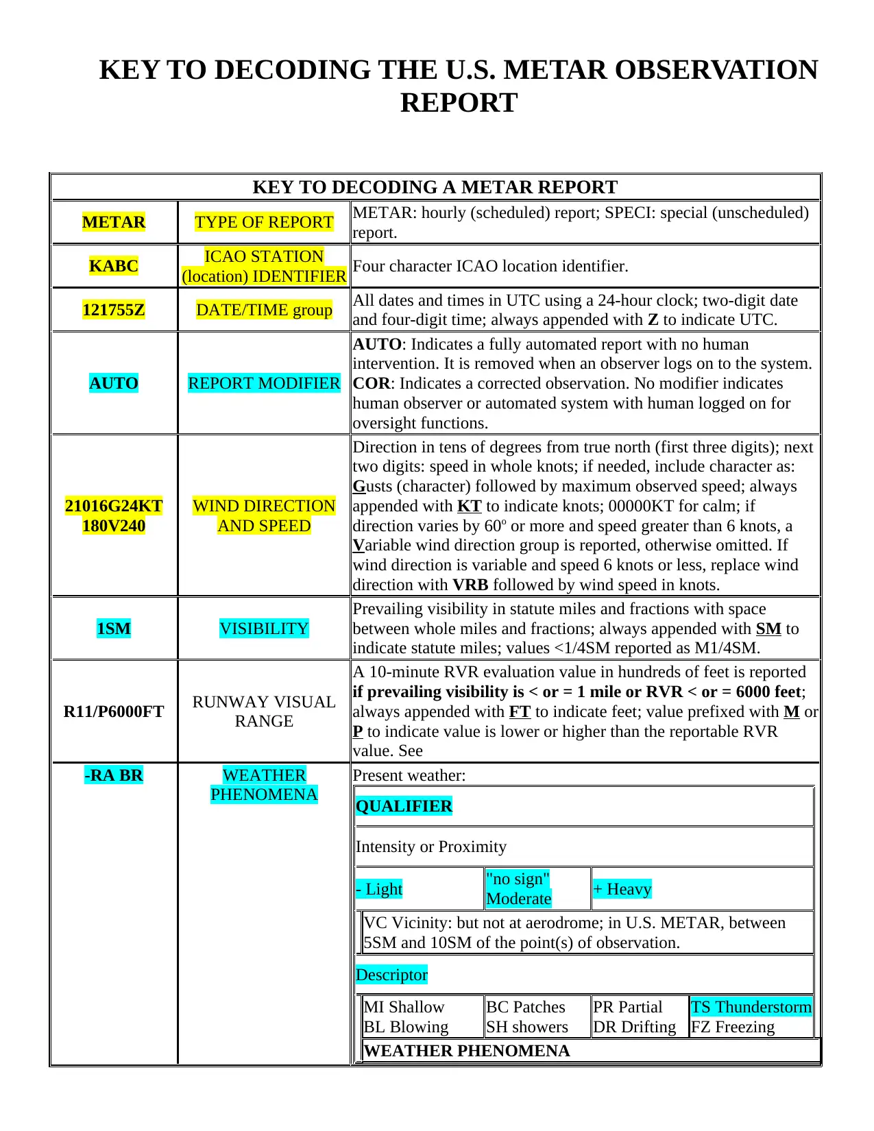
KEY TO DECODING THE U.S. METAR OBSERVATION
REPORT
KEY TO DECODING A METAR REPORT
METAR TYPE OF REPORT METAR: hourly (scheduled) report; SPECI: special (unscheduled)
report.
KABC ICAO STATION
(location) IDENTIFIER Four character ICAO location identifier.
121755Z DATE/TIME group All dates and times in UTC using a 24-hour clock; two-digit date
and four-digit time; always appended with Z to indicate UTC.
AUTO REPORT MODIFIER
AUTO: Indicates a fully automated report with no human
intervention. It is removed when an observer logs on to the system.
COR: Indicates a corrected observation. No modifier indicates
human observer or automated system with human logged on for
oversight functions.
21016G24KT
180V240
WIND DIRECTION
AND SPEED
Direction in tens of degrees from true north (first three digits); next
two digits: speed in whole knots; if needed, include character as:
Gusts (character) followed by maximum observed speed; always
appended with KT to indicate knots; 00000KT for calm; if
direction varies by 60o or more and speed greater than 6 knots, a
Variable wind direction group is reported, otherwise omitted. If
wind direction is variable and speed 6 knots or less, replace wind
direction with VRB followed by wind speed in knots.
1SM VISIBILITY
Prevailing visibility in statute miles and fractions with space
between whole miles and fractions; always appended with SM to
indicate statute miles; values <1/4SM reported as M1/4SM.
R11/P6000FT RUNWAY VISUAL
RANGE
A 10-minute RVR evaluation value in hundreds of feet is reported
if prevailing visibility is < or = 1 mile or RVR < or = 6000 feet;
always appended with FT to indicate feet; value prefixed with M or
P to indicate value is lower or higher than the reportable RVR
value. See
-RA BR WEATHER
PHENOMENA
Present weather:
QUALIFIER
Intensity or Proximity
- Light "no sign"
Moderate + Heavy
VC Vicinity: but not at aerodrome; in U.S. METAR, between
5SM and 10SM of the point(s) of observation.
Descriptor
MI Shallow
BL Blowing
BC Patches
SH showers
PR Partial
DR Drifting
TS Thunderstorm
FZ Freezing
WEATHER PHENOMENA
Precipitation
DZ Drizzle
IC Ice Crystals
UP Unknown
in automated
observations
RA Rain
PL Ice pellets
SN Snow
GR Hail
SG Snow grains
GS Small hail/
snow pellets
Obscuration
BR Mist (< or =
5/8SM)
SA Sand
FU Smoke
HZ Haze
VA Volcanic
Ash
PY Spray
DU Widespread
Dust
Other
SQ Squall
FC Funnel Cloud
SS Sandstorm
+FC Tornado/
Waterspout
DS
Duststorm
PO Well
developed
dust/sand whirls
BKN015
OVC025 SKY CONDITION
Cloud amount and height: CLR (In automated METAR reports
only, no clouds detected below 12000 feet.); SKy Clear 0/8; FEW
1/8-2/8; SCattered 3/8-4/8; BroKeN 5/8-7/8; OVerCast 8/8; 3-digit
height of base in hundreds of feet; followed by Towering CUmulus
or CumulonimBus if present. For an observed sky: Vertical
Visibility followed by vertical veisibility in hundreds of feet into
the obscuration, example: VV004. More than 1 layer may be
reported.
06/04 TEMPERATURE/DEW
POINT
Each is reported in whole degrees Celsius using two digits; values
are separated by a solidus (/); sub-zero values are prefixed with an
M (minus).
A2990 ALTIMETER
Altimeter setting (in U.S. reports) is always prefixed with an A
indicating inches of mercury; reported using four digits: tens, units,
tenths, and hundredths.
The following groups are reported in the Remarks section of the METAR report
RMK REMARKS
IDENTIFIER
Remarks includes clarifying or augmenting data concerning
elements in the body of the METAR, additive coded data and
maintenance data.
TORNADO,
FUNNEL
CLOUD or
WATERSPOUT
TORNADIC
ACTIVITY
Augmented; report should include TORNADO, FUNNEL CLOUD
or WATERSPOUT, time (after the hour) of beginning/end,
location, movement; e.g., TORNADO B25 N MOVE E
AO2
TYPE OF
AUTOMATED
STATION
AO1; automated station without a precipitation descriminator.
AO2; automated station with precipitation descriminator.
PK WND
20032/25 PEAK WIND
PK WND dddff(F)/(hh)mm; direction in tens of degrees, speed in
whole knots, time in minutes after the hour. Only minutes after the
hour is included if the hour can be inferred from the report.
WSHFT 1715 WIND SHIFT
WSHFT followed by hours and minutes of occurrence. The term
FROPA may be entered after the time if it is reasonably certain that
the wind shift was a result of a frontal passage.
VIS 3/4V1 1/2 VARIABLE VIS vnvnvnvn vnVvxvxvx vxvx; reported if prevailing visibility is <3
⊘ This is a preview!⊘
Do you want full access?
Subscribe today to unlock all pages.
Trusted by 1+ million students worldwide
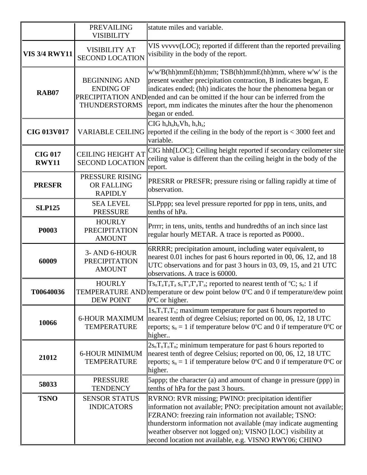
PREVAILING
VISIBILITY
statute miles and variable.
VIS 3/4 RWY11 VISIBILITY AT
SECOND LOCATION
VIS vvvvv(LOC); reported if different than the reported prevailing
visibility in the body of the report.
RAB07
BEGINNING AND
ENDING OF
PRECIPITATION AND
THUNDERSTORMS
w'w'B(hh)mmE(hh)mm; TSB(hh)mmE(hh)mm, where w'w' is the
present weather precipitation contraction, B indicates began, E
indicates ended; (hh) indicates the hour the phenomena began or
ended and can be omitted if the hour can be inferred from the
report, mm indicates the minutes after the hour the phenomenon
began or ended.
CIG 013V017 VARIABLE CEILING
CIG hnhnhnVhx hxhx;
reported if the ceiling in the body of the report is < 3000 feet and
variable.
CIG 017
RWY11
CEILING HEIGHT AT
SECOND LOCATION
CIG hhh[LOC]; Ceiling height reported if secondary ceilometer site
ceiling value is different than the ceiling height in the body of the
report.
PRESFR
PRESSURE RISING
OR FALLING
RAPIDLY
PRESRR or PRESFR; pressure rising or falling rapidly at time of
observation.
SLP125 SEA LEVEL
PRESSURE
SLPppp; sea level pressure reported for ppp in tens, units, and
tenths of hPa.
P0003
HOURLY
PRECIPITATION
AMOUNT
Prrrr; in tens, units, tenths and hundredths of an inch since last
regular hourly METAR. A trace is reported as P0000..
60009
3- AND 6-HOUR
PRECIPITATION
AMOUNT
6RRRR; precipitation amount, including water equivalent, to
nearest 0.01 inches for past 6 hours reported in 00, 06, 12, and 18
UTC observations and for past 3 hours in 03, 09, 15, and 21 UTC
observations. A trace is 60000.
T00640036
HOURLY
TEMPERATURE AND
DEW POINT
TsnTaTaTa snT'aT'aT'a; reported to nearest tenth of oC; sn: 1 if
temperature or dew point below 0oC and 0 if temperature/dew point
0oC or higher.
10066 6-HOUR MAXIMUM
TEMPERATURE
1snTxTxTx; maximum temperature for past 6 hours reported to
nearest tenth of degree Celsius; reported on 00, 06, 12, 18 UTC
reports; sn = 1 if temperature below 0oC and 0 if temperature 0oC or
higher..
21012 6-HOUR MINIMUM
TEMPERATURE
2snTnTnTn; minimum temperature for past 6 hours reported to
nearest tenth of degree Celsius; reported on 00, 06, 12, 18 UTC
reports; sn = 1 if temperature below 0oC and 0 if temperature 0oC or
higher.
58033 PRESSURE
TENDENCY
5appp; the character (a) and amount of change in pressure (ppp) in
tenths of hPa for the past 3 hours.
TSNO SENSOR STATUS
INDICATORS
RVRNO: RVR missing; PWINO: precipitation identifier
information not available; PNO: precipitation amount not available;
FZRANO: freezing rain information not available; TSNO:
thunderstorm information not available (may indicate augmenting
weather observer not logged on); VISNO [LOC} visibility at
second location not available, e.g. VISNO RWY06; CHINO
Paraphrase This Document
Need a fresh take? Get an instant paraphrase of this document with our AI Paraphraser
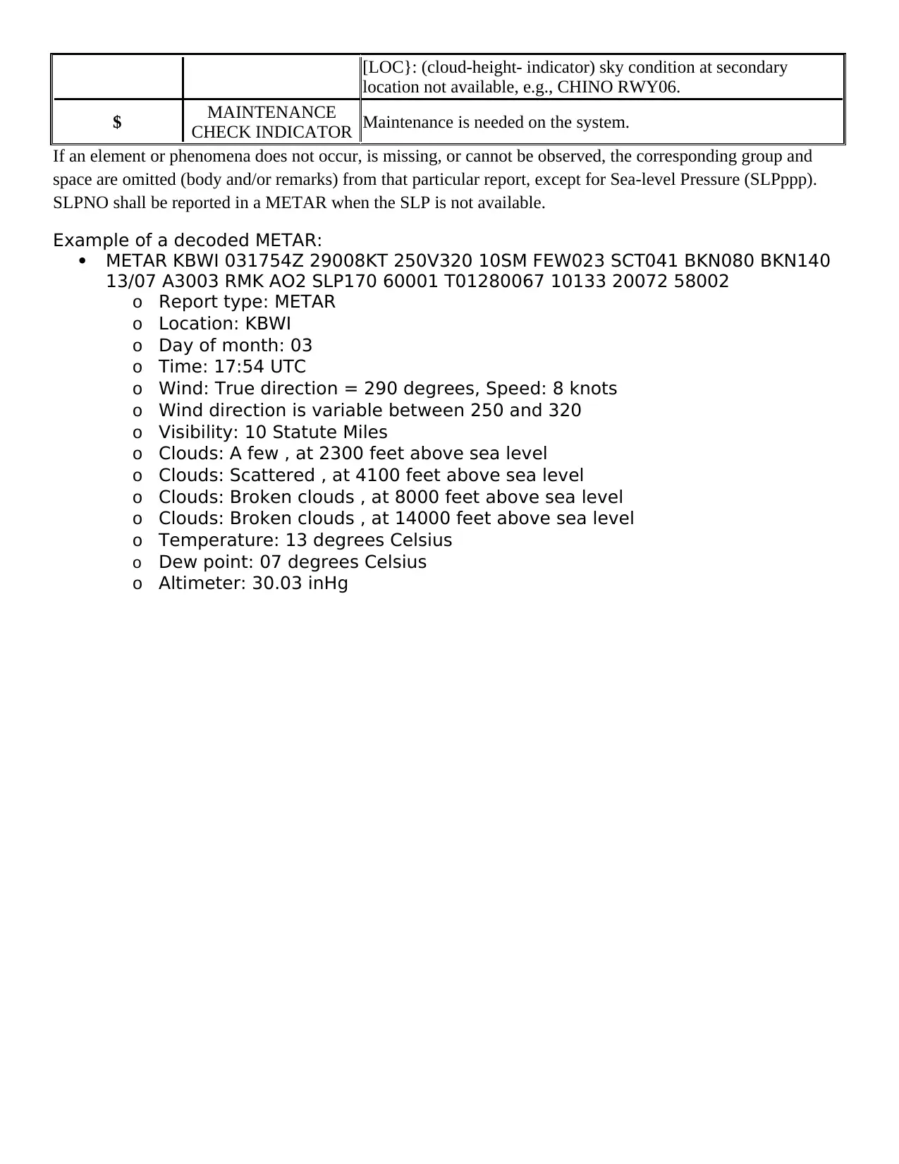
[LOC}: (cloud-height- indicator) sky condition at secondary
location not available, e.g., CHINO RWY06.
$ MAINTENANCE
CHECK INDICATOR Maintenance is needed on the system.
If an element or phenomena does not occur, is missing, or cannot be observed, the corresponding group and
space are omitted (body and/or remarks) from that particular report, except for Sea-level Pressure (SLPppp).
SLPNO shall be reported in a METAR when the SLP is not available.
Example of a decoded METAR:
METAR KBWI 031754Z 29008KT 250V320 10SM FEW023 SCT041 BKN080 BKN140
13/07 A3003 RMK AO2 SLP170 60001 T01280067 10133 20072 58002
o Report type: METAR
o Location: KBWI
o Day of month: 03
o Time: 17:54 UTC
o Wind: True direction = 290 degrees, Speed: 8 knots
o Wind direction is variable between 250 and 320
o Visibility: 10 Statute Miles
o Clouds: A few , at 2300 feet above sea level
o Clouds: Scattered , at 4100 feet above sea level
o Clouds: Broken clouds , at 8000 feet above sea level
o Clouds: Broken clouds , at 14000 feet above sea level
o Temperature: 13 degrees Celsius
o Dew point: 07 degrees Celsius
o Altimeter: 30.03 inHg
1 out of 5
Your All-in-One AI-Powered Toolkit for Academic Success.
+13062052269
info@desklib.com
Available 24*7 on WhatsApp / Email
![[object Object]](/_next/static/media/star-bottom.7253800d.svg)
Unlock your academic potential
Copyright © 2020–2026 A2Z Services. All Rights Reserved. Developed and managed by ZUCOL.