Mobile Location Systems: A Detailed Review of Technologies
VerifiedAdded on 2023/06/12
|17
|3360
|250
Literature Review
AI Summary
This literature review provides an overview of mobile location systems, detailing various technologies and procedures used to determine the position of mobile devices. It covers Global Positioning System (GPS) and its limitations, as well as A-GPS (Assisted-GPS) and S-GPS (Simultaneous-GPS) to enhance location tracing. The review discusses radio signal multi-lateration, network-based techniques (Advanced Forward Link Trilateration, Triangulation, Cell Identification), handset-based methods (client software, fingerprinting), SIM-based approaches, Wi-Fi positioning, and hybrid systems combining different technologies. It also outlines the mobile locating procedure, including collecting Location Area Code, Mobile Country Code, and Mobile Network Code, using triangulation, and analyzing Measurement Report packets to estimate the distance between the mobile phone and cell tower. The review emphasizes factors affecting accuracy, such as cell base station concentration and urbanization, and highlights challenges associated with each technique.
MOBILE LOCATION SYSTEM
Paraphrase This Document
Need a fresh take? Get an instant paraphrase of this document with our AI Paraphraser
Contents
MOBILE LOCATION SYSTEM........................................................................................5
Mobile Location System......................................................................................................5
Localization.........................................................................................................................5
Global Positioning System..........................................................................................................5
Location Tracing..........................................................................................................6
Radio signals multi-lateration in between the phone and network cell towers...........................7
Technology..................................................................................................................................7
Network Based.............................................................................................................................8
Key Factors..................................................................................................................8
Handset-Based.............................................................................................................................9
SIM-Based.................................................................................................................................10
Wi-Fi..........................................................................................................................................10
Hybrid........................................................................................................................................11
Mobile Locating Procedure................................................................................................11
CONCLUSION..................................................................................................................13
REFERENCES..................................................................................................................14
APPENDIX A – ABREVIATIONS, KEYWORDS AND AUTHORS.............................16
APPENDIX B – BOOKS AND PAPERS..........................................................................17

⊘ This is a preview!⊘
Do you want full access?
Subscribe today to unlock all pages.
Trusted by 1+ million students worldwide
MOBILE LOCATION SYSTEM
LITERATURE SURVEY
Mobile Location System
Mobile location system is a newly developed system that takes the help of the GIS to
locate the position of the mobile, in both the conditions of moving and stationary.
Localization
The concept of localizaiton of the mobile is usually done in two methods.
Global Positioning System
GPS is a GNSS (Global Navigation Satellite System), which was developed by the
Department of Defence in the US and later got fully functional, all around the globe. The system
makes use of the constellation of medium Earth Orbit satellites of 24 and 32 and transmits
precise signals of microwave[1]. The system enables the receivers of GPS for determination of
the current velocity, time and current location. The position is calculated by the GPS receiver, by
timing signals, precisely, sent by the satellites of the GPS, much above the surface of the earth
[4].
Paraphrase This Document
Need a fresh take? Get an instant paraphrase of this document with our AI Paraphraser
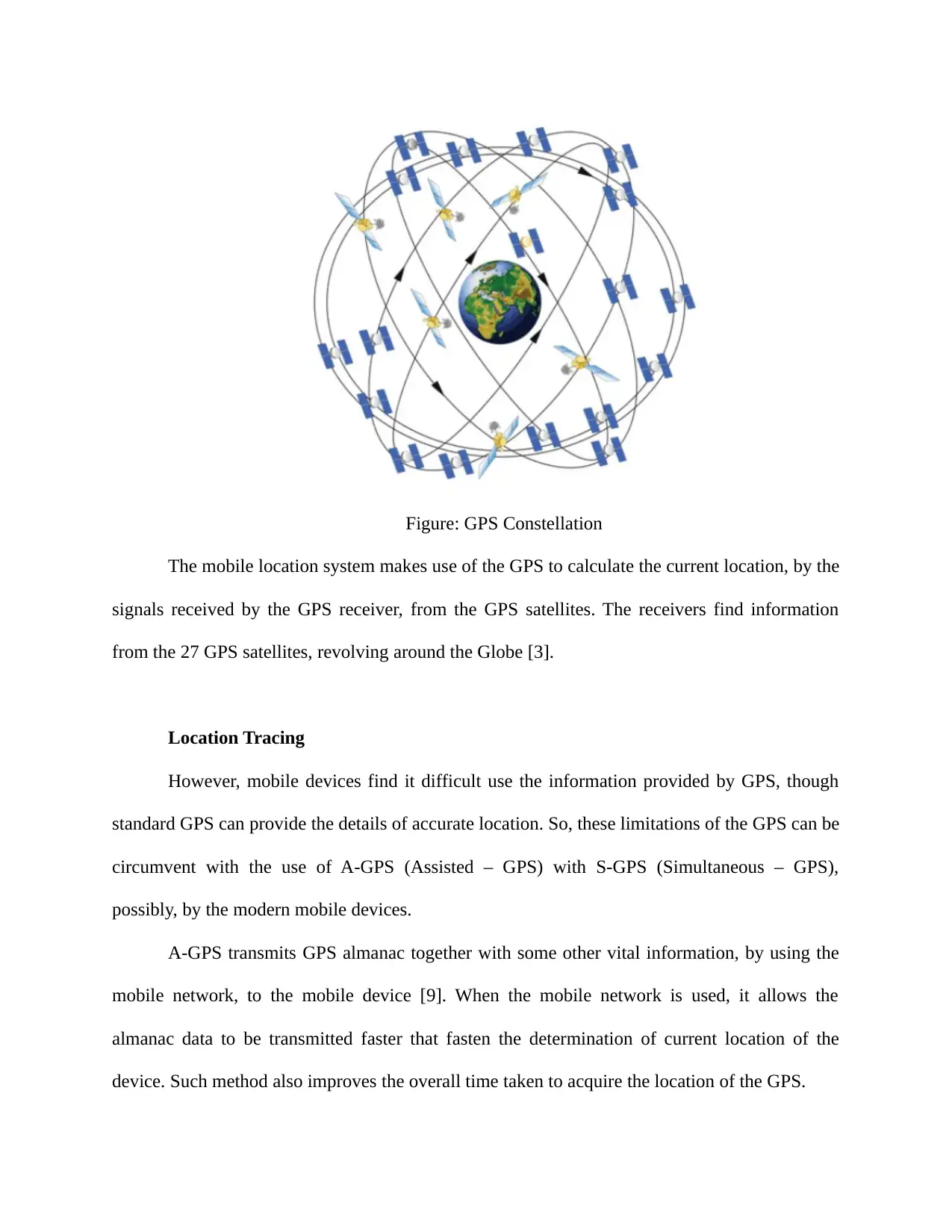
Figure: GPS Constellation
The mobile location system makes use of the GPS to calculate the current location, by the
signals received by the GPS receiver, from the GPS satellites. The receivers find information
from the 27 GPS satellites, revolving around the Globe [3].
Location Tracing
However, mobile devices find it difficult use the information provided by GPS, though
standard GPS can provide the details of accurate location. So, these limitations of the GPS can be
circumvent with the use of A-GPS (Assisted – GPS) with S-GPS (Simultaneous – GPS),
possibly, by the modern mobile devices.
A-GPS transmits GPS almanac together with some other vital information, by using the
mobile network, to the mobile device [9]. When the mobile network is used, it allows the
almanac data to be transmitted faster that fasten the determination of current location of the
device. Such method also improves the overall time taken to acquire the location of the GPS.
The Standard GPS enabled mobile devices communicate with the satellite of GPS, by
using of the same hardware and to enable phone calls. So, at one point of time, only one action
can be taken place. This issue is addressed by S-GPS by adding more hardware, allowing both
the cellular network and GPS radio network operating simultaneously [7]. When both these two
radios get active, this ability speedup the transmission of the GPS data, as receiving data is
allowed, when the radio of cellular network is active.
Radio signals multi-lateration in between the phone and network cell towers
In this process, the mobile needs to emit the roaming signal at least to contact the antenna
tower, which is nearby the phone. An active cell is not needed for this kind of process. But the
key factor is the signal strength of the phone, which is again dependent over the Global System
for Mobile Communications, to nearby antenna masts. It makes use of dedicated trackers or
GSM mobile phones, usually, to locate the user, using the mobile phones also [5].
The actual mobile phone coordinates are disclosed by the mobile positioning that include
the location based service, a telecommunication technology used by the same companies, for
approximating the mobile phone location and so its uses too.
Technology
The basis of the locating of the mobile phone is basically, on the measurement of power
levels and also the patterns of antenna. The logic behind this technology is that when the mobile
phone is in the condition of powered, it wirelessly communicates, continuously with a base
station that is closeby [6]. Hence the base station location knowledge would imply the nearby
cell phone.
There are advance systems developed and available for mobile tracking system. In this
system the exact location of the mobile system can be roughly estimated, with approximate
⊘ This is a preview!⊘
Do you want full access?
Subscribe today to unlock all pages.
Trusted by 1+ million students worldwide
distance, from the mobile phone to the base station. Then interpolation of signals is done, in
between the antenna towers that are adjacent, for further approximation. However, this distance
approximation is varied for both rural and urban areas. Close to 50 meters of precision distance
can be achieved, in the urban areas, for basically three reasons, first for comparatively higher
antenna tower density, high mobile traffic and when qualified services are considered [8].
However, it is several miles distance found in between phones and base antenna, in rural areas,
because of the contradicting features and hence, the locating results in less precision.
While this is the technology and logic in tracking the mobile location, there are different
ways and techniques used to locate the mobile phones.
Network Based
The key point here is the network infrastructure of the service provides and it helps to
locate the position of the mobile phones. This technique of network based has the advantage that
it does not affect the handsets, as it is implemented non-intrusively [10]. The technique was
developed much before the GPS widespread usage on the mobile handsets.
The network based technique performs mobile location with varied accuracy and
precision.
a. Advanced Forward Link Trilateration – This is the most advanced network based
technique based on the method of timing and is determined to be most accurate.
b. Triangulation – This technique performs the location process with moderate accuracy
of locating the handsets.
c. Cell Identification – This technique locates the position of the mobile phone with
least accuracy
Key Factors
Though there are different methods of the network-based technique, there are certain
factors that influence the accuracy and precision of the location of the mobile phones [11]. The
Paraphrase This Document
Need a fresh take? Get an instant paraphrase of this document with our AI Paraphraser
two important key factors are cell base station concentration and urban environment. The cell
base station concentration, when in higher levels allows finding the mobiles with more precision
and the same with the urbanization, because of possible more number of cell towers and current
timing methods.
Though network based technique works fine with the best methods, it has got certain challenges
that the process works much closer to the service provider, since it demands hardware and
software installation within the infrastructure of the operator.
Handset-Based
A new system of mobile location has been enhanced with the help of the installation of
specific client software on the mobile phone. The location of the mobile phone is determined by
this technique by specifying and pointing the location of the mobile through home cell and
neighbouring signal strength that is sent to the carrier, continuously, along with the cell
identification. More precise location of the mobile can be obtained, when the mobile handset has
also GPS equipped within it, to send to carrier [12].
There is also another method deployed with this technique, called fingerprinting-based
technique. The technique is employed to determine the location of the handset, in real time,
through recording signal strength, at various points, both at the home cells as well as
neighbouring cells, by war-driving and get matched. It does not need the involvement of the
carrier.
The handset-based technique has a disadvantage that it demands software installation on
the mobile handset. So, active cooperation of the software and mobile subscriber is needed so
that different operating systems can be handled in the mobile phone. Usually, such software, like
Google Maps is enabled to be run, only in the smartphones that are based on Windows Phone,
Symbian, BlackBerry OS, Android, Windows Mobile, iOS.
However, there is also a work around for the above drawback is that the software or
embedded hardware installation can be implemented by the manufacturer of the handsets, like E-
OTD (Enhanced Observed Time Difference). But, it is difficult in one way that a common
mechanism has to be convinced by different manufacturers and issue of cost is another challenge.
Yet another challenge would be the foreign handsets that become part of the network in roaming
mode.
SIM-Based
The technique uses the logic that the raw radio measurements can be obtained from the
handsets, through using SIM (Subscriber Identity Module) in mobile handsets of UMTS
(Universal Mobile Telecommunication System) and GSM. Signal strength, round-trip time and
serving cell ID are the available measurements for the same [13]. The available information from
the handset is different from that of the SIM, like measurements can be taken from the SIM,but
not from the handset.
Wi-Fi
The mobile location can be tracked and identified through crowdsourced Wi-Fi data. New
methods of carrying the indoor positioning on the basis of Wi-Fi are designed because of the
gradually increasing Wi-Fi popularity and GPS based method’s poor performance. Eventually,
most of the smartphones have been designed with the combination of GPS, GLONASS and GPS
and other Global Navigation Satellite Systems with Wi-Fi positing systems.
⊘ This is a preview!⊘
Do you want full access?
Subscribe today to unlock all pages.
Trusted by 1+ million students worldwide
Hybrid
The hybrid positioning system makes use of the hand-set based and network-based
technologies, for the determination of location. For example, Assisted GPS modes that make use
of the network and GPS information can be used for location computation. This combined data
helps to find more accurate location, when the telephone is used [18]. Both the systems are also
used as an alternate tracking system, occurring through GPS location attained directly by the
mobile phone, from the satellites and sending the information to the person through the network
to locate the position. These systems, for instance, are, LTE’s OTDOA, Google Maps and E-
CellID.
Some of the hybrid positioning systems make use of various approaches of location, in
combination, to locate the mobile position, through GSM, IP address, WiMAX, network
environment data and Wi-Fi.
Mobile Locating Procedure
1. Initially, the IMEI or phone number of the user is noted and then the respective Location
Area Code, Mobile Country Code and Mobile Country Code are collected from the
service provider. This information is used to find the cell tower location, nearby the SIM
which is installed in the mobile, which is being tracked.
2. Usually, 3 to 4 cell tower information is obtained, for more precise location.
3. Then triangular method is used for the location calculation. Triangulation is an essential
process of knowing the location of the mobile. The process involves drawing of three arcs
or circles, so that a common point cna be obtained. GPS also conducts the location
system, in the similar ways.
Paraphrase This Document
Need a fresh take? Get an instant paraphrase of this document with our AI Paraphraser
4. Usually, the mobile devices have to readjust to the path of receiving the radio signals,
according to the distance of it, from the cell tower. Propagation delay is proportional to
the distance. So, the feedback si sent continuously by the device, about the distance of it.
Accordingly the transmitting tower also makes readjustments about lag or lead of the
Wireless or Radio frequency signal, according to the feedback of the device [15]. So, the
information about the distance is sent continuously by the mobile, a Measurement Report
packet towards the network or cell tower.
5. According to the equipment of the network vendor, it enables special traces so that IMEI
(Mobile Device Serial Number) or IMSI (Mobile Subscriber Number) related
Measurement Reports can be captured.
6. These measurement reports are usually read and decoded by the Network Engineers, with
some special software tools, like M2000, Omstar, Nastar, etc.
7. Then the distance in between the mobile phone and cell tower is obtained, with the
values, given for example, below,
a. 2G – Timing Advance = 0 (ranges from 0 to 550 meters)
= 1 ( 550 to 1100m)
= 2 (1100 to 1650m)
=3 (1650 to 2200m) and so on
b. 3G – Propagation Delay or TP = 234M
= 0 (ranges from 0 to 234m)
= 1 (234 to 468m)
= 2 (468 to 672m) and so on
c. 4G – Timing Advance = 78 meters
= 0 (0 to 78m)
= 1 (78 to 156m)
= 2 (156 to 234) and so on
As the technology gets progressing, the unit of the distance becomes smaller and smaller,
finding more accurate information about the location to find.
Since only a single cell gets connected with the mobile device, in 2G, the process of
triangulation becomes difficult and eventually, range becomes large. However, it is technically
possible by a detailed Measurement Report analysis, like finding more values of TA for intense
process of triangulation, at the cases of handing over the signal from one cell to another cell.
However, this process of triangulation becomes easier, when the device is enabled with
3G or 4G, especially, when there are multiple serving cells are involved for call or connection
session. Hence, it is known as PCI for 4G and Active Set for 3G [16].
An expert RF engineer can better read the measurement reports that have other values of
the Radio Frequency signals and analyze the location profile of the mobile device, like Receive
Signal Quality, Receive Signal Level, Transmit Power of Mobile Device, etc.
CONCLUSION
Mobile Location System has been a prominent application, preferred by many users and
hence the technology has been progressing accordingly to search and find the location of the
mobile, through the technology. Such system becomes potential and viable, when the service
provider, mobile handset designer & developer and satellite communication like GPS collaborate
among them, to offer and provide the best technology and method for Mobile Location System.
⊘ This is a preview!⊘
Do you want full access?
Subscribe today to unlock all pages.
Trusted by 1+ million students worldwide
1 out of 17
Related Documents


Your All-in-One AI-Powered Toolkit for Academic Success.
+13062052269
info@desklib.com
Available 24*7 on WhatsApp / Email
![[object Object]](/_next/static/media/star-bottom.7253800d.svg)
Unlock your academic potential
Copyright © 2020–2026 A2Z Services. All Rights Reserved. Developed and managed by ZUCOL.