Surface Runoff Impact: Greenfield Land Development in New South Wales
VerifiedAdded on 2023/06/11
|13
|3830
|157
Report
AI Summary
This report examines the impact of surface runoff on a proposed greenfield land development in New South Wales, Australia. It begins by defining surface runoff and discussing the factors influencing its generation, including rainfall intensity and duration, soil type, vegetation cover, slope, and catchment size. The report then focuses on a specific project involving the development of a 3.307 square kilometer greenfield site, highlighting the relevant council regulations and the importance of adhering to planning management strategies. It emphasizes the need to comply with the Blue Mountains local environment plan and development control plans to ensure sustainable land management, maintain ecological balance, and mitigate potential flood risks. The report also discusses the significance of obtaining a section 149 planning certificate, which provides crucial information regarding land use, zoning, heritage, and flood management, to inform responsible development decisions and protect local communities from runoff-related hazards. Desklib provides students access to similar assignments.

Course:
Course Code:
Name of student:
Institutional Affiliations:
Name of the professor:
Course Code:
Name of student:
Institutional Affiliations:
Name of the professor:
Paraphrase This Document
Need a fresh take? Get an instant paraphrase of this document with our AI Paraphraser
Introduction
Over the recent past, there has been an increase in the quantity of paved surface all over the
world. Paved surfaces have been majorly influenced by developments that are centered on
human inhabitation. Population increase is therefore the major factor that has led to an increase
in the quality of surface runoff (Norbiato, 2009). The increase in impermeable land and a
consequent decrease in natural ground leads to an increase in the amount of water that is
transported over land and decreases the rate of infiltration (Meyles, 2003). Therefore, surface
runoff may be described as the excess water that flows over the earth’s surface after a prolonged
rainfall (Huang & Tu, 2012). The runoff generally flows over the land surface and may create
channels that only disappear at a discharge point or at a location where the surface runoff does
not have sufficient energy to flow.
There are a number of stages that are involved in the formation of surface runoff. However, these
factors may be limited to some regions more than others and as such, it is important for the
hydrologist to establish the type of land prior to making any conclusions. To begin with, runoffs
are only created during a prolonged rainfall event (Rodriguez-blanco & M, 2012). When it
begins raining, the first drops of rain usually fall on the surface of the leaves as well as the stems
and other parts of vegetation. Therefore, these drops do not reach the ground surface but are
retained on the plants. It is usually the first stage in any rainfall event and is known as the
retention stage (Scherrer, 2007). The second stage comes after a prolonged rainfall event
whereby the amount of water that infiltrates into the soil exceeds the capacity of infiltration.
When the infiltration capacity of the soil is overcome by continuous rainfall, the excess water
tends to form puddles. Soils have different infiltration capacities but all this depends on texture.
Furthermore, this may also depend on the initial moisture content of the soil whereby soils that
have higher moisture content tend to have a lower infiltration capacity while the vice versa is
also true.Therefore,a land surface will continue to generate runoff as long as the infiltration
capacity is exceeded by the rainfall (Latron, 2008). When the infiltration capacity exceeds the
rainfall amount, the amount of water that may be transported as runoff decreases.
Surface runoff may either flow to a natural water stream or body or may move downslope to a
water treatment facility (Merz & Blöschl, 2006). However, this is more prevalent in urban
centers where there are sewer systems that are used for the transportation of wastewater. The two

most common sewer types in urban settings are the combined and separate sewer systems (Sun,
2015). The two systems may be used for the transportation of storm runoff to a treatment facility
or a water body. However, the combined system combines both the wastewater from households
with the runoff while the separate system has two channels the first one transporting wastewater
while the second transporting the runoff (FEMA, 2016).
The runoff from a particular location depends on a number of factors. Regardless, the rainfall
duration and intensity are the most fundamental factors that determine the amount and rate of
runoff (Penna, 2011). To begin with, the runoff depends on the type of soil. The arrangement of
the particles determines how the water flows into the deeper layers and the resistance to
infiltration (Scherrer, 2007). Furthermore, the arrangement of particles usually determines the
water storage and retention capacity of the soil and therefore plays a fundamental role in the
generation of surface runoff. The arrangement of the particles in sandy soils allows the
infiltration to be much more than that of other compact soils such as clay. Therefore the runoff in
clay soil is likely to be more than that of sandy soil after exposure to the same rainfall intensity
as well as duration.
There is the likelihood that rainstorms are much more likely to lead to runoffs than the normal
rains regardless of the type of soil. With an increase in the rainfall there is an increase in the
energy that the drops possess which result into finer soil particles rising to the top layers and
clogging the pores (Endale, et al., 2006). Clogging of the pores results to a decrease in the
infiltration capacity of the soils which means that there is an increase in the amount of runoff
generated after a light storm. The phenomenon can easily be observed in arid and semi-arid lands
where there are frequent rainstorms and runoffs. The runoffs are common regardless of the
rainfall duration because of the clogging of the pores.
Secondly, the runoff depends on the vegetation that is available. Interception of rainfall depends
on the type of vegetation as well as its growth stage. The interception storage depends on the
type of crop with particular concern on the size of foliage (Donker, 2001). The values used to
determine the interception storage vary between 1 and 4 (Blume, et al., 2007).Furthermore, the
amount of vegetation over a particular land surface reduces the amount of rainfall reaching the
soil surface and therefore limits the amount of water that may be available for infiltration.
Foliage also limits the amount of raindrops reaching the soil surface and as such limits the
⊘ This is a preview!⊘
Do you want full access?
Subscribe today to unlock all pages.
Trusted by 1+ million students worldwide

energy that may be used to crumble the soil particles. The inability of the raindrops to crumble
the soil particles and clog the pores is a limitation to the amount of runoff that may be generated
from a particular surface.
Finally, runoff is affected by the type of slope as well as the size of the catchment. To begin
with, there is an increase in the amount of runoff with the increase in the slope. Furthermore, the
length of the slope also determines the amount of runoff that may be generated. Runoff increases
with a decrease in the length of the slope (Balram & Megh , 2016). Considering the size of the
catchment, an increase in the size means that there is lesser time required for concentration but
the runoff efficiency tends to be lower. The runoff efficiency is the unit of measurement of the
concentration of runoff per unit time and tends to be more when the size of the catchment is
smaller (García-Ruíz, 2008). The runoff may be measured using empirical or graphical method.
Methods such as unit hydrographs, the SCS-CN models require the proper estimation of the
rainfall as well as the duration in determining runoff.
The aforementioned are some of the factors that affect the runoff that is generated from a
particular area. However, there are various graphical as well as mathematical models that are
used in the estimation of the surface runoff and they play a fundamental role in project
development. Prior to implementing a new development project, it is wise to consider the amount
of runoff that was generated on the undeveloped land and the amount that will be generated after
the land has been developed. Estimating the new amount of runoff will be useful in the design
and construction of drainage channels as well as the upgrade of the current discharge channels.
Paraphrase This Document
Need a fresh take? Get an instant paraphrase of this document with our AI Paraphraser
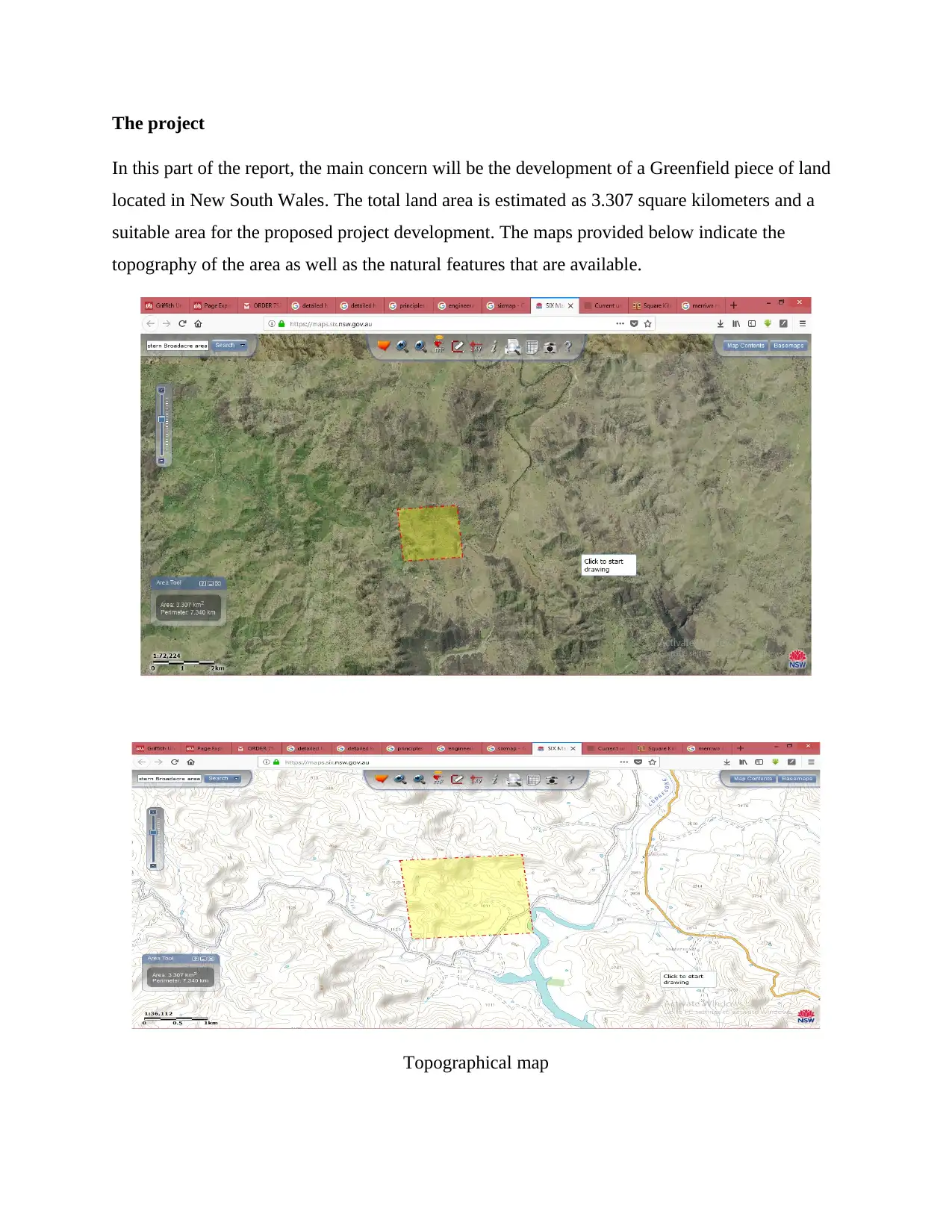
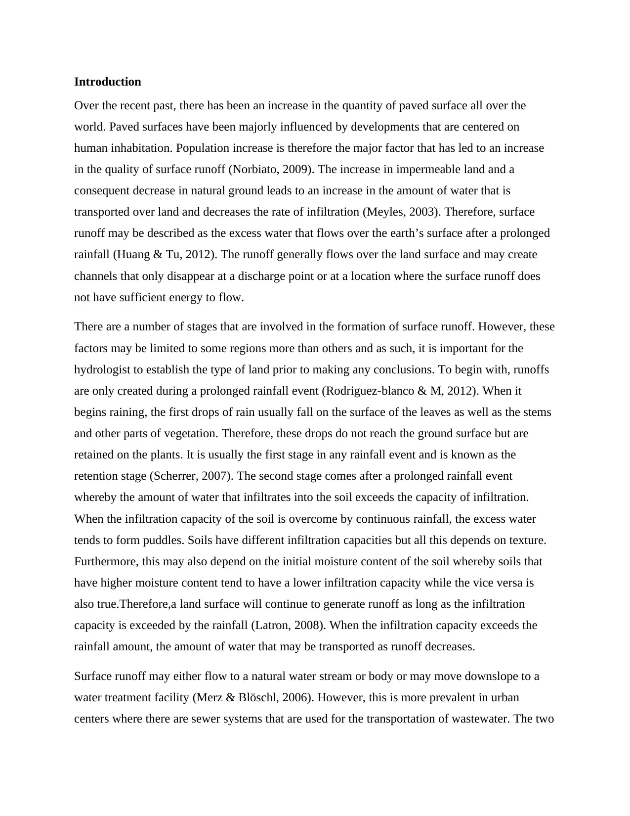
The project
In this part of the report, the main concern will be the development of a Greenfield piece of land
located in New South Wales. The total land area is estimated as 3.307 square kilometers and a
suitable area for the proposed project development. The maps provided below indicate the
topography of the area as well as the natural features that are available.
Topographical map

Regarding the development of the region, there are numerous council regulations that determine
the viability of the developments as well the ecology of the region. Therefore, prior to
implementing the development plans, the project manager and the various stakeholders will need
to abide by the regulations that are outlined. However, the New South Wales council has
mandated every resident with the responsibility of ensuring that all the areas are properly
managed. It is especially useful to the residents from areas that are flood prone and this is
properly managed by ensuring that there is exchange of information between the members of the
council and the residents (Blue Mountains City Council, 2017).
One of the aspects of development in the area is the exempt development projects. The projects
are minor and do not require the approval of the council if all the outlined standards are adhered
to. Some of these projects include minor renovations and small construction projects. Secondly,
there is the complying development. Complying development focuses on projects such as
residential, commercial and other major development projects. Considering that these are big
projects whose development may increase the flooding of the area, the council or an approved
certifier may approve or decline the development project. There are two areas that may be
considered in the approval process, the flood prone lot as well as the safe land areas. However, it
is the responsibility of a hydraulic engineer to approve the flood prone lots that may be
developed. As such, the housing act indicates that there should be no development in flood prone
areas that are to be approved by the council.
With the approval of the land area, the next step is to obtain a section 149 planning certificate
(lithgow City council, n.d.). The certificate is issued to every NSW resident and is issued to an
individual upon purchase of a property or the construction of the same. The certificate should be
available even when the property is on sale. It is the mandate of the customer to ensure that the
seller has these certificates in order when purchasing the property. However, this is as per the
local council under New South Wales.Generally,there are two types of these certificates that may
be issued when the council observes that all the requirements have been fulfilled. The first one is
the S149-2 certificate while the second is the S149-5 certificate. The first document provides a
detailed description of the total land area with factors such as heritage, conservation, the land
use, the zoning, heritage of the land, road widening and the flood management and control
programs of the land to be acquired, On the other hand, the second document provides all the
⊘ This is a preview!⊘
Do you want full access?
Subscribe today to unlock all pages.
Trusted by 1+ million students worldwide

aforementioned information but has additional information regarding the land that may be at the
disposal of the council. The document gives all the necessary advice regarding the development
of the land.
Considering the development of the land, the certificates will be an important source of
information regarding the run off, flooding and the damage that is likely to occur in case of a
rainfall event. It is the mandate of the New South Wales government together with the blue
mountain council to ensure that the locals are protected from runoff events which are likely to
bring about floods and as such, it will be important to comply with all the project and
government requirements.
As with the Blue Mountains local council, it is imperative that the development plan observes all
the policies and planning management strategies that have been drafted. However, it is important
to understand that developments around this region are controlled by the Blue Mountains local
environment plan alongside other development control plans. Though the two may be singly
managed and controlled, it is imperative to understand that the former is in charge of land
management whereby it provides a platform through which the various development plans can
be managed while the latter forms the regulatory body. The development control plans ensure
that the proper guidelines are adhered to and as such provide a platform through which the land
can be managed in an effective and proper manner, maintaining the ecology and biodiversity.
The Blue Mountains local environment plan has been used since 2016 and is based on the
department of environment’s and flooding clauses. Integration of the two aspects provides an
easy way through which, in the case of a flood event, the evacuation process will be easy and the
damage will not be so severe. Furthermore, the methodology provided ensures that there are
enough facilities that may cater for the needs of the affected when there is a case of flooding.
However, this is the land that is located within areas likely to be affected by the probable
maximum flood (Sterrn, 2009).
The hyetographs and flood hydrographs (Ori, 2017) are used in the estimation of the amount of
flood to be expected in an area and therefore ensures that there is a framework that is put in place
to ensure that the effects are mildly felt. Furthermore, the council has considered a development
plan that is aimed at controlling and managing the type of developments that are to be initiated
and managed in the locality. The plan was developed in order to ensure that there is controlled
Paraphrase This Document
Need a fresh take? Get an instant paraphrase of this document with our AI Paraphraser

development and there are guidelines and controls that manage the eventual development of the
land.
All these are factors that will need to be considered in the development of the land and will play
a fundamental role in limiting the flooding as well as the runoffs that may be deemed destructive
to the eventual development of the land and locality.
Therefore, it is important for the project manage to be well equipped with the necessary
knowledge surrounding the development of a locality as well as the necessary requirements of
the council. The runoff to be generated is determined through mathematical modelling and
analysis (Satheeshkuma, et al., 2017) which in turn helps the developer and the other concerned
members understand the factors likely to increase the runoffs as well as the effects of runoffs on
the locality.
Detailed Analysis (using the rational method)
Before the actual development
Working from this perspective, a number of assumptions will have to be considered.
The area is relatively flat with the slope having a rise of 16 meters for every 50 km
Before the actual development, the area is relatively natural and as such, the runoff coefficient is
between 0.05 and 0.35.
The runoff coefficient=0.2
Runoff coefficients using the rational method (Chin, 2000)

The total land area is 3.307km2
Calculating the time of concentration: time required for a drop of water at the most remote part
of the watershed to reach a discharge point.
A is the area of the watershed.Thereforere, the time required is 1.088 seconds before and after
development.
The discharge/runoff expected =
A is the area
C is the coefficient of runoff
I is the intensity. It is usually obtained from the intensity duration frequency curves of the region.
In this analysis, it will be assumed as 50mm/hr.
Q=0.278X0.2X50X3.307= .This is the discharge expected from the watershed
before the actual development.
After development
Concrete surfaces have a runoff coefficient=0.7-0.95
Taking a runoff coefficient of 0.8
The total area =3.307km2
The time of concentration=
The time of concentration=1.088seconds
The discharge/surface runoff expected after development=
Discharge after development=0.278X0.8X50X3.307=
There are other simpler methods that may be used in the analysis of the rainfall runoff
relationship.
⊘ This is a preview!⊘
Do you want full access?
Subscribe today to unlock all pages.
Trusted by 1+ million students worldwide

Simpler analysis
These analysis consider the percentage of rainwater transported as runoff
Grassy surface=60%
Hard surfaces=100%
Working from an average volume of 200mm annually.
Dividing the total area into 3, a single area=1.102km2
Before development and assuming a permeability of 50%
The total runoff from a single area=0.0002X1.102=220400000 cubic millimeters X
50/100(permeability) =11020000 cubic millimeters
After development and assuming a permeability of 0% where the total land area is covered in
concrete (Extreme).
The total runoff from a single area=0.0002X1.102=220400000 cubic millimeters
Recommendation
One of the recommendation so that the agencies accept the proposal is a decrease in the paved
area. This will be done by increasing the natural ground cover through lawns and yards.
Furthermore, use of permeable concrete pavements will decrease the discharge from the
development site. The main aim is to decrease the amount of discharge by increasing the
infiltration.
Use of permeable pavement structures has been tested and is a reliable method of increasing the
infiltration to the ground. Increase in infiltration reduces the discharge from a surface as well as
surface runoff. On the other hand reducing the amount of concrete surface on the site will
increase the inflow of rain water to the ground through infiltration.
Paraphrase This Document
Need a fresh take? Get an instant paraphrase of this document with our AI Paraphraser

CONCLUSION
It is important to consider the effects of development on a Greenfield area prior to the actual
development.Increasee in the amount of impervious surfaces leads to an increase in the amount
of runoff which may consequently mean an increase in the rate of flooding at a particular region.
However land use and land cover change are not the only factors that tend to determine the rate
of runoff from a particular region. The most important inherent determinates on the rate of runoff
from a particular Greenfield area are the soil characteristics. Soil characteristics such as particle
arrangement and the pore sizes determine the rate at which runoff may be generated from a
particular region.
Regardless, the most convenient and widely used method in the calculation of runoff is the SCS-
CN model. The model focuses on the empirical relationship between losses from storage as well
as infiltration to determine the water available to be transported as runoff. Other methods which
require lesser data are available but the accuracy is less than that of the aforementioned method.
Considering that developments tend to increase the amount of runoff from a location, there has
been numerous planning and development policies that have been proposed and enacted to
control the amount as well as the type of structures developments. These laws are enacted and
outlined by the government as well as the local council. Moreover, some of these laws are aimed
at maintaining a certain proportion of the natural ground and as such ensure the biodiversity as
well as the ecology of the region is maintained.
\
References
Balram, P. & Megh , G. R., 2016. Soil and Water Engineering: Principles and Applications of Modeling.
s.l.:s.n.
Blue Mountains City Council, 2017. Draft floodplain risk management and study plan. s.l.:s.n.
Blume, T., Zehe, E. & Bronstert, A., 2007. Rainfall runoff response, event-based runoff coefficients and
hydrograph separation. Hydrological sciences Journal.
Chin, D. A., 2000. Water-Resources Engineering. s.l.:s.n.
Donker, N. H., 2001. A simple rainfall–runoff model based on hydrological units applied to the Teba
catchment (south east Spain).‐ s.l.:s.n.
Endale, D. M., Fisher, D. S. & Steiner, J. L., 2006. Hydrology of a zero-order southern Piedmont
watershed through 45 years of changing agricultural land use. Part 1. Monthly and seasonal rainfall–
runoff relationships.. journal of Hydrology.
FEMA, 2016. Guidance for Flood Risk analysis and Mapping. s.l.:s.n.
García-Ruíz, J. M., 2008. Flood generation and sediment transport in experimental catchments affected
by land use changes in the central Pyrenees. journal Of Hydrology.
Huang, J. & Tu, Z., 2012. Analysis of rainfall runoff characteristics from a subtropical urban lawn
catchment in South-east China. Frontiers of environmental science and engineering.
Latron, J., 2008. Spatial and temporal variability of the hydrological response in a small Mediterranean
research catchment (Vallcebre, eastern Pyrenees). hydrological processes.
lithgow City council, n.d. lithgow floodplain management. [Online]
Available at: https://council.lithgow.com/lithgow-floodplain-management/
Merz, R. & Blöschl, G., 2006. patio-temporal variability of event runoff coefficients.. journal of
Hydrology.
Meyles, E., 2003. Runoff generation in relation to soil moisture patterns in a small Dartmoor catchment,
Southwest England.. hydrological Processes.
Norbiato, D., 2009. Controls on event runoff coefficients in the eastern Italian Alps. Journal of
Hydrology.
Ori, j., 2017. How to Calculate Surface Runoff. [Online]
Available at: https://sciencing.com/calculate-surface-runoff-6505227.html
[Accessed 2018].
Penna, D., 2011. Controls on event runoff coefficients in the eastern Italian Alps. Hydrology and Earth
System Sciences.
Rodriguez-blanco, L. & M, T.-c. M., 2012. Rainfall–runoff response and event-based runoff coefficients in
a humid area (northwest Spain). hydrological science journal.
⊘ This is a preview!⊘
Do you want full access?
Subscribe today to unlock all pages.
Trusted by 1+ million students worldwide
1 out of 13


Your All-in-One AI-Powered Toolkit for Academic Success.
+13062052269
info@desklib.com
Available 24*7 on WhatsApp / Email
![[object Object]](/_next/static/media/star-bottom.7253800d.svg)
Unlock your academic potential
Copyright © 2020–2026 A2Z Services. All Rights Reserved. Developed and managed by ZUCOL.