Total Station in NSW Rail Infrastructure: An Engineering Survey Report
VerifiedAdded on 2023/06/12
|9
|1920
|285
Report
AI Summary
This report discusses the application of total stations in the New South Wales (NSW) rail infrastructure for precise measurement of vertical and horizontal alignments. It highlights the importance of accurate surveying in railway engineering for functional, safe, and efficient rail networks. The report details the equipment used, focusing on robotic total stations and their benefits, including faster layouts, improved accuracy, and reduced errors. It explains the operation, calibration, and maintenance of total stations, including regular checks, software upgrades, and environmental protection. The report also covers specifications such as tolerances and datum, adherence to NSW Surveyor General’s Directions and other regulations, and compliance with standards like T HR TR 13000 ST and ISO 17123-3. Furthermore, the report elaborates on data management, including automated data capture, computational processing, and various presentation formats, ensuring quality control through built-in computers and regular maintenance. This document is available on Desklib, a platform offering a wide range of study tools and solved assignments for students.

Engineering Survey 1
ENGINEERING SURVEYING
Name
Course
Professor
University
City/state
Date
ENGINEERING SURVEYING
Name
Course
Professor
University
City/state
Date
Paraphrase This Document
Need a fresh take? Get an instant paraphrase of this document with our AI Paraphraser
Engineering Survey 2
Engineering Surveying
INTRODUCTION
Engineering surveying is a division of surveying profession that deals with the planning
and execution of survey works for determining suitable location, designing, constructing,
operating and maintaining various engineering projects. This project involved application of a
subdivision of engineering surveying called railway engineering. This branch of engineering
surveying deals with the definition and management of spatial information in a rail network in
connection with the vertical and horizontal alignment of the railway track, relationship of the
alignment with adjacent alignments and other civil structures, such as overhead wiring structures
and platforms. This essay report discusses one of the surveying equipment that are used in New
South Wales (NSW) rail infrastructure. The instrument discussed is total station. This is one of
the most advanced and innovative equipment in engineering survey [1].
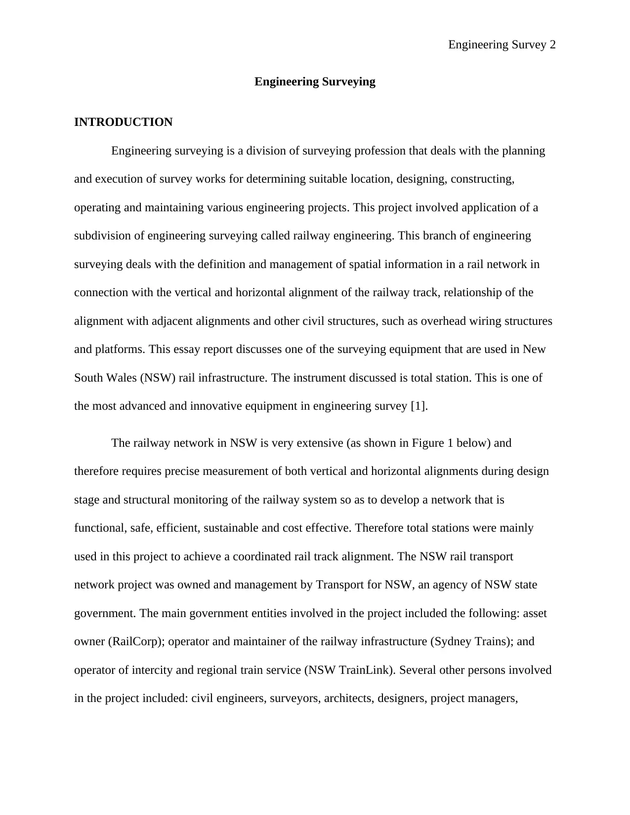
The railway network in NSW is very extensive (as shown in Figure 1 below) and
therefore requires precise measurement of both vertical and horizontal alignments during design
stage and structural monitoring of the railway system so as to develop a network that is
functional, safe, efficient, sustainable and cost effective. Therefore total stations were mainly
used in this project to achieve a coordinated rail track alignment. The NSW rail transport
network project was owned and management by Transport for NSW, an agency of NSW state
government. The main government entities involved in the project included the following: asset
owner (RailCorp); operator and maintainer of the railway infrastructure (Sydney Trains); and
operator of intercity and regional train service (NSW TrainLink). Several other persons involved
in the project included: civil engineers, surveyors, architects, designers, project managers,
Engineering Surveying
INTRODUCTION
Engineering surveying is a division of surveying profession that deals with the planning
and execution of survey works for determining suitable location, designing, constructing,
operating and maintaining various engineering projects. This project involved application of a
subdivision of engineering surveying called railway engineering. This branch of engineering
surveying deals with the definition and management of spatial information in a rail network in
connection with the vertical and horizontal alignment of the railway track, relationship of the
alignment with adjacent alignments and other civil structures, such as overhead wiring structures
and platforms. This essay report discusses one of the surveying equipment that are used in New
South Wales (NSW) rail infrastructure. The instrument discussed is total station. This is one of
the most advanced and innovative equipment in engineering survey [1].
The railway network in NSW is very extensive (as shown in Figure 1 below) and
therefore requires precise measurement of both vertical and horizontal alignments during design
stage and structural monitoring of the railway system so as to develop a network that is
functional, safe, efficient, sustainable and cost effective. Therefore total stations were mainly
used in this project to achieve a coordinated rail track alignment. The NSW rail transport
network project was owned and management by Transport for NSW, an agency of NSW state
government. The main government entities involved in the project included the following: asset
owner (RailCorp); operator and maintainer of the railway infrastructure (Sydney Trains); and
operator of intercity and regional train service (NSW TrainLink). Several other persons involved
in the project included: civil engineers, surveyors, architects, designers, project managers,
Engineering Survey 3
construction specialists, contractors, transport stakeholders, interest groups and local community.
This project was aimed at facilitating easy movement and goods to and from NSW.
Figure 1: Railway network in NSW
EQUIPMENT USED
As stated before, the equipment selected for this project report is robotic total station.
This instrument is used to collect a wide range of data on the rail infrastructure, including:
location of the rail, vertical profile of the rail, gauge elevation and super elevation. Some of the
benefits that the equipment offered in this project include: more accurate and faster layouts, more
accurate and faster quality checks, greater accuracy, reduced rework and errors, more inspection
points, data accessibility in real-time, more efficient communication between field and office
personnel, less manpower, faster completion, greater productivity and improved handover [2].
⊘ This is a preview!⊘
Do you want full access?
Subscribe today to unlock all pages.
Trusted by 1+ million students worldwide
Engineering Survey 4
Operation
Total stations are very delicate instruments and they should be handled with great care
during packaging, transportation, mounting and operation. The main processes of setting up a
total station are: centering, level and removing parallax error. The robotic total stations were
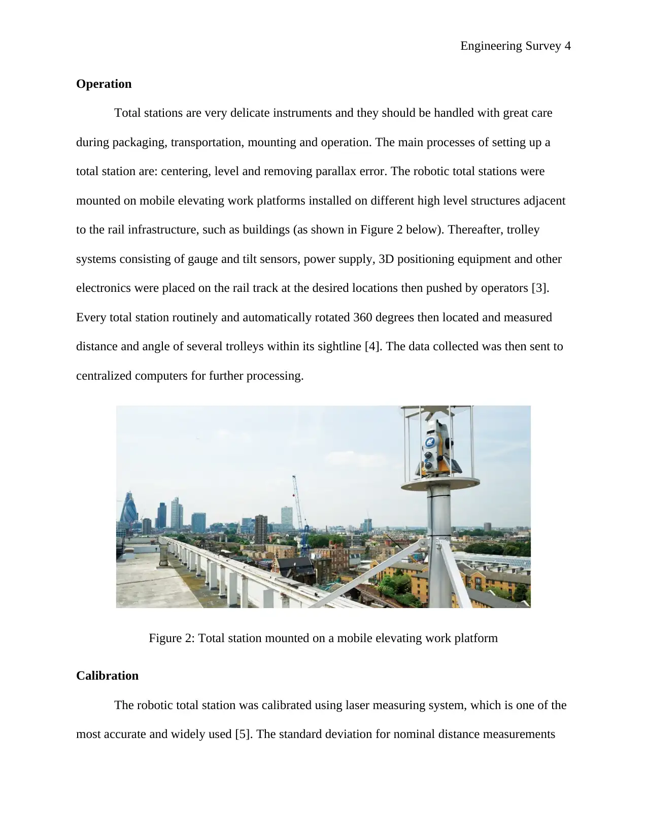
mounted on mobile elevating work platforms installed on different high level structures adjacent
to the rail infrastructure, such as buildings (as shown in Figure 2 below). Thereafter, trolley
systems consisting of gauge and tilt sensors, power supply, 3D positioning equipment and other
electronics were placed on the rail track at the desired locations then pushed by operators [3].
Every total station routinely and automatically rotated 360 degrees then located and measured
distance and angle of several trolleys within its sightline [4]. The data collected was then sent to
centralized computers for further processing.
Figure 2: Total station mounted on a mobile elevating work platform
Calibration
The robotic total station was calibrated using laser measuring system, which is one of the
most accurate and widely used [5]. The standard deviation for nominal distance measurements
Operation
Total stations are very delicate instruments and they should be handled with great care
during packaging, transportation, mounting and operation. The main processes of setting up a
total station are: centering, level and removing parallax error. The robotic total stations were
mounted on mobile elevating work platforms installed on different high level structures adjacent
to the rail infrastructure, such as buildings (as shown in Figure 2 below). Thereafter, trolley
systems consisting of gauge and tilt sensors, power supply, 3D positioning equipment and other
electronics were placed on the rail track at the desired locations then pushed by operators [3].
Every total station routinely and automatically rotated 360 degrees then located and measured
distance and angle of several trolleys within its sightline [4]. The data collected was then sent to
centralized computers for further processing.
Figure 2: Total station mounted on a mobile elevating work platform
Calibration
The robotic total station was calibrated using laser measuring system, which is one of the
most accurate and widely used [5]. The standard deviation for nominal distance measurements
Paraphrase This Document
Need a fresh take? Get an instant paraphrase of this document with our AI Paraphraser
Engineering Survey 5
was ±2 mm ±2 ppm with a standard deviation in the direction of ±1 arc second. The deviation
was the same for measurements that used S designation.
Maintenance
The total stations were maintained through regular checks by a trained and certified
technician. These instruments were serviced quarterly. Other maintenance activities included:
regular calibration (after every two weeks); checking them regularly against control points (after
every two weeks); frequent software upgrade (quarterly); routinely checking the battery and
working conditions of other components; troubleshooting, frequent cleaning with water and
soap; looking at any problem warning signs; and checking the job site conditions [6]. Each total
station had a robust body and was encased inside a wire mesh to protect it against external
conditions such as strong winds, birds and rain [7].
SPECIFICATIONS
Tolerances
Tolerance setting on the total station enables the operator to adjust tolerances so as to
achieve the desired accuracy level. The following are the tolerances of the total stations used:
horizontal angle tolerance – 0°00'20" (20 seconds), vertical angle tolerance – 0°00'20" (20
seconds), electronic distance measurement (EDM) tolerance – 1mm, and stakeout tolerance – 0.2
ft. Each measurement recorded had a standard deviation that did not exceed its tolerance.
Datum
Datum is basically the sense of horizontal or vertical reference system of the total station.
It is from this datum that all measurements taken from the total station are referenced [8]. Each
total station had a specific datum. Therefore the datum for each total station was obtained on site.
Engineering Survey 6
Horizontal datum of a total station is localized as a planar by use of ellipsoid models whereas
vertical datum uses optometric datum [9].
Legislation
The engineering surveying was undertaken under the following legislations: NSW
Surveyor General’s Directions, Surveying and Spatial Information Act 2002 No 83, and
Surveying and Spatial Information Regulation 2012.
Regulations
Procurement of robotic total stations was done by following the recommended
procedures by the NSW state government. One of the procurement regulations was that the
equipment had to be purchased from certified manufacturers. Data collected by the total stations
was analyzed by trained and qualified surveyors and engineers. The final survey reports also had
to be shared with relevant government authorities for approving the project.
Standards
The main standards applied in surveying work of this project included: T HR TR 13000
ST (Railway Surveying Standard), which was developed in 2016 and replaced the following
manual and two specifications: TMC 212 (Survey), SPC 211 (Survey) and SPC 212 (Contract
Survey), and ESC 210 (Track Geometry and Stability). Other international standards used
included: ISO 17123-3 Optics and optical instruments, Part 3 and ISO 17123-4 Optics and
optical, Part 4.
⊘ This is a preview!⊘
Do you want full access?
Subscribe today to unlock all pages.
Trusted by 1+ million students worldwide
Engineering Survey 7
DATA MANAGEMENT
Data capture
The total stations used in the NSW rail infrastructure were robotic hence there was very
minimal equipment-user intervention. After installing the equipment, they c0ollected data
automatically and send it directly to central computers in the office. The instruments collected
data both in direct and reverse mode. The entire process of collecting data and sending it to
computers was automatic.
Processing
Various computational methods were applied in processing the collected data by the total
stations. The central computers used the data collected (vertical/horizontal angle measurements,
instrument height measurements, target height measurements and slope distance measurements)
to compute x-y-z coordinates of various points along the rail track. The equipment also measured
coordinates of surveyed points using Global Navigation Satellite System. The surveyed points
were also mapped using Global Positioning System (GPS) and Geographic Information System
(GIS) [10].
Presentation
Data collected from a total station can be presented in different formats including
electronic display, pdf, word, etc., depending on the user’s preference. The measurements
displayed included: vertical and horizontal distances, vertical and horizontal angles, coordinates
of surveyed points and elevation deviations between points. In other words, the output of total
stations can be in different formats to meet the needs of the end users.
Paraphrase This Document
Need a fresh take? Get an instant paraphrase of this document with our AI Paraphraser
Engineering Survey 8
Quality control
Total stations have very high accuracy. The instruments have built computers for live
feedback, which reduces errors. These computers use real-time measurements to resolve and
adjust data and ensure that the desired points are obtained. The accuracy of the total station is
also improved by ensuring proper care and maintenance of the equipment.
References
[1] J. Izvoltova, A. Villim and P. Kozak, "Determination of Geometrical Track Position by Robotic Total
Station," Procedia Engineering, vol. 91, pp. 322-327, 2014.
[2] Z. Crumal, "What is a Robotic Total Station? Here's Everything You Need to Know," Autodesk Inc., 18
April 2017. [Online]. Available: https://connect.bim360.autodesk.com/what-is-a-robotic-total-
station. [Accessed 13 May 2018].
[3] J. Dickey, "Railway Infrastructure: Advances in Rail Measurement," Geospatial World, 16 July 2013.
[Online]. Available: https://www.geospatialworld.net/article/railway-infrastructure-advances-in-rail-
measurement/. [Accessed 13 May 2018].
[4] Rail Engineer, "Monitoring for Movement," Rail Engineer, 28 October 2013. [Online]. Available:
https://www.railengineer.uk/2013/10/28/monitoring-for-movement/. [Accessed 13 May 2018].
[5] J. Jezko, "Calibration of Surveying Instruments and Tools – Means to the Quality Increase of
Deformation Measurements," Journal of Sustainable Mining, vol. 13, no. 4, pp. 17-22, 2014.
[6] K. Rogers, "Regular Service Checks Will Keep Surveying Equipment Working Properly," Dig Different,
June 2016. [Online]. Available:
https://www.digdifferent.com/editorial/2016/05/regular_service_checks_will_keep_surveying_equi
pment_working_properly. [Accessed 13 May 2018].
[7] H. Jamal, "Maintenance of Surveying Equipment - Routine Care and Transportation,"
AboutCivil.com, 30 July 2017. [Online]. Available: https://www.aboutcivil.org/surveying-
equipments-maintenance.html. [Accessed 13 May 2018].
[8] Time Team America, "Total Station, Really Cool," Time Team America, 11 September 2012. [Online].
Available: http://www.pbs.org/time-team/experience-archaeology/total-station-totally-cool/.

Engineering Survey 9
[Accessed 13 May 2018].
[9] P. Ganesan, "A method of transferring G.T.S. benchmark value to survey area using electronic total
station," National Institute of Oceanography, Dona Paula, Goa, 2007.
[10
]
"Working Knowledge of a Total Station - Essential Skill for Civil Engineering Students," Skyfi Labs, 22
May 2014. [Online]. Available: http://www.skyfilabs.com/blog/working-knowledge-of-a-total-
station. [Accessed 13 May 2018].
⊘ This is a preview!⊘
Do you want full access?
Subscribe today to unlock all pages.
Trusted by 1+ million students worldwide
1 out of 9

Your All-in-One AI-Powered Toolkit for Academic Success.
+13062052269
info@desklib.com
Available 24*7 on WhatsApp / Email
![[object Object]](/_next/static/media/star-bottom.7253800d.svg)
Unlock your academic potential
Copyright © 2020–2026 A2Z Services. All Rights Reserved. Developed and managed by ZUCOL.