ECU103 Geography: Penrith Lakes Scheme Development & Land Use
VerifiedAdded on 2023/06/03
|6
|1730
|435
Report
AI Summary
This report examines the Penrith Lakes Scheme, focusing on the effects of mining activities and the planned land use changes. It explores residents' views on the land use, their expectations, and perceptions, gathered through research, interviews, and surveys. The report assesses the impacts of current mining activities to determine the necessity of land use change, discussing the cultural impacts resulting from economic activity shifts. It highlights the historical context of mining in the Penrith Lakes region, the shift towards redevelopment, and the conservation efforts to create recreational lake areas. The geographic inquiry investigates how the area has changed since development, employing applied and quantitative research methods to analyze geographical perspectives and estimate changes. The findings reveal the need for infrastructure upgrades, landform improvements, and landscaping, supported by resident interviews indicating a desire for land use change due to negative impacts from mining. The report concludes that redeveloping the Penrith Lakes scheme is crucial for mitigating environmental effects, fostering new economic activities like tourism, and improving the overall geographical and economic position of the region, supported by the positive perceptions of residents regarding the potential benefits of the land use development.
ECU103: Geography for Schools
Assignment 3: Conference paper to report on Geographic Inquiry
Student Name:
Student Number:
Title
Change of Penrith Lakes scheme with Planned development
Abstract
This paper will look in details the effects of the mining activities in Penrith Lakes region
and the effect of the Penrith Lakes scheme. The paper will look at the current activities
and their impact and projects of the change of the land use in the region. In addition,
this paper will discuss the residents’ views in terms of the land use and their
expectations and perceptions. Research will be carried out in the region and also the
interviews and surveys to the regions to collect their views. The impacts of the current
mining activities will help to draw the conclusion on how necessary is the land use
change. Lastly, the paper will discuss the perception of the cultural impacts due to the
change which will result from the economic activities change.
Background to study
Penrith Lakes scheme has had different key economic activities for long
including the mining activities. For instance, for more than 130 years, sand and mining
activities has been taking place. Redevelopment strategies have taken a new turn and
closure of the mining sites have been in the key front in the past few years. The Penrith
Lakes scheme is located in Castlereagh, which is on the Northwest area of Cumberland
Plain. Moreover, the area is about 54 kilometres on the west of Sydney. In terms of
administration, the area is within the City of Penrith local Government Area and in
County of Cumberland. The area occupies more than 1935 Hectares. It bounders
Nepean River in the south and west area and further sets the Blue Mountains
Paraphrase This Document
Need a fresh take? Get an instant paraphrase of this document with our AI Paraphraser
ECU103: Geography for Schools
escapements lies. The southern area has the urban development area of the Penrith.
These changes means that the cultural perception from the residents and the land use
changes will have to take effect. Land use change activities are designed to take 100
percentage change since mining activities are not considered healthy anymore for the
area. The redevelopment of the mining sites will have a cultural change in the area since
landscaping and recreational facilities will take the new shape. This means the cultural
perspectives will need the cultural and social changes in the area. Conservation is taking
the forefront in ensuring the change of the land use is able to make the required and
estimated positive impact. The land use has created deep excavations which are to be
used as important lake recreation. This is an area which will create cultural perspective
change for the Penrith Lakes area.
Geographic Question
How has the country around Penrith Lakes scheme changed since development?
Methodology
One of the key method which will be applied on this paper is the applied research
method. This will include the research on the available secondary data which will be a
key important for the analysis of the geographical perspective of these changes. This
will help in understanding the geographical perspectives of the area and the effects of
the land use and cultural changes within the area. In addition, quantitative research
methodology will high apply in this research. This will help to get the required
information of geographical status and estimation of the geographical changes over the
area. The quantitative research will help in getting the key research data and help in the
derivation of the important conclusions.
Results
ECU103: Geography for Schools
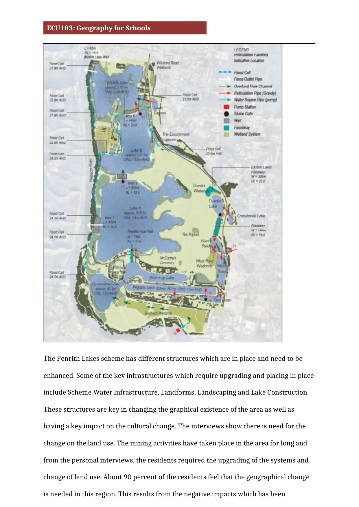
The Penrith Lakes scheme has different structures which are in place and need to be
enhanced. Some of the key infrastructures which require upgrading and placing in place
include Scheme Water Infrastructure, Landforms, Landscaping and Lake Construction.
These structures are key in changing the graphical existence of the area as well as
having a key impact on the cultural change. The interviews show there is need for the
change on the land use. The mining activities have taken place in the area for long and
from the personal interviews, the residents required the upgrading of the systems and
change of land use. About 90 percent of the residents feel that the geographical change
is needed in this region. This results from the negative impacts which has been
⊘ This is a preview!⊘
Do you want full access?
Subscribe today to unlock all pages.

Trusted by 1+ million students worldwide
ECU103: Geography for Schools
experienced from the mining activities in the region. In addition, the cultural change will
have economic benefits to the region than the current activities. The provided master
plan involves key activities which include soil rehabilitation and development of land
reforms, reconstruction of native animal population, establishment of relevant
Cumberland vegetation and grassland therefore restoring the resilient ecosystem,
habitat and native animals as well as conservation of the vegetative cover. All these
activities are meant to be achieved through land use changing in the region. Their
impact has been achieved due to the current mining activities which has been carried
out for long in the region. In addition, these activities will enhance the regional
economic upgrade. 87% of the residents feel that the change on the land use and
geography of the area will position them well in tourism sector. The introduction of the
lake region ion the area, manmade will help to enhance recreation facilities according to
the residents and thus changing the cultural nature of the people. Survey shows that
the residents are aware of the high pollution rates and also the environmental
degradations happening due to the mining activities in the region.
Discussion
Plans to redevelop the Penrith Lakes scheme have been well received by the residents
owing the key benefits they are attributing to receive from the change of the land use.
Geographically, the residents feel that they will be well positioned to mitigate the
negative environmental effects they have experienced from the mining activities.
Therefore, the residents feel it is worth and relevant to have the Penrith Lakes scheme
upgrading scheme in place. In addition, the change of geography will be experience
much since the plan involves change of land use. Mining activities have been carried in
the area for more than 150 years in the region. Environmental degradation has been
experienced as well as the high pollution status being experienced. These are some of
the key geographical impacts which the residents have raised to support the land use
plan. Culturally, the residents will have to change. This relate directly to the
Paraphrase This Document
Need a fresh take? Get an instant paraphrase of this document with our AI Paraphraser
ECU103: Geography for Schools
geographical change which will result to the change on the economic activities on the
region. The residents are positive about the change and feel that they will be better
positioned in terms of economic activities from the land use development and change.
The geographical perception of the residents is well supported in terms of the rise of
new economic activities after the change on land use redevelopment of the area.
Recreational activities and also tourism activities are likely to rise due to the change of
the land use. These perceptions are related to the land use change activities. Although
mining has been creating different economic activities, their level of economic
development has not been enough to convince the resident to maintain the mining
activities.
Emerging activities such as tourism are the major anticipation by the citizens. The
Penrith Lakes scheme development is therefore important to develop a new economic
zone with new activities within the region. The nature of the activities and distribution
are likely to benefit the region more in terms of economic activities than the mining.
These activities will introduce new economic activities which high number of the
residents can benefit from. In addition, development of the Penrith Lakes scheme is
likely to lead to reduced pollution and other negative impacts are likely to be
experienced due to the mining activities over the past years. The mining activities have
wasted the ecosystem, polluted the area and high destruction of the existing
infrastructures. These experienced have been experienced in this region for long and
change of land use is likely to mitigate about 80% of the negative impacts. New features
for new economic activities will be created such as the lakes. These are able to make use
of the deep excavations which has been experienced in the region. The emerging
features and structures will help in mitigating the negative impacts as well as enhancing
the economic position of the region. The development of the region is therefore an
important consideration which is supported with key factors. The geographical change
will be experienced due to the change and thus enhancing the locational improvement.
ECU103: Geography for Schools
Conclusion
The geographical structure of Penrith Lakes scheme is clear it requires proper look and
change. The Penrith Lakes scheme is able to show the need of such change in order to
mitigate some of the key negative impacts which has been experienced. Economically,
the change on geography and land use will be able to benefit many residents than the
current mining activities. The information gathered show that more than 90% of the
residents are able to support the change on the land use. Their own perception is that
the regions and economic activities will be able to improve from the change. In addition,
more than 80% feel that the mining activities have created more negative impacts to
them than the benefits they are experiencing. The area has experience environmental
degradation for long and recreation structures will be needed to improve the land use.
The change is therefore a positive change which all people are positive regardless of the
key challenges. The upgrading due to the land use is therefore important for the region.
Environmental mitigation measures are needed and the landform regeneration will help
to enhance the geographical view and nature of the region.
⊘ This is a preview!⊘
Do you want full access?
Subscribe today to unlock all pages.

Trusted by 1+ million students worldwide
1 out of 6
Related Documents
Your All-in-One AI-Powered Toolkit for Academic Success.
+13062052269
info@desklib.com
Available 24*7 on WhatsApp / Email
![[object Object]](/_next/static/media/star-bottom.7253800d.svg)
Unlock your academic potential
Copyright © 2020–2026 A2Z Services. All Rights Reserved. Developed and managed by ZUCOL.


