Project Development and Planning: Great Ocean Road Project
VerifiedAdded on 2020/05/16
|21
|5468
|33
Project
AI Summary
This project delves into the intricacies of project development and planning, focusing on a single dwelling at 5420 Great Ocean Road, Wongarra, Victoria. It meticulously examines the planning process, emphasizing the importance of consultation with local authorities and adherence to state and local planning frameworks. The project explores the roles of various professionals, including architects, civil engineers, ecologists, and geotechnical engineers, in ensuring compliance with regulations and sustainable development practices. The analysis includes a detailed site analysis, consideration of state and local planning policies, and an assessment of development requirements, including zones and overlays. The project highlights the significance of the Victorian Civil and Administrative Tribunal (VCAT) in resolving disputes and ensuring proper land development procedures. The project also provides property details, including land size and ownership, and addresses the client's brief, emphasizing the need for compliance and the involvement of various experts to ensure a successful and sustainable development. The project's primary focus is the development of a single dwelling, considering all the necessary aspects of planning and regulations.
PROJECT DEVELOPMENT AND PLANNING.
Student’s Name:
Institutional Affiliation:
Tutor’s name:
Student’s Name:
Institutional Affiliation:
Tutor’s name:
Paraphrase This Document
Need a fresh take? Get an instant paraphrase of this document with our AI Paraphraser
Contents
INTRODUCTION.....................................................................................................................................2
PROPERTY DEVELOPMENT...............................................................................................................8
Development of a Single Dwelling at 5420 Great Ocean Road, Wongarra.......................................8
The brief.................................................................................................................................................8
Property details......................................................................................................................................9
Site analysis..........................................................................................................................................10
State planning policy framework.......................................................................................................12
Local and municipal planning framework........................................................................................13
Development assessment.....................................................................................................................16
Zones.................................................................................................................................................16
Overlay.............................................................................................................................................17
Conclusion................................................................................................................................................18
References................................................................................................................................................19
INTRODUCTION
The planning process is of fundamental importance when establishing a commercial or
residential building. The consultation with the local authorities as well as the neighborhood will
determine the efficiency and smoothness of operations. Therefore, prior to the actual process,
any contractor and client will have to look into detail the area covered and under whose
jurisdiction the building permits fall. Various clause stipulated may change over time and it is the
responsibility of the contractor to ensure that his/her compliance is the most updated version.
The idea that development is continuous is to a large extent true. However, development issues
are accompanied by negative factors such as environmental degradation, pollution, societal
impacts among others (Envision Eugene Technical Resource Group, 2011). Considering that the
major purpose of development is to increase the comfort levels within the human population, the
local authorities review the various clauses from time to time. These clauses outline the purpose
and responsibility of each individual involved in a development project. It is also their
responsibility to enforce the clauses and as such may decline or accept.
The development of any land within a given state is usually under a specified authority. As with
Victoria, the parties mandated with this responsibility are three: the authorities responsible in this
case the council, the minister affiliated with planning and the VCAT (Etherton & Walker,
n.d.).However, the process is complex and involves consultation with the various affiliated
parties with the main concern not to infringe on any of the laws or guidelines stipulated. Land
development by any client may not necessarily follow the rules of the council and if this is the
case, the council may decline to approve the development (Gurran, 2007). However, a proper
appeal to the VCAT by the aggrieved party may see the decision overturned. Therefore, the
⊘ This is a preview!⊘
Do you want full access?
Subscribe today to unlock all pages.
Trusted by 1+ million students worldwide
VCAT plays a major role in ensuring that land development in Vitoria follows the necessary
steps and laws (Condliffe & Abrahams, 2010).
The laws are used to describe and regulate the planning and development activities that go on
around any particular region. As a matter of fact, there are two types of planning that may be
encompassed in any development: statutory and strategic planning (Etherton & Walker, n.d.).
The former refers to planning that is centered on the present while the latter focuses on the long-
term development of the area (March 2010). Besides the two, there are various amendments that
are used in the development of the region. Moreover, there are two types of frameworks that
should be followed prior to the development of any piece of land: the state planning policy
framework and the local planning policy framework.
The state planning policy framework describes the platform through which development around
the state is to be carried out (Sourdin, 2007). It is therefore written and implemented by the
government of a particular state, developing and at the same time maintaining the desirable
visions. On the other hand, the local planning policy framework is mainly composed of the local
and municipal policies of a particular region (Albrechts, 2015). In this, the framework oversees
the development of land and provides or revokes permits according to the compliance. However,
the local planning policy framework has to be in sync with the state planning policy framework.
The state planning policy framework, as stated above, describes the desired values of land in line
with the goals of sustainable development (Dempsey, et al., 2011). Therefore, ecology, as well as
biodiversity, is a major player in the policies that are drafted by the state. In this, one major
concern is the protection of the natural environment particularly the biodiversity and the
ecosysystems.No planning should bring harm to an otherwise stable and sustainable ecology
(Cuthill, 2010). This stipulation, therefore, requires the planners to work with other disciplines
Paraphrase This Document
Need a fresh take? Get an instant paraphrase of this document with our AI Paraphraser
such as environment and biodiversity experts in order to ensure that the compliance is not
questionable. Because various organizations have come out in defense of the ecological systems
around the world, it is no surprise that attached to these principles are those of international
organizations as well as the local organizations. A major national agreement on the sustainable
use of land is the intergovernmental agreement on the environment (Godden & Kung, 2011).
Other agreements mainly build upon the principles set in the aforementioned.in a nutshell, the
protection of the biodiversity of these regions is a statutory planning approach that is meant to
ensure that the natural ecosystems of the region are not affected in such a way that they may not
be able to meet the needs of the future, as per the goals of sustainable development.
Because the local planning policy framework is built on the principles of the state policy
framework, the major concern is that of the land use and the protection of detailed ecosystems
and ecologies such as the groundwater, catchments, and waterways among others (Taylor, 2013).
It is the responsibility of every municipal to ensure that the resources within the boundaries are
well taken care of and the effect of urbanization and development does not compromise the
ability of the stated to sustain themselves.
Planners need to consider overlays if the development plan is to be smooth, efficient and
successive. The choice of land for development may call for a developer to consider or not
consider the overlay principles. This is because some lands may have an aspect of overlay while
others do not have it. Overlays refer to extra rules and clauses that govern the development of
certain pieces of lands (Thompson & Maginn, 2012). Some lands may contain a unique aspect of
cultural diversity, heritage and even ecology.
As stated, there are various groups of professionals, besides the planners, that are involved in the
development practice. The larger the group, the costly the practice becomes but the more
compliant it becomes. Some of these professionals include the architect or engineer, surveyor,
wildlife and ecological engineers, surveyors, geotechnical engineers, arborists, hydrologic
engineers, geotechnical engineers among others. With each group of professionals comes the
compliance to the local, municipal and state laws. Therefore, it is important to discuss these
professionals in detail in order to ensure that the development of any piece of land is covered
To begin with, the architect and the client need to read from the same script as a simple
misunderstanding may result to drawings that do not meet the latter’s satisfaction. Buildings vary
in size and shape and if there is improper consultation between the two groups, a full or half
design and redraw may cost both precious time and resources. It is the responsibility of the client
to detail the architect on the specifications regarding structural plans in any particular region
because this, to a large extent determines compliance and the susceptibility that local authority
may revoke the development plan. The location of the ventilation mechanisms, the walling
structure, the land area to be covered are all the responsibility of the architect.However, a civil
engineer is another profession, closely related to the architect, that the client should consult in
relation to the drawing plans. Civil engineers are the group of professionals who are involved in
determining the structural layout of the proposed building and determine the size and location of
the various elements involved in the structural design. The structure may be a building, road,
dam etc. and therefore should be in regular consultative meetings with both the aforementioned
parties.
The second group of professionals is that involved in the natural ecosystems and ecologies. The
ecology and natural ecosystem of any specific region should be maintained as per the statutory
planning approach and therefore, the geologists, hydrologists, wildlife experts, arborists, and
ecologists should be considered in the development plans (Dobson, 2007). Their input to this
⊘ This is a preview!⊘
Do you want full access?
Subscribe today to unlock all pages.
Trusted by 1+ million students worldwide
process is priceless and are the first group of individuals to be consulted prior to the actual
implementation and design stages. To begin with, the geotechnical engineers provide much detail
on the soil conditions of a particular region by using their expertise to determine the suitability of
the soil for development purposes. Some regions are susceptible to erosion while others may be
subject to liquefaction, mass movement etc. Most importantly, they are very useful in regions
that may be described to be within an erosion management overlay (Vassey-Ellis, 2009). They
furthermore provide reports on the landslip and the capability of the land to sustain the various
structures proposed. On the other hand, ecologists provide a detailed report on the classification
of the various plant and wildlife species on the area to be developed.
The most important aspect of development is the consideration of the various land and
development practices stipulated by the local as well as the state laws. Finally, the cultural
heritage of a specified piece of development area may be observed by archaeologists who
determine the value of the land on the basis of the detail of the materials observed. Therefore, all
the parties involved in the act should be well equipped with the knowledge of the particular
locality but most importantly should act as a single unit for the ultimate completion of the
project. Any development proposal has to be approved by the local council and if the council
declines to approve the request, a challenge to the decision is looked into by the VCAT. An
example of this challenge may be observed in the development of the six-storey building at 57
Nelson place. The development of the building was on the land that was occupied by the oriental
hotel building. Though the building was old, it signified the heritage of the Hobson bay district.
Interestingly, the development proposal had been declined by the municipal council but this was
subject to the appeal case taken to the Victorian civil and administrative tribunal. In this regard,
the decision revoking the development of the new storey was overturned (Leshinsky, et al.,
Paraphrase This Document
Need a fresh take? Get an instant paraphrase of this document with our AI Paraphraser

2012). Therefore, the building may be described to bring out some of the fundamental aspects of
planning as it considers the old building to have some heritage impact on the locality. The
heritage is part of the state planning policy framework as well as the municipal policy planning
framework.
planning as it considers the old building to have some heritage impact on the locality. The
heritage is part of the state planning policy framework as well as the municipal policy planning
framework.
PROPERTY DEVELOPMENT
Development of a Single Dwelling at 5420 Great Ocean Road, Wongarra
The brief
The client has devolved the task of developing the land and as such, has delegated all duties to
our team. The preliminary investigation and report are to signify our compliance with the
conditions that the client views as very suitable for development. All the documents that involve
the piece of land and any government affiliations are to be used with the various members of the
team to ensure that there is no breach of contract and no infringement to the property rights both
to the government and to the neighborhood.
The development of this piece of land will be intensive and is not intended to infringe on the
various clauses that are stipulated under the municipal policy framework as well as the state
policy framework. All in line with proper development measures, some of the professionals
involved in the development of the housing as well as the disposal units will include
geotechnical engineers, surveyors, architects, geologists, ecologists, civil engineers,
archaeologists among others (Clark & Dickson, 2003).However, the concern will particularly be
most predominant on the geologists because of the proximity of the housing units to Smyth's
creek.
⊘ This is a preview!⊘
Do you want full access?
Subscribe today to unlock all pages.
Trusted by 1+ million students worldwide
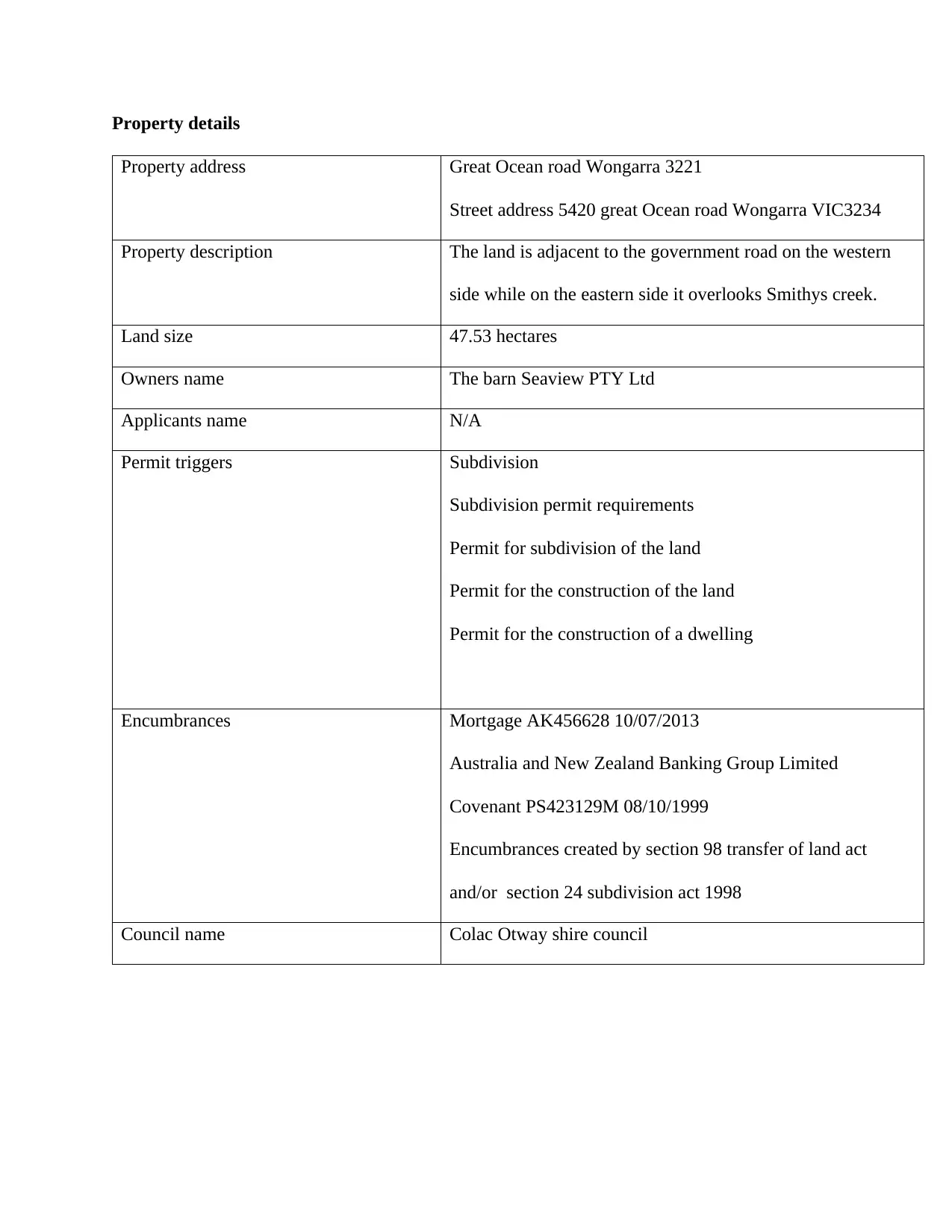
Property details
Property address Great Ocean road Wongarra 3221
Street address 5420 great Ocean road Wongarra VIC3234
Property description The land is adjacent to the government road on the western
side while on the eastern side it overlooks Smithys creek.
Land size 47.53 hectares
Owners name The barn Seaview PTY Ltd
Applicants name N/A
Permit triggers Subdivision
Subdivision permit requirements
Permit for subdivision of the land
Permit for the construction of the land
Permit for the construction of a dwelling
Encumbrances Mortgage AK456628 10/07/2013
Australia and New Zealand Banking Group Limited
Covenant PS423129M 08/10/1999
Encumbrances created by section 98 transfer of land act
and/or section 24 subdivision act 1998
Council name Colac Otway shire council
Paraphrase This Document
Need a fresh take? Get an instant paraphrase of this document with our AI Paraphraser
Site analysis
The site analysis of the rea may provide significant insight into the potential problems that may
arise due to the building and as such, provides a valuable source of green or red light in regards
to the development (Carroll & Buchholtz, 2014).To begin with, the size of the land is
approximately 49.7 hectares with the area divided into two portions each having a different
purpose. However, this is as per the specification of the client and a huge portion of the
compound will be bare.
The second aspect to be considered is the existing and previous land use of the area but
according to the plans, the land is relatively inhabited with only the small forest covering a
certain patch of the land. The development will have to consider the environmental impacts as
well as the views of the arborists who may be involved in the survey and inspection of the land.
Furthermore, the design will have to consider the government road that aligns itself along the
perimeter of the site but on the eastern portion of the land. The fact that the neighborhood is not
predominantly occupied may create some breathing space for the development because
according to the plan, there are no buildings within the allocated region, with the majority of the
land covered by forest and trees.
The third factor to be considered in the site analysis is the planning provisions that are to be
adhered to prior to the actual planning (Coffey, et al., 2011). In this, there are four planning
frameworks that will be involved: the state framework, the municipal framework, the local
framework and the Colac Otway framework. These frameworks stipulate the development
procedures and restrictions on such a piece of land and are therefore very useful for development
purposes. The local and municipal policy framework is, by all means, an extension of the state
policy framework but provides detailed input to the development phase.
Another factor to be considered in the site analysis revolves around the shape and slope of the
land. In this regard, the land is predominantly flat but with a creek on the northern side while the
western side is relatively sloppy giving way to the ocean beyond the perimeter wall. However,
the perimeter wall on this side borders the great ocean road and adjacent to the ocean road is the
ocean.
The local context of the region is as equally as important as the tract of land to be developed and
as such is very useful in the planning during the construction as well as during the period when
the land will be used for the intended purposes. To begin with, the regions that surround the
proposed development site are predominantly bear with only the government road and the ocean
road surrounding the southern and western portions of the adjacent land. However, the southern
part of the land is labeled as a reserve and to the farthest end is the Smithys creek. Furthermore,
the land development is relatively low with the main tracts of land covered by forests and creek.
Moreover, the description of the land does not signify any hazard that may be present at the
locality. This is prior to the actual site investigation which may indicate otherwise. Another
description pertains the accessibility to this site and as indicated by the plan, the land is enclosed
throughout with the whole perimeter showing no signs of an accessibility point. Finally, the flora
and fauna of the site, as shown from the contour map, have been greatly cleared save for the
small portion of land which contains a number of trees.
⊘ This is a preview!⊘
Do you want full access?
Subscribe today to unlock all pages.
Trusted by 1+ million students worldwide
1 out of 21
Related Documents


Your All-in-One AI-Powered Toolkit for Academic Success.
+13062052269
info@desklib.com
Available 24*7 on WhatsApp / Email
![[object Object]](/_next/static/media/star-bottom.7253800d.svg)
Unlock your academic potential
Copyright © 2020–2026 A2Z Services. All Rights Reserved. Developed and managed by ZUCOL.