Australia Mining: Prospecting, Exploration, and JORC Code Research
VerifiedAdded on 2023/06/14
|14
|3810
|273
AI Summary
This research paper provides an in-depth analysis of mineral prospecting and exploration strategies in Australia. It begins by defining exploration and prospecting, highlighting their objectives, and outlining essential techniques such as geological mapping, geophysical methods, and geochemical surveys. The paper examines specific mining locations in Australia, detailing their geographical settings, shareholding companies, ore-bearing rocks, and economic uses. It addresses the critical environmental aspects of mining, emphasizing the importance of risk assessment, heritage preservation, and compliance with national park regulations and native title acts. Furthermore, the research explains the JORC code, emphasizing transparency, materiality, and the role of competent persons in ensuring accurate and reliable reporting of exploration results and mineral resources. This paper underscores the need for sustainable and responsible mining practices in Australia, balancing economic interests with environmental and cultural preservation. Desklib provides access to similar solved assignments and research papers for students.
Prospecting and Exploration 1
RESEARCH PAPER ON MINING IN AUSTRALIA
A Research Paper on Mining By
Student’s Name
Name of the Professor
Institutional Affiliation
City/State
Year/Month/Day
RESEARCH PAPER ON MINING IN AUSTRALIA
A Research Paper on Mining By
Student’s Name
Name of the Professor
Institutional Affiliation
City/State
Year/Month/Day
Paraphrase This Document
Need a fresh take? Get an instant paraphrase of this document with our AI Paraphraser
Prospecting and Exploration 2
INTRODUCTION
This research paper is about prospecting and exploration of minerals in Australia.
Exploration is the process of getting commercially viable mineral concentration from a particular
mine while prospecting can be defined as the process of searching for an exploitable
economically minerals deposits. The prospecting and exploration strategies that need to be
undertaken to enable the acquisition of the mineral deposit include geological mapping,
geophysical techniques, and geophysical methods. Transparency and materiality are the main
principles of the NJORC codes and the competent person must give explanation on the
assumption of materials underlying the declaration of the exploration results, ore reserves and
mineral resources.
Question 1
Exploration
Mineral exploration is the process of getting commercially viable mineral concentration from a
particular mine. The process is more intensive, professional and organized form of mineral
prospecting and it uses the prospecting services. The process starts with finding and exploration
of the deposit of minerals. The geologist and surveyors are prominent in the study of the
feasibility of the future operation of mining. The process is based on the scientific understanding
of the modern equipment. It involves the geochemical and geological mapping, techniques of
geochemical and satellite imagery (Botin, 2013).
Prospecting is the process of searching for the exploitable economically minerals deposits. It
involves roaming the areas for the indication of the mineralization of the ores outcrops, soils and
sediments. The red, yellow and brown of the limonitic materials can show the sulfide-bearing
Prospecting and Exploration 3
veins leaching and the disseminated body of the ore. Blue, weathered outcrops and green could
show the oxidized copper minerals, black can show the presence of the oxidized minerals of
manganese and green and yellow can show the presence of silver halides (Bullock, 2011).
Objectives of exploration include:
To improve the understanding of the impact of the activity of the igneous. The process of
exploration helps the miners to understand the effects of igneous activities which may be
advantageous or dangerous to the mining process. Exploration process assists in the
evaluation of the behaviour of different igneous activities when subjected to different
circumstances (Committee, 2014). The reports compiled after the exploration of a site by
the explorers and geologist engineers will be used by the future individuals who may
have interest in the site for the purposes of mineralization or rehabilitation of the site.
These individuals will find it easy to understand the igneous activities of the particular
site already explored by the previous researchers.
To map the geochemical footprints and alterations under the cover and also assessing the
economic potential of the area of states geology. The process of exploration assist in the
evaluation of the potential of a given region through experimental setup performed to
determine the nature of the area in terms of its geology. The potential sites that have high
chances of possessing minerals for future mineralization making it easy for the current
miners to locate these sites and carry out mining activities.
To identify the vectors of regional scales to mineralization. The process of exploration
assists in the identification of potential areas where minerals are present. The regional
scale vectors for the potential sites can be identified through exploration of different sites
in different geographical regions (Magazine, 2013). The exploration process also makes
it possible for the miners to know the extent to which the region which has minerals is
extended to. These regional scales are critical in the evaluation of the number of minerals
a particular site possesses and whether to go on with the mining process or not.
To support and apply real-time data collection technology. The process of exploration
enables the researchers to apply the real-time data collection technology which makes the
research to more accurate and fasters. The real-time data collection technology is
⊘ This is a preview!⊘
Do you want full access?
Subscribe today to unlock all pages.
Trusted by 1+ million students worldwide
Prospecting and Exploration 4
important when the mineralization process need to be performed immediately after the
exploration process. There are currently numerous technologies that are currently being
used by the explorers for the purposes of data collection which provides accurate data for
a short duration. These technologies are backed up with laboratory testing of the samples
collected from the site when determining the mineralization of a particular site
To test the prospective indices made from the earlier studies. The process of exploration
assist the explorers to determine the validity of the prospective indices made from the
previous researchers. Different regions are likely to change geographically with time
making it necessary to carry out frequent exploration of these sites by the use of real-time
data collection technology to provide the data at that particular time (Institute, 2013).
The prospecting and exploration strategies that need to be undertaken in the acquisition of the
mineral deposit
Geological mapping; this is the pictorial surface record and or the underground geological data.
The aerial photos are normally used as the basis of mapping since they show the topography.
Mapping selects an area for the mineral for the more expensive techniques to be employed where
they can be successful (Hustrulid, 2012).
Geophysical techniques; it involves the seismic methods, magnetic methods for identifying the
iron ore, gravity methods to identify the underlying rocks which are less dense than the rock on
the surrounding, and the electrical method.
Geophysical methods; this is the done in the boreholes and involves measuring the diameter of
the hole, electromagnetic ray logging, density logging and resistivity logging. It includes the
geochemical surveys, remote sensing and identification of fossils (Institute, 2014)
Question 2
State Name and
geographical
Geographical
setting
Shareholding
company
Major ore-
bearing rock
Economic use
of the deposit
Paraphrase This Document
Need a fresh take? Get an instant paraphrase of this document with our AI Paraphraser
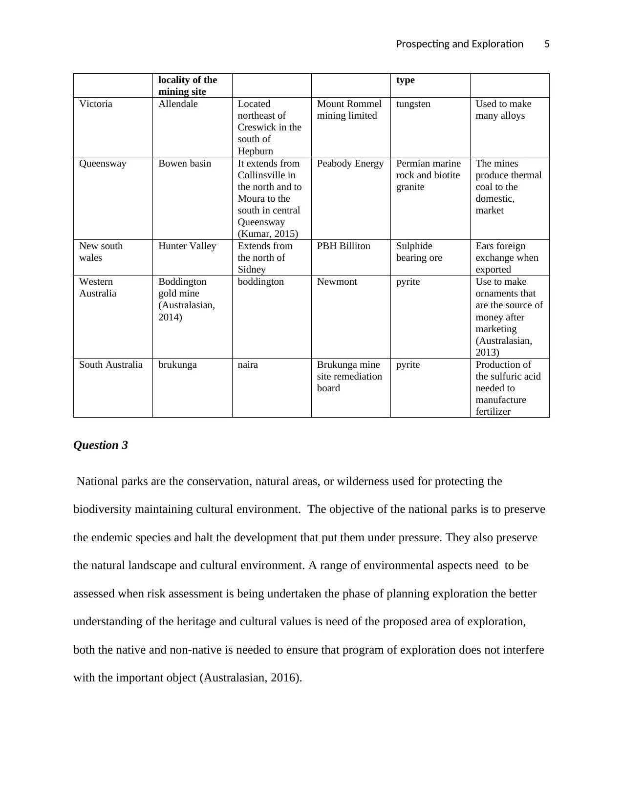
Prospecting and Exploration 5
locality of the
mining site
type
Victoria Allendale Located
northeast of
Creswick in the
south of
Hepburn
Mount Rommel
mining limited
tungsten Used to make
many alloys
Queensway Bowen basin It extends from
Collinsville in
the north and to
Moura to the
south in central
Queensway
(Kumar, 2015)
Peabody Energy Permian marine
rock and biotite
granite
The mines
produce thermal
coal to the
domestic,
market
New south
wales
Hunter Valley Extends from
the north of
Sidney
PBH Billiton Sulphide
bearing ore
Ears foreign
exchange when
exported
Western
Australia
Boddington
gold mine
(Australasian,
2014)
boddington Newmont pyrite Use to make
ornaments that
are the source of
money after
marketing
(Australasian,
2013)
South Australia brukunga naira Brukunga mine
site remediation
board
pyrite Production of
the sulfuric acid
needed to
manufacture
fertilizer
Question 3
National parks are the conservation, natural areas, or wilderness used for protecting the
biodiversity maintaining cultural environment. The objective of the national parks is to preserve
the endemic species and halt the development that put them under pressure. They also preserve
the natural landscape and cultural environment. A range of environmental aspects need to be
assessed when risk assessment is being undertaken the phase of planning exploration the better
understanding of the heritage and cultural values is need of the proposed area of exploration,
both the native and non-native is needed to ensure that program of exploration does not interfere
with the important object (Australasian, 2016).
Prospecting and Exploration 6
Under the act of 1974 of national parks and wildlife, it is an offence for a person to harm any
object in the national park both native and non-native in the case of mining. Good planned and
managed exploration should have less impact on the plants, animals, threatened and endangered
species. It is needed that a person should no pick any species in the park or harm and should not
do anything that causes the damage to the critically endangered species (Australasian, 2014).
The act of their native identify the title of the native that may exist in some of the lands.
Normally, some of the acts such as giving freehold title or some leases over their land may
extinguish the title of native over the land. Where there is the existence of the native title, the
authorities of mining may be given the requirements to negotiate a good agreement with the
relevant titles before the commencement of the undisturbed natural development. If the
conditions of the permit procedures are met the exploration can take place in the national parks
(Navin, 2010).
Native title has become very important in the Australia and mining law is not complete without
taking it into consideration. This legislation protects and recognizes the native title rights against
the dealing ion the land in future including all the operation of mining. The title rights should
exist in accordance with the customs and the laws of the aboriginal people, where they have,
managed their traditional connection with the titles and their lands have not been removed by the
law. Native title rights have become very important to the miners because the native title act
issues the holders of the title rights to negotiate with the projects including the grant to mining
and exploration (Pohl, 2010).
A party may apply for the tribunal for the determination that will consider allowing the activity if
mining in a certain site. Aboriginal cultural heritage may exist on the land that doesn't depend on
the interest of the existed native title. All the states have the rules and laws that give the
⊘ This is a preview!⊘
Do you want full access?
Subscribe today to unlock all pages.
Trusted by 1+ million students worldwide
Prospecting and Exploration 7
protection to the native archaeological sites by way of the consent of the minister. A miner is
needed to get the clearance of the aboriginal heritage before starting any mining operation on the
site (Register, 2013).
The requirements of the aboriginal heritage and native title issuers that many miners are required
to face as the mineral deposit that tends to be in areas with many native populations. Legislation
of the native title need both the native claimants and miners to consider the interest of one
another. Negotiation can take time and where the miners are not familiar with the norms and
culture of the native communities, may need the assistance of the experienced experts. The
interested native parties can allow the miners to the traditional lands or sites and need
compensation which may include the royalties, incentives, cash payments and training
(Academy, 2012).
Question 4
JORC code is the code for the reporting on the public and not to regulate how the competent
person estimates the ore reserves and mineral resources. The code also sets minimum standards
for the results of the mineral exploration, ore reserves and mineral resources. JORC compliant is
the manner of reporting and not to the estimates. The reports prepared by the JORC codes are
used by the investors for the purposes of comparison with the exploration reports in case there is
compliance with the codes. JORC sets minimum standards for the public reports of the ore
reserves, mineral resources and exploration results. It provides the mandatory system for the
grade and tonnage classification and estimates according to the confidence of geology (Subhash,
2014). There is need for a competent person to undertake all the processes involved. For the
exploration results to be accepted by the JORC, it must be;
Paraphrase This Document
Need a fresh take? Get an instant paraphrase of this document with our AI Paraphraser
Prospecting and Exploration 8
Clear and unambiguous; the result should be transparent to enable the reader to
understand all the information the competent person should ensure that the readers are
not misled with the information
Materiality; it requires that the report have all the important information that the
professional advisors would need, and what they are expecting to find in the report to
make a good decision regarding the exploration results.
Competence; it needs the report to be made by the responsible and qualified person
known as the competent person (Sutcliffe, 2010).
All the disclosures of the exploration target must show the description of the process to know the
tonnage band grade used to describe the exploration target. Exploration target is the statement
that defines the set of geology where the estimates quoted as the range of grade and tonnage
relates to mineralization. Exploration results are the data and information produced by the
program of the mineral exploration that can be useful to the investors but is not among the
declaration of the mineral resources (Sutcliffe, 2010).
Transparency and materiality are the main principles of the NJORC codes and the competent
person must provide explanation on the assumption of materials underlying the declaration of the
exploration results, ore reserves and mineral resources. The benchmark of the materiality should
be considered that includes the aspects relating to the exploration results that the advisors would
want to see the competent person. The competent person should not be silent on any aspect of the
absence or the presence of comment can interfere with the perception of the public or the value
of the occurrence of the minerals. The clear maps and diagrams that represent the context of
geology must be included in the public report (Association, 2014)
Prospecting and Exploration 9
A public report concerning the exploration results and targets of the company and must reflect
the documentation prepared by an individual who is competent. The company providing the
public report should indicate the name of the competent person and also if the person is a full-
time employee and the person's employer. The potential for the conflict of interest by the
competent person must be disclosed according to the principle of transparency. The relationship
between the company and the competent person that has made the report must be disclosed in the
public report. The report must be compiled together with the written consent of the competent
person as to the context of how it appears (Kumar, 2014).
A competent person is a mineral industry professional who is a member of Institute of
metallurgy and mining in Australia, or the Institute of a recognized professional organization or
the Institute of the geoscientist. The person must have a minimum of 5-year experience that is
relevant in the style of mineralization and in the field being undertaken by the individual. In case
the competent person is compiling documentation on the results of exploration, the relevant
experience must be in exploration. The competent person must have relevant experience in
approximation in case the person is to estimate or supervise mineral resources. The major
qualifier in the description of a competent person is in the word relevant. The determination of
what institute relevant experience may be a common sense exercise (Committee, 2014).
In addition to the experience in the mineralization style, the individual responsible for the
compilation of the results of exploration should have adequate experience in the relevant
technique of analytics and sampling to the deposit under consideration to understand the problem
may affect the reliability of the information. The individual should be satisfied clearly in their
mind that they can demonstrate and face their peers in the community and in case there is the
⊘ This is a preview!⊘
Do you want full access?
Subscribe today to unlock all pages.
Trusted by 1+ million students worldwide
Prospecting and Exploration 10
existence of doubt, the person should seek assistance from other experienced peers (Kumar,
2015).
Question 5
There is some critical information that the engineering geologist provide to the technical services
division for the whole of mine plan. The engineering geologist provides information concerning
the management of the mine and the potential mineralized zone to the technical service division.
The geologist provides maps that describe structures, rocks, and minerals occurring in the region
in the mine plan. The explanation should be provided concerning the calculation of the ore and
how it can become of economic importance when mined. The information on the mine plan
basically will entail boundaries and type of on-site rocks, geologic features, geologic units, man-
made and natural features, proposed and natural topography (Kumar, 2015).
The engineering geologist provides the information on the type of testing that was performed on
the region, the interval in which the samples were taken, and the type of samples that were used
in conducting the assessment of the mine site. The information concerning the history of the
mine site including the description of the proposed, existing, and previous land use of the site is
also provided by the engineering geologist to the technical services division. All the mine site
usage including previous earthwork, subsurface and surface storage, structures, basements,
underground storage tank, septic tanks, pits, trash and debris are also provided by the
engineering geologist. The present and past usage of the mine site, waste disposal, industrial
production, hazardous substance, toxic, pesticides, fertilizers, chemicals, farming, animal
grazing, poultry, dairy, and any agricultural activities should also be included in the report
(Magazine, 2013).
Paraphrase This Document
Need a fresh take? Get an instant paraphrase of this document with our AI Paraphraser
Prospecting and Exploration 11
The report by the engineering geologist should also propose a mitigation method that will be
suitable for the proposed use. Well-Substantiated and clear recommendations should be
presented to show the remedial methods, procedures, and actions which should be applied on the
mine site to mitigate the potentials of any risks during exploration and mining process. In case
the removals are considered as the mitigation measure, then specific limits and depths or removal
should be indicated and be based on the data obtained from engineering characteristics and
boring logs of materials evaluated through lab testing (Hustrulid, 2012).
Limits and depths of over-excavation should concur with qualitative and quantitative data
presented in the report. Every testing performed in the laboratory on the samples should include
calculations and graphs. The engineering geologist should indicate the consultant geologist who
coordinated the design of mitigation with project engineer, architect, foundation engineer, and
structural engineer. The report submitted to the technical services division should indicate that
the consultant soil geologist has visited the mine site and verified the supporting data
(Committee, 2014).
Conclusion
Australia is known as one of the leading nations in mining because of the transparency and
openness of the mining investments and the legal framework. The coherent system provides the
industry with certainty to the participants. It is very important to know the relationship certainty
and transparency and hence positive impact is seen in the overall sector of mining. The
prospecting and exploration strategies which have been discussed in this research paper that need
to be undertaken in the acquisition of the mineral deposit include geological mapping,
geophysical techniques, and geophysical methods. The engineering geologist provides the
information concerning the type of testing that was performed on the region, the interval in

Prospecting and Exploration 12
which the samples were taken, and the type of samples that were used in conducting the
assessment of the mine site to the technical services division.
which the samples were taken, and the type of samples that were used in conducting the
assessment of the mine site to the technical services division.
⊘ This is a preview!⊘
Do you want full access?
Subscribe today to unlock all pages.
Trusted by 1+ million students worldwide
1 out of 14
Related Documents


Your All-in-One AI-Powered Toolkit for Academic Success.
+13062052269
info@desklib.com
Available 24*7 on WhatsApp / Email
![[object Object]](/_next/static/media/star-bottom.7253800d.svg)
Unlock your academic potential
Copyright © 2020–2026 A2Z Services. All Rights Reserved. Developed and managed by ZUCOL.