Comprehensive Analysis of Physical Geography: Rock Cycle and Tectonics
VerifiedAdded on 2023/05/30
|12
|2277
|418
Homework Assignment
AI Summary
This assignment delves into various aspects of physical geography, beginning with an examination of the rock cycle and the interconnections between granite, shale, and schist through geological processes like melting, erosion, and solifluction. It then explores convergent plate boundaries, detailing the movement of plates and the formation of volcanic arcs and island arcs. The assignment further analyzes stratovolcanoes, using Cleveland volcano as an example, and discusses the creation of the Aleutian Islands through plate interactions. It also identifies and explains different types of mass movements such as earthflows, creep, debris flows, rockfalls, solifluction, slumps, and lahars, linking them to a provided figure. Finally, the assignment describes sedimentary environments, focusing on fluvial settings and the formation of cut banks, point bars, and oxbow lakes, illustrating the dynamic processes shaping the Earth's surface. Desklib offers a variety of study tools and solved assignments for students.

Running head: PHYSICAL GEOGRAPHY
1
Physical geography
Name:
Institution:
1
Physical geography
Name:
Institution:
Paraphrase This Document
Need a fresh take? Get an instant paraphrase of this document with our AI Paraphraser
PHYSICAL GEOGRAPHY 2
Question one
When comparing schist (metamorphic rock), granite (igneous rock), and shale
(sedimentary rock), one can comprehend that through the rock cycles, each one of these rocks
can connect to the other through geological processes such as melting, erosion and Solifluction.
Similarly, the evidence of this variation can be established in the rocks by evaluating the
chemical composition, or in some cases, even pre-existing aspects in the rock that have been
preserved (Hu, Liu & Dong, 2014).
First, granite can change to shale (igneous to sedimentary); granite to schist (igneous to
metamorphic); granite to granite (igneous to igneous). Secondly, schist can change to shale
through the metamorphic to sedimentary process; schist to granite (metamorphic to igneous);
schist to schist (metamorphic to metamorphic). Finally, shale can change to schist through
(sedimentary to metamorphic); shale to shale (sedimentary to sedimentary); shale to granite
(sedimentary to igneous) (Hu, Liu & Dong, 2014). It is worth noting that shale to granite and
granite to granite, two situations are impossible or rare. Igneous rocks create in two diverse
surroundings. Entirely, igneous rocks begin as lava and then crystalize. Metamorphic rocks
build igneous, sedimentary or other metamorphic rocks when exposed to pressure and heat from
contact or burial with extrusive or intrusive igneous rock. Sedimentary rocks are those built from
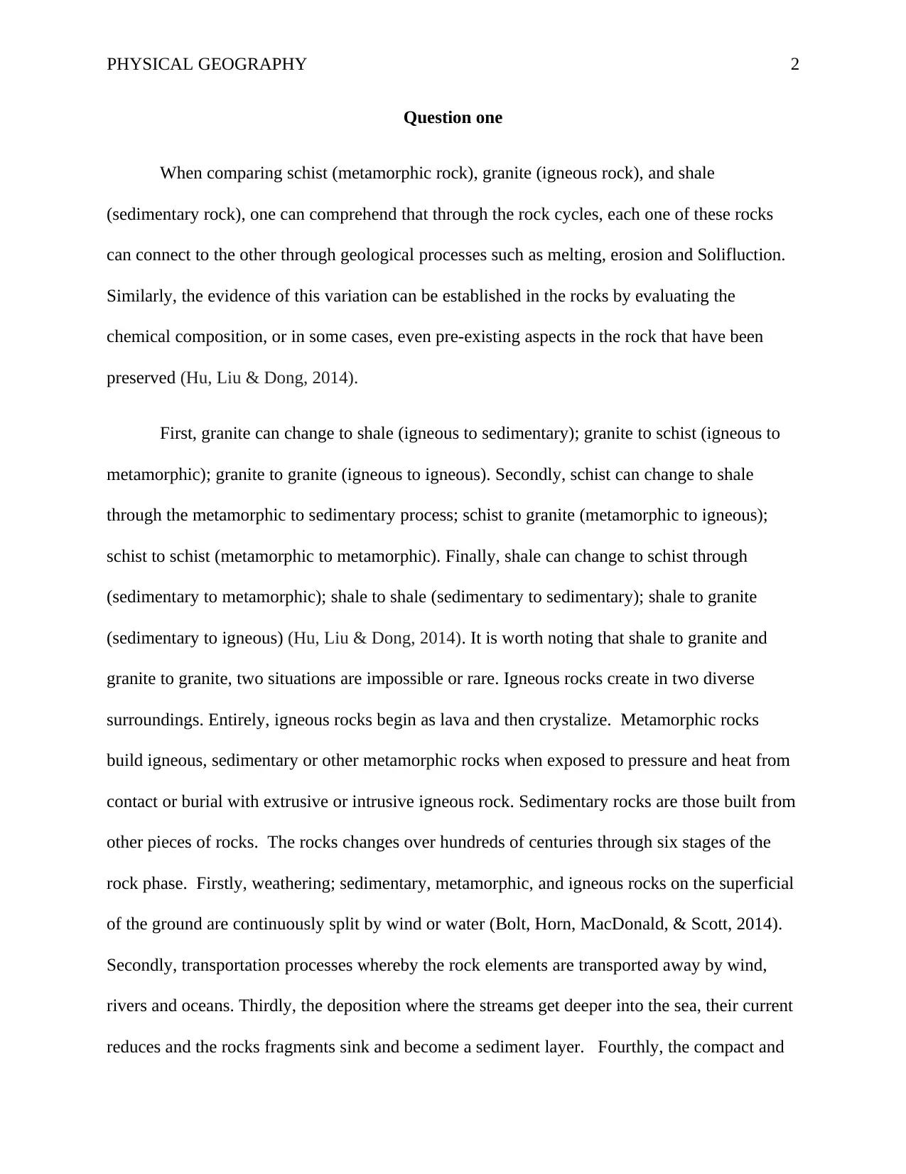
other pieces of rocks. The rocks changes over hundreds of centuries through six stages of the
rock phase. Firstly, weathering; sedimentary, metamorphic, and igneous rocks on the superficial
of the ground are continuously split by wind or water (Bolt, Horn, MacDonald, & Scott, 2014).
Secondly, transportation processes whereby the rock elements are transported away by wind,
rivers and oceans. Thirdly, the deposition where the streams get deeper into the sea, their current
reduces and the rocks fragments sink and become a sediment layer. Fourthly, the compact and
Question one
When comparing schist (metamorphic rock), granite (igneous rock), and shale
(sedimentary rock), one can comprehend that through the rock cycles, each one of these rocks
can connect to the other through geological processes such as melting, erosion and Solifluction.
Similarly, the evidence of this variation can be established in the rocks by evaluating the
chemical composition, or in some cases, even pre-existing aspects in the rock that have been
preserved (Hu, Liu & Dong, 2014).
First, granite can change to shale (igneous to sedimentary); granite to schist (igneous to
metamorphic); granite to granite (igneous to igneous). Secondly, schist can change to shale
through the metamorphic to sedimentary process; schist to granite (metamorphic to igneous);
schist to schist (metamorphic to metamorphic). Finally, shale can change to schist through
(sedimentary to metamorphic); shale to shale (sedimentary to sedimentary); shale to granite
(sedimentary to igneous) (Hu, Liu & Dong, 2014). It is worth noting that shale to granite and
granite to granite, two situations are impossible or rare. Igneous rocks create in two diverse
surroundings. Entirely, igneous rocks begin as lava and then crystalize. Metamorphic rocks
build igneous, sedimentary or other metamorphic rocks when exposed to pressure and heat from
contact or burial with extrusive or intrusive igneous rock. Sedimentary rocks are those built from
other pieces of rocks. The rocks changes over hundreds of centuries through six stages of the
rock phase. Firstly, weathering; sedimentary, metamorphic, and igneous rocks on the superficial
of the ground are continuously split by wind or water (Bolt, Horn, MacDonald, & Scott, 2014).
Secondly, transportation processes whereby the rock elements are transported away by wind,
rivers and oceans. Thirdly, the deposition where the streams get deeper into the sea, their current
reduces and the rocks fragments sink and become a sediment layer. Fourthly, the compact and
PHYSICAL GEOGRAPHY 3
cementation; it happens where the layers of sediment stack up, the pressure and weight compact
the bottoms layers. Metamorphism is another step of rock cycle; the igneous or sedimentary rock
end up being submerged deep under the underground because of the tectonic plate movement.
Lastly, rock melting action whereby the metamorphic rock underground melt to become magma.
As the magma cool down, it toughens and develops to an igneous rock. As soon as a novel
igneous rock is created, the courses of weathering and erosion initiate, and the complete cycles
start once more (Hu, Liu & Dong, 2014).
Figure 1: rock cycles (Hu, Liu & Dong, 2014)
⊘ This is a preview!⊘
Do you want full access?
Subscribe today to unlock all pages.
Trusted by 1+ million students worldwide
PHYSICAL GEOGRAPHY 4
Question 2
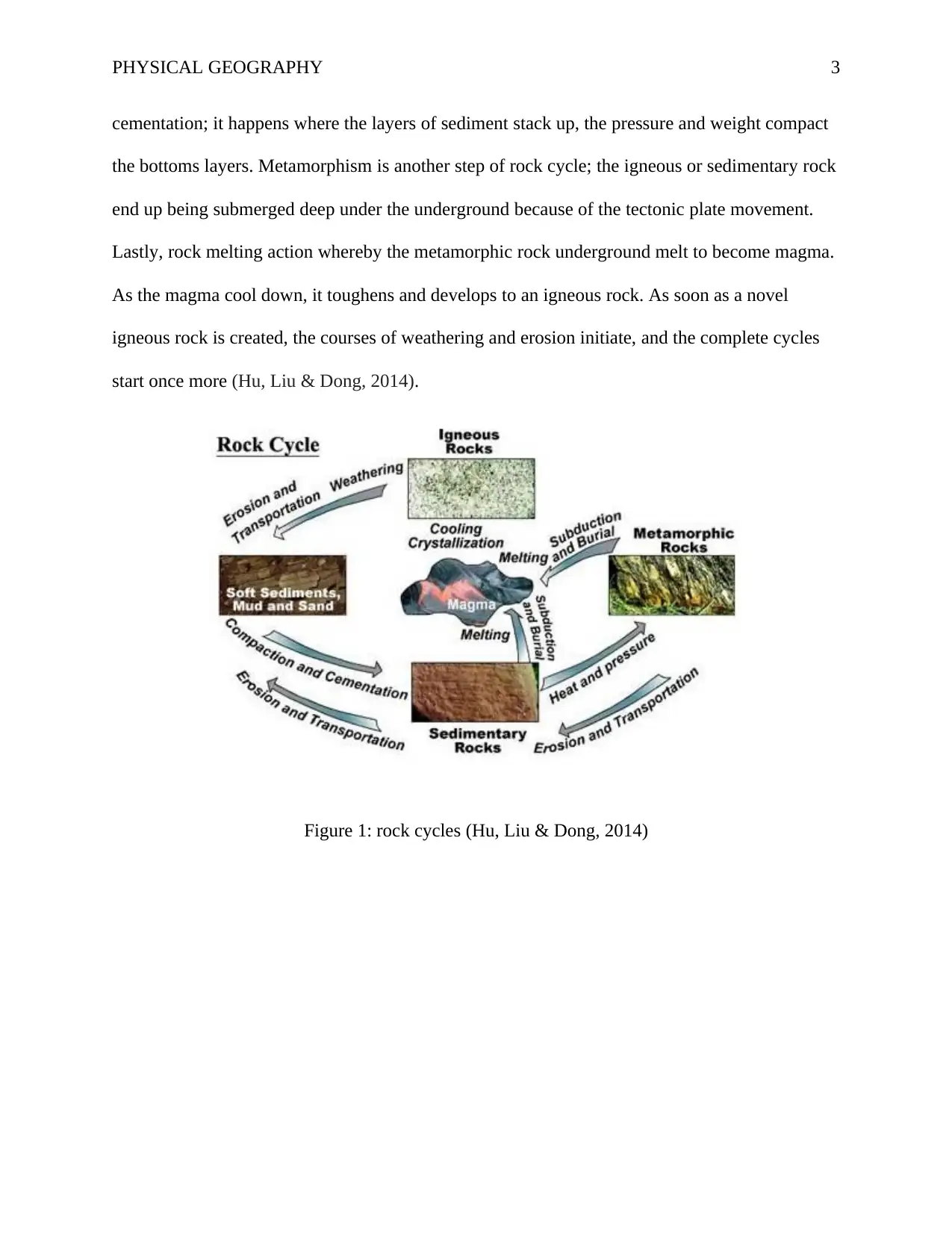
To form a convergent boundary between the plate A and B, then, the plate A must be
from the west and the plate B from the east.
A volcanic arc is positioned on plate D. Therefore, the boundary 3 comprises ocean-
continent convergent boundary. At a convergent plate boundary, when one plate is oceanic, large
volcanoes exist (Hickey & Gottsmann, 2014). These volcanoes are found in lines that outline the
subduction areas and also earthquakes occur in these parts. An oceanic crust may collide with a
continent. The ocean plate is denser, and therefore, it undergoes subduction; meaning that the
oceanic plate sink beneath the continents. As one would expect, where plates collide there are a
lot of intense earthquakes and eruptions of volcanoes (Bolt et al., 2014). The subduction oceanic
plate melts as it reenters the mantle. The magma upsurges and erupts. This generates a volcanic
mountain rage near the coast of the continents. This is range is called continental arc or volcanic
arc (Hickey & Gottsmann, 2014).
The boundary 2 is ocean-ocean convergent boundary which is formed as two ocean plates
collides (plate B moves from west and plate C moves from the east). In this case, the older plate
is denser and therefore, subducts beneath the younger plate. As the subduction plate is pushed
Question 2
To form a convergent boundary between the plate A and B, then, the plate A must be
from the west and the plate B from the east.
A volcanic arc is positioned on plate D. Therefore, the boundary 3 comprises ocean-
continent convergent boundary. At a convergent plate boundary, when one plate is oceanic, large
volcanoes exist (Hickey & Gottsmann, 2014). These volcanoes are found in lines that outline the
subduction areas and also earthquakes occur in these parts. An oceanic crust may collide with a
continent. The ocean plate is denser, and therefore, it undergoes subduction; meaning that the
oceanic plate sink beneath the continents. As one would expect, where plates collide there are a
lot of intense earthquakes and eruptions of volcanoes (Bolt et al., 2014). The subduction oceanic
plate melts as it reenters the mantle. The magma upsurges and erupts. This generates a volcanic
mountain rage near the coast of the continents. This is range is called continental arc or volcanic
arc (Hickey & Gottsmann, 2014).
The boundary 2 is ocean-ocean convergent boundary which is formed as two ocean plates
collides (plate B moves from west and plate C moves from the east). In this case, the older plate
is denser and therefore, subducts beneath the younger plate. As the subduction plate is pushed
Paraphrase This Document
Need a fresh take? Get an instant paraphrase of this document with our AI Paraphraser
PHYSICAL GEOGRAPHY 5
deeper into the layer, it thaws. The lava rises and explodes. These kinds of a line of volcanoes
are recognized as the island arc (Rebetsky, Kuchai & Marinin, 2013).
Question three
Cleveland is a type of stratovolcano found in North America. The stratovolcano is
generally found on top of subduction faults. A stratovolcano key aspect is a huge lava reservoir
in the ground’s crust which generates up over a period (Bolt et al., 2014). This huge lava
reservoir is generated from the melting end of the subduction plate. The volcanic emission of
stratovolcano is formed comparatively gentler by this procedure, so it inclines to be denser,
stocking additional pressure and vapor. This sluggish volcanic course effect causes the retro
between the stratovolcano outbursts to be lengthier. These volcanoes are categorized by a
vertical profile and episodic, fiery eruption. The magma that tides from them is extremely
viscous and chills and toughens before dispersing faraway. The sources of molten rock are
categorized as great in silica to transitional or acidic. This is in distinction to less viscid basic
lava that creates the guard volcanoes, which have an extensive base and more mildly inclined
profile (Hickey & Gottsmann, 2014).
These volcanoes have placid lower inclines but much sharper upper angles, building an
upwardly concave pinecone and typically have numerous distinct outlets. The summit hollow of
these volcanoes is normally trivial. In spite of their contour, there are some differences due to
numerous conformation and sorts of outbursts. The stratovolcano typically takes tens of
thousands and several hundred thousand years to build. Most of them that are presently active are
less than 100,000 years old but some are older, possibly over a million (Hickey & Gottsmann,
2014).
PHYSICAL GEOGRAPHY 6
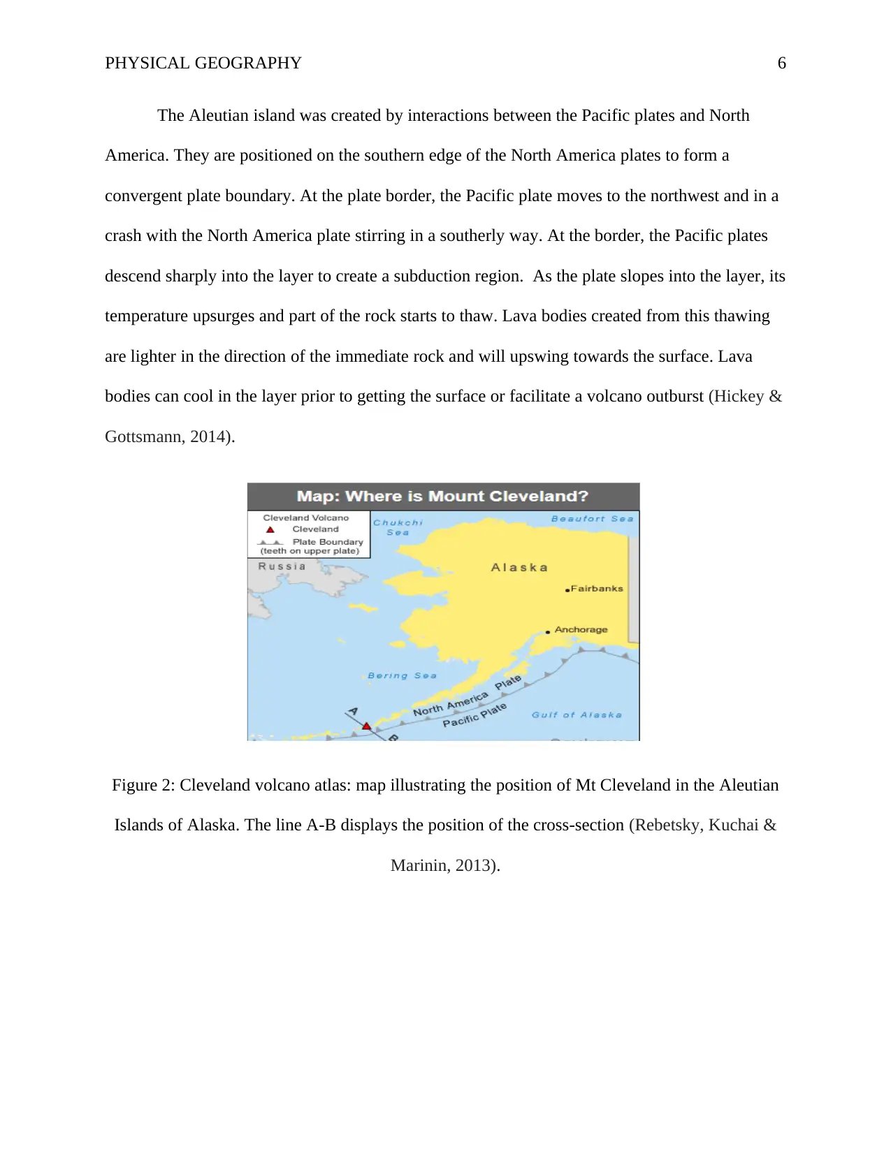
The Aleutian island was created by interactions between the Pacific plates and North
America. They are positioned on the southern edge of the North America plates to form a
convergent plate boundary. At the plate border, the Pacific plate moves to the northwest and in a
crash with the North America plate stirring in a southerly way. At the border, the Pacific plates
descend sharply into the layer to create a subduction region. As the plate slopes into the layer, its
temperature upsurges and part of the rock starts to thaw. Lava bodies created from this thawing
are lighter in the direction of the immediate rock and will upswing towards the surface. Lava
bodies can cool in the layer prior to getting the surface or facilitate a volcano outburst (Hickey &
Gottsmann, 2014).
Figure 2: Cleveland volcano atlas: map illustrating the position of Mt Cleveland in the Aleutian
Islands of Alaska. The line A-B displays the position of the cross-section (Rebetsky, Kuchai &
Marinin, 2013).
⊘ This is a preview!⊘
Do you want full access?
Subscribe today to unlock all pages.
Trusted by 1+ million students worldwide
PHYSICAL GEOGRAPHY 7
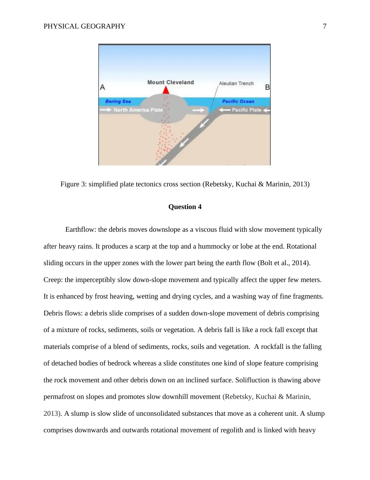
Figure 3: simplified plate tectonics cross section (Rebetsky, Kuchai & Marinin, 2013)
Question 4
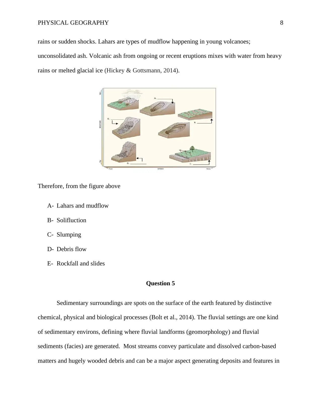
Earthflow: the debris moves downslope as a viscous fluid with slow movement typically
after heavy rains. It produces a scarp at the top and a hummocky or lobe at the end. Rotational
sliding occurs in the upper zones with the lower part being the earth flow (Bolt et al., 2014).
Creep: the imperceptibly slow down-slope movement and typically affect the upper few meters.
It is enhanced by frost heaving, wetting and drying cycles, and a washing way of fine fragments.
Debris flows: a debris slide comprises of a sudden down-slope movement of debris comprising
of a mixture of rocks, sediments, soils or vegetation. A debris fall is like a rock fall except that
materials comprise of a blend of sediments, rocks, soils and vegetation. A rockfall is the falling
of detached bodies of bedrock whereas a slide constitutes one kind of slope feature comprising
the rock movement and other debris down on an inclined surface. Solifluction is thawing above
permafrost on slopes and promotes slow downhill movement (Rebetsky, Kuchai & Marinin,
2013). A slump is slow slide of unconsolidated substances that move as a coherent unit. A slump
comprises downwards and outwards rotational movement of regolith and is linked with heavy
Figure 3: simplified plate tectonics cross section (Rebetsky, Kuchai & Marinin, 2013)
Question 4
Earthflow: the debris moves downslope as a viscous fluid with slow movement typically
after heavy rains. It produces a scarp at the top and a hummocky or lobe at the end. Rotational
sliding occurs in the upper zones with the lower part being the earth flow (Bolt et al., 2014).
Creep: the imperceptibly slow down-slope movement and typically affect the upper few meters.
It is enhanced by frost heaving, wetting and drying cycles, and a washing way of fine fragments.
Debris flows: a debris slide comprises of a sudden down-slope movement of debris comprising
of a mixture of rocks, sediments, soils or vegetation. A debris fall is like a rock fall except that
materials comprise of a blend of sediments, rocks, soils and vegetation. A rockfall is the falling
of detached bodies of bedrock whereas a slide constitutes one kind of slope feature comprising
the rock movement and other debris down on an inclined surface. Solifluction is thawing above
permafrost on slopes and promotes slow downhill movement (Rebetsky, Kuchai & Marinin,
2013). A slump is slow slide of unconsolidated substances that move as a coherent unit. A slump
comprises downwards and outwards rotational movement of regolith and is linked with heavy
Paraphrase This Document
Need a fresh take? Get an instant paraphrase of this document with our AI Paraphraser
PHYSICAL GEOGRAPHY 8
rains or sudden shocks. Lahars are types of mudflow happening in young volcanoes;
unconsolidated ash. Volcanic ash from ongoing or recent eruptions mixes with water from heavy
rains or melted glacial ice (Hickey & Gottsmann, 2014).
Therefore, from the figure above
A- Lahars and mudflow
B- Solifluction
C- Slumping
D- Debris flow
E- Rockfall and slides
Question 5
Sedimentary surroundings are spots on the surface of the earth featured by distinctive
chemical, physical and biological processes (Bolt et al., 2014). The fluvial settings are one kind
of sedimentary environs, defining where fluvial landforms (geomorphology) and fluvial
sediments (facies) are generated. Most streams convey particulate and dissolved carbon-based
matters and hugely wooded debris and can be a major aspect generating deposits and features in
PHYSICAL GEOGRAPHY 9
streams such as fluvial bars downstream of deadlocks. As the river flows across the land, it
erodes the soils and creates banks. A cut bank is also referred to as a river cliff or a river-cut cliff
and is a bank that is closely vertical. Cut banks are found on the outside of a river bend. Cut
banks are caused by the moving water wearing away the earth (Bolt et al., 2014). On the other
hand, point bar is positioned on the inside of a river bend. As the river curves around the river
bend, the water slows down and sediment is dropped to a river bed. Over a period, this sediment
creates up and generates a point bar. A point bar that has been created recently has the same
conformation as a point bar that was made millions of years ago (Hu, Liu & Dong, 2014).
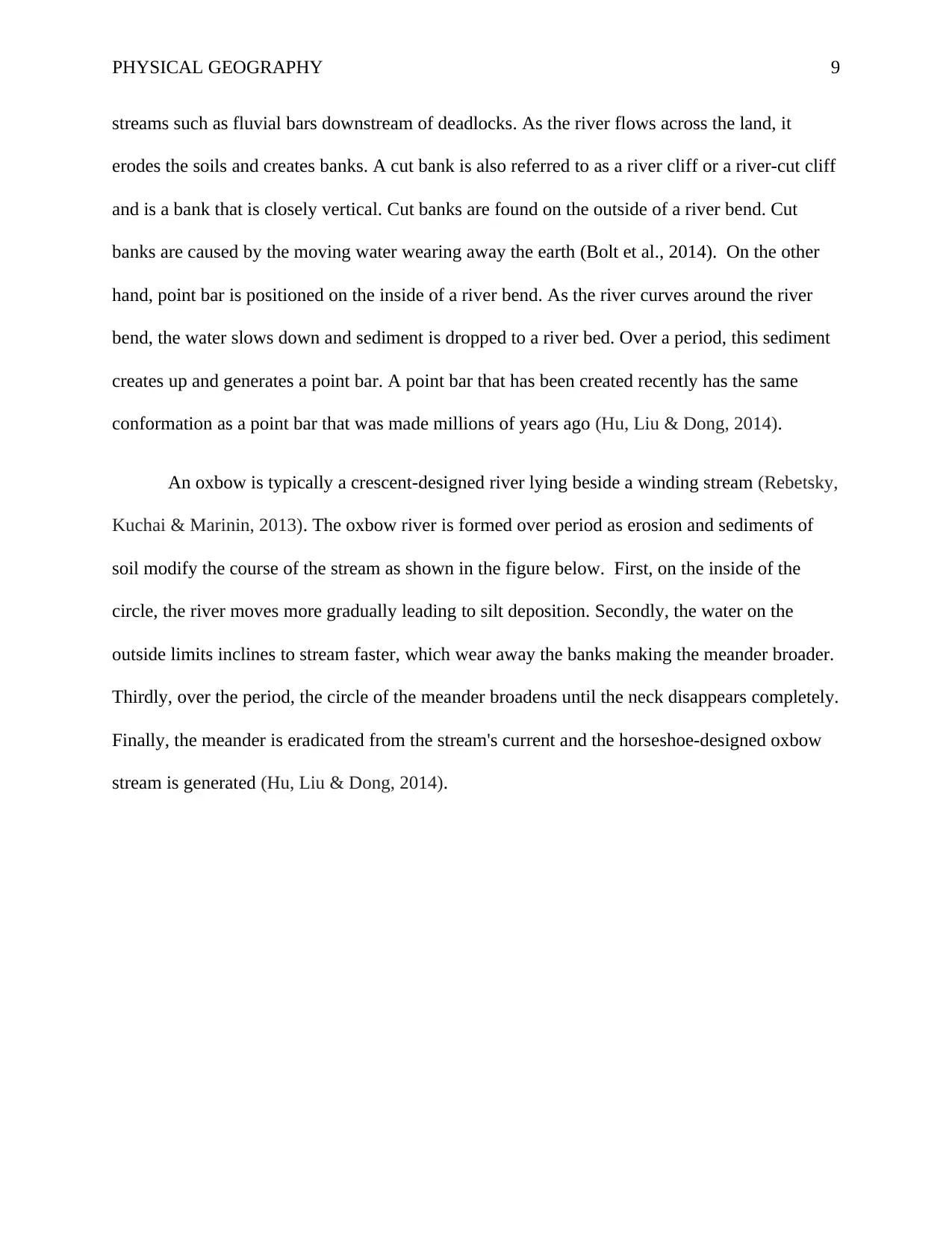
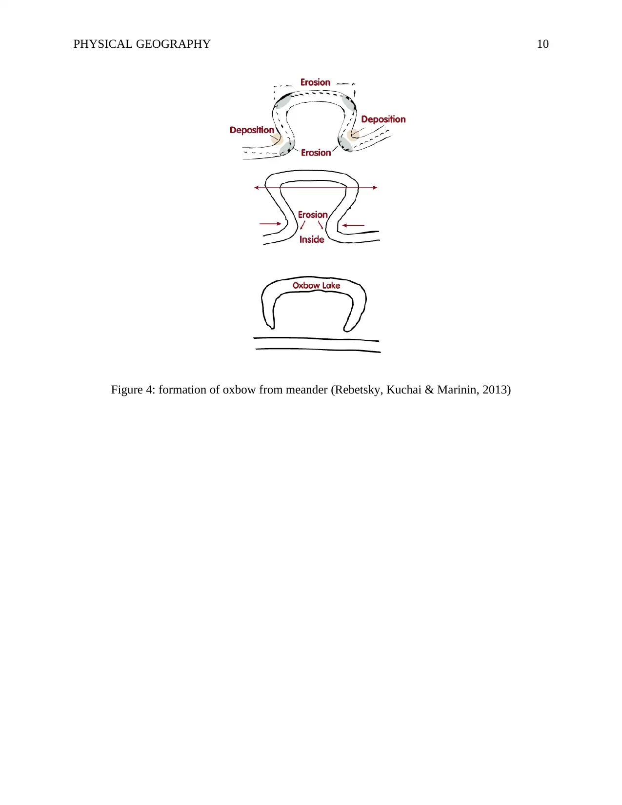
An oxbow is typically a crescent-designed river lying beside a winding stream (Rebetsky,
Kuchai & Marinin, 2013). The oxbow river is formed over period as erosion and sediments of
soil modify the course of the stream as shown in the figure below. First, on the inside of the
circle, the river moves more gradually leading to silt deposition. Secondly, the water on the
outside limits inclines to stream faster, which wear away the banks making the meander broader.
Thirdly, over the period, the circle of the meander broadens until the neck disappears completely.
Finally, the meander is eradicated from the stream's current and the horseshoe-designed oxbow
stream is generated (Hu, Liu & Dong, 2014).
streams such as fluvial bars downstream of deadlocks. As the river flows across the land, it
erodes the soils and creates banks. A cut bank is also referred to as a river cliff or a river-cut cliff
and is a bank that is closely vertical. Cut banks are found on the outside of a river bend. Cut
banks are caused by the moving water wearing away the earth (Bolt et al., 2014). On the other
hand, point bar is positioned on the inside of a river bend. As the river curves around the river
bend, the water slows down and sediment is dropped to a river bed. Over a period, this sediment
creates up and generates a point bar. A point bar that has been created recently has the same
conformation as a point bar that was made millions of years ago (Hu, Liu & Dong, 2014).
An oxbow is typically a crescent-designed river lying beside a winding stream (Rebetsky,
Kuchai & Marinin, 2013). The oxbow river is formed over period as erosion and sediments of
soil modify the course of the stream as shown in the figure below. First, on the inside of the
circle, the river moves more gradually leading to silt deposition. Secondly, the water on the
outside limits inclines to stream faster, which wear away the banks making the meander broader.
Thirdly, over the period, the circle of the meander broadens until the neck disappears completely.
Finally, the meander is eradicated from the stream's current and the horseshoe-designed oxbow
stream is generated (Hu, Liu & Dong, 2014).
⊘ This is a preview!⊘
Do you want full access?
Subscribe today to unlock all pages.
Trusted by 1+ million students worldwide
PHYSICAL GEOGRAPHY 10
Figure 4: formation of oxbow from meander (Rebetsky, Kuchai & Marinin, 2013)
Figure 4: formation of oxbow from meander (Rebetsky, Kuchai & Marinin, 2013)
Paraphrase This Document
Need a fresh take? Get an instant paraphrase of this document with our AI Paraphraser
PHYSICAL GEOGRAPHY 11
References
Bolt, B. A., Horn, W. L., MacDonald, G. A., & Scott, R. F. (2014). Geological Hazards:
Earthquakes -- Tsunamis -- Volcanoes, Avalanches -- Landslides -- Floods. Berlin:
Springer Berlin.1st ed. [Online]. Retrieved from:https://books.google.com/books?
hl=en&lr=&id=7qffBwAAQBAJ&oi=fnd&pg=PR1&dq=causes+of+earthquakes&ots=F
cGx6mqN94&sig=lSgmpAjIxz8ytXnmXitb0UYri3w, [Accessed on 30 October 2018].
Hickey, J., & Gottsmann, J. (2014). Benchmarking and developing numerical Finite Element
models of volcanic deformation. Journal of Volcanology and Geothermal Research, 280,
126-130. [Online]. Retrieved from:
https://www.sciencedirect.com/science/article/pii/S037702731400153X, [Accessed on 30
October 2018].
Hu, Y. X., Liu, S. C., & Dong, W. (2014). Earthquake engineering. CRC Press.1st ed. [Online].
Retrieved from: https://www.taylorfrancis.com/books/9781482271645, [Accessed on 30
October 2018].
Rebetsky, Y. L., Kuchai, O. A., & Marinin, A. V. (2013). Stress state and deformation of the
Earth’s crust in the Altai–Sayan mountain region. Russian Geology and
Geophysics, 54(2), 206-222. [Online]. Retrieved from:
https://www.researchgate.net/profile/Yu_Rebetsky/publication/257480743_Stress_state_
and_deformation_of_the_Earth%27s_crust_in_the_Altai-Sayan_mountain_region/links/
5a31f9a50f7e9b2a28d5ceed/Stress-state-and-deformation-of-the-Earths-crust-in-the-
Altai-Sayan-mountain-region.pdf, [Accessed on 30 October 2018].

PHYSICAL GEOGRAPHY 12
⊘ This is a preview!⊘
Do you want full access?
Subscribe today to unlock all pages.
Trusted by 1+ million students worldwide
1 out of 12

Your All-in-One AI-Powered Toolkit for Academic Success.
+13062052269
info@desklib.com
Available 24*7 on WhatsApp / Email
![[object Object]](/_next/static/media/star-bottom.7253800d.svg)
Unlock your academic potential
Copyright © 2020–2026 A2Z Services. All Rights Reserved. Developed and managed by ZUCOL.