Sediment Analysis: Impact on Saskatchewan River Geomorphology
VerifiedAdded on 2022/09/27
|14
|3045
|18
Report
AI Summary
This research report investigates the effects of sediment on the Saskatchewan River Basin, focusing on its geomorphological impact and the influence of human activities. The study examines the temporal and spatial variability of suspended sediments, analyzing data from 23 monitoring stations to understand sediment yield patterns and their relationship to factors such as climate, land use, and topography. The report highlights the impact of the EB Campbell Dam on sediment transport and the subsequent changes in the delta. The findings reveal variations in sediment concentrations and loads across the basin, with implications for the river's geomorphology and ecosystem. The analysis also addresses the challenges in data collection and standardization, providing insights into the long-term sediment dynamics of the Saskatchewan River Basin and the limitations in sediment supply to the delta. The report concludes by discussing the importance of considering sediment limitations for the ecological health of the delta and the communities that depend on it.
RESEARCH REPORT
By Name
Course
Instructor
Institution
Location
Date
By Name
Course
Instructor
Institution
Location
Date
Paraphrase This Document
Need a fresh take? Get an instant paraphrase of this document with our AI Paraphraser
Contents
ABSTRACT....................................................................................................................................................2
INTRODUCTION...........................................................................................................................................3
OBJECTIVES..................................................................................................................................................4
LITERATURE REVIEW....................................................................................................................................4
The annual yield of the sediment............................................................................................................4
METHODOLOGY...........................................................................................................................................6
RESULTS AND DISCUSSION..........................................................................................................................6
CONCLUSION...............................................................................................................................................9
REFERENCES..............................................................................................................................................11
ABSTRACT
The suspended sediments and their spatial as well as variability which are temporary have had
their reports shared in different units in the entire region. There are various research works which
have focused on the valuation of the land use, climate, basin area as well as topography which
have been used in the prediction of long- term fluvial rates of denudation as well as in the
assessments of human activities. The characteristics of the suspended sediments transport of
streams in the Saskatchewan River basin showed considerable variation across the entire basin.
These variations ranged from one location to another in the downstream as a result of variations
in the physiography, geology, drainage area and hydrological regime. It was not possible to have
a direct comparable estimate between stations. This was due to the differences in the period and
length of the records. The mean yearly sediment increased downstream along the river
⊘ This is a preview!⊘
Do you want full access?
Subscribe today to unlock all pages.
Trusted by 1+ million students worldwide
Saskatchewan Plains. In particular, the paper has presented analysis of the sediment impacts on
the Saskatchewan River basin geomorphology.
INTRODUCTION
The loads of the suspended sediments and their spatial as well as temporal variability have been
reported at a variety of scales from various parts of the world. Various studies of the influence of
climate, land use, basin area, and topography have sought to be used in the prediction of long-
term fluvial rates of denudation as well as in the assessments of human activities. It is interesting
to note that the temporal aspect of the transportation of suspended sediments incorporates inters
and intrabasin contrasts in the time of transportation of the sediments has received very little
attention (Gober & Wheater 2014).
The pattern of the region sediment yields ion Canada was summarized for the first in the year
1973. Some of the most recent summaries of the data on suspended sediments have been
Paraphrase This Document
Need a fresh take? Get an instant paraphrase of this document with our AI Paraphraser
gathered via specific surveys in Canada concerning water before production in various
publications in some days back. This particular paper has summarized the patterns of long-term
suspended yield and load while considering different magnitude and regime. The characteristics
of the suspended sediments between the year 1988 and 2019 have been analyzed for by this piece
of this literature. The project is analyzing the amount of sediment present downstream and how it
impacts the river Saskatchewan geomorphology.
The changing periods and lengths of the gathered records have acted as source of hindrance to
the proper analysis of the patterns above. There was a lot of sacrifice in reducing the records to
common periods between various stations o the sediments. Such reduction considerably affected
the precision and the accuracy of the load sediment estimates. It is important to note that it has
never been easy to obtain the yearly man sediment load within the duration recorded in the
respective locations. The difficulties were due to the fact that some cases had their data obtained
in the season commonly refered to as open water window period.
OBJECTIVES
The projects aims at analyzing the amount of sediment present downstream and how it impacts
the river Saskatchewan geomorphology.
LITERATURE REVIEW
It has been estimated that an area of about 363000 square kilometers is drained by river
Saskatchewan to Lake Winnipeg from the continental divide. Some of the natural lakes are found
along the streams within this basin on the extreme section of northeastern and Cumberland Delta.
This includes the areas which borders Canada’s shield. Also reservoirs exist along the profile of
such stream including Lake Tobin and Diefenbaker Lake This has influenced the regime of flow
of the rivers. They have been identified as important traps of the sediments. The physiographic
comparison between Rocky Mountains and Alberta - Saskatchewan plain involves considering
basin’s western margin with the foothills which has been important because of the associated
differences in the runoff and precipitation. The other categories include, Bow River, Deer River
and Oldman River in western Alberta which constitutes almost 70% of the mean annual flow as
far as e Saskatchewan is concerned.
Sediment of Annual Yield
The mean calculation of the annual yield of sediment which constitutes the load have been in
consideration with the unit area in most of Prairie drainage basin when complicated using similar
availability of larger regions with system of drainage internally. Therefore, it is contributing to
difficulties on deciding on the effective measurement of area of drainage. The drainage that is
covered internally consists of both huge flow system having numerous thousand square
kilometer and even myriad small hollows depression as well as sloughs.
The internally drained land area which is referred as the area of the dead drainage upstream
every Canada’s survey of water that is reflected from the data gauge measurement from 1: 50000
.The measurements are shown in the maps of topographic as per the Prairie Farm Rehabilitation
Administration. By subtraction evaluation of the entire place of drainage in the divide drainage,
the effective result area which gives the estimation of the contributing runoff area, thus connect
partially to the contribution of sediment from the main system of the drainage.
The whole area has been considered in the sediment yield calculations but in most cases the lake
upstream drainage area as well as well as reservoirs is subtracted. Therefore, the calculation of
the drainage area is done in consideration of these adjustments which are referred as the area of
potential sedimentary contributing. The Prairie basins yields are more as compared with the
⊘ This is a preview!⊘
Do you want full access?
Subscribe today to unlock all pages.
Trusted by 1+ million students worldwide
basin data without a large drainage area internally if calculated using this method as compared to
the calculation using the total drainage area. Therefore, it should note that the sediment data
absence in the northern Saskatchewan River located in between the Prince Albert and whirlpool
meaning that a lot of discussion sediment yield variation is mostly applies to the South
Saskatchewan River basin.
The general tendency of the smaller basins of headwater within the Rocky Mountains as well as
foothills thus giving a lower yield though the yield increase downstream of the larger basin with
the Alberta plains.
METHODOLOGY
The study involved review of the exiting literature sources on the routinely collected samples of
suspended sediments. These samples were collected by the use of United States Geological
Survey. It is approximated that 112 location points or stations are found within River
Saskatchewan basin. It is from these locations that samples for study analysis were collected. It
is important to note that only about 25% of the locations were found to be active in a certain
year. The paper has concentrated on 23 stations that have very long-term records. Their
establishments were as per the listed figure below (Wishingrad et al.2014). The areas of the
drainage ranged from 10 to over 300 000 km2. The processes of sampling at such stations
extended either the whole area or during the seasons of open water which is from March to
October.
The collection of the samples was done few days during the average conditions of the flow and
more frequently during the events of the flood. There was hand interpolation between the
samples using a continuous plot. It is through this approach that daily mean load and
Paraphrase This Document
Need a fresh take? Get an instant paraphrase of this document with our AI Paraphraser
concentration were calculated. This particular method has been different from the technique of
curve rating that has been commonly used in the studies of sediment yield (Lunt et al.2013).
RESULTS AND DISCUSSION
In contrast most of the sections of stream section of Saskatchewan River basin experiences both
summer and spring peak loads periods as for the case of the longer duration. In addition to this
effect, there is likelihood of having more affected by intense storm which will cover limited
areas. Some of the expected impacts of the variations within the flow affects the amount as well
as number of occurrence of properties of the transported sediments. As can be seen from the
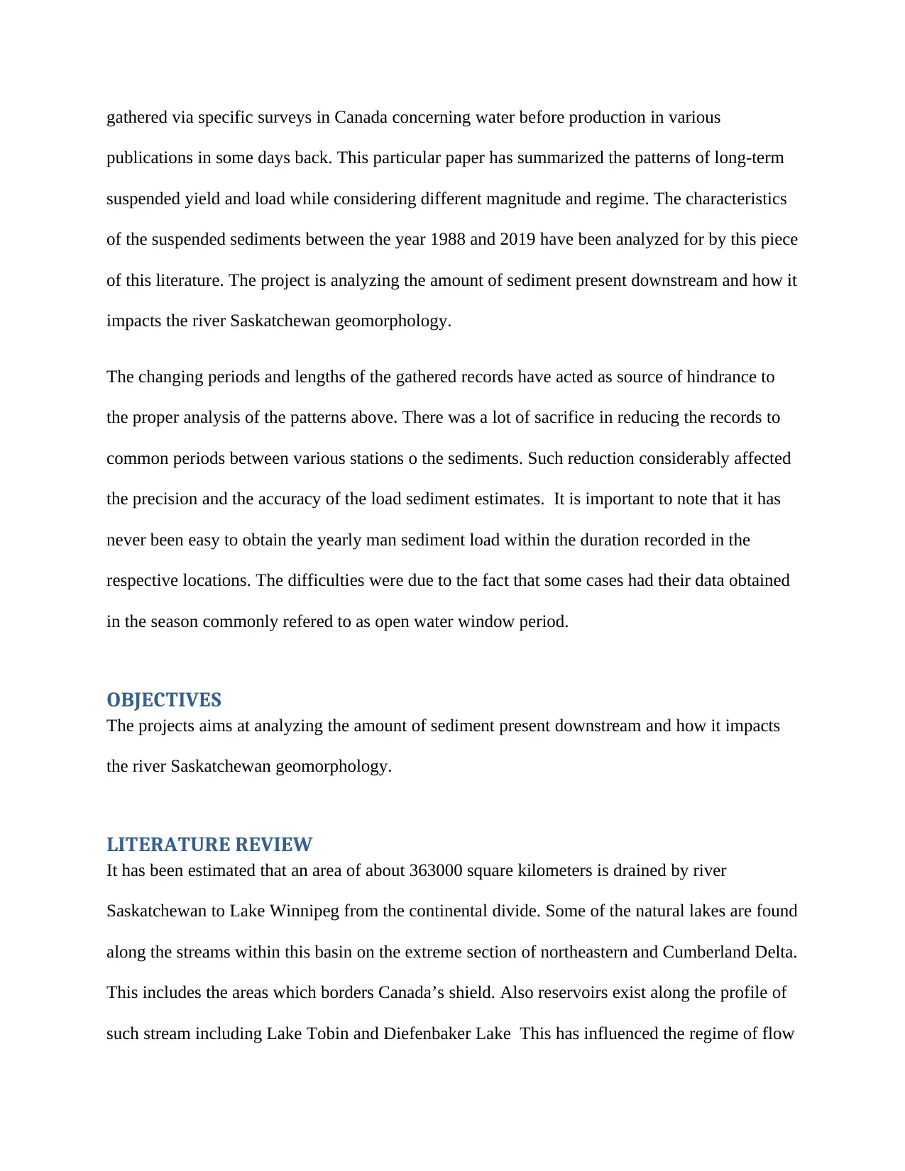
elaborated graphical work, the percentage of seasonal loading is approximated to be 1% as for
the plotted time against the dispersion. From the graph there was a typical correlation between
the load transported seasonally within one percent as well as skewness and dispersion curve
which illustrates the flow-time connection. The coefficients of the correlation for dispersion and
skewness were found to be 0.787 and 0.605 respectively. In both cases, there was excess of 0.01
levels of significant measurements.
These differences were presumably taken as the discharge and flow regime period and may
subsequently relate to the area of drainage. This is the same as the downstream attenuation of the
curve rating that has been commonly used in the studies of sediment yield (Lunt et al.2013).
RESULTS AND DISCUSSION
In contrast most of the sections of stream section of Saskatchewan River basin experiences both
summer and spring peak loads periods as for the case of the longer duration. In addition to this
effect, there is likelihood of having more affected by intense storm which will cover limited
areas. Some of the expected impacts of the variations within the flow affects the amount as well
as number of occurrence of properties of the transported sediments. As can be seen from the
elaborated graphical work, the percentage of seasonal loading is approximated to be 1% as for
the plotted time against the dispersion. From the graph there was a typical correlation between
the load transported seasonally within one percent as well as skewness and dispersion curve
which illustrates the flow-time connection. The coefficients of the correlation for dispersion and
skewness were found to be 0.787 and 0.605 respectively. In both cases, there was excess of 0.01
levels of significant measurements.
These differences were presumably taken as the discharge and flow regime period and may
subsequently relate to the area of drainage. This is the same as the downstream attenuation of the
waves of the flood which tend to come from highly raised grounds down to lowlands of
Saskatchewan. Others will include physical characteristics as well as drainage which is under th
influence of topography. The source area characteristics and sediment delivery were considered
to be worth consideration. The explanation for differences in temporal sediment transportation
pattern in such terms weighed beyond the scope of this particular project and hence became
important for similar future studies (Masud, Khaliq & Wheater 2015).
From the obtained data, it was possible to have other options to b used in standardization of the
loads for specific sediments which are generated by the river with a defined system of drainage.
This will be in line with the average yearly drainage. The mean yearly load ratio to mean yearly
volume of flow directly impact on the concentration of the sediments hence refered to as average
annual concentration (Pomeroy, Stewart, & Whitfield 2016).
The slightly low concentrations comparison between the Foothill streams and mountains indicate
the same. In the case of the Alberta plains portions the concentration is high leading to reduction
in the sediments suspended in terms of concentration at the Bow River at Calgary. This is in the
south of Saskatchewan River at katoon on the location of (05HG001). Also the area around
Saskatchewan River downstream within the Tobin Lake registered high concentration. The level
of the concentration was found to be relatively reduced within Saskatchewan discharge
downstream specifically within the point of Whirlpool.
The obtained results have contradicted the recorded yield which remained to be high within the
site. This was attributed to the glacially dominated regime of the flow at the same station. The
obtained results did not show any significant variation from the available previous summary as
per the annual concentrations. The available details of the river Saskatchewan concentration
⊘ This is a preview!⊘
Do you want full access?
Subscribe today to unlock all pages.
Trusted by 1+ million students worldwide
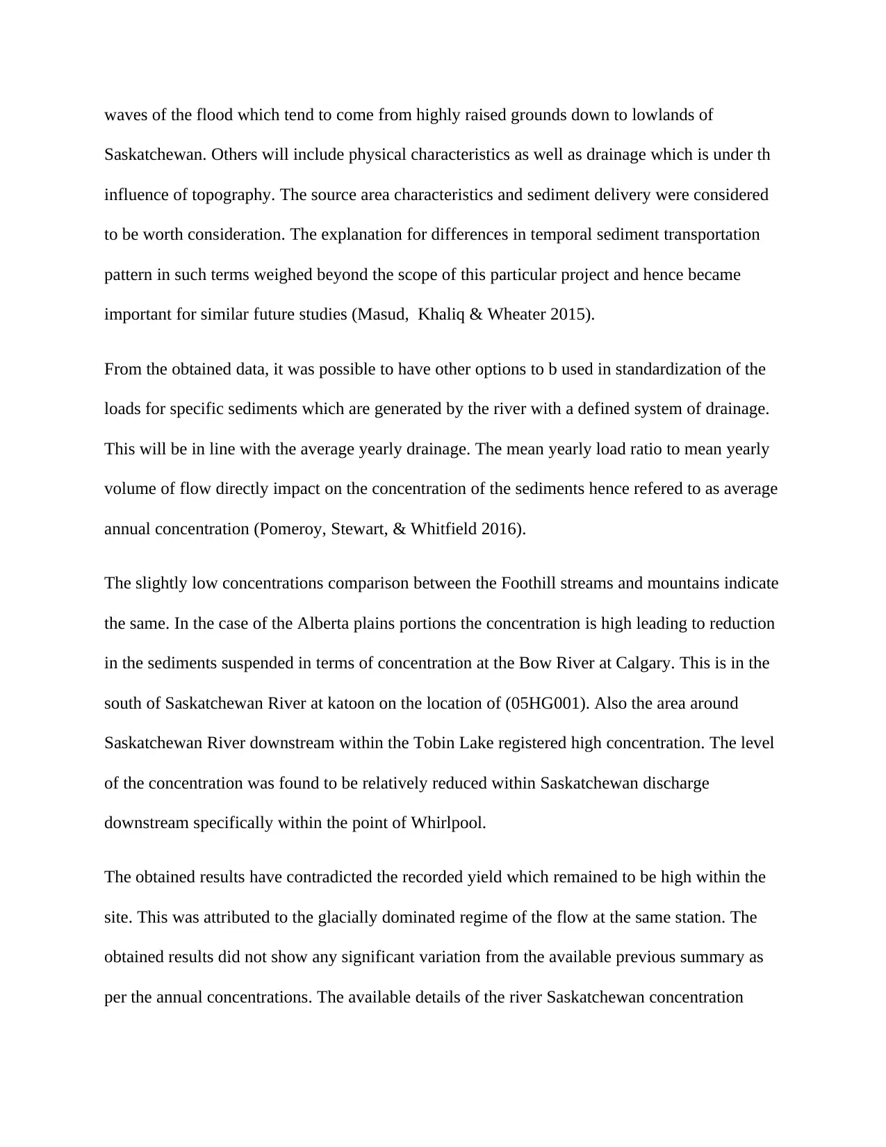
were found to be 1000 mg L-'. This occurred in the specific portion of the Red Deer River
downstream of Oldman River. This was different from the one which had been shown from the
mapped areas (Hipel, Fang, & Wang 2013).
Lake Tobin is found in the upstream of EB Campbell. This was the reservoir which was formed
during the construction of EB Campbell. The comparison of the Ashmore and Day comparison
from the year 1988 to 2019 gives loads as 0.111*10^6 tonnes in the year 2019 from 0.092*10^6
tonnes that was recorded in the year 1988. The variation or the difference between these two
digits is approximately 16000 tonnes (North et al 2015). Despite the fact this kind of variation is
equivalent to 16000 tonnes, the value is significant as per the registered errors in the day to day
measurements and conditions of the flow. The variation of 16000 tonnes is very small when
compared with other differences between the downstream and upstream as per the calculation.
The figures obtained from the analysis are an indication that even very small amount of the size
of the sample can come up with the same estimate as for 30 years ago. Ideally not much has
changed as per the results. Also from the results, it is evident that below the dam there have been
very little activities taking place meaning nothing has been left to be eroded from the bottom of
Paraphrase This Document
Need a fresh take? Get an instant paraphrase of this document with our AI Paraphraser
the river. In the lower sections of the downstream especially the Big Eddy Camp where there
was location of continuous monitoring, there was higher TSS an indication of very active
processes of erosion (Hassanzadeh et al.2015).
CONCLUSION
The characteristics of the suspended sediments transport within Saskatchewan River basin have
shown various changes along the stream of the basin. These variations ranged from one location
to another in the downstream as a result of variations in the physiography, geology, drainage area
and hydrological regime. It was not possible to have a direct comparable estimate between
stations (Akomeah et al 2015). This was due to the differences in the period and length of the
records. The mean yearly sediment increased downstream along the river Saskatchewan Plains.
This implied that the yield of the sediment increased as the drainage area in the streams
increased. This was in contrary to the pattern that has been observed in most of the small basins.
Due to the overriding influence on the variations of geology as well as physiography, the
variations were recorded in the mountains and plains (Ball, Noble & Dubé 2013).
The skewness and dispersion of the daily yield takes into consideration the concentration and
duration s covered in the curves. These are the same basins that have portrayed the most skewed
loads cumulatively. This has been again demonstrated in the case of the duration curves that have
again portrayed high magnitude events. Proper explanation of the variations in the spatial and
temporal characteristics of the yields of the sediments may only be obtained by having
comparisons of the hydrological features. In the extreme cases, the understanding can be
enhanced by having improved link between the source areas and delivery processes and stream-
borne sediments.
REFERENCES
Akomeah, E., Chun, K. P., & Lindenschmidt, K. E. (2015). Dynamic water quality modelling
and uncertainty analysis of phytoplankton and nutrient cycles for the upper South
Saskatchewan River. Environmental Science and Pollution Research, 22(22), 18239-
18251.
Ball, M. A., Noble, B. F., & Dubé, M. G. (2013). Valued ecosystem components for watershed
cumulative effects: an analysis of environmental impact assessments in the South
Saskatchewan River watershed, Canada. Integrated environmental assessment and
management, 9(3), 469-479.
Gober, P., & Wheater, H. S. (2014). Socio-hydrology and the science–policy interface: a case
study of the Saskatchewan River basin. Hydrology and Earth System Sciences, 18(4),
1413-1422.
⊘ This is a preview!⊘
Do you want full access?
Subscribe today to unlock all pages.
Trusted by 1+ million students worldwide
1 out of 14
Your All-in-One AI-Powered Toolkit for Academic Success.
+13062052269
info@desklib.com
Available 24*7 on WhatsApp / Email
![[object Object]](/_next/static/media/star-bottom.7253800d.svg)
Unlock your academic potential
Copyright © 2020–2026 A2Z Services. All Rights Reserved. Developed and managed by ZUCOL.