Spatial Data Supply Chain Provenance Modelling Dissertation
VerifiedAdded on 2022/10/12
|36
|9431
|115
Thesis and Dissertation
AI Summary
This dissertation investigates spatial data supply chain (SDSC) provenance modeling using semantic web technologies. It addresses contemporary challenges in spatial information management, particularly in the context of fourth-generation industrial revolutions and next-generation spatial infrastructures. The research emphasizes the need for provenance to ensure data trust, quality, and fitness for purpose within SDSCs, which involve heterogeneous geo-processes. The study explores the application of semantic web technologies, including ontologies, to capture and represent spatial data provenance at various levels, from datasets to individual features. The work highlights the importance of provenance in assessing data quality, tracking workflows, and enabling data reuse. The dissertation also discusses the integration of geospatial data from diverse sources, addressing issues of semantic heterogeneity and the need for standardized metadata. The findings demonstrate the feasibility and necessity of incorporating provenance into Geographic Information Systems (GIS) to enhance user confidence and facilitate effective spatial data management and analysis. The study explores the application of W3C provenance to address geospatial data provenance at different levels. Furthermore, the dissertation aims to contribute to improved organization, access, and utilization of spatial data within Australia and New Zealand.
Spatial Data Supply Chain Provenance
Modelling using Semantic Web
Technologies
Name
Department
University
This dissertation is submitted for the degree of
Doctor of Philosophy
1 | P a g e
Modelling using Semantic Web
Technologies
Name
Department
University
This dissertation is submitted for the degree of
Doctor of Philosophy
1 | P a g e
Paraphrase This Document
Need a fresh take? Get an instant paraphrase of this document with our AI Paraphraser

Dedication
I would like to dedicate this thesis to my loving parents …
2 | P a g e
I would like to dedicate this thesis to my loving parents …
2 | P a g e

Declaration
I hereby declare that except where specific reference is made to the work of others, the contents of this
dissertation are original and have not been submitted in whole or in part for consideration for any other
degree or qualification in this, or any other University. This dissertation is the result of my work and
includes nothing which is the outcome of work done in collaboration, except where specifically indicated
in the text. This dissertation contains less than words including appendices, bibliography, footnotes,
tables and equations and has less than figures.
Name
2019
3 | P a g e
⊘ This is a preview!⊘
Do you want full access?
Subscribe today to unlock all pages.
Trusted by 1+ million students worldwide

Acknowledgements
And I would like to acknowledge ...
4 | P a g e
And I would like to acknowledge ...
4 | P a g e
Paraphrase This Document
Need a fresh take? Get an instant paraphrase of this document with our AI Paraphraser

List of Figures and Abbreviation
5 | P a g e
5 | P a g e
Contents
1 Introduction
Introduction............................................................................................................
Theory
Systems of Geospatial Data Sharing..............................................................................
Semantic web technologies............................................................................................
Provenance for spatial analysis……………………………………………………………….
Objective
2 Development of ontologies
What is in an ontology....................................................................................................
Why develop an ontology...............................................................................................
Defining classes and a class hierarchy...........................................................................
Determine the domain and scope of the ontology..........................................................
Define the classes and the class hierarchy....................................................................
Define the properties of classes—slots...........................................................................
Define the facets of the slots..........................................................................................
Create instances
System Design
3 Data
Spatial data source.........................................................................................................
4 Some Experimental Results
Publish GIS data.............................................................................................................
RDF
RDF Query
5 Discussion
Results Discussion..........................................................................................................
Suggestions....................................................................................................................
6 Conclusions
Objective achievement...................................................................................................
Limitation and suggestion.............................................................................................
Further improvement.....................................................................................................
References
6 | P a g e
⊘ This is a preview!⊘
Do you want full access?
Subscribe today to unlock all pages.
Trusted by 1+ million students worldwide
Abstract:
Geographic Information Systems (GIS) assume a significant job to obtain and convey geospatial
learning dependent on spatial information and the utilization of spatial examination,
demonstrating, and perception. The affirmation of the legitimacy and nature of spatial
information taking care of what's more, examination remains an extraordinary test, to some
degree, due to complex systems are frequently required for collective geospatial critical thinking
and basic leadership. These methods, when indicated as information induction work processes,
require painstakingly designed parameters and spatiotemporal determinations guided by explicit
settings and purposes. The data of spatial information ancestry and related investigation work
process is characterized as spatial provenance in this examination.
Provenance, a metadata fragment insinuating the source and the systems grasped to get a
particular geo-practical propelled component or thing, is urgent to survey the idea of spatial
information and help in imitating and reproducing geospatial structures. Regardless, the
heterogeneity and capriciousness of the geospatial forms, which can modify part of the complete
substance of datasets, clarify the requirement for depicting geospatial provenance at the dataset,
feature and trademark levels. This paper shows the use of W3C provenance, which is a
nonexclusive detail to express provenance records, for addressing geospatial data provenance at
these different levels. erence in the usage of spatial provenance in GIS applications. As a rule,
the building and execution portrayed in the paper show the need, what's more, feasibility of
bringing provenance into GIS.
7 | P a g e
Paraphrase This Document
Need a fresh take? Get an instant paraphrase of this document with our AI Paraphraser
Chapter 1
Introduction:
Geospatial data has gotten expanding consideration from the standard IT world and become
fundamental for different certifiable uses. For example urban arranging, traffic examination and
emergency reaction. In the geospatial network, the exchange, sharing and representation of
geospatial information chiefly depend on various syntactic benchmarks which shape the present
answers for spatial information foundation (SDI). Such norms are chiefly from Open Geospatial
Consortium (OGC), and the vast majority of them just certification on a syntactic level, while the
semantics and information are said to be inadequate. In this way, we need a path for tending to
the semantic difficulties concerning geospatial information and learning [1].
Numerous heritage Geographic Information Systems (GIS) have been created over various
periods, for various purposes, with various structures based on various GIS programming. The
heritage GIS based on various GIS programming has its exclusive designs of system, information
models and database structures of storage. Therefore, databases of geographic-based on these
frameworks can't convey without data transformation. In any case, the transformation of data is
costly and tedious and may prompt the similarity issues for some time-critical approach, which
need continuous access to diverse data on speedy choices and take instantaneous activities [2].
Although the advancement of the World-Wide-Web (WWW) and numerous Internet GIS
provide owner approaches to enable clients to rapidly access, show and inquiry spatial
information over the web. This Internet GIS additionally has the confinements of exclusive
programming plans, information models and storage of database structures.
Issues recognized by Hakimpour and Timpf [3] with data reconciliation between various
frameworks. They portray a few issues identifying with semantic heterogeneity and create
answers to conquering these issues utilizing ontologies to make and institutionalize road join.
They additionally talk about inter-operability issues between various spatial data-set structures
and models and the need to determine semantic heterogeneity for example for similar highlights
in various data-sets gathered by various organizations having various definitions. For instance,
an element class for Main Street may have various definitions as indicated by their motivation
and application in separate offices. A further issue is that information pattern and trait structures
8 | P a g e
and definitions may fluctuate between offices. One arrangement is to formalize the semantics
characterized at the area level and get understanding from all gatherings that partake in its
utilization. What's more, the age of an institutionalized metaphysics made for a particular space
is likewise conceivable. Here a formalization of ideas can be actualized at a more extensive level
with the goal that definitions and understandings of data-sets can be institutionalized.
The significance of investigation into information safeguarding and the need to create
provenance information stores for inquiry and reuse of information in a manner that is viable,
auspicious and with an abnormal state of client certainty and trust [4]. The provenance of
datasets is the wellspring of truth about elements, exercises and individuals, who gather, produce
and add to the datasets. If the historical backdrop of datasets has been set up, the ancestry can be
followed, possession distinguished and in particular, practices and procedure can be broke down
and reused for further experimentation. He features likenesses, clashes and issues with current
provenance models and exercises. A study was done on provenance and a scientific classification
delivered that portrays the constraints due to there being no actualized provenance measures, no
client introduction to provenance data, no devoted stockpiling of provenance data, and no
strategies to display provenance data to a client in a reasonable structure. Suriarachchi [4] also
underlines meaningfulness issues just as the requirement for improved comprehension of
provenance data. He overviewed seven provenance data frameworks, two of which have
provenance perception instruments of some structure, four have no representation at all and one
creates XML records.
During a geospatial web administrations condition, information is prepared and shared all the
time, and regularly by various strategies [5]. This implies it is essential to have a component for
distinguishing unique information sources. Geospatial information provenance records the
deduction history of a geospatial information item. This is significant for assessing the nature of
information items, following work processes, refreshing or replicating logical outcomes, and
assessing the unwavering quality and the nature of geospatial information items. As a result,
geospatial information provenance is perceived as one of the missing components in present-day
Spatial Data Infrastructures (SDIs). Provenance data can expand a client's comprehension of
whether the information is fit for a reason and this thus may build a client's trust level of the
9 | P a g e
⊘ This is a preview!⊘
Do you want full access?
Subscribe today to unlock all pages.
Trusted by 1+ million students worldwide
information. Understanding information quality evaluation techniques have been tended to by
Liuet al. [6]. They clarify how provenance data is basic in extricating quality parameters and
data. Quality measurements can be built dependent on property data and work process models.
The more trait data gathered the more datasets can be investigated from a quality point of view.
Furthermore, catching work processes distinguishes the total life cycle of an information item
and this thusly can be utilized to computerize the quality control evaluation process.
The Cooperative Research Center for Spatial Information (CRCSI) Program 3, Spatial
Infrastructures, tries to improve the association, access and utilization of spatial information in
Australia and New Zealand [7]. The examination program has grasped progressed Semantic Web
Technologies and Artificial Intelligence as methods for improving spatial information supply
chains [7].
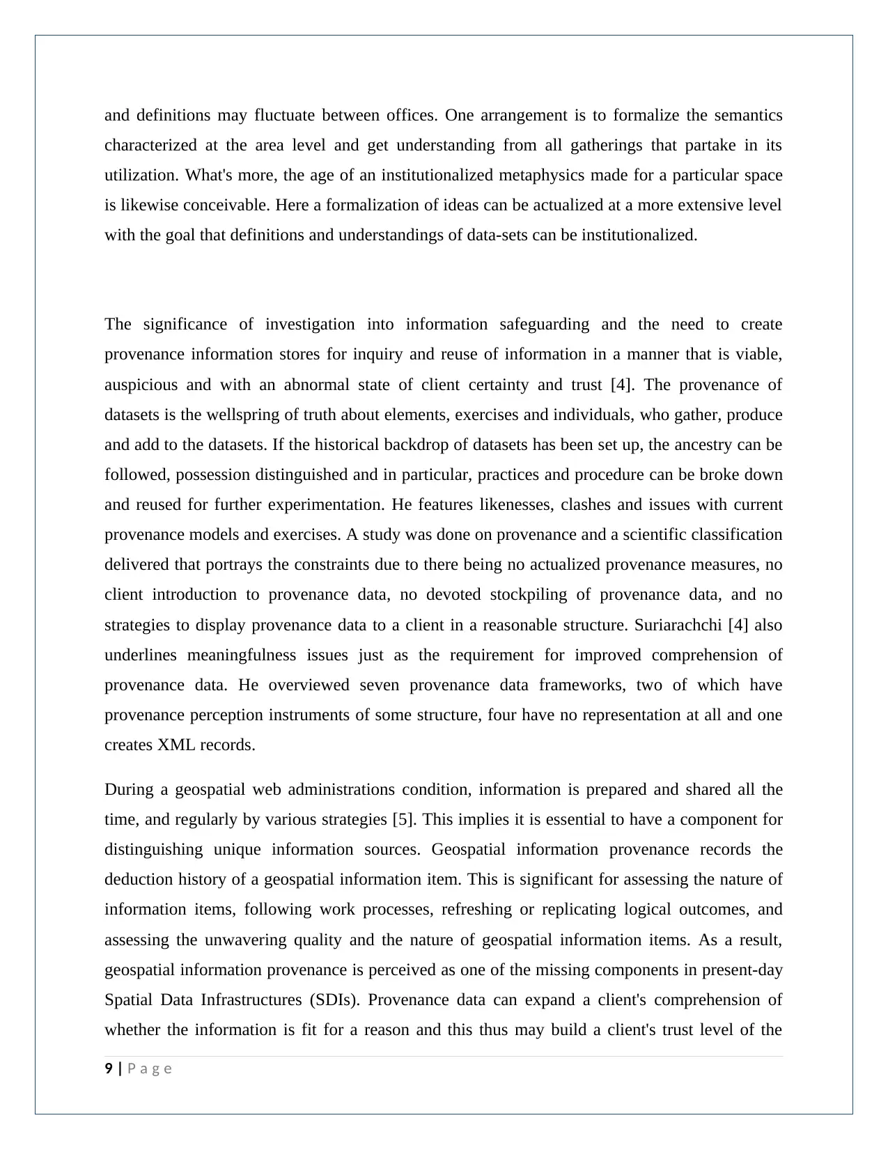
Systems of Geospatial Data Sharing with Semantic web technologies
A structure of geospatial information frameworks to Geospatial Semantic Web Technologies for
varying inheritance GIS is proposed as appeared in the following figure (Fig. 1). For moment
remote information access and trade, the cosmology based web administrations are utilized to get
to and control geospatial information through the web from heterogeneous databases. This
methodology guarantees fundamental conditions for bury operability by utilizing a standard trade
component and Geospatial Semantic Web Technologies between different spatial information
sources associated over the web.
10 | P a g e
Liuet al. [6]. They clarify how provenance data is basic in extricating quality parameters and
data. Quality measurements can be built dependent on property data and work process models.
The more trait data gathered the more datasets can be investigated from a quality point of view.
Furthermore, catching work processes distinguishes the total life cycle of an information item
and this thusly can be utilized to computerize the quality control evaluation process.
The Cooperative Research Center for Spatial Information (CRCSI) Program 3, Spatial
Infrastructures, tries to improve the association, access and utilization of spatial information in
Australia and New Zealand [7]. The examination program has grasped progressed Semantic Web
Technologies and Artificial Intelligence as methods for improving spatial information supply
chains [7].
Systems of Geospatial Data Sharing with Semantic web technologies
A structure of geospatial information frameworks to Geospatial Semantic Web Technologies for
varying inheritance GIS is proposed as appeared in the following figure (Fig. 1). For moment
remote information access and trade, the cosmology based web administrations are utilized to get
to and control geospatial information through the web from heterogeneous databases. This
methodology guarantees fundamental conditions for bury operability by utilizing a standard trade
component and Geospatial Semantic Web Technologies between different spatial information
sources associated over the web.
10 | P a g e
Paraphrase This Document
Need a fresh take? Get an instant paraphrase of this document with our AI Paraphraser
Fig. 1: Systems of Geospatial Data Sharing with Semantic web technologies
Spatial Analysis
The Spatial Analysis, the kind of topographical examination which tries to clarify examples of
human conduct and its spatial articulation as far as science and geometry, that is the examination
of location. Models incorporate closest neighbour investigation and Thiessen polygons. A
considerable lot of the models are grounded in miniaturized scale financial aspects and anticipate
the spatial examples which ought to happen, in, for instance, the development of systems and
urban frameworks, given various preconditions, for example, the isotropic plain, development
minimization, and benefit augmentation. It depends on the principle that monetary man is in
11 | P a g e
charge of the improvement of the scene, and is along these lines subject to the standard reactions
of that idea, for example, the absence of through and through freedom.
A differentiation is made in this course among GIS and spatial investigation. With regards to
standard GIS programming, the term investigation alludes to information control and information
questioning. With regards to spatial examination, the investigation centres around the factual
investigation of examples and hidden procedures or all the more, for the most part, spatial
examination tends to the inquiry "what could have been the beginning of the watched spatial
example?" It's an exploratory procedure whereby we endeavour to evaluate the watched example
at that point investigate the procedures that may have created the example.
Spatial Data Supply Chains (SDSC)
The cutting edge spatial frameworks must address numerous contemporaneous issues inside the
spatial data supply chains (SDSC). An SDSCs comprises of various worth include forms along
the chain. At each worth include point in the chain, there might be heterogeneous forms,
techniques, models and work processes consolidating to produce, adjust and expend spatial
information. The worth include procedures happening in coordinating and preparing numerous
informational collections brings up issues about information trust, quality, its qualification for a
reason, money and legitimate level. An explanation behind this is these informational collections
begun from various sources having had diverse forms executed upon them to touch base at this
last item. Knowing how information is gathered and what level of precision was utilized gives
understanding concerning what reason the information can be utilized for. The production of a
geospatial provenance model that catches these sorts of procedures will empower a capacity to
quantify how fit for reason information may be.
A huge amount of the Australian spatial information is gained at the neighbourhood government
level; it is then consolidated to frame the State or Territory level data sets and afterwards used to
make national-level data sets. Numerous procedures utilized in the spatial information age are
manual and undocumented just as certainly requiring human mediation. There is an absence of or
no connecting instruments at all between data sets. Numerous variants of informational
collections are additionally frequently being utilized which may prompt a mistaken or outdated
data set being utilized. There are conditions between the various information at various levels
12 | P a g e
⊘ This is a preview!⊘
Do you want full access?
Subscribe today to unlock all pages.
Trusted by 1+ million students worldwide
1 out of 36
Your All-in-One AI-Powered Toolkit for Academic Success.
+13062052269
info@desklib.com
Available 24*7 on WhatsApp / Email
![[object Object]](/_next/static/media/star-bottom.7253800d.svg)
Unlock your academic potential
Copyright © 2020–2026 A2Z Services. All Rights Reserved. Developed and managed by ZUCOL.